PASSPORT
First ascent to the summit of Djalgiz-Konush via the north-eastern wall of the Zub Begichi peak.
-
Class: technical.
-
Region: Alai Ridge, Kok-Su gorge.
-
Peaks: p. Zub Begichi (4100 m) via the center of the north-eastern wall, followed by a traverse to p. Djalgiz-Konush (4470 m).
-
Assumed difficulty category: 5B.
-
Route characteristics:
Total elevation gain – 1500–1700 m.
Wall:
- elevation gain: 610 m
- section length:
- 6th grade – 40 m
- 5th grade – 160 m
- 4th grade – 210 m
- 3rd grade – 200 m
- average steepness: 70°
Ridge:
- elevation gain: 400–500 m
- section length:
- 5th grade – 20 m
- 4th grade – 30 m
- average steepness: 30°
-
Number of pitons hammered for belay: rock pitons – 62 pcs.
-
Number of travel hours: 60 hours from base camp and back. 33 hours – actual travel time. Wall: processing – 2.5 hours, subsequent passage – 7.5 hours.
-
Number of nights: two.
-
Group composition: V.S. Balyberdin, 1st sports category – leader, G.G. Andreev, Master of Sports, D.M. Razumov, Candidate for Master of Sports, B.M. Silin, 1st sports category.
-
Coach: G.G. Andreev – Master of Sports of the USSR.
-
Departure and return dates: August 18–20, 1977.
TABLE OF SECTIONS
| Date | Section number | Steepness, degrees | Length, m | Terrain characteristics | Difficulty | Condition | Weather conditions | Belay | Passage | Travel hours |
|---|---|---|---|---|---|---|---|---|---|---|
| 9.08.77 | R0–R1 | 25 | 900 | rocky ascents with shelves | 1 | dry slopes | Clear | simultaneously | Departure at 5 am, 15 travel hours | |
| 9.08.77 | R1–R2 | 35 | 300 | rocks, partly destroyed | 2–3 | dry rocks | " | ledges | simultaneously | |
| " | R2–R3 | 30 | 80 | ridge | 2 | sharp, destroyed ridge | " | ledges | simultaneously | |
| " | R3–R4 | 50 | 160 | smooth slabs | 4 | dry rocks, rockfall hazard | " | 8 rock pitons | alternately | |
| " | R4–R5 | 35 | 80 | counterfort ridge | 3 | dry rocks | " | ledges, slings | simultaneously | |
| " | R5–R6 | 70 | 240 | edge on the wall | 4–5 | destroyed rocks, rockfall hazard | " | 12 rock pitons | alternately | |
| " | R6–R7 | 60 | 40 | destroyed rocks | 5 | dry rocks | " | 3 rock pitons | alternately |
Note: ice and bolt pitons were not used.
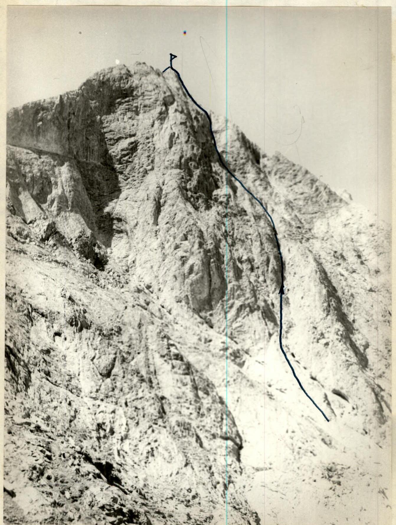
Photo I. Peak Zub Begichi (4100 m), north-eastern wall.
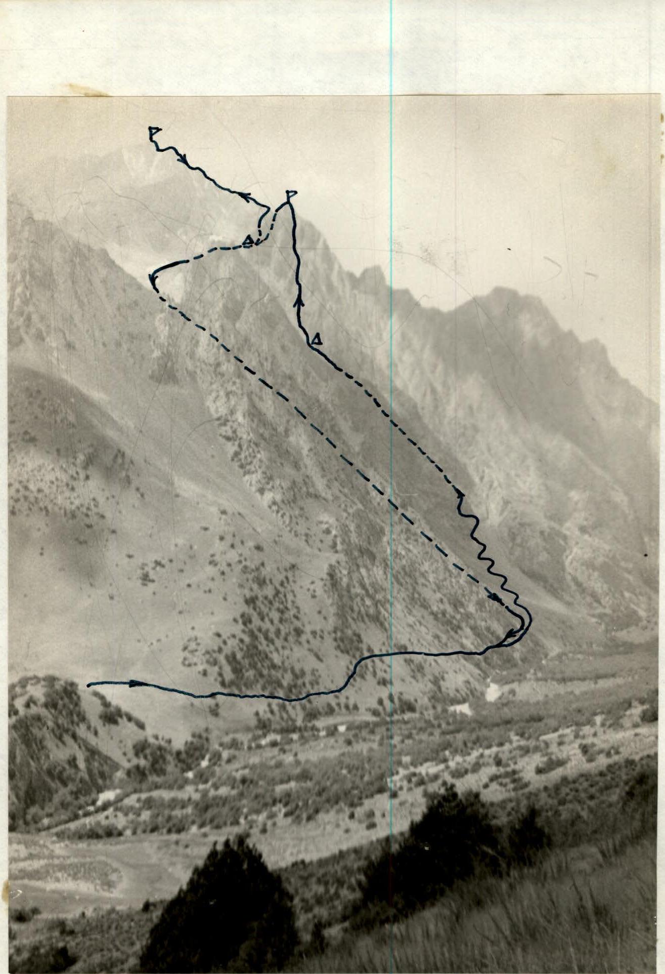
Photo 2. Route to p. Djalgiz-Konush (4470 m) via the north-eastern wall of p. Zub Begichi (4100 m). Kok-Su gorge.
DESCRIPTION
Route to p. Djalgiz-Konush via the north-eastern wall of p. Zub Begichi (first ascent, approximately 5B category).
From Kozhdeba clearing, along the right (orographic) bank of the Kok-Su river to a clearing opposite a crashed helicopter (45 minutes). Along the sloping grassy shelves of the eastern ridge of p. Zub Begichi, crossing a canyon, exit under the north-eastern wall of Zub Begichi (4 hours from camp) – photo 2. The only water source in the north-eastern cirque of p. Zub Begichi is a small snowfield under the eastern ridge. From the snowfield, approach to the wall – 30 minutes.
The general character of the north-eastern wall of Zub Begichi is a concave cylindrical surface, bounded on the right by the north-eastern counterfort (route 4B category), and on the left by a vertical convexity of the wall (photo I). The lower half of the wall is cut by two couloirs that converge into one just below the middle of the wall, forming a large talus cone at the bottom (photo II.1). From the apex of the cone – the start of the route. The left couloir is a cleft (chimney) between a sharp large ridge (on the right) and a not sharply pronounced "roller" on the wall (on the left). The cleft leads to a rounded shoulder abutting the wall. Rocks falling along the wall go into the right couloir.
The start of the route is a knob, slabs, and exit to the beginning of the cleft (chimney), where the first control cairn is set (three ropes from the top of the talus cone on the left side of the couloir, section R0–R1). Further, the route goes along:
- the cleft (section R1–R2)
- the chimney with a plug (photo II.2, section R2–R3) with an exit to the left wall of the couloir (section R3–R4)
- a rounded shoulder to the right of a cave (section R4–R5).
There are many loose rocks here, which, if careless, fall into the chimney. At the end of this section (photo II.3), a simple deviation from the route along a red fault to the left onto the ridge is visible. The route goes to the right (section R5–R6), where higher, in the center of the gray concave wall, a small vertical rib of large yellow marble blocks is visible. Here (in the lower third of the rib) under a small overhang, the second control cairn is set. From here begins the most complex section of the route: a sheer drop, partly overhanging (5–6 category).
Further, exit to a horizontal talus shelf (rockfall hazard, piton belay is difficult: rocks are tile-like, weathered – photo II.4), which to the right leads to the north-eastern counterfort (on the 4B category route). Up the counterfort, partly along shelves on the right (section R8–R9), exit to the north-western ridge under the pre-summit ascent (section R9–R10), which is traversed directly along difficult, destroyed rocks (rockfall hazard!).
Descent from the summit to the east along a steep, very narrow, and destroyed ridge (photo II.5) to a dark-brown couloir (about 80–90 m from the summit).
- Descent into the couloir for 20 m (rappel)
- Further along the couloir, exit to talus
- Down the talus (150–200 m) and to the right onto rocks, where on a "shoulder" is a bivouac.
The ascent to p. Djalgiz-Konush goes along talus and leads to the left and above the saddle to a "black gendarme". From the gendarme, to the left along shelves to the ridge, which is climbed via a 5-meter wall (section R11–R12).
The first (I) "white" gendarme is bypassed on the right along wide shelves and again exit to the ridge.
The second (II) "gray" gendarme is traversed directly (section R13–R14).
The third (III) "red" gendarme – along narrow right-hand shelves above the ice.
The fourth (IV) gendarme starts from the ridge with large gray blocks. Movement to the right along small steps, and then along a strongly destroyed wall (5–6 m) – exit to the ridge.
The fifth (V) pre-summit gendarme is bypassed on the right along talus shelves with a slight descent down (20–30 m).
The northern (lower) summit is also bypassed on the right along talus shelves.
Exit to a wide and even saddle under a 40-meter wall – the summit tower (piton belay):
- the first 20 m – sheer,
- further, a gradual flattening, turning into the summit destroyed ridge.
Descent along the ascent route. From the summit tower, rappel 20 m (an ice piton is hammered).
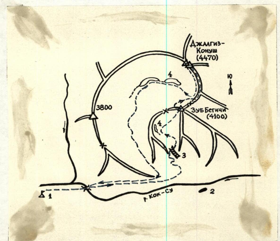
Map of the area of ascent to p. Djalgiz-Konush via the north-eastern wall of p. Zub Begichi.
- Base camp.
- Crashed helicopter.
- Canyon.
- Snowfield.
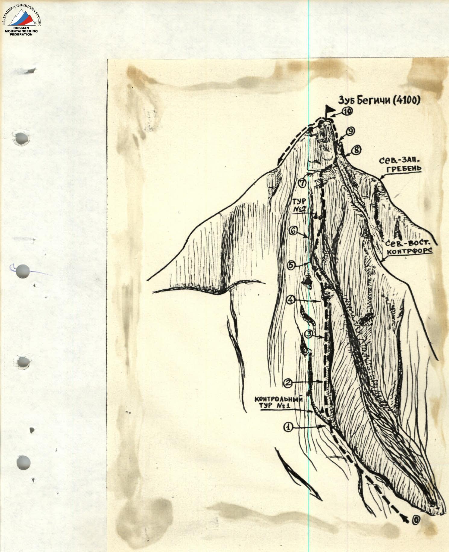
Scheme of the route to p. Djalgiz-Konush via the north-eastern wall of p. Zub Begichi. R0, R1, R2, … R10 – conditional section numbers according to Appendix 2.
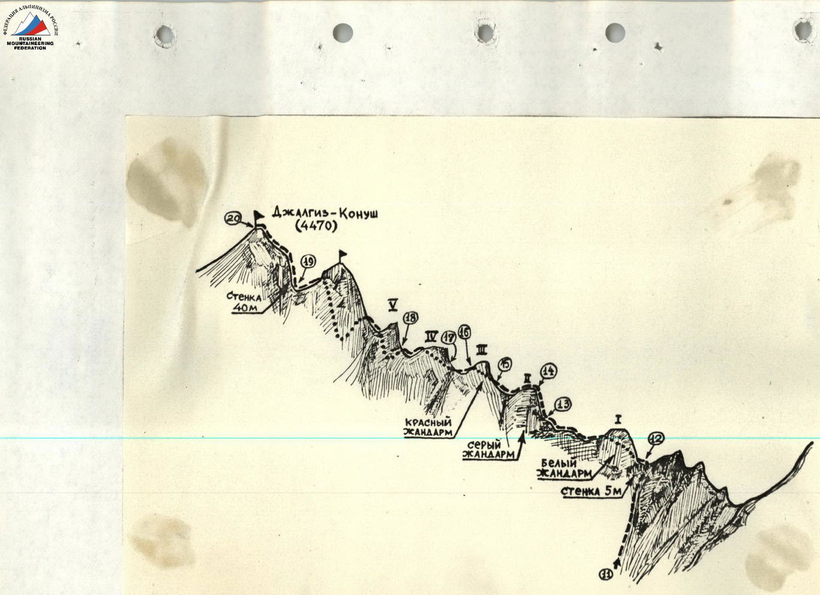
Scheme of the route to p. Djalgiz-Konush. R11, R12, … R20 – conditional section numbers according to Appendix 2.
APPENDIX № 2 (continued)
TABLE OF SECTIONS (continued)
| Date | Section number | Steepness, degrees | Length, m | Terrain characteristics | Difficulty | Condition | Weather conditions | Belay | Passage | Travel hours |
|---|---|---|---|---|---|---|---|---|---|---|
| 19.08.77 | R0–R1 | 30 | 160 | knob, slabs | 3 | solid | Clear | 4 rock pitons | alternately | Departure at 6:30 am |
| " | R1–R2 | 60 | 40 | chimney | 4 | loose | " | 5 rock pitons | alternately | |
| " | R2–R3 | 80 | 40 | narrow chimney with a plug | 5 | normal | " | 6 rock pitons | " | |
| " | R3–R4 | 80 | 40 | left wall of the chimney | 5 | " | " | 6 rock pitons | " | |
| " | R4–R5 | 50 | 100 | edge | 4 | " | " | 8 rock pitons | " | |
| " | R5–R6 | 80 | 40 | wall | 5 | " | " | 4 rock pitons | " | |
| " | R6–R7 | 85 | 80 | " | 5–6 | " | " | 16 rock pitons | " | |
| " | R7–R8 | 10 | 40 | shelf, loose rocks | 3–4 | " | " | 1 rock piton | " | |
| " | R8–R9 | 60 | 30 | counterfort | 4 | " | " | 2 rock pitons | " | |
| 19.08.77 | R9–R10 | 70 | 40 | slabs | 5 | normal | clear | 3 rock pitons | alternately | |
| " | R10–R11 | 45 | 300 | ridge, couloir, talus | 3 | " | " | " | ||
| " | R11–R12 | 20 | 200 | talus | 1 | " | " | simultaneously | ||
| " | R12–R13 | 30 | 160 | ridge | 2–3 | " | " | " | ||
| " | R13–R14 | 60 | 20 | wall | 3 | " | " | " | ||
| " | R14–R15 | 20 | 80 | ridge | 2 | " | " | " | ||
| " | R15–R16 | 50 | 20 | shelf | 3 | " | " | 1 rock piton | alternately | |
| " | R16–R17 | 30 | 100 | ridge | 2 | " | " | 1 rock piton | simultaneously | |
| " | R17–R18 | 50 | 20 | wall | 3 | destroyed | rocks | 1 rock piton | alternately | |
| " | R18–R19 | 30 | 160 | ridge | 2 | " | " | simultaneously | ||
| " | R19–R20 | 70 | 80 | wall, ridge | 4 | " | " | 3 rock pitons | alternately |
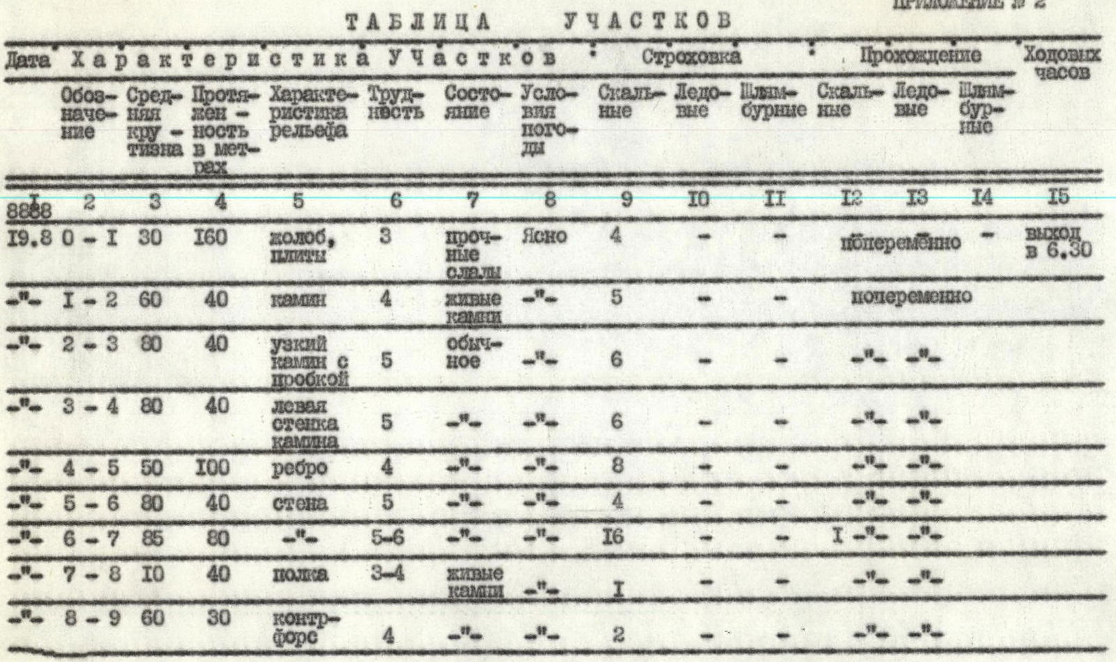
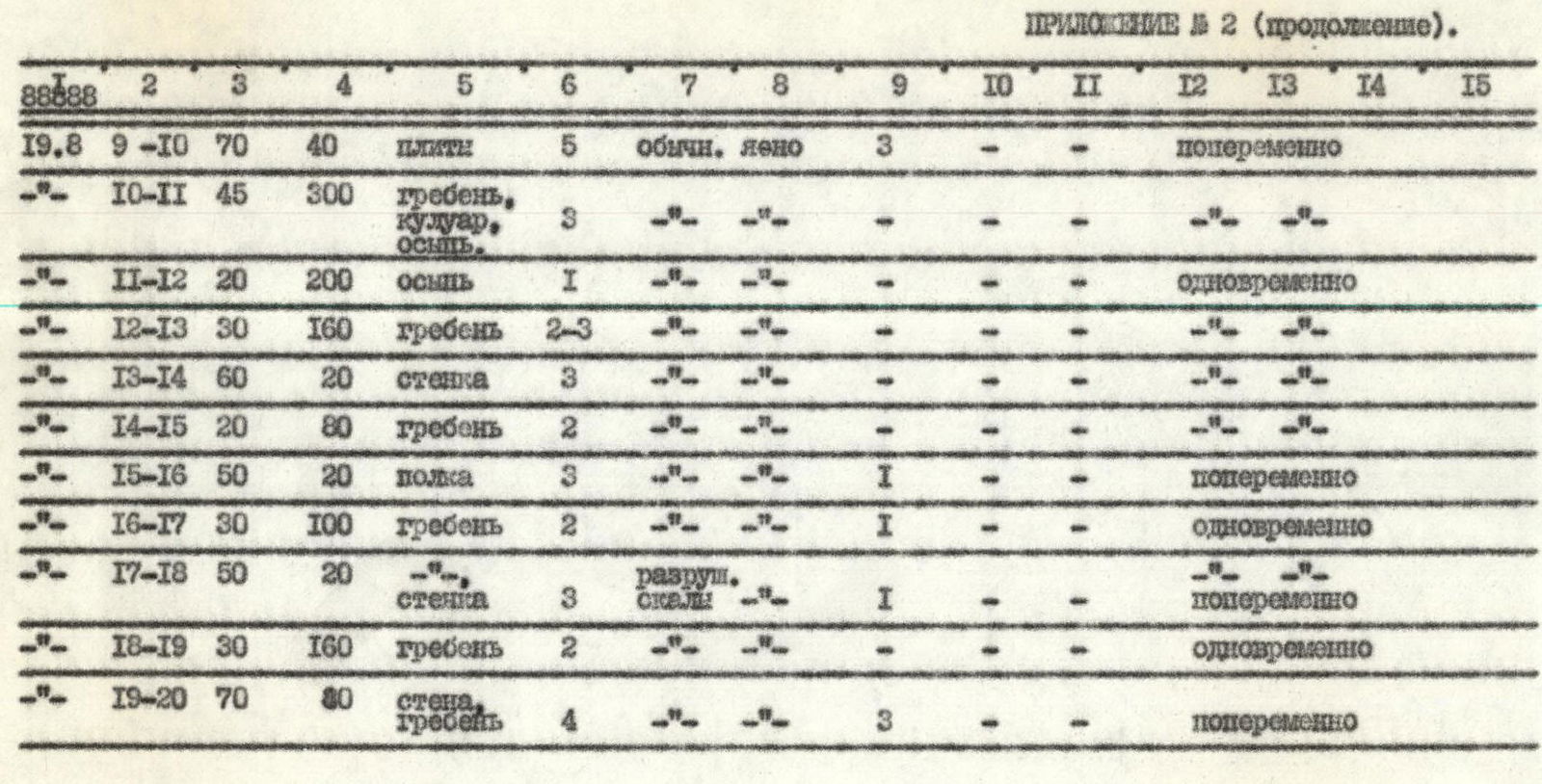
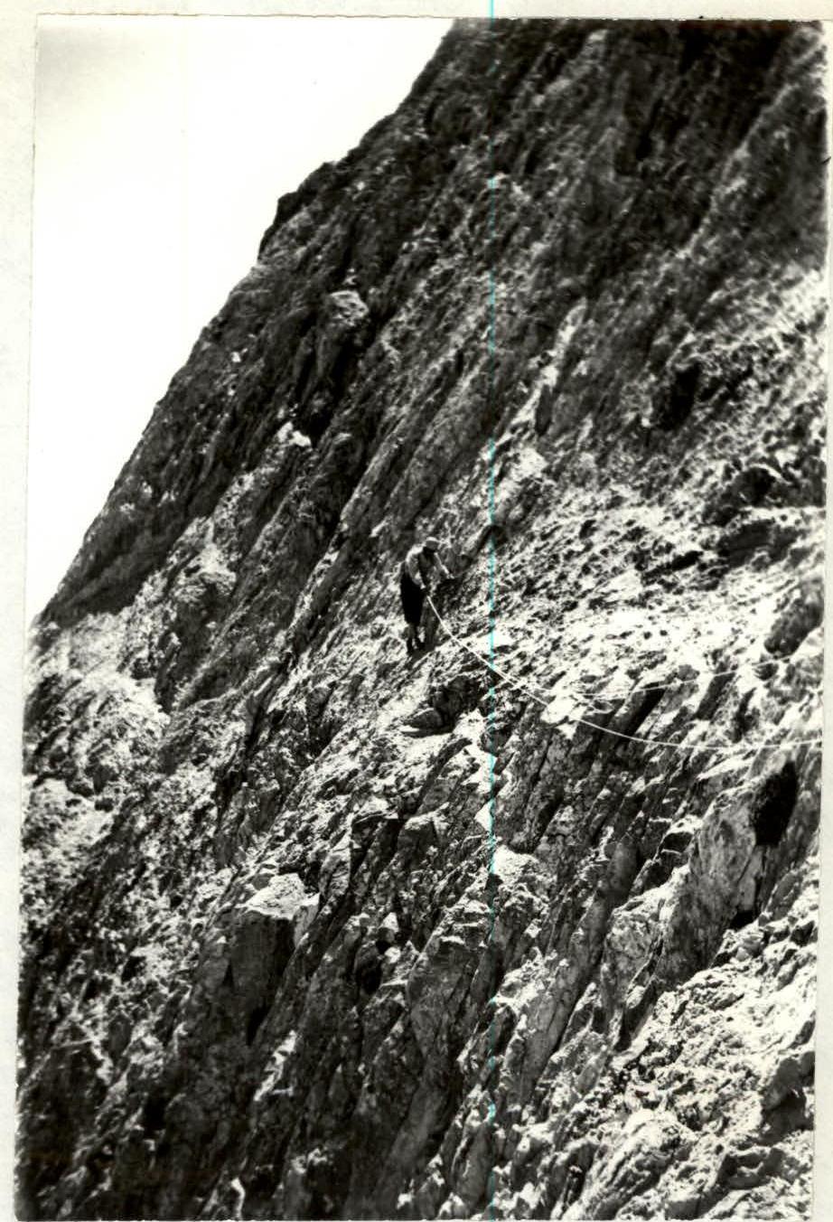
Photo II.4. North-eastern wall of p. Zub Begichi. Horizontal shelf under the summit part of the wall (section R7–R8).
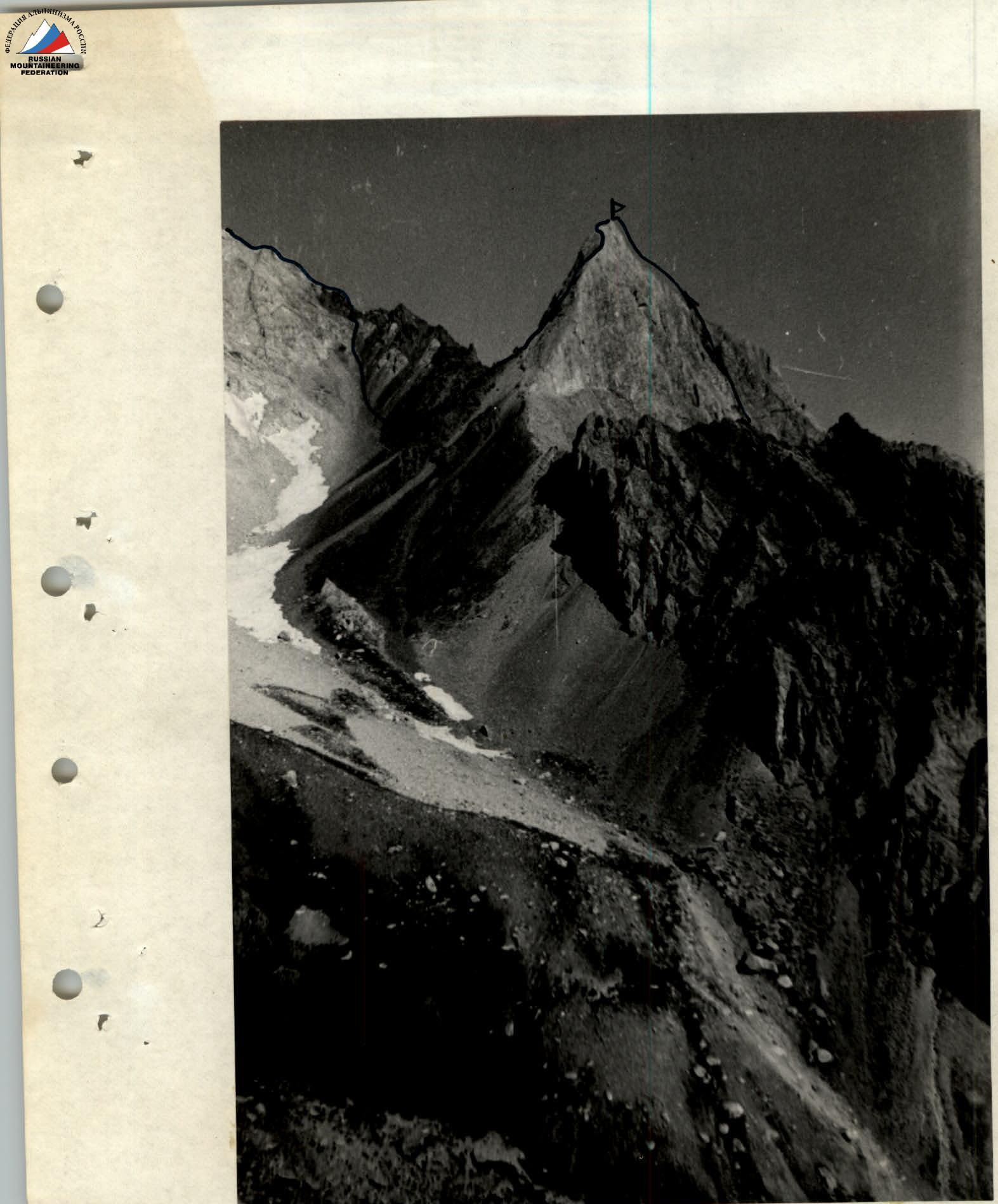
Photo II.5. Peak Zub Begichi (view from the east). On the left is a saddle and the northern ridge of p. Djalgiz-Konush.