Passport
- Section number according to KMGV - 2010 - 8.3.47
Polar Ural, Raiiz mountain massif, Sob River valley.
- Name of the peak: 1309.0 (Pik Polarny) - 1287 (Pik Topografov)
height: 1309.0–1287
route: traverse from west to southeast
- Category of difficulty: proposed 2Bz, pp.
- Character of the route - combined.
- Height difference of the route: 540 m
- Length of the route: 6600 m
- Length of sections with the highest category of difficulty:
1st category of difficulty - 2 sections - 2500 m, 2nd category of difficulty - 3 sections - 3100 m, 3 - 30 m, 4 - 0 m, 5 - 0 m, 6 - 0 m.
- Average steepness: main part of the route - 50 degrees.
entire route - 45 degrees.
9. Pitons used:
Total pitons used on the route:
- rock pitons - 0
- chocks - 0
- stationary pitons - 0
- ITO - 0
- removable pitons - 0. "Pitons" left on the route: total - 0; including stationary pitons - 0.
- Departure on the route - 6:00 March 9, 2006
Ascent to the summit - 12:00; 15:00 March 9, 2006 Return to the base camp - 20:00 March 9, 2006
- Team's working hours: - 14 hours.
- Team leader: Goletarov Andrey Mikhailovich (2nd sports category, Inta).
Participants:
- L. Kaneva (3rd sports category, Syktyvkar)
- E. Burtsev (3rd sports category, Syktyvkar)
- K. Tolstikov (3rd sports category, Syktyvkar)
- Coach: Zhuravlev Sergey Vasilyevich, title - CMS, instructor-methodologist 1st category.
Description of the peaks
Peak 1309 m (Pik Polarny) - one of the peaks of the Raiiz mountain massif, located in the Yamalo-Nenets Autonomous Okrug (YaNAO) of the Tyumen Oblast, Ural Federal District of the Russian Federation, on the eastern slopes of the Polar Ural, on the northwest of the Raiiz mountain massif, on the watershed of the mountain valleys of the rivers:
- Nyrvomen-Shor (north),
- Sob (west),
- Enga-Yu (southeast).
The peak is a pronounced three-faced pyramid. Height - 1309.0 m. The name is unofficial but has taken root in the tourist and mountaineering community.
Peak 1309 (Pik Polarny) can be an object for training and sports ascents, as it has several pronounced rocky ridges.
Peak 1287 (Pik Topografov) - one of the peaks of the Raiiz mountain massif. Located in the Yamalo-Nenets Autonomous Okrug (YaNAO) of the Tyumen Oblast, Ural Federal District of the Russian Federation, on the eastern slopes of the Polar Ural, on the northwest of the Raiiz mountain massif, on the watershed of the mountain valleys of the rivers:
- Nyrvomen-Shor (north),
- Sob (west),
- Enga-Yu (southeast).
The peak has a pronounced rocky tower, similar to a trapezoid. Height - 1287 m. The name is unofficial, not found on the General Staff maps, but has firmly taken root in the tourist and mountaineering community.
Peak 1287 (Pik Topografov) can be an object for training and sports ascents, as it has several pronounced ridges, walls, and counterforts.
Description of the route:
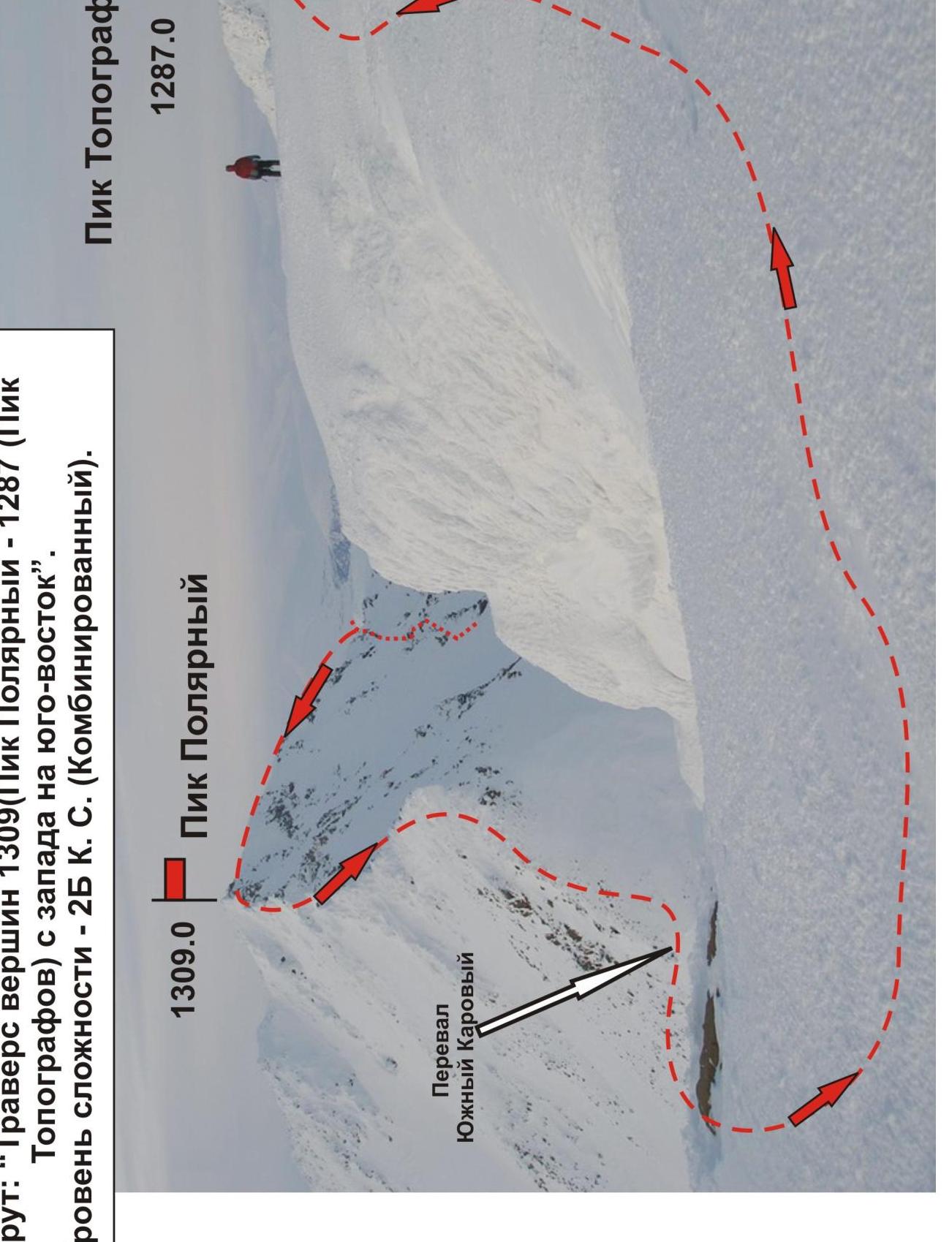
"Traverse of peaks 1309 (Pik Polarny) and 1287 (Pik Topografov) from west to southeast" 2B category of difficulty (combined).
The route: "Traverse of peaks 1309 (Pik Polarny) and 1287 (Pik Topografov) from west to southeast" 2B category of difficulty (combined). A typical training route of the second category of difficulty, with a full range of natural obstacles.
Passing this route has not only aesthetic but also practical training significance, as it allows for working out belaying and self-belaying techniques on rocky and snowy-icy terrain. The route is ridge-like, allowing for training ascents both in winter and summer.
Equipment
For a training and sports ascent with a group of 6 people (5 participants + instructor), the following special equipment is necessary:
Personal:
- Crampons
- Ice axe - mandatory
Group:
- Main rope 10 mm - 3×50 m
- Rock hammer - 1 piece
- Rock pitons - 6 pieces
- Ice axe - 1 piece
- Chocks - 6 pieces
- Ice screws - 6 pieces
- Quickdraws - 6 pieces
- Slings - 8 pieces
Approach
From the Polar Ural railway station, along the Sob River valley - in winter on skis, in summer on a dirt road - approach to the cirque formed by the western ridge of peak 1309 (Pik Polarny), the general rocky ridge to the east, and the western ridge of peak 1287 (Pik Topografov) - takes 4-6 hours.
The base camp can be conveniently set up near a lake (water level elevation 667.0) on the talus fields of the mountain tundra. (Cooking on stoves, gas burners).
From the lake, located at the foot of the mountain, the route begins.
Technical part
The route represents a cumulative set of obstacles from two routes:
- 2A category of difficulty to peak 1309 (Pik Polarny) along the western ridge
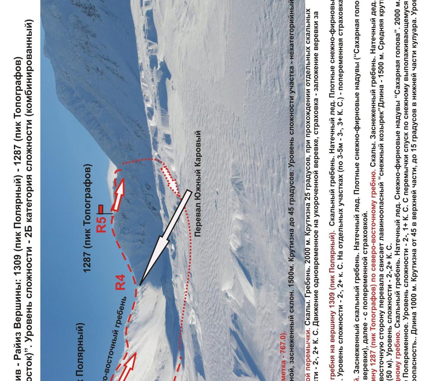
- the upper, most complex part from the Yuzhny Karovyy pass, route 1B category of difficulty to peak 1287 (Pik Topografov) along the northeastern ridge
From the base camp "U ozera" (By the lake), ascend along the couloir to the Yuzhny Karovyy pass.
Then:
- Ascend along the pronounced rocky ridge.
- A long rocky ridge, in winter covered with 3-4 cm of ice (winter and very hard).
- Rocks of 2nd category of difficulty with short sections of slabs and walls - 3rd category of difficulty, height up to 5-10 m.
- The ridge is built pyramidally, with rocky steps of 3-7 m, without sharp drops in height in the lower sections.
Movement is carried out with alternating belays, intermediate points - outcrops of the ridge, large stone blocks. The use of ice screws is not feasible due to insufficient ice depth; the use of chocks is also difficult due to ice-filled cracks.
Then - descent to the Yuzhny Karovyy pass. Initially, 2-3 sports descents from the rocky tower along a fixed rope, followed by climbing with alternating belays.
From the Yuzhny Karovyy pass, ascend along the pronounced rocky ridge of medium steepness.
- In the lower part - simultaneous movement with rope placement behind outcrops
- In the upper part - 100 m of movement with alternating belays
In winter, it is convenient to organize a via ferrata in the upper part, as climbing is complicated by hard winter ice; ice also fills cracks, complicating the organization of intermediate belay points.
Peak 1287 (Pik Topografov) - a small talus plateau. No cairn found.
Descent from the summit
Along the northwestern ridge to the pass saddle in the ridge. Then, along a gentle couloir, descend into the western cirque. In case of bad weather, it is more convenient to descend from both peak 1309 and peak 1287 (Pik Topografov):
- first to the Yuzhny Karovyy pass,
- then along the western couloir into the western cirque via route 1B category of difficulty.
1–2 — Passage along the western ridge to the pass saddle. Rocks. Ridge. 2000 m. Steepness 25°, when passing individual rocky sections of 2–10 m - steepness up to 70°. Level of difficulty - 2-, 2+ category of difficulty. Movement is simultaneous on a shortened rope, belaying - by placing the rope; in some cases - alternating belays.
2-3 — ascent from the pass saddle of the western ridge to peak 1309 (Pik Polarny). Rocky ridge. Ice. Dense snow-firn drifts ("Sugar Head"). 600 m. Steepness - 45–55 degrees. Level of difficulty - 2-, 2+ category of difficulty. On individual sections (3–5 m - 3-, 3+ category of difficulty) - alternating belays. When approaching the summit tower - 100 meters - via ferrata.
3–4 — descent from the summit to the Yuzhny Karovyy pass. Snowy rocky ridge. Ice. Dense snow-firn drifts ("Sugar Head"). Descent from the summit tower - by sports method (4 ropes), then - with alternating belays.
4-5 — ascent from the Yuzhny Karovyy pass to peak 1287 (Pik Topografov) along the northeastern ridge. Rocks. Snowy ridge. Ice. Snow-firn drifts ("Snow Head"). Attention - on the eastern side of the pass hangs a potentially avalanche-prone "snow cornice". Length - 1500 m. Average steepness - 45°, when exiting to the summit tower - 60° (50 m). Level of difficulty - 2-, 2+ category of difficulty.
Descent from peak 1287 (Pik Topografov) along the southwestern ridge. Rocky ridge. Ice. Snow-firn drifts ("Sugar Head"). 2000 m (to the pass saddle), steepness - 45°. Movement - alternating. Level of difficulty - 2-, 1+ category of difficulty. From the saddle - descent along a snowy, gradually flattening slope, leading to the western cirque. Subjective avalanche danger. Length - 1000 m. Steepness - from 45° in the upper part to 15° in the lower part of the couloir. Level of difficulty - 1 category of difficulty.
Polar Ural. Raiiz mountain massif. Route: "Traverse of peaks 1309 (Pik Polarny) - 1287 (Pik Topografov) from west to southeast". Level of difficulty - 2B category of difficulty (Combined).