24 21а
V. Blagoeva S.saddle V.M. Mokhova Altai
Passport
- Rock class.
- Altai, Katunsky ridge.
- Assumed 1B category of difficulty, first ascent.
- Height difference 150 m, length 1200 m.
- 6.5 hours from the camp under Boris peak.
- V.M. Mokhova 1st sports category P.A. Belyaev 3rd sports category, K.E. Vinnikov 1st sports category, L.M. Egorov 3rd sports category, V.V. Katonin 2nd sports category.
- Coach A.V. Drakin, CMS, 1st sports category #3450.
- Departure and return on July 15, 1994.
- Event organized by Altai Regional Sports Committee.
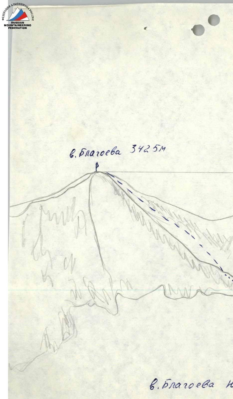
- Height 3425 m.
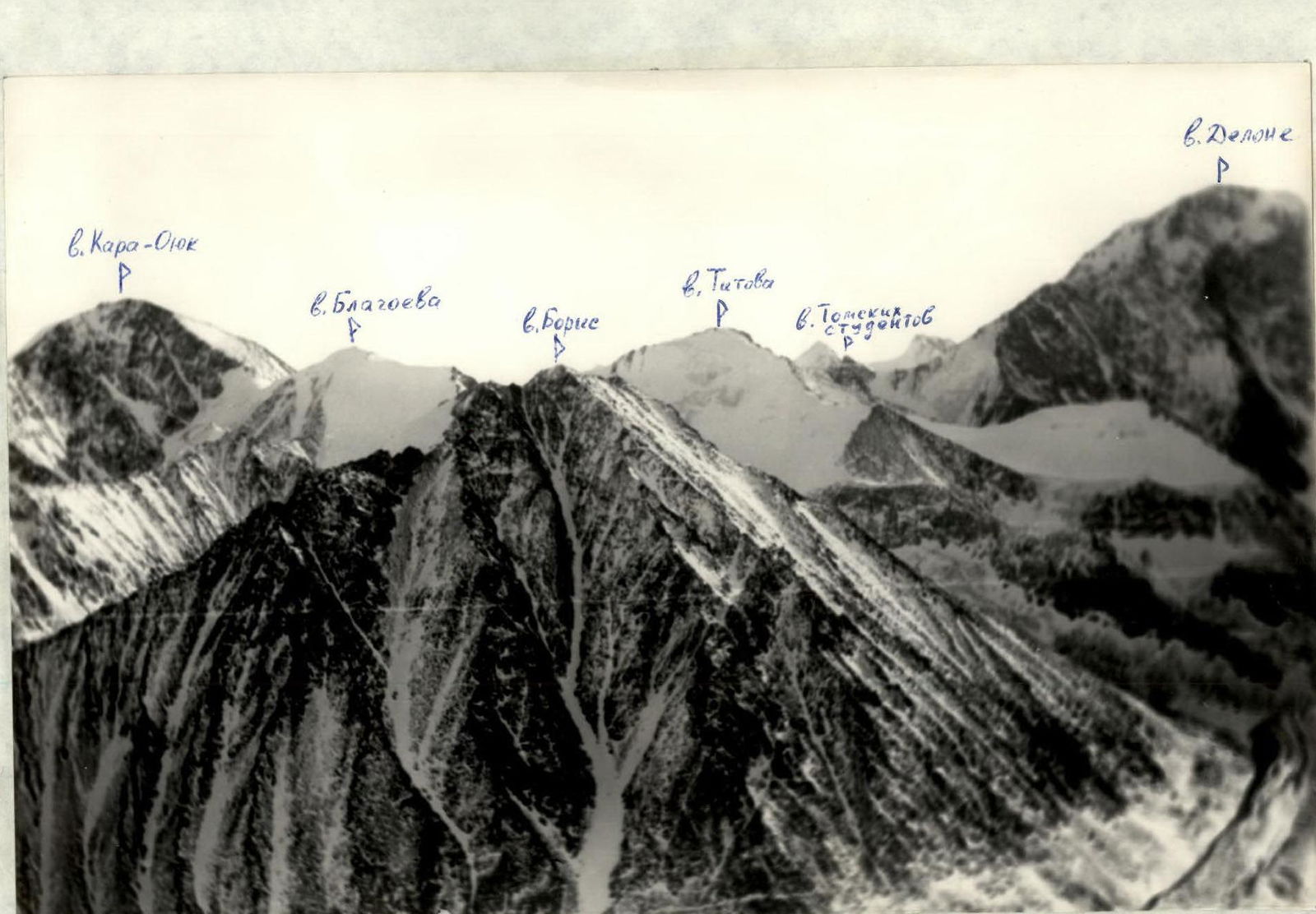
View of the peaks: Kara-Oyuk, Blagoeva, Boris, Titov, Studentov, Delone. Taken from V. Bronya, Point 1.

V. Blagoeva S.saddle, Kara-Oyuk pass, V. Titov, Druzhba pass, Kara-Oyuk. Taken from V. Titov, point #2.

V. Blagoeva, Kara-Oyuk, Druzhba pass. Taken from 3rd group V. Titov, Point #3.
Approach Description
From the base camp located on Akkem lake, move along the lake to the point where the Akkem river flows into the lake (40–50 minutes). The river is crossed with fording, using safety precautions. After crossing, move along the trail to the Akkem glacier (the trail often disappears on the large talus). Ascend to the glacier tongue from the left, following the lateral moraine. Then proceed along the glacier tongue, alongside the slopes of Boris peak, towards the start of the 0–3 ridge.
The moraine rampart on the left separates a convenient campsite with a small lake from the glacier. The descent to the campsite is via large talus covered with lichen, which becomes very slippery in the rain.
Travel time from the camp to the campsite: 3–3.5 hours.
V. Blagoeva S.saddle
Bivouac
From the base camp located under Boris peak, move towards Druzhba pass between V. Blagoeva and V. Titov. Initially, traverse the moraine, which consists of medium and large talus, then proceed across the glacier under the pass. Reach the pass through rocky outcrops, crossing the bergschrund under the pass via snow bridges (2 hours 30 minutes).
From the pass, move:
- initially along a gentle, broken ridge, proceeding in rope teams,
- then, bypassing two gendarmes on the right, without reaching the ridge, ascend to the summit via medium and large talus (1 hour 30 minutes).
Descent follows the ascent route (2 hours 30 minutes).
V. Blagoeva 3425 m.
R1–R2, 20°, 1000 m. R0–R1, 20–25°, I+, 200 m. R0. Druzhba pass. V. Blagoeva S.saddle.
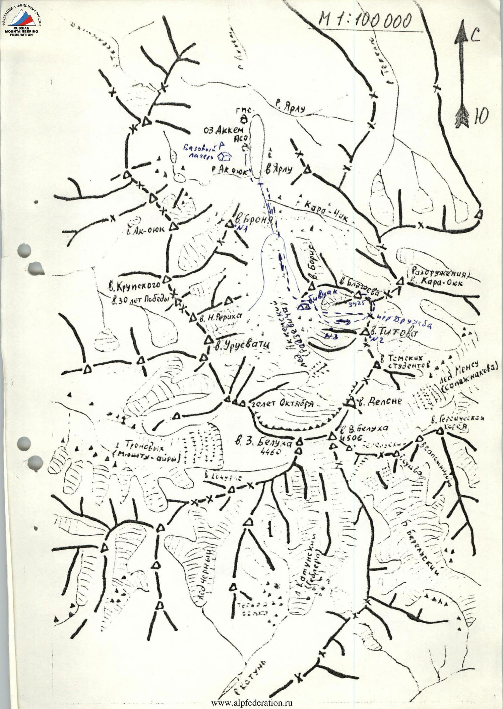
Map of the area, scale 1:100000. Indicated: R. Yarlu, Akkem lake, base camp, Ak-Oyuk, Kara-Oyuk, V. Bronya, V. Krupskogo, 8.30 let Pobedy, V. N. Roerich, V. Urusvati, Tronovykh (Myshtu-Airyu), Aid Cherny, Golet Oktyabrya, V.3. Belukha, Ekatun, V. Boris, Bivouac, V. Blagoeva, Razoruzheniya, D. Kara-Oyuk, Druzhba pass, D. Titov, 18 Tomskikh studentov, V. Delone, V. Belukha, Mensu glacier (Sopazhnikov), V. Geroicheskaya Koreya, V. Sapozhnikov.