Report on the Ascent of Shaitankhana (Kotina Peak) via the "Operatsiya KIK" Route on the Inner Corner of the Western Wall and the Center of the Upper Bastion, Category 6A Complexity, by the Team from Krasnoyarsk Krai from July 19, 2023 to July 21, 2023
I. Climbing Report
| 1. General Information | ||
|---|---|---|
| 1.1 | Full Name, Sports Rank of the Leader | Korulin Evgeny Sergeevich (Master of Sports) |
| 1.2 | Full Name, Sports Rank of the Participants | Volkov Igor Vladimirovich (Candidate Master of Sports) |
| 1.3 | Full Name of the Coach | Balezine Valery Viktorovich |
| 1.4 | Organization | Krasnoyarsk Krai Alpine Federation |
| 2. Characteristics of the Climbing Object | ||
| 2.1 | Region | Gissar-Alay |
| 2.2 | Valley | Karavshin |
| 2.3 | Section Number according to the 2013 Classification Table | 5.4.3. |
| 2.4 | Name and Height of the Peak | Shaitankhana (Kotina), 4521 m |
| 2.5 | Geographical Coordinates of the Peak (Latitude/Longitude), GPS Coordinates | 39°36′15″N 70°16′11″E |
| 3. Characteristics of the Route | ||
| 3.1 | Name of the Route | "Operatsiya KIK" — via the inner corner of the western wall and the center of the upper bastion. Variant passage. |
| 3.2 | Proposed Category of Complexity | 6A |
| 3.3 | Degree of Route Development | Second ascent, variant |
| 3.4 | Relief Characteristics of the Route | Rock climbing |
| 3.5 | Height Difference of the Route | 1174 |
| 3.6 | Route Length (in meters) | 1450 |
| 3.7 | Technical Elements of the Route (total length of sections of varying complexity with indication of relief character (ice-snow, rock)) | Rock Climbing cat. 1 — 100 m. Rock Climbing cat. II–III — 450 m. Rock Climbing cat. IV — 185 m. Rock Climbing cat. V — 320 m. Rock Climbing cat. VI — 620 m. Rock A1 — 21 m. Rock A2 — 35 m. |
| 3.8 | Average Steepness of the Route, (°) | 75 |
| 3.9 | Average Steepness of the Main Part of the Route, (°) | 83 |
| 3.10 | Descent from the Summit | Via the southern ridge and western wall |
| 3.11 | Additional Characteristics of the Route | Overnight stay on a ledge, separating "Ukhodyashchiy" from the edge |
| 4. Characteristics of Team Actions | ||
| 4.1 | Time of Movement (team's walking hours, in hours and days) | 20 hours |
| 4.2 | Overnight Stays | On a ledge |
| 4.3 | Time of Route Processing | No processing |
| 4.4 | Start of the Route | 8:00, July 19, 2023 |
| 4.5 | Reach the Summit | 17:00, July 20, 2023 |
| 4.6 | Return to Base Camp | 10:30, July 21, 2023 |
| 5. Characteristics of Weather Conditions | ||
| 5.1 | Temperature, °C | July 19 (+14 °C day / +4 °C night); July 20 (+9 °C day / +2 °C night) |
| 5.2 | Wind Speed, km/h | July 19 — 0–10 km/h; July 20 — 0–20 km/h |
| 5.3 | Precipitation | July 19 — no precipitation; July 20 — rain during descent |
| 5.4 | Visibility, m | July 19 — good; July 20 — good |
| 6. Person Responsible for the Report | ||
| 6.1 | Full Name, e-mail | Korulin E.S., turistas34@mail.ru |
II. Climbing Description
1.1. Characteristics of the Climbing Object
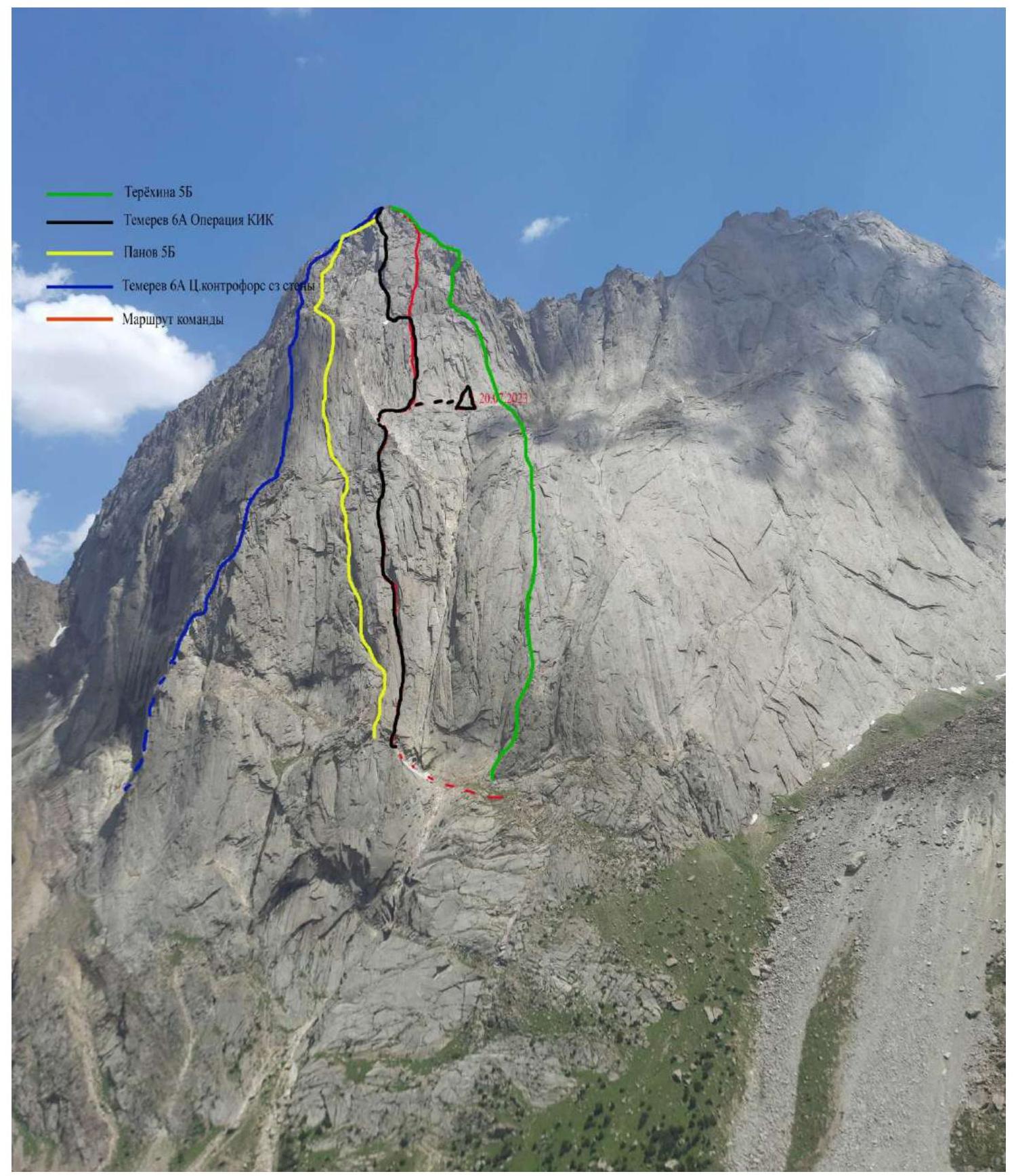
The Karavshin region is located in the Batken region of Kyrgyzstan and is considered a mecca for technical mountaineering, attracting climbers from across the post-Soviet space and beyond. Most routes in Karavshin are categorized as 5B and 6B difficulty, and the area is relatively compact and cohesive.
Shaitankhana Peak, also known as Kotina Peak (4521 m), is situated near the standard base camp location in the Karasu valley. The first ascents to the summit date back to 1988, marking the beginning of the region's exploration. The ridge formed by Shaitankhana, Kyrkchilta, and Odessa is a classic composition for photographs taken by most tourists and climbers visiting the area.
The relief of the western exposure of the mountain is diverse and relatively safe for climbing and belaying. The route taken by the team was logical, relatively safe, and interesting.
1.2. General Photo of the Summit
View from the summit of Yellow Wall 3800 m.
2. Characteristics of the Route
2.1. Technical Photograph of the Route
2.2. Route Description by Sections
The approach to the start of the route — from the base camp in the Karasu valley, follow the trail towards Peak Odessa for about 30 minutes. Proceed to the second large blocky scree. From there, head left upwards along the scree, orienting towards a couloir that leads to the upper tier. Ascend via simple rocks and the couloir (keeping to the left side) to the start of the route. Approximately 30–40 minutes.
2.3. Route Diagram in UIAA Symbols
| Section | Pitons / Hooks | UIAA Category | Length, m | Steepness, ° |
|---|---|---|---|---|
| R0–R1 | 2 / 7 | VI | 50 | 70–75 |
| A1 | 1 | |||
| R1–R2 | 8 / 2 | VI | 60 | 65–70 |
| ... | ... | ... | ... | ... |
3. Characteristics of Team Actions
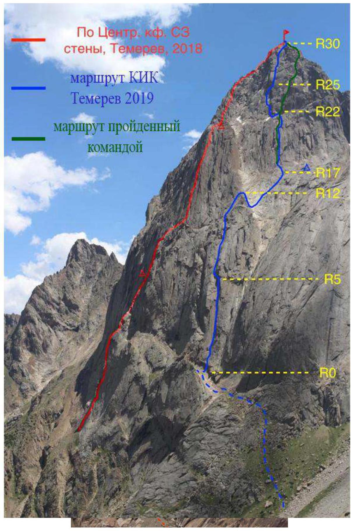
When choosing the route, we considered the following: we wanted to climb Shaitankhana and complete the route using free climbing for both participants. We selected Temerev's "Operatsiya KIK" route. The giant inner corner at the beginning of the route was particularly appealing. However, Temerev's description included sections that required artificial aids (on the upper bastion). Therefore, we initially planned to deviate from the original line on the upper bastion to create a variant that could be completed without artificial aids.
To facilitate free climbing for the second participant, we minimized the weight of the rucksack as much as possible. We took the minimum necessary food, water, clothing, and bivouac gear. Despite our efforts to lighten the load, the rucksack still weighed 12 kg. With this weight, the second climber could ascend using top-rope climbing.
Outcome
We successfully completed the route using free climbing for both participants, as planned. Our variant differs from Temerev's route on 8 sections. It is simpler than "Operatsiya KIK" because it lacks complex artificial aids, but it is still not considered easy and is more challenging and labor-intensive than other 5B routes in the area. Therefore, we believe our variant deserves a category 6A rating.
3.3. Safety Assessment of the Route and Recommendations for Future Climbers
We consider the route to be relatively safe, logical, and interesting, worthy of a 6A category.
Recommendations for the ascent: a double set of protection gear up to #3 cam, one #4 cam, 11 anchor pitons, rock shoes, trad protection for hands (or) medical tape, and a double 60 m rope, as rappelling is done with 60 m ropes. There are sufficient ledges for a tent on the route.