
The Matcha mountain node is the junction of three huge ridges: Altai, Turkestan, and Zeravshan. All of them are part of the Pamir-Alay system.
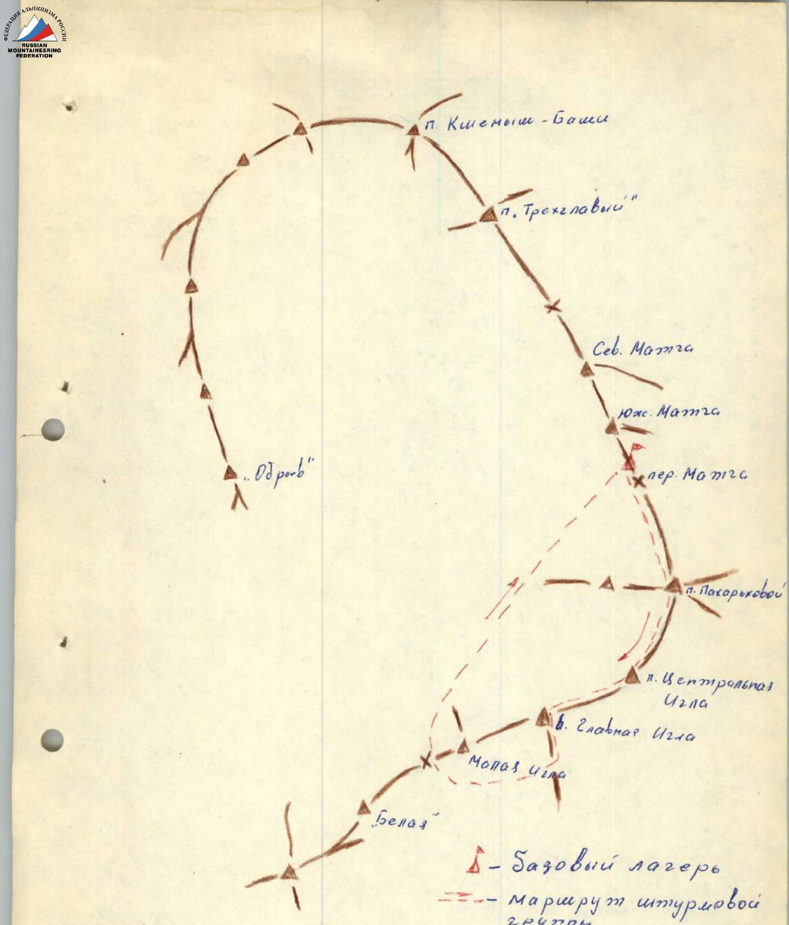
In the southwest direction from Matcha Pass is located Peak Igla. This summit closes the main flow of the Zeravshan Glacier and is like the center of the entire node. Peak Igla is a rocky ridge. It is not a separate pointed peak, as one might assume judging by the name, but several pointed peaks united in a single massif.
- North Peak (4430 m) — named after Peak Lyubov Yakovlevna Pakharkova — Honored Master of Sports of the USSR in mountaineering.
- Middle Peak (4510 m) — Central Igla.
- Southwest Peak (4530 m) — Main Igla.
Traversing the Igla massif from Matcha Pass is rated 5A category of difficulty (approximately by Yu. MALYKHIN — team leader, A. DAVYDOV, L. EGOROV, N. ORLOV).
August 5, 1969. From the assault camp located on Matcha Pass (3870 m):
- Ascend via the glacier, bypassing the spur from the left side (when looking up) to the bergschrund.
- From the bergschrund — up the snowy slope to the snowy ridge and along it to the rocky wall.
- The ascent up the wall begins via a 12-meter crevice to a ledge (rocks are snow-covered).
- Then — up an internal corner with a crevice («live» rocks) 18 m (pitons).
Further, 200 m along the rocky slope with small walls and snowy islands, staying on the left side.
Traverse right-up 80–100 m, exit to a ledge. Along the ledge 10–15 m, then cross a couloir with flowstone ice 10 m under the gendarme «Paryus» (Sail). Bypass the gendarme on the right via a sloping narrow 20-meter ledge and exit to the ridge under the wall of the summit tower (pitons). Up the wall of the tower 80 m straight up to the North Peak (Pakharkova Peak).
The rocks of the summit tower are large-block, with spalls, many «live» rocks, requiring great caution and attention, piton belay.
Descend along the rocky ridge to the lower saddle before the «gendarme». Then descend along the left slope (in the direction of travel) 50 m, bypassing the «gendarme» via ledges, exiting to the right side of the couloir.
Ascend up the right side of the couloir along the boundary between rocks and ice 80 m. Then 10 m up the wall and 10 m up the icy couloir — exit to the snowy ridge behind the gendarme (pitons).
Ascend up the snowy ridge, transitioning into a snowy slope 30 m to rocks (ice axe, pitons). Right-up 20 m along rocks with snowy islands, exit to the ridge.
Traverse left 10 m along the wall at the boundary between ice and rocks of the wall, 10 m straight up the wall and further 10 m along the ridge with snow-covered rocks.
Steep snowy slope 20 m. Move in three stages, belay via ice axe.
Further, gentle snowy rises of the ridge, with large cornices on the left.
Up a rocky wall 10 m to the summit of Central Igla.
Descend along the ridge, rocks of medium difficulty, gendarmes are passed directly «head-on».
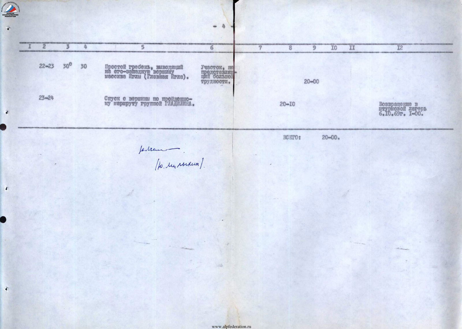
Descend from the ridge left 15 m to a snowy pad, cross the bergschrund, approach under the summit tower of Main Igla.
Ascend from the left side of the ridge 30 m, then up a crevice left-up 40 m. Rocks of the summit tower are tile-like, many «live» rocks (pitons).
Further along a simple rocky ridge — exit to the summit Main Igla.
Descend from the summit in the direction of the east, along snowy fields to a snowy saddle in the Alay Ridge «gates». Then, bypassing the ridge of Malaya Igla via «karniz» Pass to Zeravshan Glacier, along the glacier to Matcha Pass. Return to the assault camp on August 6, 1969, at 1:00.
A summary of the individual sections of the route and the graph of its passage is given in the table.
When assessing the category of difficulty of the route traversed, the group relied on their experience of ascents along classified routes of 4th and 5th category of difficulty.
This route is technically more complex and longer than the traversal of Korona 5A category of difficulty in Ala-Archa. Similar in difficulty to:
- Eastern Shkhelda (via Kropf) — 5A category of difficulty.
- Adyr-Su-bashi from GOLUBEVA Pass — 5A category of difficulty.
Table
Main characteristics of traversing the Igla massif
From Matcha Pass
| Date | Sections traversed | Average steepness in degrees | Vertical extent in meters | By relief character | By technical difficulty | By belay method | Departure time | Time of stop for bivouac | Time of walking hours | Pitons hammered, rappel anchors | Remarks |
|---|---|---|---|---|---|---|---|---|---|---|---|
| 1st day | R0–R1 | 20° | 70 m | Snowy slope from Matcha Pass to the bergschrund | Easy. Simultaneous movement. | 6:00 | |||||
| R1–R2 | 35° | 40 m | Snowy slope after the bergschrund. | Firm snow. | |||||||
| R2–R3 | 35° | 80 m | Snowy ridge leading to the rocky wall. | Medium difficulty. | Via ice axe. | ||||||
| R3–R4 | 65° | 30 m | Rocky wall. At the bottom, a crevice. Ledge. Internal corner with a crevice. Rocks are dusted with snow. | Difficult. | Piton belay. | 5 | |||||
| R4–R5 | 45° | 260 m | Rocky slope with small walls, snow islands and flowstone ice in places. | Medium difficulty. | Via protrusions. | 2 | |||||
| R5–R6 | 20° | 20 m | Traverse to bypass «Paryus» gendarme via a ledge through a couloir with flowstone ice 5 m and again via a 0.5 m wide ledge, dusted with snow, exiting to the ridge. | Medium difficulty. Alternate movement. | Via protrusions and pitons. | 2 | |||||
| R6–R7 | 60° | 60 m | Summit tower of North Peak of Igla massif (Pakharkova Peak). Rocks are large-block, requiring great caution and attention. | Difficult. | Piton and via protrusions. | 10:00 | 3 | ||||
| R7–R8 | 45° | -80 m | Descend along the rocky ridge to the saddle. Rocks are large-block, many «live» rocks, requiring maximum caution when descending. | Medium difficulty. | Via protrusions. | 10:20 | |||||
| R8–R9 | 50° | -50 m | Descend from the saddle left (in direction of travel) to bypass the «gendarme» and bypass it via ledges, exiting to the couloir, which leads to the ridge behind the gendarme. | Sporty descent. | Piton belay. | 2 | |||||
| R9–R10 | 40° | 80 m | Ascend up the right side of the couloir along the boundary between snow and rocks. | Medium difficulty, alternate movement. | Via ice axe and protrusions. | ||||||
| R10–R11 | 60° | 10 m | Wall with destroyed rocks and «live» stones. | Difficult. | Piton belay. | 2 | |||||
| R11–R12 | 50° | 10 m | Icy slope 6 m. Slab 4 m. Exit to the ridge. | Difficult. | Piton belay. | 1 | |||||
| R12–R13 | 45° | 30 m | Snowy ridge transitioning into a snowy slope. | Difficult, firm snow. | Via ice axe and piton. | 1 | |||||
| R13–R14 | 40° | 20 m | Rocky section with snowy islands. Exit to the ridge. | Medium difficulty. Snow is not deep, with ice underneath. | Via protrusions. | ||||||
| R14–R15 | 0° | 0 m | Traverse left 10 m along the wall at the boundary between rocks and ice. | Difficult. Small holds. | Via protrusion. | ||||||
| R15–R16 | 40° | 10 m | Rocky section on the left (in direction of travel) side of the ridge with snow-covered rocks. | Medium difficulty. | Via protrusions. | ||||||
| R16–R17 | up to 45° | 20 m | Steep snowy slope. | Above medium difficulty. | Via ice axe. | ||||||
| R17–R18 | 20° | 20 m | Snowy ridge, with cornices on the left. | Not very difficult section. | Via ice axe. | ||||||
| R18–R19 | 60° | 10 m | Rocky wall leading to the summit of Central Igla. Rocks are monolithic. | Complex. | Piton. | 17:00 | 1 | ||||
| R19–R20 | 30° | -70 m | Descend along the rocky ridge with alternating snowy sections to the saddle of Main Igla. | Medium difficulty. | Via protrusion and ice axe. | 17:30 | |||||
| R20–R21 | 50° | 40 m | Ascend up the left side of the ridge to a ledge. Rocks are heavily destroyed. | Complex. | Piton belay. | 2 | |||||
| R21–R22 | 60° | 30 m | After the ledge, ascend via a sloping crevice left-up. | Complex. | Piton belay. | 3 | |||||
| R22–R23 | 30° | 30 m | Simple ridge leading to the southwest peak of Igla massif (Main Igla). | Not very difficult section. | 20:00 | ||||||
| R23–R24 | Descend from the summit via the route taken by GLADILIN's group. | 20:10 | Return to the assault camp on October 6, 1969, at 1:00. | ||||||||
| TOTAL: | 20:00 |

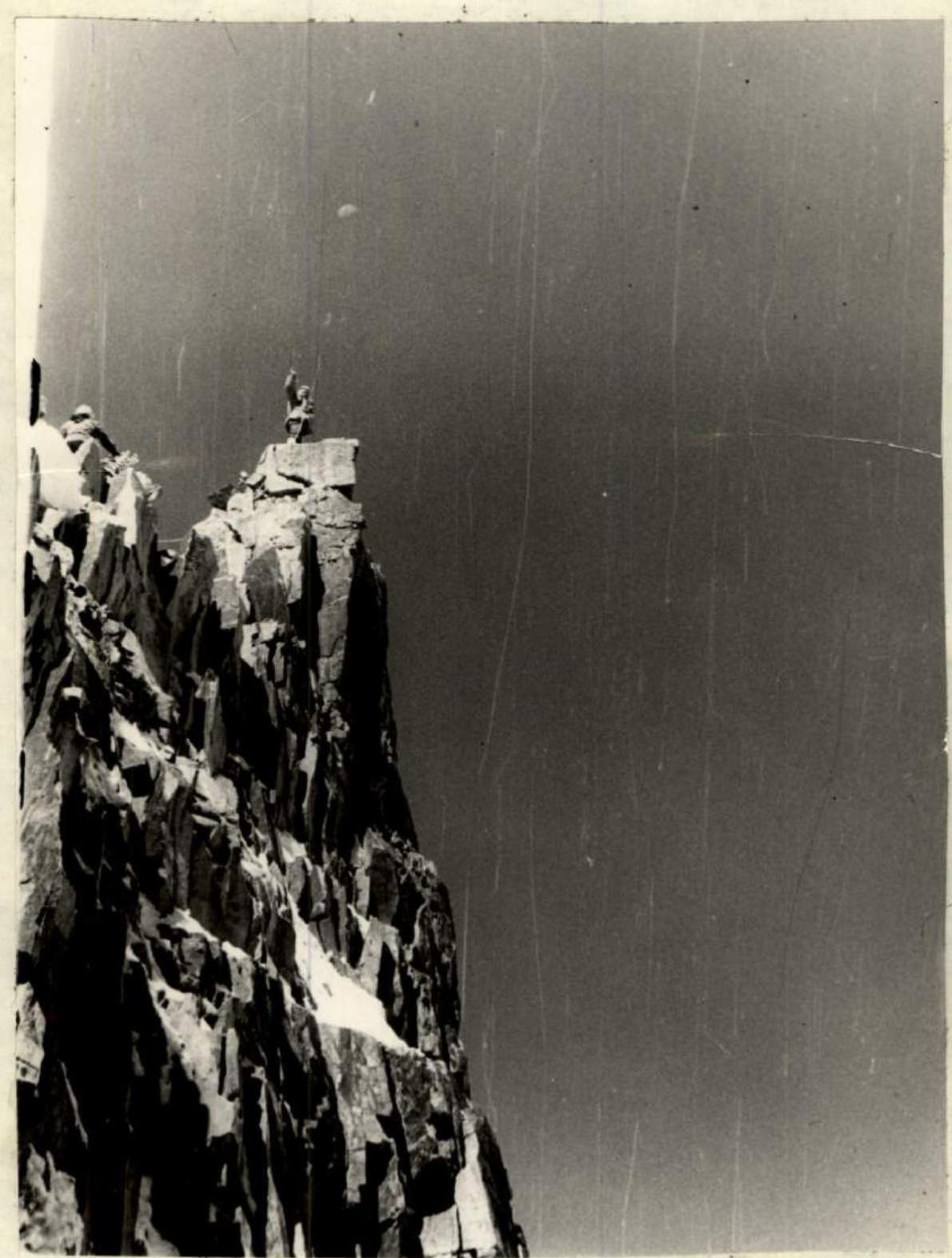 North Peak Igla 4430 m (Pakharkova Peak)