Ascent Passport
- Ascent class - technical.
- Ascent area - Pamir-Alay, Zeravshan Ridge.
- Peak, its height and ascent route - Zamok Peak. H = 5,070 m. Via the E counterfort of the NNE wall. 2nd ascent.
- Estimated difficulty category - 5B.
- Route characteristics: height difference - 970 m, average steepness - 60–70°.
- Pitons driven:
for belaying for creating ITO a) rock - 86 13 b) ice - — — c) bolted - —
- Number of travel hours - 18 h 20 min.
- Number of overnight stays and their characteristics - one overnight stay on a rock ledge, lying down, for two people, not rockfall-prone.
- Full names of participants, their sports qualification Shkarban Viktor Ivanovich 1st sports category Morozov Vyacheslav Valentinovich 1st sports category
- Team coach - Ilyinsky Ervand Tikhonovich
- Date of departure and return:
Departed July 15, 1978 Returned July 16, 1978
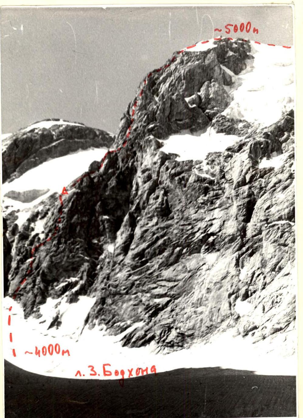
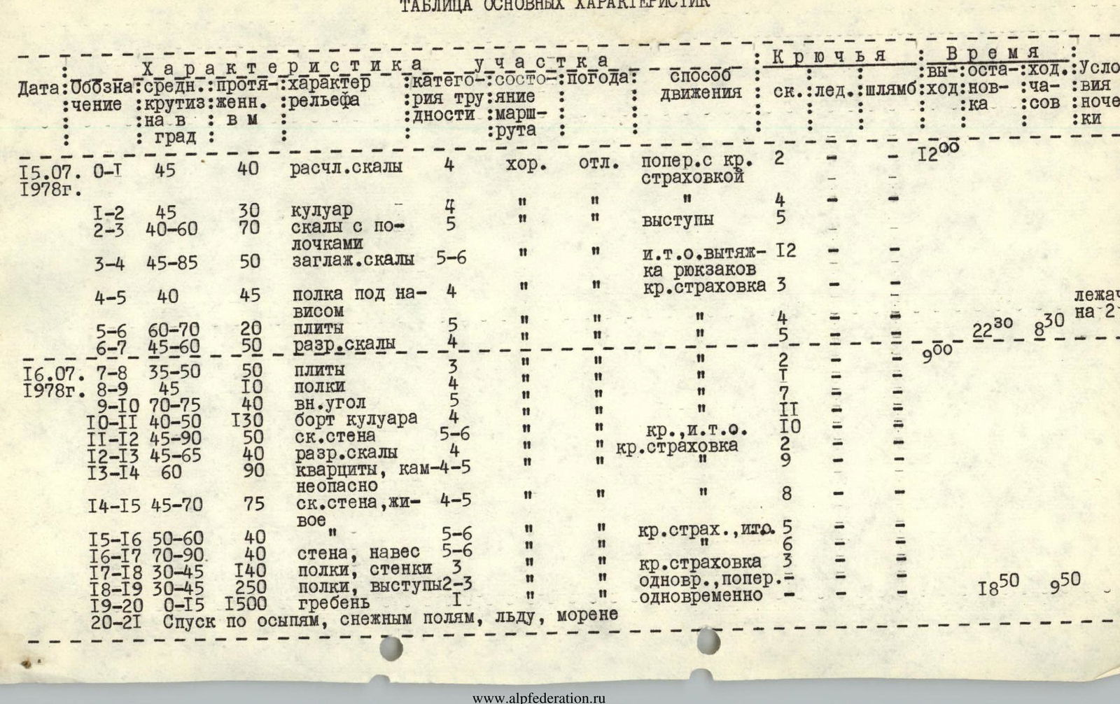
Table of Main Characteristics
| Date | Designation | Avg. steepness (°) | Length (m) | Terrain characteristics | Diff. cat. | Section condition | Weather | Movement method | Pitons (rock) | Pitons (ice) | Pitons (bolted) | Time (travel h:min) | Overnight stays (number) | Overnight stay conditions |
|---|---|---|---|---|---|---|---|---|---|---|---|---|---|---|
| July 15, 1978 | R0–R1 | 45 | 40 | fragmented rocks | 4 | good | excellent | transverse with rope belay | 2 | — | — | 12:00 | — | — |
| R1–R2 | 45 | 30 | couloir | 4 | " | " | " | 4 | — | — | — | — | — | |
| R2–R3 | 40–60 | 70 | rocks with ledges | 5 | " | " | ledges | 5 | — | — | — | — | — | |
| R3–R4 | 45–85 | 50 | smoothed rocks | 5–6 | " | " | ITO, hauling backpacks | 12 | — | — | — | — | — | |
| R4–R5 | 40 | 45 | ledge under an overhang | 4 | " | " | rope belay | 3 | — | — | — | — | lying down | |
| R5–R6 | 60–70 | 20 | slabs | 4 | " | " | " | 4 | — | — | — | — | — | |
| R6–R7 | 45–60 | 50 | shattered rocks | 5 | " | " | " | 5 | — | — | 22:30 | 8:30 | for 2 people | |
| July 16, 1978 | R7–R8 | 35–50 | 50 | slabs | 3 | " | " | " | 2 | — | — | 9:00 | — | — |
| R8–R9 | 45 | 10 | ledges | 4 | " | " | " | 7 | — | — | — | — | — | |
| R9–R10 | 70–75 | 40 | inner corner | 5 | " | " | " | 11 | — | — | — | — | — | |
| R10–R11 | 40–50 | 130 | couloir edge | 4 | " | " | " | 10 | — | — | — | — | — | |
| R11–R12 | 45–90 | 50 | rock wall | 5–6 | " | " | rope ITO | 2 | — | — | — | — | — | |
| R12–R13 | 45–65 | 40 | shattered rocks | 4 | " | " | rope belay | 9 | — | — | — | — | — | |
| R13–R14 | 60 | 90 | quartzites, rockfall-prone | 4–5 | " | " | " | 8 | — | — | — | — | — | |
| R14–R15 | 45–70 | 75 | rock wall, "live" | 4–5 | " | " | " | — | — | — | — | — | — | |
| R15–R16 | 50–60 | 40 | " | 5–6 | " | " | rope belay, ITO | 5 | — | — | — | — | — | |
| R16–R17 | 70–90 | 40 | wall, overhang | 5–6 | " | " | " | 6 | — | — | — | — | — | |
| R17–R18 | 30–45 | 140 | ledges, walls | 3 | " | " | rope belay | 3 | — | — | — | — | — | |
| R18–R19 | 30–45 | 250 | ledges, outcrops | 2–3 | " | " | simultaneous, transverse | — | — | — | — | — | — | |
| R19–R20 | 0–15 | 1500 | ridge | 1 | " | " | simultaneous | — | — | — | 18:50 | 9:50 | — | |
| R20–R21 | Descent via scree, snowfields, ice, moraine |