
Ascent Passport
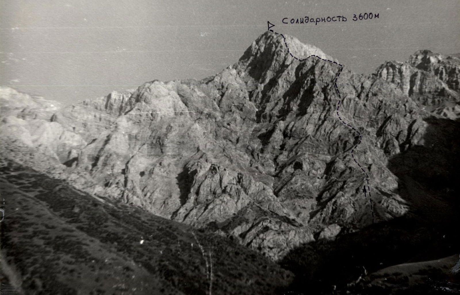
I. Ascent category - rock 2. Ascent area - Western Tian-Shan, Ugam ridge 3. Peak Solidarnosti 3600 m via the counterfort of the Western ridge 4. Proposed category of difficulty - 4B 5. Route characteristics
height difference - 1000 m length of sections with 5–6 category of difficulty - 46 m average steepness - 60°–80°
- Pitons hammered in rock: for belay 25 for creating RPS 4 ice: - number of fixed protection elements used 19
- Number of travel hours 14 hours
- Number of overnight stays none
- Full names of participants, their qualification:
- Rafikov Sh.R. - Master of Sports of the USSR
- Pasanov Sh.R. - 1st sports category
- Team coach - Rafikov Sh.R.
- Date of departure and return June 26, 1985
- Organization - Chimkent Regional Sports Committee
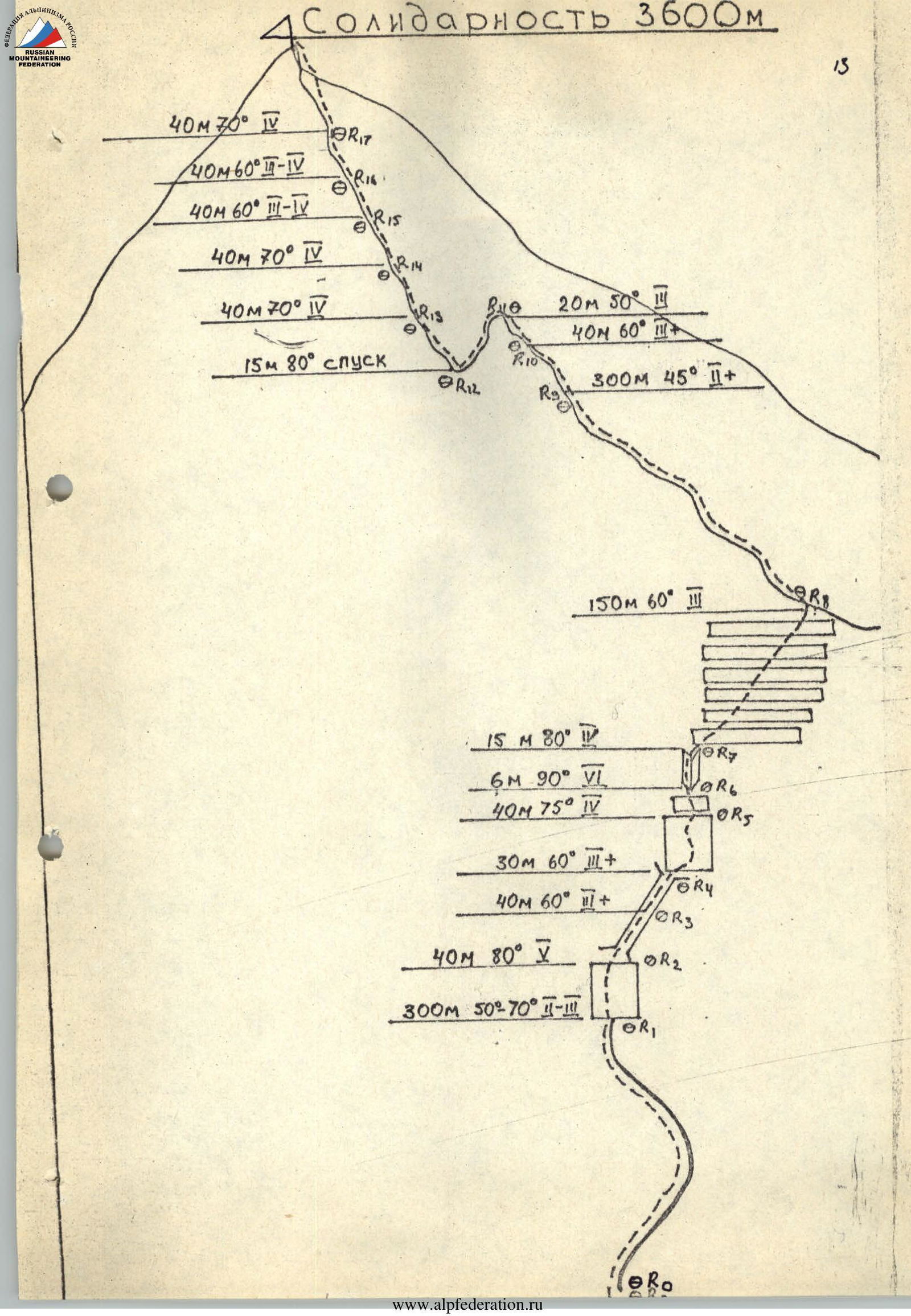
- R0–R1: 300 m, 50°–70°, 2–3 category of difficulty
- R1–R2: 40 m, 80°, 5 category of difficulty
- R2–R3: 40 m, 60°, 2 category of difficulty
- R3–R4: 30 m, 60°, 3 category of difficulty
- R4–R5: 40 m, 75°, 4 category of difficulty
- R5–R6: 6 m, 90°, 6 category of difficulty
- R6–R7: 15 m, 80°, 4 category of difficulty
- R7–R8: 150 m, 60°, 3 category of difficulty
- R8–R9: 300 m, 45°, 2 category of difficulty
- R9–R10: 40 m, 60°, 3 category of difficulty
- R10–R11: 20 m, 50°, 3 category of difficulty
- R11–R12: 15 m, 80° (descent)
- R12–R13: 40 m, 70°, 4 category of difficulty
- R13–R14: 40 m, 70°, 4 category of difficulty
- R14–R15: 40 m, 60°, 3–4 category of difficulty
- R15–R16: 40 m, 60°, 3–4 category of difficulty
- R16–R17: 40 m, 70°, 4 category of difficulty
Brief description of the approach to the route
From the base camp located in the "Burevestnik" clearing, follow a good trail along a nameless gorge to the northwestern slopes of p. Ssolidarnost. The journey takes 1.5–2 hours. Then, first along a grassy slope overgrown with juniper, and then along the talus - exit to the beginning of the route.
Brief explanation of the diagram
Section R0–R1 - rocky ridge. Movement is mostly simultaneous. Belay through ledges and bends. The ridge abuts a rocky bastion of the counterfort. Here is the 1st control point.
The bastion wall is passed on the left side through an overhanging crack. Then comes a flattening and again a rocky wall, leading to the key section of the route - a sheer rocky wall.
There are no cracks for hammering in pitons, and there are practically no handholds. The section is traversed with great tension. Up the inner corner and along the step-like rocks, move up to the right. Exit to the western ridge of p. Ssolidarnost. 6 hours from the start of the route. Attention, there are many loose rocks on the counterfort.
Then, along the 400-meter rocky ridge, ascend to the summit tower of p. Ssolidarnost. The path then follows the rocky edge of the summit tower. Piton belay. 6–8 hours from the exit to the western ridge to the summit. Descent from the summit to the south.