I. Ascent Passport
- Ascent category: Technical
- Ascent area: Shugnan (northwestern spur)
- Peak, its height, and ascent route: p. 5026 (Vir peak) via the E wall
- Estimated category of difficulty: 5B
- Route characteristics:
- Height difference: 1300 m
- Average steepness: E wall 70°
- Length of sections:
- 3rd category of difficulty – 800 m
- 5th category of difficulty – 556 m
- 5th category of difficulty – 344 m
- 6th category of difficulty – 44 m
- Total: 1744 m
- Pitons driven:
- For belaying:
- Chocks: 62
- Rock: 56
- Ice: 1
- Bolt: 3
- For creating ITO (Intermediate Technical Objects):
- Chocks: 2
- Rock: 7
- Ice: —
- Bolt: 2
- For belaying:
- Total travel hours: 19
- Number of bivouacs and their characteristics: one good
- Surname, name, patronymic of participants and their sports qualification:
- Zybin A.N. – 1st category
- Hankevich A.G. – 1st category
- Team coach: MSMK Kavunenko V.D.
- Date of departure and return: July 27, 1978
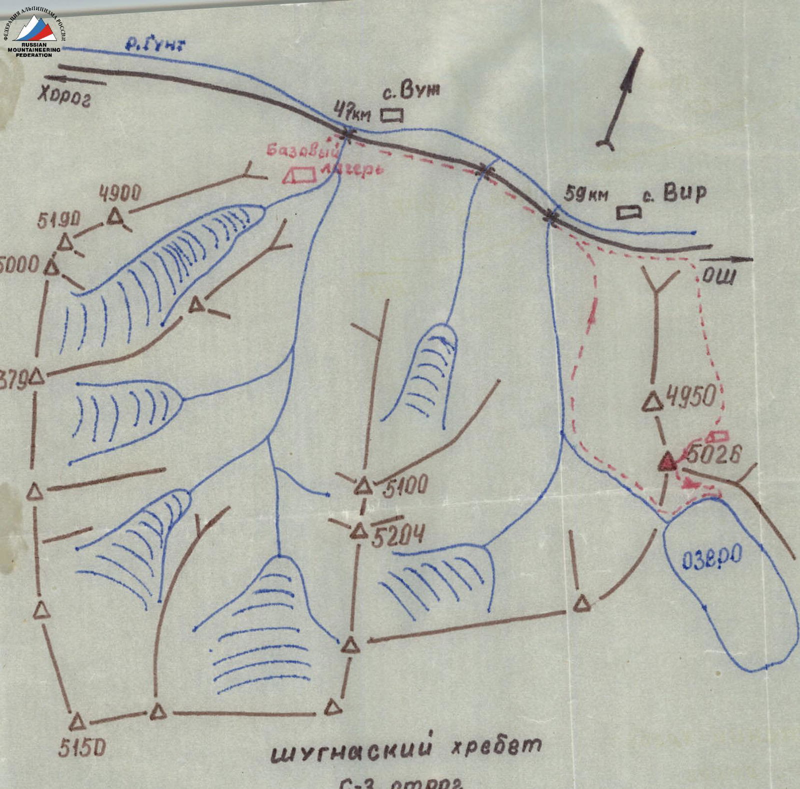
Map-scheme of the ascent area
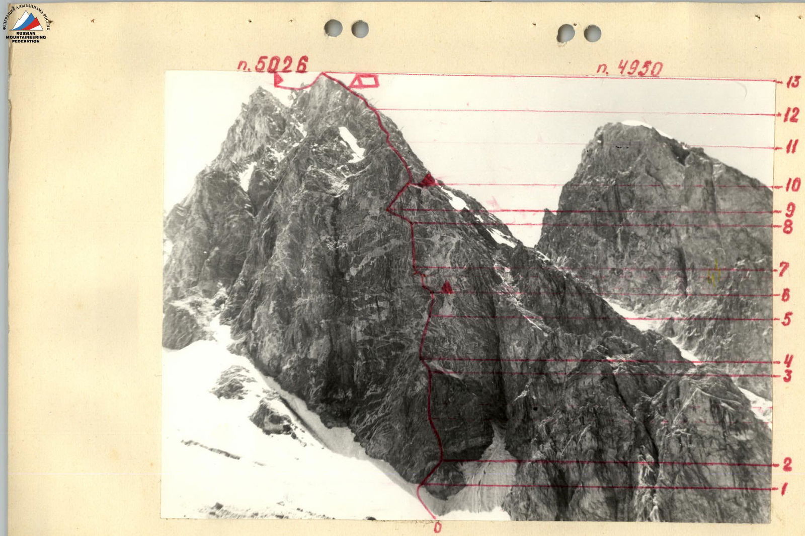
Photo of the general view of the peak
Description of the route to p. 5026 via the E wall
(Explanation to the table)
Approach to the cirque of the p. 5026 glacier from the Osh-Khorog highway (59 km) – 5–6 hours. From the bivouac on the moraine, approach under the wall first along the closed glacier, then along the snow in the direction of the rock "paw" (not visible from the bivouac), section R0–R1. The following should be taken into account:
- To the left of the "paw" are wet rocks, water flows, and stones fall.
- To the right of the "paw" are wet rocks, water flows, and stones fall.
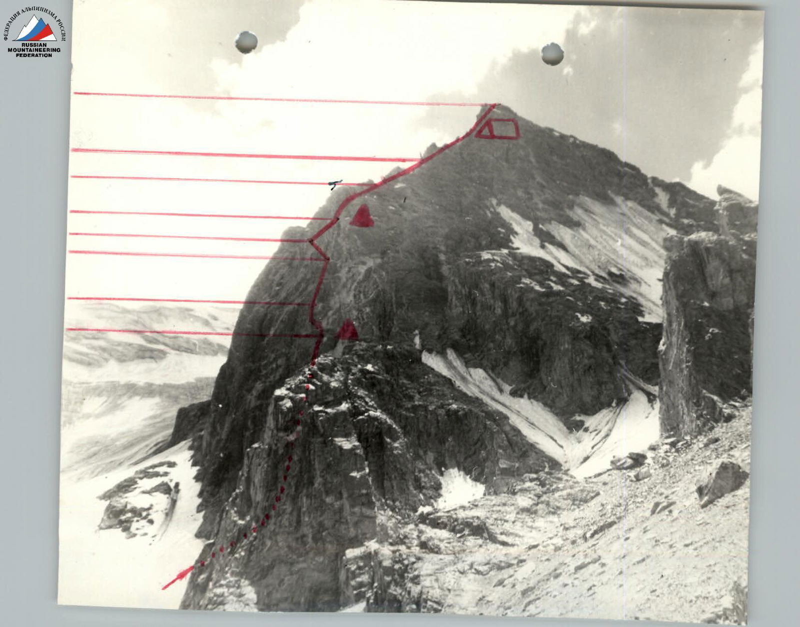
The route begins to the left of the lower extremity of the paw along the wall to the right in the direction of a vaguely expressed rib (R1–R2). Then straight up along the destroyed rocks to a steep snow and ice-filled ledge (R2–R3). Along the edge of wet rocks, exit around the corner along the wall (R3–R4). Along the internal angle of the wall, exit onto the counterfort and up the counterfort under the wall (R4–R5). Up the wall in the direction of the cornice to an inclined ledge with a control cairn (R5–R6). From the control cairn along the internal angle under the cornice. From under the cornice, left around the corner up to a ledge (R6–R7). Then up to the right along the wall (R7–R8). Then traverse left in the direction of the overhanging cornice, which is passed left up along the wall with an exit to a ledge (R8–R9). From the ledge to the right up along an inclined ledge to a site on the ridge (R9–R10). On the site – a control cairn.
The first place on the E wall where an overnight stay in a tent is possible. From the site straight up along the internal angle of the wall and then along the ridge under the Gendarme (R10–R11). The Gendarme is bypassed by traversing to the right along the slabs and then along the ridge to the pre-summit ascent (R11–R12). Along the narrow ridge, exit under the snowfield and then to the false summit (R12–R13). The summit of p. 5026 is located 100 m to the SE from the line of the false summit.
Descent from the summit in the SE direction to the first collapse and then down the snowy slope to the lake. Descent to the lake: 1.5–2 hours. An overnight stay is possible on the summit.
Conclusion on the route
To p. 5026 via the E wall
The route to v.p. 5026 is purely rock. The entire E wall is composed of massive blocks and slabs, interspersed with destroyed rocks.
Route features:
- The route is logical.
- Clearly visible from the glacier under the peak.
- The upper part of the route is visible from the bivouacs on the moraine.
For a group of more than 2 people, it is advisable to initially process the route to the cornice, as there are no good overnight stays and water before the ridge. The route is generally not prone to rockfall. Passing the E wall requires climbers to exert great physical effort, as virtually the entire wall lacks resting platforms, and the rocks are on average 5th category of difficulty. Passing the cornice requires the ability to work on ladders.
The route corresponds to the 5B category of difficulty. The relatively small extent of the wall section (400 m in height) is compensated by the complexity and saturation of difficult sections.
The route is more complex than the routes:
- p. Luknitsky (Nekrasov) – 5B category of difficulty
- Asham via the 1st counterfort (but somewhat shorter)
The team recommends the route for groups with experience in wall ascents.
Table of the main characteristics of the route to p. 5026 via the E wall
| Date | Designation | Length of sections | Avg. steepness | Terrain character | Category of difficulty of sections | Condition | Weather conditions | Pitons (chocks, belay) | Pitons (chocks, ITO) | Pitons (rock, belay) | Pitons (rock, ITO) | Pitons (ice, belay) | Pitons (ice, ITO) | Pitons (bolt, belay) | Pitons (bolt, ITO) |
|---|---|---|---|---|---|---|---|---|---|---|---|---|---|---|---|
| July 27, 1978 | R0–R1 | 100 m | 35° | Snow slope | 3 | Firm snow | Good | — | — | — | — | — | — | — | — |
| R1–R2 | 36 m | 75° | Rock wall | 2 | Destroyed rocks | — | — | — | 2 | — | 4 | — | — | — | |
| R2–R3 | 128 m | 70° | Rock wall | 2 | Destroyed rocks | — | — | — | 5 | — | 2 | — | 11 | — | |
| R3–R4 | 16 m | 50° | Steep ledge | 4 | Wet, destroyed rocks | — | — | — | 2 | — | 1 | — | — | — | |
| R4–R5 | 60 m | 65° | Rock wall | 2 | Destroyed rocks | — | — | — | 6 | — | 4 | — | — | — | |
| R5–R6 | 32 m | 80° | Rock wall | 2 | Monolithic boulders | — | — | 1 | 2 | — | 4 | — | — | — | |
| R6–R7 | 44 m | 90° | Rock wall under cornice | 6 | Monolithic wall | — | 8 | 2 | 10 | 5 | — | — | 3 | 2 | |
| R7–R8 | 56 m | 70° | Rock wall | 2 | Destroyed rocks | — | — | — | 5 | — | 5 | — | — | — | |
| R8–R9 | 32 m | 80° | Rock wall | 2 | Destroyed rocks | — | — | — | 2 | — | 4 | — | — | — | |
| R9–R10 | 40 m | 65° | Inclined ledge | 4 | Destroyed rocks | — | — | — | 1 | — | 3 | — | — | — | |
| R10–R11 | 400 m | 40° | Rocky ridge | 4 | Destroyed rocks | — | 12 | 1 | 4 | — | — | — | — | — | |
| July 28, 1978 | R11–R12 | 300 m | 50° | Gendarme, rock slabs, ledges | 3–4 | Rock slabs, scree ledges | — | 9 | 3 | 1 | — | — | — | — | — |
| R12–R13 | 500 m | 35° | Rocky ridge | 3 | Destroyed rocks | — | 10 | 2 | — | — | — | — | — | — | |
| Total: | 1744 m | 62 | 11 | 56 | 7 | 1 | — | 3 | 2 | ||||||
| including: | 3rd cat. diff. | 800 m | |||||||||||||
| 4th cat. diff. | 556 m | ||||||||||||||
| 5th cat. diff. | 344 m | ||||||||||||||
| 6th cat. diff. | 44 m |