28
Georgian Climbing Club
named after A. B. Japaridze
Class of Traverses
Traverse
Peak "Nablyudeniy" (5579 m) – peak "Fersmana" (5700 m) – peak "Bezimyannyy" (6010 m) – Oshanina massif (6390 m) – peak "30th Anniversary of the Soviet State" (6447 m) – peak "Moskva" (6785 m) – peak "Soyuz-Apollon" (6047 m) – peak "Dushanbe" (5456 m) with ascent to peak "Nablyudeniy" via the southeastern counterfort (first ascent)
Team of the Georgian Climbing Club named after A. Japaridze
Leader: D. Dangadze, Master of Sports
Members:
- G. Abashidze, Master of Sports
- S. Barliani, Candidate for Master of Sports
- Sh. Gabisian, Candidate for Master of Sports
- Sh. Mirianashvili, Master of Sports
Team Coach: Sh. Mirianashvili
§ 1. Brief Geographical Characteristics of the Area
The traverse route passes through the highest peaks of the Central Pamir. The nodal peak of the traverse, peak Moskva, is located at the intersection of the latitudinal ridge of Peter the First and the meridional ridge, on which peak "30th Anniversary of the Soviet State" and the powerful Oshanina massif are situated. Both of these ridges belong to the zone of the Northern Pamir - a young mountain region that began to rise in the Tertiary period and is characterized by:
- powerful glaciation,
- high altitudes above sea level,
- harsh climate with significant precipitation (from 500 to 1000 mm per year).
According to geographers, the Northern Pamir is a humid and cold country.
Many Soviet geographers and climbers have contributed to the study of this region, which plays a huge role in the water basin of the rivers of Central Asia:
- I. Dorofeev (1932–1937),
- Yu. Walter,
- B. Fedchenko,
- D. Tsereteli (1933–1937),
- E. Abalakow,
- V. Lipsky,
- A. Letavet,
- E. Timashev (1947–1949).
§ 2. History of Climbing Development in the Area
Despite the fact that the study of the Sugran glacier basin began as early as the 19th century, the main orographic issues of this region were resolved only in 1947. The first attempt to ascend peak Moskva via the western ridge was made by participants of the expedition led by the well-known Soviet geographer V. Lipsky.
The harsh climate and inaccessibility of the peaks located in the upper reaches of the Sugran and Gando glaciers led to the fact that the conquest of peaks such as Moskva, "30th Anniversary of the Soviet State", Oshanina, "Soyuz-Apollon", Fersmana, and several others was relatively late, and to this day, only a small number of climbers have visited them. Over the past 20 years, only ridge routes have been completed on these peaks.
The section of the Peter the First ridge from peak Dushanbe (5456 m) to peak Moskva and the section of the meridional ridge from peak Moskva to peak Nablyudeniy (5579 m) is extremely challenging in technical terms and has never been traversed in a single route before.
The first ascent of peak "30th Anniversary of the Soviet State" (6447 m) was made by a team of trade unions led by V. Abalakow, who reached the summit from the western cirque via the eastern ridge in 1947.
Under the leadership of D. Oboladze, the first ascent of the western peak of Moskva (6750 m) was made in 1957 via the western ridge.
Under the leadership of I. Bogachev, the first ascent of the Eastern peak of Moskva (6785 m) was made in 1959 via the eastern ridge from the saddle approximately at 5800 m between peaks Moskva and Borodino.
In 1975, participants of the Pamir expedition of the Georgian Climbing Club in the upper reaches of the Sugran glacier made a number of interesting ascents, including first ascents:
- to peak Moskva (6785 m) via the southern ridge (led by D. Dangadze; II place in the high-altitude class at the Union championship);
- to peak "30th Anniversary of the Soviet State" (6447 m) via the northwestern ridge (led by O. Kharazadze);
- to the Eastern Oshanina peak (6390 m) via the eastern ridge (led by Sh. Mirianashvili);
- to peak Dushanbe (5456 m) via the western ridge (led by V. Rybinsky);
- to peak "Soyuz-Apollon" (6047 m).
In the same year, 1975, a group of climbers from the Moscow Sports Committee, while traversing peak Moskva – peak Communism, ascended peak Moskva from the Gando glacier side, reaching the southern ridge of the massif at around 6400 m (led by V. Vanin).
In 1974, a group of climbers from the GDR made the first ascent of peak Fersmana (5700 m) via the western snow-ice ridge.
A successful traverse was made by Belarusian climbers in 1975 from Shini-Bini to peak Moskva (led by Lazovsky). The climbers first traversed the three peaks of Oshanina in a technically complex manner but were forced to abandon the route due to bad weather.
No other ascents to the peaks in the area were recorded (except for the ascent to peak Moskva via the eastern ridge in 1969).
In applications for participation in national championships, the traverse of peak Moskva – peak Oshanina was mentioned several times, and our team had also applied in 1975.
In preparation for the ascent in the Sugran-Gando area, the Georgian Climbing Club team thoroughly studied the materials of previous expeditions, conducted detailed reconnaissance, and identified possible objects for ascent:
- the eastern wall of peak Moskva,
- traversing the entire Sugran horseshoe from peak Nablyudeniy to peak Dushanbe in a single route, considering this a necessary and natural step in the climbing development of the area.
The traverse route, which is much more complex than the Shini-Bini – peak Moskva traverse, included several unconquered peaks, including those above 6000 m, and was planned to start with the ascent to peak Nablyudeniy via the southeastern counterfort.
§ 3. Climbing Conditions in the Traverse Area
The 1976 expedition team of the Georgian Climbing Club has experience climbing in this region of the Pamir. In 1972, members of the assault group ascended peaks E. Korzhenevskaya and Communism. In 1973, they ascended peak E. Korzhenevskaya via the southeastern wall (II place in the high-altitude class).
The 1975 expedition was particularly significant, as it was conducted in harsh climatic conditions and included ascents to:
- peak Oshanina (eastern peak),
- peak "30th Anniversary of the Soviet State",
- peak Moskva via the southern ridge (II place in the high-altitude class),
which provided the team with a thorough understanding of the climbing conditions in this unique corner of the Pamir and the orography of the area as a whole.
Years of experience from Pamir expeditions have shown that stable good weather usually occurs in years following harsh winters and significant summer precipitation. Weather forecasts for the summer of 1976 were partially correct. Bad weather affected the route's terrain, resulting in complex snow and firn slopes with sections of powdery snow.
Since this area is one of the most inaccessible in the Pamir, organizing an expedition without a helicopter is impossible. Cargo was airlifted to the assault camp, requiring careful packing in:
- metal tanks,
- sturdy wooden crates.
From the assault camp, located on the right-bank terrace of the Sugran glacier (4350 m), the path to the traverse route goes along the moraine and the exposed part of the Nablyudeniy glacier (2.5–3 hours).
§ 4. Organization of the Expedition and Ascent
The decision to participate in the 1976 USSR Climbing Championship was made by the Presidium of the Georgian SSR Climbing Federation in autumn 1975.
The Georgian SSR Climbing Federation and the Georgian Climbing Club took a serious approach to forming a national team and preparing for the future expedition. A plan for team preparation and expedition was approved in full. Team training was conducted under the systematic control of the Georgian SSR Climbing Federation and Sports Committee.
The national team, focused on high-altitude ascents and traverses, was trained under the guidance of senior coach Sh. Mirianashvili. Since the core of the team consisted of climbers from the "Burevestnik" Sports Society (Tbilisi State University), all training and preparatory work was concentrated at the sports club of Tbilisi State University. Control over the team's physical preparation was entrusted to Honored Coach of the Georgian SSR N. Kankava.
The Georgian Climbing Club (Director D. Oboladze) conducted extensive preparatory work, culminating in the arrival of the expedition at the base camp in the Sugran valley (2670 m) on July 15, 1976.
Group and personal equipment for the expedition was newly manufactured by the Georgian Climbing Club, with a focus on minimizing weight. Significant assistance in organizing the expedition, including the organization of base and assault camps and the delivery of supplies and equipment, was provided by the Dushanbe United Air Squadron.
§ 5. Team Preparation for the Ascent
The foundation of physical and technical preparation was regular year-round training. In Tbilisi, this included cross-country running, climbing rocks in Tsavkisi and Armazi, and short-term (3–7 days) trips to mountain areas like Chauhi and Khde.
In autumn, training focused on developing endurance, with parallel rock climbing sessions. Climbing volume in a single training session reached 350–400 meters vertically, using:
- ladders,
- free climbing,
- practicing rope descent techniques.
From October 1 to 15, 1975, team members (except Sh. Gabisian) participated in a gathering organized by the RS SDO "Burevestnik" in the Khde valley and, as instructors, completed ascents.
From March 15 to 31, the entire expedition team gathered for training in Bakuriani. Team members participated in at least five competitions of various ranks, including long-distance events.
During the harsh winter of 1975–1976, team members, like other climbers in the republic, were mobilized to assist populations in mountain areas affected by natural disasters.
Spring was marked by intense training. To gain high-altitude acclimatization, the entire team gathered for training in Terskol. From April 25 to May 10, team members ascended the Elbrus saddle three times from the II shelter, with overnight stays on the saddle.
In late June, two sports groups, including expedition members, ascended the Shkheldaltar peak via a 5A category route.
On July 15, the expedition gathered at the base camp. Only O. Kharazadze was absent due to his wife's serious illness.
The training cycle also included all outings in the Pamir preceding the main route:
- The first outing from the assault camp (4350 m) to deliver supplies and some equipment to the saddle between the eastern peak of Oshanina and peak "30th Anniversary of the Soviet State" (5600 m).
- The second outing to the saddle between peaks Nablyudeniy and Fersmana (5300 m).
§ 6. Tactical Plan for the Ascent
The plan involved organizing a base camp (2650 m) and an assault camp using a helicopter from the Dushanbe United Air Squadron. However, due to the lack of a suitable landing site in the upper reaches of the Sugran glacier, only members of the main group were airlifted to the assault camp one by one. Critical cargo was also delivered by helicopter. Other cargo was parachuted into the assault camp. The journey from the base camp to the assault camp took two days.
The object of the ascent - traversing the large Sugran horseshoe from peak Nablyudeniy to peak Dushanbe - was chosen based on multiple preliminary reconnaissance missions, considering the team's experience and preparation, as well as the level achieved by Soviet climbers in this class of ascents.
Key parameters of the traverse:
- altitude up to 6785 m (7 peaks out of 11 above 6000 m),
- technical complexity of rock walls and corniced ridges,
- significant total altitude difference,
- extreme length (approximately 18 km in a straight line),
predetermined the complexity of developing a tactical plan for the ascent. It was necessary to improve technical and material support, apply rational movement and belay schemes, and rethink high-altitude equipment.
The concept of autonomous movement by linked pairs, with the use of "perils" and "link-by-link" movement in exceptional cases, was adopted due to the equal capability of the pairs and climbers within them. Good acclimatization allowed the team to maintain a high pace of movement on various terrain forms at all altitudes of the traverse.
Reducing backpack weight (to no more than 12 kg) was achieved through:
- high-quality equipment,
- calorie-rich food,
- careful selection of personal, group, and special equipment.
The lead climber on the ascent and the last on the descent carried lighter backpacks (by 3–5 kg), further accelerating the overall pace.
Equipment was lightweight, durable, and warm, specially manufactured to meet the team's needs. All team members wore high-altitude boots with Vibram soles (imported).
Provisions, some equipment, and fuel were airlifted to key points on the traverse (saddle at 5600 m between the eastern peak of Oshanina and peak "30th Anniversary of the Soviet State", and between peaks Nablyudeniy and Fersmana at 5300 m).
The movement regime maximized daylight hours. Long stops for rest and snacks were avoided on the route; everything was done on the move. Excellent knowledge of the route and warm equipment allowed the group to move even in low visibility.
Nutrition was hot and twice a day, with "dry rations" issued for the day. Each team member had a liter flask with warm tea and orange juice solution. The food set was high-calorie, weighing 400–450 grams per person per day.
Tactical techniques for specific route sections were determined by ensuring maximum safety and were as diverse as the terrain forms on the route.
Ascent Plan by Days
1st day. Assault camp (4350 m) – traverse of the southeastern counterfort of peak Nablyudeniy (overnight at the saddle before peak Fersmana).
2nd day. Traverse of the western ice-rock slope of peak Fersmana, reaching the pre-summit southern ridge (overnight at or near the summit or on the saddle between peaks Fersmana and "6010").
3rd day. Traverse of the southern snow-rock ridge of the unnamed peak 6010 (overnight on the snow ridge before the summit).
4th day. Ascent to peak 6010, followed by a traverse to the western peak of Oshanina.
5th-7th days. Traverse of the three peaks of Oshanina, descending from the eastern peak to the 5600 m saddle.
8th-9th days. Traverse of the "30th Anniversary of the Soviet State" massif.
10th-12th days. Ascent to peak Moskva via the western snow-ice slope, reaching the western counterfort near 6550 m.
13th-14th days. Descent from peak Moskva via the southern ridge to the Letavet pass, traversing peak "Soyuz-Apollon" (a high-altitude ascent route taken by our team in the 1975 season).
15th day. Ascent to peak Dushanbe via the northern ridge, followed by descent via the western snow-ice ridge to the Sugran glacier (overnight at the assault camp).
16th-18th days. Reserve for bad weather.
The plan was to complete the route in 15 days, but it was ultimately completed in 17 days due to unforeseen bad weather on the most technically challenging section.
§ 7. Safety Measures
Ensuring the safety of the ascent was the top priority, guiding all aspects, including preliminary training, route study, tactical planning, medical support, equipment, and nutrition.
Before the season, all team members underwent medical examinations. In the mountains, all outings were preceded by medical checks.
The team had a high-altitude medical kit, and each participant carried a personal first-aid kit.
Prevention of altitude sickness and fatigue was achieved through:
- vitaminization,
- intake of methionine,
- intake of calcium gluconate.
§ 9. Ascent Chronicle
1st day – July 26
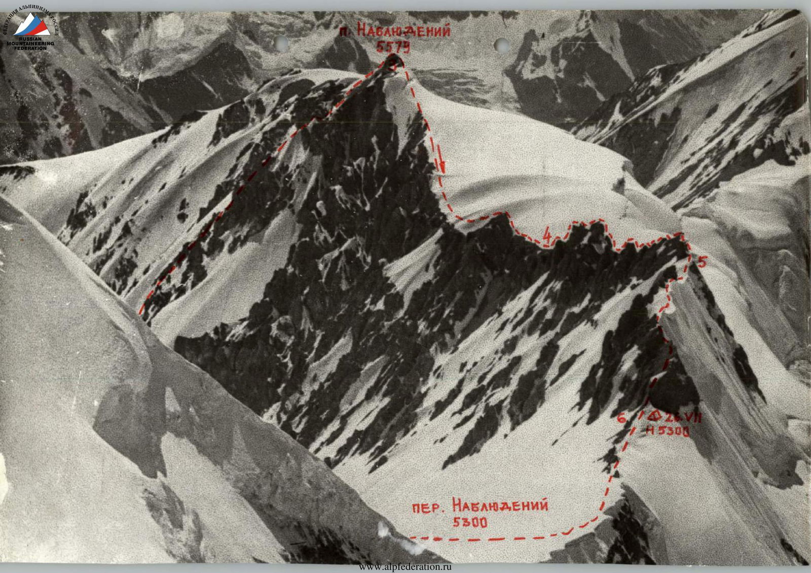
The team departed from the assault camp (4350 m) at 7:00 AM. They initially followed the moraine and then the left edge (orographic) of the Nablyudeniy glacier. After about an hour, they reached the middle, snowy step of the glacier and began ascending a gentle snow slope towards the southeastern counterfort of peak Nablyudeniy. The group took 2 hours and 30 minutes to reach the base of the counterfort.
The southeastern counterfort of peak Nablyudeniy is characterized by alternating rock and snow ascents of moderate difficulty. The average steepness is under 45°, and the vertical extent is 800–850 m. The rocks are heavily destroyed. The first pair to ascend was Sh. Gabisian – D. Dangadze. The group took 7 hours to traverse the counterfort.
The descent from the summit towards the Nablyudeniy pass involved initially following a gentle snow ridge, transitioning into a complex, destroyed rock ridge with numerous gendarmes. The height of some rock walls reached 25–30 m. The group spent 6 hours on this section, using piton and rock outcrop belays. They camped on the Nablyudeniy pass at the base of the last rock gendarme.
2nd day – July 27, 1976
The team departed from the bivouac at 8:00 AM. From the Nablyudeniy pass, they encountered a steep ice slope (55–60°) and 300–350 m long, transitioning into the summit ridge of peak Fersmana. Upon reaching the lowest point of the pass, they began traversing the western slope of peak Fersmana, using the base of a rock counterfort as a guide. They overcame an ice ledge and a steep snow-ice slope (up to 60°) to reach the rocks. Further ascent involved a steep snow slope (45–50°) and 90 m long towards the southern edge of the summit. As they ascended, the snow cover depth decreased, requiring step-kicking in the ice. Above, they encountered a snow-ice slope 200 m long and 40–45° steep. After the first two ropes, where snow on ice was sufficient for ice axe belays, they began using ice screws. A total of 7 ice screws were used on this section. The southern rock ridge to the summit (120–130 m, 35–40°) was relatively straightforward. They stopped for the night at 18:45.
3rd day – July 28
The team departed from the bivouac at 9:00 AM. Traversing the pre-summit snow-ice slope led them to steep rocks on the summit tower. The rocks were approximately 65° steep. After two ropes of good climbing, they moved slightly to the right, crossing an ice couloir, and reached a steep rock gully (20–25 m, 50°). At the top of the gully, they encountered a slight overhang. The ascent to the summit followed a steep snow slope (12:30 PM).
In the summit cairn, they found a note from GDR climbers who made the first ascent of peak Fersmana via the western snow-ice ascent in 1974, rating the route as category 4.
Their route via the western slope to the southern pre-summit shoulder was significantly more complex and interesting.
The descent from peak Fersmana to the north, towards the unnamed peak at 6010 m, was challenging, involving rock and ice ledges. The weather was excellent.
They began descending via a steep snow slope (120–130 m, 60–65°) to avoid rock and ice ledges. The snow was deep, often up to the waist. Belays were made using ice axes.
The descent to the saddle took 1.5 hours.
The ascent to peak "6010" involved a mixed-type ridge with destroyed rocks, firn, and ice. In the upper part, the firn-ice cover became more challenging, requiring constant belays using ice axes and, in places, piton belays.
They camped on the ridge at an altitude of 5850 m.
4th day – July 29
The weather deteriorated overnight, with snow, wind, and fog. The team departed from the bivouac at 10:00 AM. A steep snow-ice ascent (45–50°) followed, with alternating movement and belays using ice axes and pitons. The ridge then became snowy. Visibility was 20–25 m, with snow falling and strong gusts of wind. The ascent character remained unchanged. By 13:00, the pre-summit rocks became visible. They reached the summit of peak "6010" at 14:00, marking the first ascent. The route complexity was rated 5B.
Bad weather forced them to set up a bivouac early, at 14:30, on a snow ridge leading to peak Oshanina (Western peak). The route to peak "25th Party Congress" via peak Fersmana is undoubtedly category 5.
5th day – July 30
Strong winds and snowfall continued throughout the night and morning. Visibility was 5–7 m. The team departed from the bivouac at 11:00 AM, as the snowfall temporarily ceased and the fog partially cleared. They found themselves on the correct path. A gentle snow ridge led them towards the western peak of Oshanina. Within an hour, they reached the lowest point of the ridge at 6000 m.
The ascent to the western peak of Oshanina was along a sharp snow-rock ridge. Movement was mostly alternating, with belays using ice axes and rock outcrops. The upper part of the ridge featured deep, fresh snow. At 14:00, they reached the western peak in fog and snowfall. In the cairn, they found a note from Moscow "Burevestnik" climbers dated July 18, 1976, who were traversing peak Oshanina – peak Moskva.
They decided to descend a couple of ropes and wait out the bad weather. They set up a tent and contacted the assault camp via radio.
The weather did not improve, with heavy snowfall and strong gusts of wind.
6th day – July 31
A snowstorm continued, and they had to periodically clear the tent of heavy snowfall. Forced rest day. It significantly cooled down, feeling like winter had arrived in the mountains.
The weather cleared overnight.
7th day – August 1
After three days of bad weather, a significant amount of loose snow had accumulated. The team departed from the bivouac at 8:00 AM. The ridge between the western and central peaks was heavily serrated, with numerous rock gendarmes, towers, and complex cornices. They had to navigate through challenging snow conditions.
The day was spent overcoming gendarmes on the ridge. The detour around gendarmes was complicated by unreliable snow. At 21:00, they stopped for the night on the summit of the last gendarme before the central peak's rock tower.
8th day – August 2, 1976
The team departed from the bivouac at 8:00 AM. Immediately after the gendarme, they encountered the central peak's summit tower (180–200 m, 70–75°), featuring icy rocks with sections of loose snow. They traversed the tower using complex climbing techniques and hook belays. At 21:00, they reached the summit of the Central Oshanina. They found a note from Moscow "Burevestnik" climbers dated July 20, 1976.
The descent from the Central peak to the Eastern peak followed steep, snowy, and destroyed rocks (100–190 m, 45–50°). They camped on a snowy traverse at 21:45.
9th day – August 3
The team departed from the bivouac at 8:30 AM. The ridge between the Central and Eastern peaks presented no significant challenges. They traversed below the ridge, avoiding technical difficulties. The Eastern peak featured three complex rock towers. They bypassed the first two towers via a complex traverse from the south, using hook belays. The third rock ascent was taken head-on, involving very difficult climbing (60°, 65–70 m).
In the cairn, they found a note from V. Khomutov's group. After the summit, they descended to a snowy terrace, where they organized a bivouac.
10th day – August 4
The weather deteriorated overnight, with snowfall, wind, and fog, resulting in zero visibility. The team only managed to descend to the saddle (to their cache) that day, taking 2.5 hours of climbing time.
11th day – August 5
Due to bad weather, they departed from the bivouac at 11:30 AM. The northwest ridge of peak "30th Anniversary of the Soviet State" featured numerous gendarmes in its lower section. The route was familiar from the previous year's ascent by Sh. Gabisian.
Strong winds hindered movement. They camped at 15:00, having climbed 200–250 meters vertically.
12th day – August 6
The weather was ideal, and it was cold. They departed from the bivouac at 9:30 AM. The middle section of the ridge was mostly snow-ice with numerous cornices. Belays were made using ice axes and rock pitons. The ridge allowed for simultaneous movement in places. A key section was the passage of a rock step with a нависающим cornice (at the top of the ridge). They camped on a sloping snow terrace 50 meters from the ridge.
13th day – August 7, 1976
The team departed from the bivouac at 8:30 AM. The ridge featured numerous cornices. They traversed below the ridge, avoiding steep sections. The final 500–600 meters to the control cairn were relatively straightforward.
In the cairn, they found a note from V. Khomutov's group. The descent to the northwest ridge of peak Moskva was uneventful. They camped below the saddle on a snowy terrace.
14th day – August 8
The team decided to change their preliminary plan to ascend peak Moskva via the northwest ridge, which had been completed by a Moscow "Burevestnik" group. Instead, they opted for a more challenging route up the center of the steep western slope, exiting onto the western ridge at around 6500–6600 m.
They departed from the bivouac at 7:00 AM. The weather was excellent. They began traversing the snow-ice slope towards a rock ridge. The steepness gradually increased. The snow was deep and loose, requiring trench digging in places. By midday, they reached the base of a rock counterfort descending from the western ridge. The section was 50–55° steep on average, with short, steeper sections (70–75°). The rocks were snowy and icy, making climbing very difficult. Belays were primarily made using rock pitons. At 18:50, they reached the ridge.
The western ridge at around 6500 m was serrated and featured complex rock gendarmes, most of which were bypassed using difficult climbing and hook belays from the south. They camped at 20:30 at the base of a large gendarme on a snowy ridge.
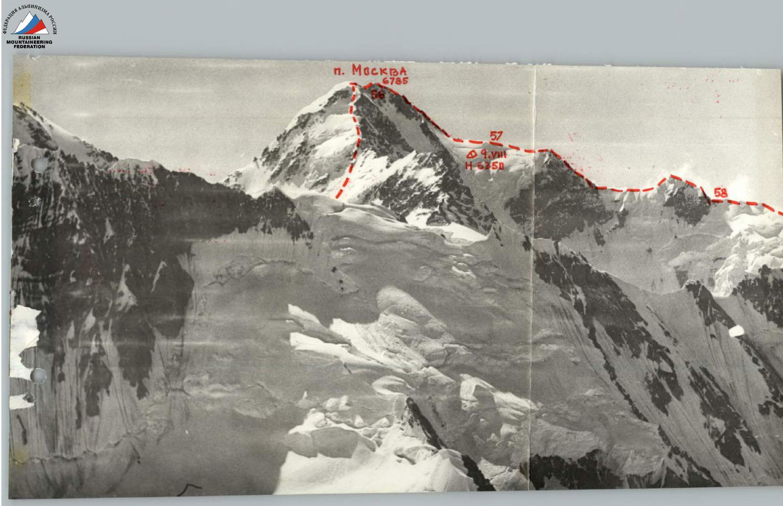
15th day – August 9
The weather was excellent. The team departed from the bivouac at 10:00 AM. They ascended a steep snow slope to bypass a large rock gendarme. Further ascent involved a steep firn slope. The movement was alternating, with belays using ice axes. They quickly gained altitude as the steepness decreased. The pre-summit and summit snow ascents were straightforward. At 13:00, they reached the western peak of peak Moskva.
The saddle between the western and eastern peaks featured a ridge with snowy cornices and small rock gendarmes. The height difference was negligible (35–50 m). At 13:45, they reached the main eastern peak of peak Moskva. In the cairn, they found a note from Moscow "Burevestnik" climbers.
At 14:30, they began descending towards the southern ridge. Their descent route coincided with their previous year's ascent route via peak "Soyuz-Apollon" (6047 m). Using sport climbing techniques and rappelling, they reached the upper snow shoulder of the southern ridge by 20:00 and camped.
16th day – August 10
The weather was excellent. The team departed from the bivouac at 8:00 AM. To reach peak "Soyuz-Apollon", they had to traverse two large rock basins and a serrated snow-ice ridge with cornices. The descent was primarily done using sport climbing techniques. Darkness caught up with them on the complex corniced ridge near peak "Soyuz-Apollon". The full moon provided sufficient light. At 24:00, they reached the pre-summit of peak 6047 m and camped.
17th day – August 11, 1976
The weather was excellent. The team departed from the bivouac at 7:00 AM. They descended from peak "Soyuz-Apollon" via the southern snow-ice slope (average steepness 40°). At 14:00, they reached the Letavet pass.
The snow ridge between peaks "Soyuz-Apollon" and Dushanbe was straightforward. They traversed the eastern slope, following the destroyed rocks and talus, to reach the start of the northern ridge of peak Dushanbe (5456 m). The average steepness of the ridge was 40–45°. The ascent route followed the junction of snow and rocks, with some steeper (10–15 m) ice sections. The route complexity was rated 4A-4B.
At 17:20, they reached the summit. The descent followed the western snow ridge, a familiar route from the previous year's ascent. The average steepness was around 35°. At 20:30, they reached the Sugran glacier opposite their assault camp, completing the traverse of the large Sugran horseshoe.
§ 10. List of Food Products and Equipment
The nutrition plan was based on the principle that the weight of a daily ration for one participant should not exceed 450 grams, with a calorie content corresponding to 400 calories. The selection of food products prioritized items that improve appetite and cater to individual tastes without compromising necessary calorie content.
List of Products
- Specially prepared meat (beef) - basturma.
- Salted pork fat.
- "Servelat" hard-smoked sausage (Finland).
- Grain caviar.
Composition of the Sports Team
Captions on Photographs
5300 m
www.alpfederation.ru
P. Agapiev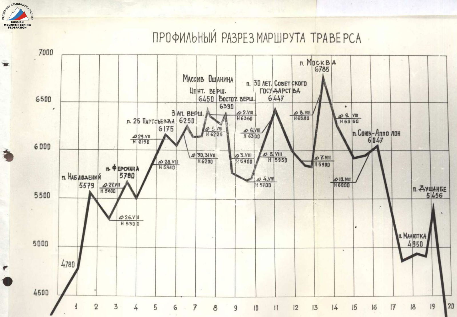
Profile Cross-Section of the Traverse Route
Note:
- Ascent to peak Nablyudeniy via the southeastern counterfort (first ascent).
- Ascent to peak Fersmana and peak "25th Party Congress" via the southern ridge (first ascent).
- Ascent to peak Moskva via the western slope with exit onto the western ridge (first ascent).
- Ascent to peak Dushanbe via the northern ridge (first ascent).
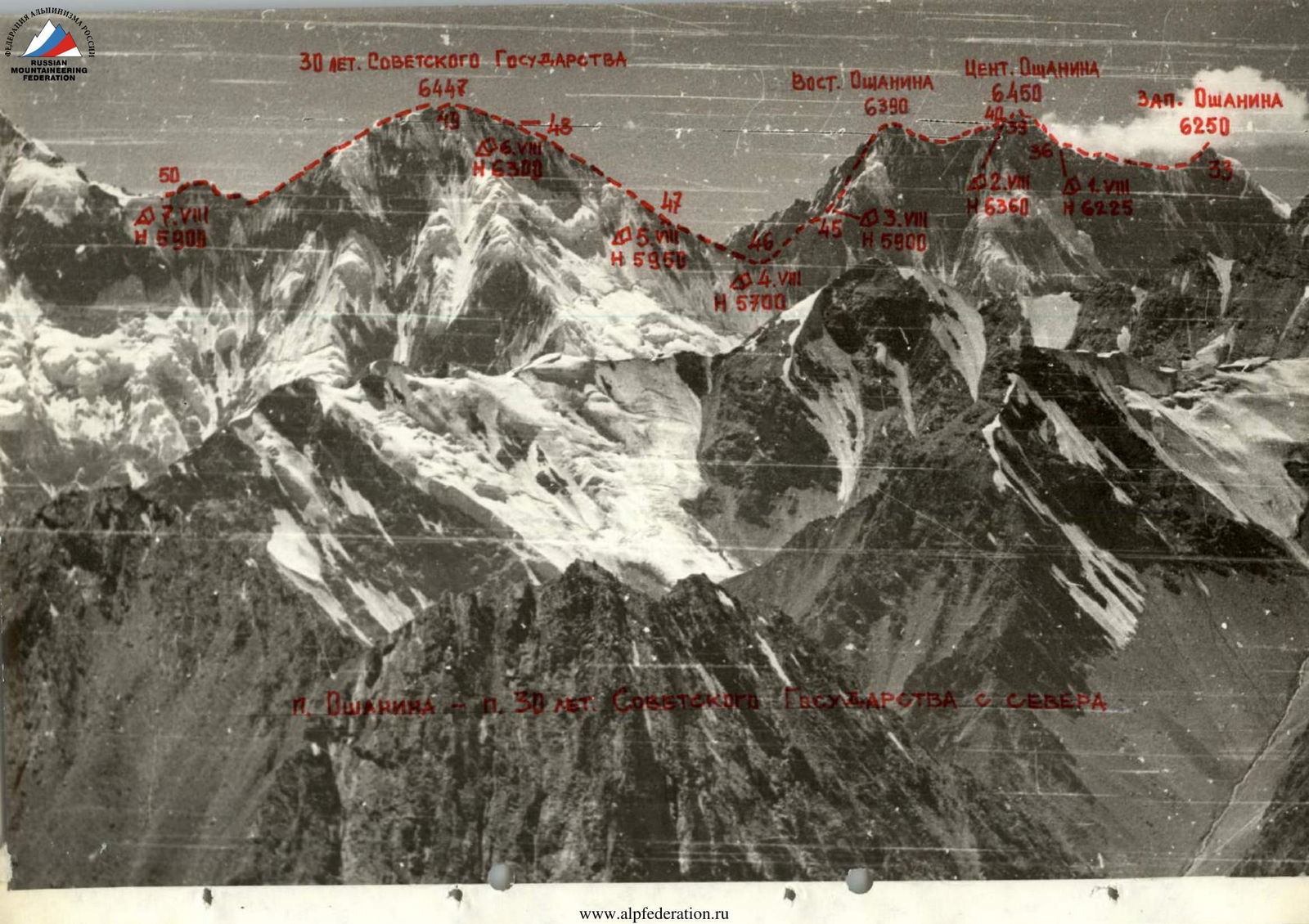
30th Anniversary of the Soviet State – Western Oshanina
6447
Western Oshanina 6390
Central Oshanina 6390
2nd Western Oshanina 6350
II. Obzornoye 5751
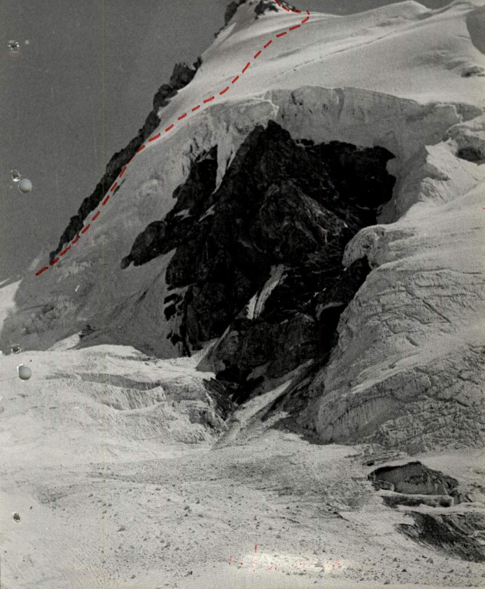
Table of Main Characteristics of the Traverse Route. Route 2: Traverse Peak Nablyudeniy – Peak Dushanbe
| Date of Passage | Sections Passed | Average Steepness | Length (m) | Terrain Characteristics | Category of Difficulty | Method of Passage and Belays | Weather Conditions and Time of Bivouac | Number of Pitons (Rock) | Number of Pitons (Ice) | Bivouac Conditions | Notes |
|---|---|---|---|---|---|---|---|---|---|---|---|
| July 26, 1976 | R0–R1 | 40° | 320 | Snow ascent with rocky outcrops | Medium difficulty | Simultaneous movement in links | Clear, windless. Departure at 7:00 | – | – | – | |
| R1–R2 | 50° | 130 | Steep rocky ascent, suitable for climbing | Above medium difficulty | Alternating movement, piton belays | –"– | 5 | – | – | ||
| R2–R3 | 45° | 700 | Steep snow ridge with rocky sections, partly icy | Above medium difficulty | Alternating movement, belays through ice axes | –"– | 1 | – | – | ||
| R3–R4 | 15–20° | 700 | Snowy, rocky ridge | Simple ridge, easy rocks | Simultaneous movement in links | –"– | – | – | – | ||
| R4–R5 | – | 300 | Sharp rocky ridge with numerous gendarmes, height 5–25 m | Rocks, category 4 | Alternating movement, piton belays and through outcrops | –"– | 11 | – | – | ||
| R5–R6 | – | 300 | Snow-rock ridge – Nablyudeniy pass | Above medium difficulty | Alternating movement, belays through ice axes and pitons | Clear, windless. Bivouac 21:30–14:30 | 1 | – | Bivouac on Nablyudeniy pass 5300 m | ||
| July 27, 1976 | R6–R7 | 45° | 400 | Traverse of western snowy slope of peak Fersmana | Medium difficulty | Simultaneous movement in links | Clear, windless. Departure at 8:00 | – | – | – | Loss of 50 m vertically during traverse |
| R7–R8 | 50° | 65 | Bergschrund, steep snow-ice drop | Difficult section | Alternating movement, belay through ice axe | –"– | – | – | – | ||
 | |||||||||||
| R8–R9 | 60° | 60 | Steep ice slope | Difficult section, step-kicking | Belays through pitons | Clear, windless | – | 2 | – | ||
| R9–R10 | 50° |