Ascent Log
- Ascent classification: high-altitude technical
- Ascent area: Northwest Pamir, Walter Glacier
- Ascent route with indication of peaks and their heights:
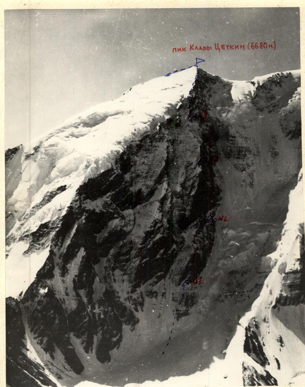
West wall of Peak Klara Zetkin, 6680 m.
- Characteristics of the ascent: height difference 2280 m, average steepness 73°, length of complex section 834 m
- Number of pitons: rock 253
ice 13, expansion bolts 2
- Number of travel hours: 83 h
- Number of bivouacs and their characteristics: seven (five semi-reclining, two reclining).
- Team name: Armed Forces of the USSR.
- Surname, name, patronymic of team leader, participants, and their sports qualification:
Popenko Yuri Stepanovich MS, Afanasyev Vladimir Mikhailovich MS, Lobanov Sergey Dmitrievich MS, Polnov Vladimir Georgievich MS, Staroselets Evgeny Vasilyevich MS, Aigistov Gleb Alexandrovich CMS, Zolotarev Vladimir Pavlovich CMS, Solomatov Boris Stepanovich CMS. Team coach: Ilyinsky Ervant Tikhonovich, Honored Coach of the Kazakh SSR, MS. 11. Dates of departure and return: July 18, 1976 — July 26, 1976.
1. Characteristics of the Area and Ascent Conditions
The Northwest Pamir region, where Peak Klara Zetkin (6680 m) is located, is characterized by significant uplift of mountain ranges and is home to two nearby seven-thousanders, Peak Kommunizma and Peak E. Korzhenevskoi (7105 m). Apparently, the presence of these giants, which drew the attention of arriving climbers, overshadowed Peak K. Zetkin with its virtually sheer western walls until a certain time.
In mountaineering terms, the Northwest Pamir region (the cluster of Fortambek, Walter, and Moskvina glaciers) has a rich history associated primarily with the conquest of seven-thousanders, which began with A. Ugarov's ascent of Peak Korzhenevskoi in 1953. The first ascent of Peak Kommunizma in this region was made in 1968.
The area is frequently visited by climbers, despite the difficulty of approaching it. This has become possible due to the recent use of helicopters for delivering people and cargo to the area. Since 1972, an international mountaineering camp "Pamir" has been based on the Fortambek Glacier.
Only recently, when almost all options for ascents on Peaks Kommunizma and E. Korzhenevskoi were exhausted, did climbers turn their attention to the steep walls of lower-altitude peaks. Among them, Peak K. Zetkin took the first place (photos 1, 2, 3).
The ascent via the western wall of Peak K. Zetkin was considered problematic due to the tactical and high technical complexity of the route. During the ascent, this was confirmed. The difficulty of the route was exacerbated by specific relief features and weather conditions. These conditions include:
- The route's significant steepness, close to sheer in the middle part of the wall with heavily fragmented rocks, which sharply increased the complexity of the route, requiring special caution when moving along the route and the application of tactical and technical techniques dictated by the conditions:
- the need to use belays almost throughout the entire route for participant movement;
- pulling up backpacks for a total distance of over 300 m;
- using galoshes on rocky sections for climbing, which allowed, in some cases on very complex terrain, to avoid using expansion bolt techniques;
- using ladders in some cases for climbing.
- The presence of ice crust and depth frost on rocks covered with snow in the upper part of the wall made the rocks slippery, concealed holds and cracks, thereby increasing the difficulty of the rocky terrain.
- Late illumination of the wall by the sun (12:00–12:30), which is so necessary during cold morning hours, dictated the need for relatively late departures from bivouacs, especially under the conditions of a sharp cold snap that occurred on July 23.
- Unstable weather during the ascent period, starting from July 23, complicated the already technically challenging ascent.
- The lack of convenient places for organizing bivouacs along most of the route: out of five, only two were organized relatively quickly (1.5–2 hours). More time was required for the others. To this was added the need to prepare platforms for two tents since the ascent was carried out with a full team (8 people).
- The presence of rockfall zones at the beginning of the route forced the team to work during early hours (from 4:00 to 12:00) to avoid being caught in rockfall when descending to the Walter Glacier camp.
The relatively quick passage of the wall (8 days, 83 hours) was largely facilitated by:
- correctly chosen movement tactics;
- good physical and technical preparedness of the participants;
- the use of galoshes on complex rocky sections for climbing (climbing in high-altitude boots would have been seriously hindered).
2. Preparation for the Ascent
2.1. Choosing the Ascent Route
The object of the ascent — Peak K. Zetkin was chosen on the recommendation and with the direct participation of the team's coach, MS, Honored Coach of the Kazakh SSR Ilyinsky E. T.
In preparation for the upcoming qualifying ascent, the team underwent a 20-day training session in "Ala-Archa".
6. Route Description
July 15 — the group consisting of V. Afanasyev, V. Polnov, B. Solomatov, and G. Aigistov departs from the base camp at the confluence of the Walter and Moskvina glaciers at 15:00 to conduct preliminary processing of the start of the route on the western wall of Peak K. Zetkin.
The ascent initially follows a randleff along the right orographic side of the Walter Glacier, then transitions to a slope of the MFPT peak. After 2.5 hours, they reach the location for observers, where a tent is already set up for them.
From the observation point, it takes another 2 travel hours to reach the initial bivouac site, from where the route processing will begin. The path to it lies along the glacier, bypassing lateral crevasses in the upper reaches of the Walter Glacier. The initial bivouac site is chosen on a talus slope descending from a ridge between the MFPT and K. Zetkin peaks. The site is:
- safe, protected from rockfall by a rock outcrop;
- warm;
- near water.
July 16 — the first day of route processing. At 4:00, the pair V. Polnov – B. Solomatov departs from the camp. Initially, they move along the glacier, then along a firn slope with a steepness of 50–55° to the left of the ice debris cone that periodically falls to the right of the western wall of Peak K. Zetkin. The pair reaches the bergschrund, which is the starting point of the route, in 30 minutes. The upper ice edge of the bergschrund is 2.5 m above the lower one (section R0–R1). The bergschrund is traversed with a boost. Then, the ascent continues straight up the ice slope with a steepness of 65° on crampons towards a rocky outcrop (section R0–R1). Under the rocky outcrop, they make a sharp turn and traverse a 65° ice-firn slope for 30 m towards a rocky massif (section R1–R2). The ascent up the rocky massif begins with a 10-meter wall with a steepness of 80–90° directly upwards, broken by slates (section R2–R3, photo 3a). Further, they move along a rocky wall with a steepness of about 70° and a length of 190 m, composed of gray slate in horizontal layers (section R2–R3). The slate is very brittle, easily breaking and crumbling. Although the rocky terrain has average difficulty, the unreliability of the rock at such steepness significantly complicates climbing, adding considerable psychological strain. On the rocky section, the first climber wears galoshes. Belay is ensured by driving rock pitons, mostly of large length (200–250 mm), sometimes through rock outcrops. However, as the wall begins to be hit by oblique sun rays, the time approaches 12:00 — all taken ropes are hung. It is necessary to start descending to avoid being caught in the rockfall zone below the bergschrund.
In 7.5 hours, a 290-meter section of the route was processed (eight belay ropes were hung). The weather throughout the day was good.
July 17. The pair V. Afanasyev – G. Aigistov departs from the camp at 5:30 to continue processing. By 8:00, they had covered the section processed the day before. Yesterday's pair had approached a 20-meter wall of the first rocky bastion with a steepness of 80–90° and a small number of cracks, which is traversed with difficult climbing, trying not to use expansion bolt techniques. Today, this wall is overcome on the right (section R3–R4). Then, they move left onto the edge of the rocky bastion with a steepness of 60° and along it for 4 m under a 4-meter sheer rocky wall (section R3–R4). The wall consists of monolithic blocks stacked on top of each other. When driving pitons between them, the blocks start to shift.
After the 4-meter wall, the movement continues along a monolithic slab with a steepness of 45° and a length of 7 m, on which stones lie freely (section R4–R5). From the slab, they move left onto an array of "red" rocks, representing a chaotic jumble of stone blocks with a steepness of 60°. Movement is along its right side for 33 m (section R4–R5).
The array of "red" rocks ends with a short internal angle, above which is an inclined snow shelf.
At 11:30, the pair begins their descent. In the morning, there was cloudiness, and a light snow fell. In the second half of the day, it cleared up. By 18:00, the rest of the ascent team arrives at the forward quartet from the main camp. Now, the entire team is gathered at the initial camp, ready to assault the western wall of Peak Klara Zetkin.
July 18. Departure at 6:00. The processed section of the route, 370 m long, is traversed. The last belay point is located on a sloping shelf measuring 0.5 × 0.5 m, one edge of which is buried in the rock below the inclined snow shelf.
From the belay point, the path goes along a sheer internal angle for 4 m with heavily fragmented rocks. Further:
- Exit onto an inclined snow shelf, which leads to the next sheer internal angle, 20 m long, wide at the bottom and sharply narrowing towards the top, where it abuts a rocky cornice (section R5–R6, photo 4).
- From the angle, move right onto a smooth slab with a width of 2.5 m and a steepness of 40°.
- Along the slab, bypassing a rocky outcrop on the right that overhangs the slab, exit onto a square, 1 × 1 m, horizontal rocky shelf.
- From the shelf, the path continues for 5 m along a vaguely expressed sheer internal angle, turning into a narrow chimney 10 m high with smooth sheer walls.
- Exit from the chimney is made using ladders.
Backpacks on the section were pulled up (section R5–R6, photo 5).
Above the chimney is an inclined talus shelf covered with snow and ice. From it upwards — a rocky groove with a steepness of 70°, abutting a sheer wall. Movement goes first 10 m along the groove, and then along its left side, which is a sheer rocky wall made of weathered rocks with an intricate pattern (section R6–R7, photo 6).
Further, the wall becomes less steep to 80° and over a 20-meter section represents destroyed black rocks (section R6–R7).
Then, there is a 10-meter wall with a steepness of 85° made of destroyed rocks. And again — 30 m of destroyed rocks with a steepness of 75°, composed of black slate (section R7–R8). From the rocks, move left for one rope length along a snow-ice slope with rocky outcrops with a steepness of 70°. Traverse at an angle of 45° to a group of protruding stones (section R8–R9). The traverse continues another 20 m along snow covering ice-hardened stones (section R9–R10), after which the ascent begins 20 m straight up along a rocky-ice slope with a steepness of 70° (section R9–R10) with an exit under a rocky ridge with a snow cushion at its base. A comfortable reclining bivouac is organized on the cushion. The exit to the cushion is late on this day — at 20:00. At 21:00, they made contact, exchanging information with the observers.
The sky was gloomy in the morning, and a light snow was falling, but then the weather improved, although clouds continued to crawl across the sky throughout the day. Towards the evening, around 21:00, fog rolled in. The sunset was rosy, with clouds on the west standing higher than the sun setting below the horizon, which foretold good weather for the next day.
Today, the pair V. Afanasyev – G. Aigistov worked ahead. The last one and a half ropes (60 m) were traversed first by S. Lobanov. July 19. Today, the pair S. Lobanov – E. Staroselets works ahead. The path goes along a rocky, heavily destroyed ridge with a steepness of 60° and несложным рельефом. In some places, rocks give way to firn. Movement goes along the right slope of the ridge; then again, there are outcrops of simple rocks, and beyond them — a firn slope of the same steepness, gradually turning into a rocky slope with a stepped structure. The ridge is eroded and abuts a sheer rocky wall. Movement goes alternately with belay through pitons, outcrops, and ice axe. The length of the traversed section is about 200 m (section R10–R11). Then, a 30-meter traverse is made to the right and upwards at an angle of 60° along a slab of черепичного строения, which is bounded on the left by a sheer wall (section R11–R12). On the last 10 m, we bypass a rocky outcrop along destroyed rocks and enter the upper reaches of a rocky couloir with many freely lying small stones (section R11–R12). The belay point is organized in a niche of a sheer wall, protected from possible falling stones thrown down by the ropes of the preceding participants.
To continue the ascent, it is necessary to cross the couloir and move left and upwards along destroyed rocks of medium difficulty with many freely lying stones (section R12–R13). Movement is very cautious with thorough piton belay.
Along the wall, the ascent goes 15 m up a narrow chimney with a steepness of 85°, then 25 m along slabs of черепичного строения with a steepness of 70° with a limited number of holds and cracks for driving pitons (section R13–R14, photo 7). We try to avoid using expansion bolt techniques.
From the slabs, we turn left and enter a niche where a belay point is organized. From the niche, we traverse 20 m along the wall with a steepness of 80° (section R13–R14) with a descent onto an inclined wide shelf, where two tents were set up at different levels. For one of them, it was necessary to lay out a platform from stones with a height of the front wall of about 1.2 m.
The exit onto the shelf occurred at 16:00. The weather throughout the day was simply magnificent. July 20. The first day of processing the rocky overhang. Departure of the trio B. Solomatov – V. Polnov – E. Staroselets at 10:30. From the bivouac, the ascent goes 10 m up along destroyed rocks with a steepness of 70° under a sheer 10-meter wall with a vertical slit, which leads to a shelf. Along the shelf, movement continues with a traverse to the right at an angle of 20° along a wall overhanging with a cornice for 35 m (photo 8). The wall "pushes" off the shelf. Climbing is difficult. At the end of the shelf, move upwards 5 m along a sheer wall with heavily destroyed rocks (section R15–R16).
Again, a traverse under the overhanging wall to the right and upwards for 15 m at an angle of 30° (section R16–R17). The wall is gray with vertical yellow marble veins. Entry into an internal angle, the right side of which is a smooth slab with a steepness of 70° and a length of 10 m, the left side is a sheer drop. Movement goes along the slab on friction (section R16–R17, photo 9). The internal angle ends with a sheer 15-meter wall of черепичного строения with a limited number of holds and cracks (section R16–R17, photo 9). The first climber ascends with free climbing in galoshes. Above the wall is a "balcony". From the "balcony" along a rocky shelf with "live" stones along a sheer wall, the ascent continues at an angle of 45° to the right and upwards for 20 m to a narrow internal angle (section R17–R18) with smooth walls, having variable steepness: at the bottom 70°, at the top up to 90°. Movement along the internal angle continues straight upwards for another 20 m (section R17–R18). Climbing is done on распорах "back-legs". The angle "pushes out" the climber, making it very difficult. At the top, it abuts a one-and-a-half-meter cornice, to the right of which there is a ledge for organizing a belay point (section R17–R18, photo 10). From the ledge, move right 5 m along a slab with a steepness of 70° without cracks or holds. Climbing is very difficult, in galoshes. Constantly, one has to decide whether to drive expansion bolt pitons and use stirrups or climb with free climbing. More often, preference is given to the latter.
After exiting from under the cornice, the ascent continues 15 m along a wall with a steepness of 80° to the right and upwards at an angle of 50° (section R18–R19, photo 11). The wall is composed of brittle, heavily destroyed rocks. It is followed by a sheer 8-meter smooth wall without holds, which is traversed to the right and upwards at an angle of 60° from the horizontal with very difficult climbing using ladders (section R18–R19). The latter leads to a wall with a steepness of 80° with a narrow inclined shelf along overhanging rocks, which is interrupted in the middle by a smooth, as if polished, slab (section R18–R19, photo 12). The wall has many yellow-white horizontally located veins, resembling a "zebra" in appearance. The ascent along it goes to the right and upwards for 12 m at an angle of 45°. For organizing belay, due to the lack of cracks, an expansion bolt piton was driven at the end of the section, to which the belay rope was attached (section R18–R19).
This concluded the processing of the rocky overhang on the first day at 17:30. The first participant climbed in galoshes throughout the day because the weather was favorable: warm and sunny. July 21. Processing continues at 9:30 with the pair Popenko – V. Zolotarev. In an hour and a half, they cover the section processed the day before. At 11:00, the pair begins working on a new section. From the belay point, movement continues to the right and upwards for 5 m at an angle of 60° along a steep (70–80°) rocky wall with a limited number of holds of erosional origin (section R19–R20).
Further, the steepness of the wall increases to 85–90° for 35 m, with heavily destroyed rocks (section R19–R20, photo 12A). At the end of the section, there is a rocky overhang. Under it, they move to the right and upwards for 5 m along rocks of stepped structure and ascend vertically for 5 m along a slit in the wall with a steepness of 85–90°, exiting onto a vaguely expressed shelf. From the shelf, along a sheer wall with a small number of holds, they move steeply to the right and upwards for another 5 m. Again, a semblance of a shelf. From it, 7 m along a slab with a steepness of 60°, and entry into a wet angle. From the angle, to the right — exit onto a smooth, sheer, местами onвисшую wall composed of different rocks (forming a kind of "layered pie"), which is traversed using ladders (section R20–R21, photo 13). To organize belay, another expansion bolt piton had to be driven. The wall ends with a large, крутонаклонной shelf.
On the shelf at 18:00, the processing of the rocky overhang was completed. The pair covered 80 m of the most difficult rocks in 7 hours. Climbing was done in galoshes. Following the first pair, at 18:00, the second pair — V. Afanasyev – S. Lobanov — departed, who threw above the equipment and supplies not needed at the moment to facilitate the passage of the processed section of the route by the group the next day, representing great difficulty.
The weather starts to deteriorate in the second half of the day. The ridge, from Peak Kommunizma to Peak K. Zetkin, is shrouded. At 16:00, snow falls intermittently. At times, the sun breaks through the veil of clouds and scorches intensely. Icefalls rumble from the firn plateau more frequently today. Apparently, the ongoing warming affects the regime of hanging glaciers. At 17:30, sleet falls again, and the sun shines. Towards the evening, the northwest is covered by black clouds. Peak E. Korzhenevskoi is also obscured by them. Bad weather surrounds us from all sides. The storm warning, which we were informed about by radio yesterday, begins to be confirmed. July 22. Departure from bivouac № 2 at 9:00. Throughout the day, the section processed on July 20–21 was traversed — 260 m.
Backpacks had to be pulled up almost throughout the entire processed section. Only at 20:00 did the first participant — S. Lobanov — reach the base of a giant internal angle, where bivouac № 3 was organized, for which he had to traverse 40 m along rocks of stepped structure with a steepness of 70° (section R21–R22). The last participant reached bivouac № 3 only at 22:00. The day was physically very tense.
Only one tent could be set up on a snowy ridge, the second had to be hung, and the team had to make do with a sitting bivouac, although even in the tent that was standing, it was possible to arrange only a semi-reclining position. July 23. Departure of the first pair, V. Polnov – S. Lobanov, from the bivouac at 9:30. Movement began with an ascent of 10 m along a slate slab with freely lying stones (section R22–R23). Above the slab lies a wall with a steepness of 85° and a length of 70 m, composed of slate blocks with many "live" stones. Slate is местами пронизаны quartz veins.
The wall is the beginning of the right контрфорса, framing the giant internal angle (section R23–R24, photos 14, 15), and ends with a крутонаклонной talus shelf.
From the shelf, the path goes 20 m to the left of the internal angle (section R24–R25, photo 16) with a subsequent transition to a 20-meter rocky wall with a steepness of 75–85° (section R24–R25). After it, move to the right and upwards at an angle of 40° along a rocky massif, first 5 m along rocks of medium difficulty, and then 35 m along a rocky shelf covered with small debris, exiting under a 2-meter yellow-gray wall, at the base of which lies an inclined smooth rocky shelf measuring 2 × 5 m (section R25–R26). The yellow-gray wall is overcome head-on with a boost. It is followed by 10 m of rocks with a steepness of 85°, as if eaten away by smallpox, and transitioning into an internal angle, at the base of which there is a turn to the right with a move onto a 25-meter rocky wall of мелкоблочного строения (section R26–R27, photo 17). The wall ends with a talus shelf with a width of 1.5–2 m and a length of 10 m. Movement is all the time under the overhang of the rocky massif wall.
The pair takes in the ropes and continues the ascent, and on the shelf, bivouac № 4 is organized. From the shelf, 10 m of rocks of перьевидного строения with a steepness of 80° are traversed, then again 30 m along a rocky shelf at an angle of 40°, covered with small debris (section R27–R28), and on the last 5 m — covered with snow.
Having passed these 5 m, we exit onto a wall with snow-covered rocks with a steepness of 80–85° and a length of 15 m. At the end of the rocks, there is a steep turn to the left onto a плиту черепицеобразного строения of the same steepness with a length of 45 m (section R28–R29). Further, there is a rocky relief of 22 m, representing an alternation of narrow shelves with 3–4-meter smooth sheer walls at an overall steepness of 75–85° (section R29–R30). The walls are in some cases traversed with a boost. Above lies a rocky couloir, narrow at the bottom and expanding upwards. The lower part of the couloir has a steepness of 85° for 8 m and is covered with ice (section R29–R30). On both sides, the couloir is framed by rocky walls with sections of ice and snow. Exiting the narrow part of the couloir, we turn to the right and continue movement along a rocky wall 25 m long, covered with snow, with a steepness of 85° (section R29–R30) to a rocky ridge.
The passage of this section was completed by the first climber by 20:00, after which the pair descended to the bivouac site. At bivouac № 4, it was necessary again to build stone walls with a height of up to 0.5–0.8 m — the bivouac turned out to be semi-reclining.
As a result, about 360 m were traversed during the day, of which 160 m processed today will be included in the active part of the next day.
The weather throughout the day was warm but foggy. A short, sparse snowfall occurred. Fog rolled in from below, and at times, the sun shone through the gaps. The night was cold and starry, and the next morning was frosty. The bivouac height already exceeds 5600 m. July 24. The first pair, S. Lobanov – E. Staroselets, departs on the route at 9:00. By 10:30, they have traversed the sections processed the day before and begin working on laying a new path.
Movement goes 5 m along a rocky ridge with a steepness of 70°, and then 15 m along steep snow-covered rocks of the same steepness (section R31–R32). And again, a 60-meter rocky ridge with a steepness of 70° with snow and ice (section R31–R32). The ridge turns into a wall 60 m long with the same steepness, covered with snow and ice, ending in a hardened slope (section R32–R33), which extends for 100 m and leads under steep snow-covered rocks (section R33–R34). The steepness of the rocky wall along which the further path lies is 70° for 80 m (section R34–R35). Rocks under the snow are covered with depth frost, and cracks are filled with ice. Due to visible supports being hidden under snow, and ice and frost on rocks, climbing is significantly complicated. Above, the slope steepness decreases to 60° over a 40-meter section with individual small rocks protruding (section R35–R36). Further, a traverse of this slope is made to the left for 20 m (section R36–R37) with a subsequent ascent of 20 m along a rocky wall with a steepness of 80°, composed of blocks in the form of smooth slabs and covered with loose snow (section R36–R37). It is followed by a rocky wall of черепицеобразного строения made of thin, brittle slate with a steepness of 85° and a length of 40 m (section R37–R38). Again, a rocky wall 120 m long, covered with snow, with rocks made of slate and a steepness of 75° (section R38–R39). This concludes the current working day. The first climber reached a site near the snow-rocky ridge, convenient for organizing a bivouac, at 20:00. The site is a snow mulde adjacent on one side to a large stone. After a short preparation, the platforms were ready, and tents were quickly set up, despite a strong wind and cold. The height exceeds 6000 m.
The weather throughout the day was sunny but with a constant strong cold wind blowing snow dust into faces. Towards the evening, the wind and cold intensified. Throughout the night, gusts of wind violently tore at the tent. The end of the extreme tent, which formed a pocket where it met the slope, was completely filled with snow by morning. The night did not provide rest, and it was very cold. July 25. Despite an early rise, departure was late — at 12:00 due to strong winds. At 15:15, the team reached the summit of Peak Klara Zetkin, where they found a note left by Uzbek climbers (led by Khorechko), who had traversed Peaks Kommunizma – E. Korzhenevskoi in 1975.
The path to the summit, about 400 m long, followed a snow-ice-rocky ridge with an average steepness of 50–55° (section R39–R40). Movement was:
- simultaneous with belay through outcrops or ice axe;
- местами попеременно with belay through pitons.
At 15:30, the descent from the summit began towards the saddle between Peaks Klara Zetkin and Akhmedi Donisha, which they reached at 18:00. Bivouac № 6 was set up in a mulde under a large stone, on the wall of which a note from K. Kuzmin and V. Bozhukov was found, who had traversed Peaks Kommunizma and E. Korzhenevskoi in 1968 but abandoned the traverse after receiving news of V. Suloev's death.
The cold snap was felt here as well, despite the lower altitude. July 26. At 12:30, the descent from the saddle onto the Moskvina Glacier began, and 8.5 hours later, the group in full stood on the glacier in its upper reaches, where bivouac № 7 was organized (another one was on the descent). During the descent from the saddle, it was necessary to hang a rope three times with subsequent pulling through. July 27. At 8:00, we were awakened by the voices of assistants who had arrived in the upper reaches of the Moskvina Glacier to meet us. Departing at 9:30, by 11:00, everyone had благополучно reached the base camp.
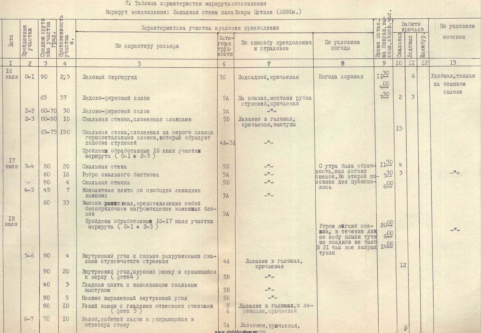
| Date | Traversed Sections | Average Steepness of Section, ° | Section Length, m | Terrain Characteristics | Difficulty Category | Method of Overcoming and Belay | Weather Conditions | Departure Time, Bivouac Stop, Travel Hours | Number of Pitons Driven (Rock) | Number of Pitons Driven (Ice) | Number of Pitons Driven (Expansion Bolts) | Bivouac Conditions |
|---|---|---|---|---|---|---|---|---|---|---|---|---|
| July 16 | R0–R1 | 90 | 2.5 | Ice bergschrund | 5Б | Boosting, piton belay | Weather good | 11:30 | 6 | Comfortable, warm on talus slope | ||
| R0–R1 | 65 | 57 | Ice-firn slope | 5А | On crampons, step cutting, piton belay | 7:20 | 2 | 3 | ||||
| R1–R2 | 60–70 | 30 | Ice-firn slope | 5А | -"- | |||||||
| R2–R3 | 80–90 | 10 | Rocky wall composed of slates | 5Б | Climbing in galoshes, piton belay, outcrops | 15 | ||||||
| R2–R3 | 65–75 | 190 | Rocky wall composed of gray slate in horizontal layers forming step-like structures | 4А–5А | -"- | |||||||
| July 17 | R3–R4 | 80 | 20 | Rocky wall | 5Б | -"- | Morning cloudiness, light snow. Cleared in the second half of the day | 11:20 | 4 | |||
| 60 | 16 | Edge of rocky bastion | 5А | -"- | 5:30 | 3 | ||||||
| 90 | 4 | Rocky wall | 5Б | -"- | 6:00 | |||||||
| R4–R5 | 45 | 7 | Monolithic slab with freely lying stones | 3А | -"- | 12 | ||||||
| 60 | 33 | Array of "red" rocks, representing a chaotic jumble of stone blocks | 5А | -"- | ||||||||
| July 18 | R5–R6 | 90 | 4 | Internal angle with heavily destroyed rocks of stepped structure | 4А | Climbing in galoshes, piton belay | Morning light snow, no precipitation throughout the day. Fog covered everything by 21:00 | 20:00 | ||||
| 90 | 20 | Internal angle, wide at the bottom and narrowing towards the top (photo 4) | 5Б | -"- | 6:00 | |||||||
| 40 | 3 | Smooth slab with overhanging rocky outcrop | 5Б | -"- | 12 | |||||||
| 90 | 5 | Vaguely expressed internal angle | 5Б | -"- | ||||||||
| 90 | 10 | Narrow chimney with smooth sheer walls (photo |