Ascent Description of the Unnamed Peak "Patriot Peak" 6350 m
The unnamed peak with an elevation of 6350 m above sea level, conditionally named "Patriot Peak", is located in the southern spur of the Akademiya Nauk range, branching off from the Molotov Glacier, at the fork of the Garmo and Vavilov Glaciers, and separates the basins of the Belyaev and Vavilov Glaciers. See the sketch, figure 1.
The ascent to the unnamed peak 6350 m, named "Patriot Peak", was made by the Lokomotiv Sports Society team via the southwest ridge. The starting point of the ascent is the "Sarmot" camp on the moraine, at the fork of the Vavilov and Garmo Glaciers. The camp was named due to the large number of marmots inhabiting the surrounding area. The camp's elevation is 4000 m above sea level.
From the Sarmot camp, the ascent goes along the moraines on the right orographic side of the 1st northern tributary of the Vavilov Glacier. At an elevation of 4500 m in the cirque of this tributary, the first camp is set up.
On the second day of the ascent, it is necessary to: – cross the glacier; – ascend to the shoulder of the southwest ridge.
The path goes through extremely steep firn slopes, intersected by numerous crevasses. It is necessary to wear crampons and move in teams. The overall slope steepness is 35–40°, with a height gain of about 400 m.
The direct ascent to the shoulder is made via a steep firn-ice ridge. It is necessary to overcome two steep ice sections: – the first — 80 m, steepness 60°; – the second — 60 m, steepness 60°.
These sections are overcome with crampons with shortened teeth and hook protection.
The path along the shoulder, with an elevation from 5000 to 5100 m above sea level, is an almost horizontal section with two large firn steps, about 400 m long. On this section, great caution is required when navigating numerous cornices hanging from the shoulder towards the cirque of the second northern tributary of the Vavilov Glacier.
The shoulder ends with a 300-meter rock wall. The rocks are extremely broken, and every movement causes numerous rockfalls. The overall steepness of this section is 45–50°. Additionally, the rocks are highly exposed. The distance from the section being overcome to the bottom of the cirque is about 1000 m. The extremely fragile structure of the rock does not allow for reliable protection and excludes the use of pitons.
Throughout this section: – individual platforms and couloirs alternate with sheer walls 10–12 m high.
Overcoming this section required 3 hours of intense work.
At the upper edge of the snow bulge, a 2nd camp is set up at an elevation of 5400 m according to the altimeter. The platform is very limited, and to set up the tent, it was necessary to carve a niche in the icy slope, and those in the tent were secured with a rope tied to ice screws. From this camp, the auxiliary group went down, and further ascent was carried out by the assault team.
Third day of the journey. From camp 5400 m, it is necessary to reach the ridge leading to the western peak of "Patriot Peak". To do this, one must overcome a 50-meter ice wall with a steepness of 50° and cut through a snow cornice about 2 m high hanging over this wall. Further, the path goes along the firn ridge, interrupted by individual ice sections. The ridge represents an alternation of practically horizontal steps with steep firn ascents with a steepness of 45–50°, each 80–100 m high. A total of three such steps were overcome. Additionally, two complex gendarmes were encountered on the ridge. In both cases, they had to be bypassed from the west along steep ice walls. Steepness 60°, height 40–50 m. The bypass was done with crampons with shortened teeth and protection via rock outcrops.
On the 3rd step of the ridge, a camp is set up at 5900 m. Thus, the path from camp 5400 to camp 5900 required 9 hours of hard work.
Fourth day of ascent. In camp 5900 m, a package and a sleeping bag were left, and the team ascended to the summit lightly. Vlasichev remained in camp 5900 m due to poor health. Having overcome two firn steps, each about 80 m long with a steepness of 45°, the assault team reached the saddle between the western and main peaks of "Patriot Peak", at an elevation of 6000 m. Crossing the saddle onto the slope facing the cirque of the Belyaev Glacier, the team ascended from the north to the first rock gendarme on the ridge of the main peak. Elevation 6100 m. At this point, Vlasichev, who had previously shown signs of altitude sickness, felt significantly worse and did not participate in the further ascent. From the rock gendarme at 6100 m to the summit leads an extremely sharp firn-ice ridge. The ridge is about 300 m long, with an overall steepness of about 45°. On both sides, the ridge drops more than 1000 m down — into the cirque of the Belyaev Glacier to the north and into the cirque of tributary No. 2 of the Vavilov Glacier to the south. Overcoming the ridge was done with crampons with careful protection and was one of the most difficult parts of the ascent. At 12:30, 6 hours after leaving camp 5900 m, the summit was reached. The altimeter showed 6350 m in exceptionally good weather. The summit is an acute snow peak in the middle of an extensive snow dome. From the summit of "Patriot Peak" to Molotov Peak, a long snow-rock ridge extends, about 500–600 m long, with a significant height difference.
The ascent to the 6350 m peak made it possible to thoroughly inspect the cirque of the Belyaev Glacier. The following was established:
- The ascent to Leningrad Peak is possible via the southern edge, but it presents significant technical difficulties. The exit to the saddle between Leningrad Peak and the unnamed rocky massif to its south is possible via the 1st western tributary of the Belyaev Glacier, overcoming a rather complex icefall.
- The exit to the "Pamir Firn Plateau" on the section of the Peter the First range from Leningrad Peak to Stalin Peak is unlikely. In this section, the Peter the First range drops onto the Belyaev Glacier with a sheer wall, crowned with giant firn overhangs. The wall lacks any pronounced ridges or edges. The wall of Stalin Peak, towering 3000 m above the cirque of the Belyaev Glacier, presents a particularly majestic picture.
- It is possible to exit to the saddle between Stalin Peak and Pravda Peak. From the 6350 m peak, steep snowfields approaching the indicated saddle were clearly visible. From the described saddle, a very simple path is envisioned to exit onto the eastern ridge of Stalin Peak and further along the ridge to the summit. This path may become a new and very interesting variant of ascent to Stalin Peak. From the same saddle, it is easy to ascend Pravda Peak 6400 m and Molotov Peak 6800 m.
Thus, a detailed study of the Belyaev Glacier basin opens up interesting mountaineering opportunities and may be the subject of a special large expedition. On the same day, the team returned to camp 5900 m. The next day, following the ascent path, the team reached the "Sarmot" camp 4000 m in 14 hours.
Presenting this description, the Lokomotiv Sports Society team petitions for the classification of the ascent to the unnamed 6350 m peak via the southwest ridge, with descent along the ascent path, as a category 5A climb.
- To record this ascent as a first ascent.
- Requests support for the team's proposal to name the unnamed 6350 m peak "Patriot Peak".
Team leader — Master of Sports Garf. Description compiled by senior instructor Povarnin.
September 21, 1950.
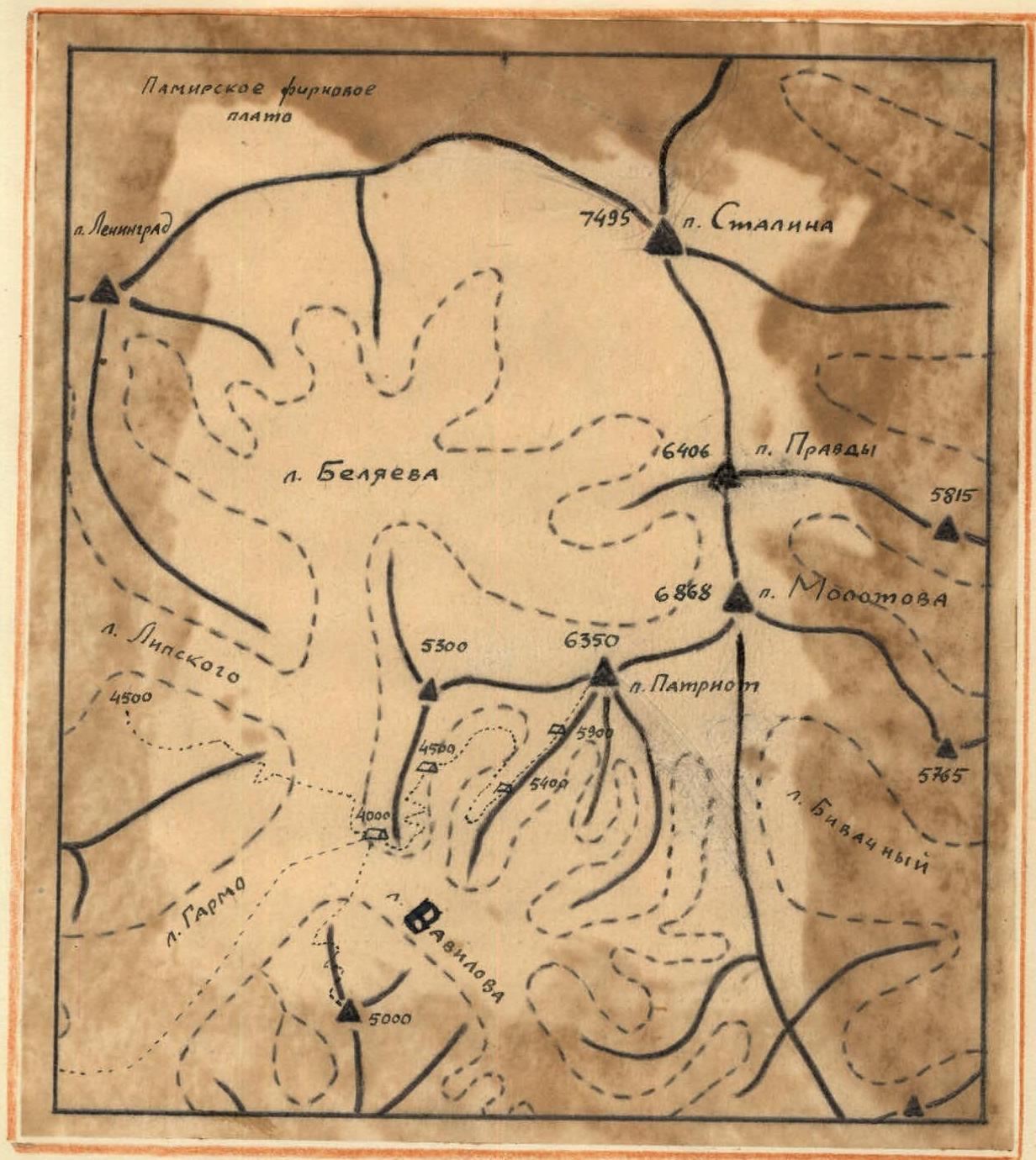 Fig. 1
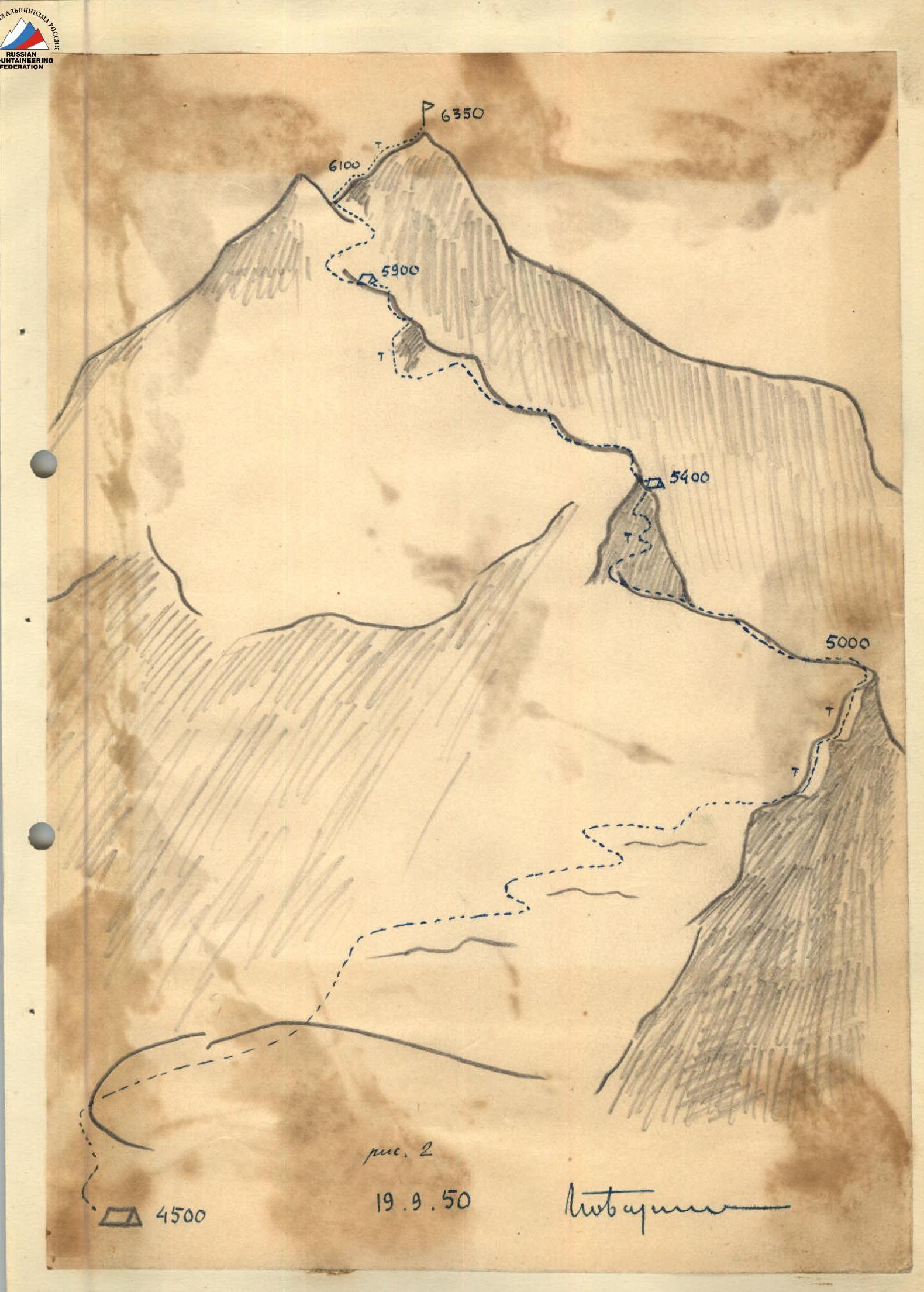 Fig. 2
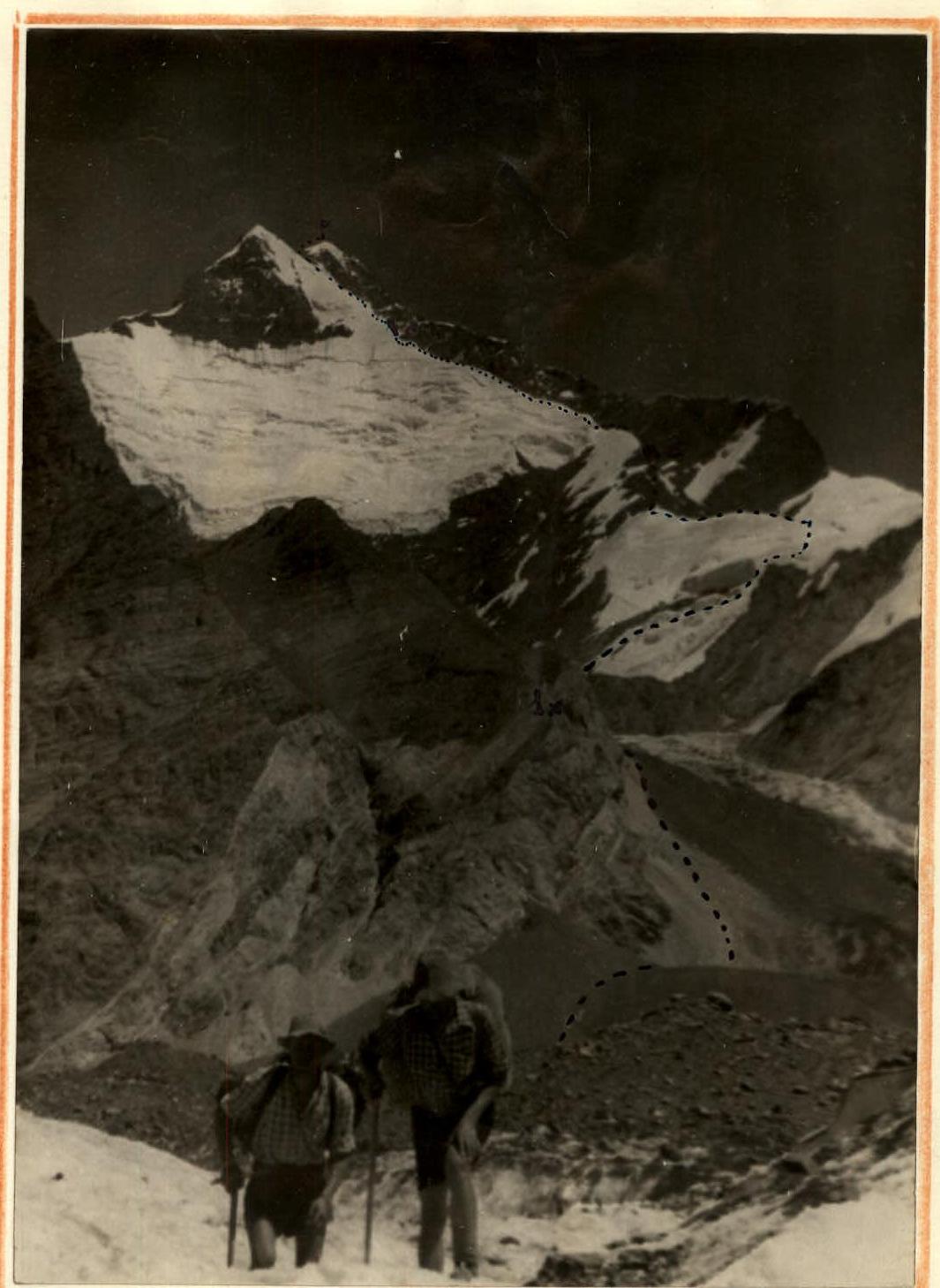 Fig. 3. Taken from Garmo Glacier
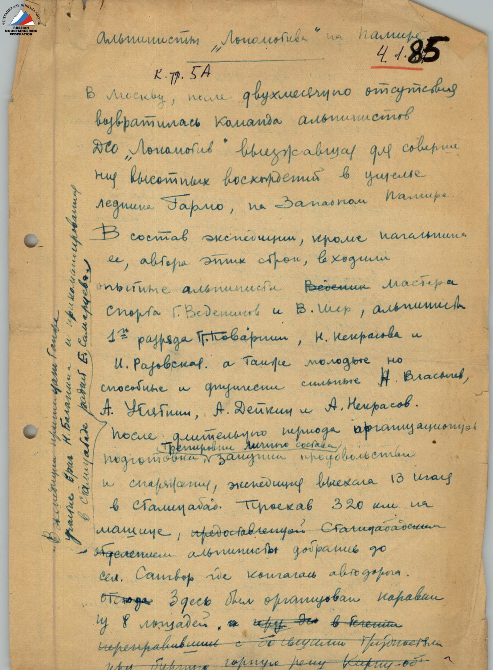
Lokomotiv Alpine Club Members in the Pamirs
Category III, 5A April 4, 1985
The Lokomotiv Sports Society team of mountaineers returned to Moscow after a two-month absence, having undertaken high-altitude ascents in the Garmo Glacier valley on the Western Pamirs. The expedition included, apart from its leader, the author of these lines, experienced mountaineers: Master of Sports G. Vedenikov, V. Sher — 1st category mountaineer, G. Povarnin, N. Nekrasova, and I. Razovskaya. As well as young but capable and physically strong N. Vlasiyev, A. Ubiennykh, A. Deikin, and A. Nekrasov.
After a prolonged period of organizational preparation, training of personnel, procurement of food and equipment, the expedition departed on March 13 to Stalinabad. Having traveled 320 km by car provided by the Stalinabad mountaineering section, they reached the settlement of Satvor, where the motor road ended. From here, a caravan of 8 horses was organized, and after 6 days, having crossed with great difficulty the turbulent mountain river Kirgiz-ob.
The expedition continued on foot. For three days, the expedition advanced through narrow valleys, fording turbulent mountain rivers, making their way waist-deep through thickets of juniper and birch in the picturesque but hard-to-reach Garmo valley. The entire expedition cargo (over 1000 kg) was carried on the mountaineers' shoulders. At the head of the main tributary of the Garmo Glacier, a base camp was set up on the glacier at an elevation of 3200 m above sea level. The radio station, in the skilled hands of Samartsev, ensured daily communication with Stalinabad and, via telegraph, with Moscow. After a day of rest, the entire expedition, except for the doctor and radio operator, set out on a reconnaissance to the upper reaches of the glacier. The difficult path with burnt sections along the 20-kilometer glacier. Over two days, the mountaineers made the difficult journey with burnt sections.
Along the heavily crevassed glacier. Along the way, numerous tracks of bears, leopards, and wild goats were encountered. Once, there was even a particularly pleasant face-to-face encounter with a haughty leopard. At the confluence of the Garmo and Vavilov Glaciers, on a green plateau above the glacier, at an elevation of 4000 m, the 2nd camp was set up. Over 10 days, a detailed reconnaissance of the Garmo, Vavilov, and Lipsky Glaciers was conducted. A. Vlasiyev, A. Deikin, A. Blyum, and A. Nekrasov made an ascent to Shcherbakov Peak, with an elevation of over 5000 m. A complex unnamed peak over 6000 m, towering above the camp, was identified as the main object for the first ascent. On August 13, preliminary reconnaissance allowed the team to outline the path. On August 13, B. Garf, V. Sher, P. Povarnin, and G. Vedenikov conducted a preliminary product delivery to an elevation of 5200 m. On August 17, the assault team consisting of B. Garf, P. Povarnin, G. Vedenikov, and N. Vlasichev, accompanied by the auxiliary group A. Deikin and A. Ubiennykh, set off.
The camp at an elevation of 4000 m was set up in the upper cirque of the glacier, at the foot of the southeastern foothill of the peak. The next day, the mountaineers ascended steep ice slopes to the ridge and laid a path along it. The steep and sharp ridge required careful protection during the ascent. After retrieving previously left supplies, which had become quite noticeable, the pace of advancement slowed. Having overcome a 300-meter section of coarse-grained, brittle, and steep rocks, they stopped for the night on a narrow icy platform at an elevation of 5400 m. To avoid falling into the abyss at night, they had to tie themselves to pitons driven into the ice. The next day, only the assault team ascended further. Deikin and Plyatkin were sent down. The higher they went, the more difficult the path became. The lack of oxygen was felt. Altitude sickness manifested in Vlasichev with symptoms such as nausea and headache. The last camp was set up at an elevation of 5900 m.
The next morning, before dawn, leaving provisions in the tent, the assault team set off. Severe frost. Vedenikov, feeling unwell, remained in the tent. Despite warm clothing and footwear, the -20°C frost penetrated to the bones. After 30 minutes, the mountaineers were forced to rub their whitened toes. At an elevation of 6100 m, Vlasichev's condition worsened significantly, and he had to be left on the rocks, where he, warming up in the sun, waited for the return of the climbers. The last hundreds of meters proved to be the most challenging. The slightest wrong step threatened a fall into the abyss. Every 20 steps, a wildly beating heart forced them to stop for rest. But finally, the ridge turned into a gentle dome. There was nowhere higher to go. On August 23, at 12:20, Lokomotiv mountaineers B. Garf and P. Povarnin stood at the highest point of the peak, which they named "Patriot Peak".
The altimeter showed a height of 6350 m. This ascent, by its complexity, is approximately classified as the highest (V) difficulty category and represents a new achievement in Soviet mountaineering. The expedition, organized entirely by the efforts and resources of the Lokomotiv Sports Society, fulfilled the task set before it. Until this year, Lokomotiv mountaineers had successfully participated in long traverses (crossings) and technically complex, "wall" ascents. For the first time this season, they successfully completed a series of record ascents to highly complex peaks. This year, for the first time, they successfully tried their hand at the most challenging type of mountaineering — high-altitude ascents.
Master of Sports USSR B. Garf.