Ascent Log
- Region of ascent — Kamchatka, Ganal Range.
- Peak — V. Yuzhnaya 2050 m, Southern Ridge.
- Class of ascent — combined.
- Estimated category of difficulty — 2B.
- Height difference — 550 m.
- Route length — 1425 m.
- Number of days — 1 day.
- Number of walking hours — 8 h.
- Leader, participants, surname and initials, sports rank.
1). Bichenko Alexander Nikolaevich, CMS. 2). Sagitova R. — 2nd sports rank. 3). Konshin A. — 3rd sports rank. 10. Departure to the route June 14, 1998. 11. Return to base camp June 14, 1998.
The ascent was organized by year-round training camps, KUTH tourist club. Report compiled on October 3, 2007.
General Photo of the Summit
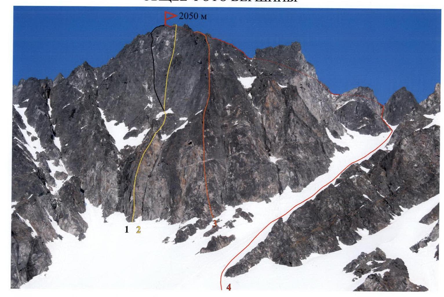
- "Through the center of the northwest wall". 5B category of difficulty. F. Farberov, S. Panyukhin. 1991.
- "M-33" 5B category of difficulty. I. Benedyk, O. Chirik, A. Bichenko. 2001.
- "Along the edge of the northwest wall". 5A category of difficulty. A. Bichenko, A. Alekseev, I. Bekrin. 1995.
- "Along the Southern ridge". A. Bichenko, A. Konshin, R. Sagitova. 1998.
Shooting point № 1 June 12, 2006. Height 1050 m. Camera: Canon Power Shot Pro 1 (Zoom)
Route Description by Sections
The approach to the start of the route is described on page 3.
Section R0
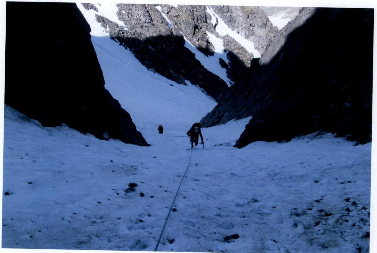
Up a snowy couloir straight up about 500 m, towards the saddle. Steepness 25–35°.*
Section R1
80 meters before the saddle, turn left into a narrow steep couloir (snow-ice section — 40–45°, 50 m, 2–3 category of difficulty. Photo №2), which ends with a vertical, slightly inclined internal corner, leading to a rocky ridge (photo №1). Station (rocky outcrop, 1 vertical and 1 channel hook) — at the left wall, 10 m from the start of the chimney.
Section R2
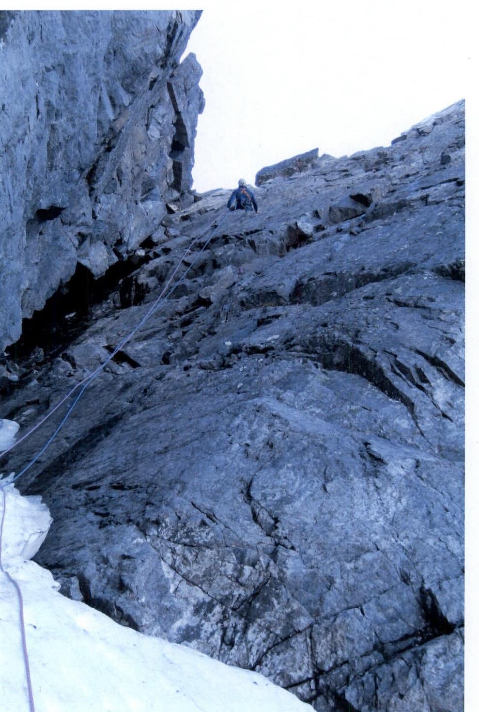
From the station — up to the base of a 35-meter internal corner, which starts with a vertical 10 m chimney. Up the chimney (stemming 4 category of difficulty, photo №3). Above the chimney, the corner is clogged with small "loose rocks" and large, unreliable stones; here it is more correct to move to the right wall and then up the smooth monolithic rocks (photo №4), sometimes stemming to the opposite wall is possible, but be careful with the choice of holds, as this side is heavily destroyed. Section along the wall 20 m, 4+ category of difficulty. At the end of the section — a narrow oblique ledge. Above the ledge, on the wall, a rappel station is left, also convenient for safe organization of belays. Along the ledge, up and left 5 m — exit to the ridge. Station on large boulders (photo №5). On this section, friends №0–№4** were used, 1 vertical and 2 channel hooks.
Section R3
Further — left along the ridge, composed of large boulders, towards the summit. After 100 m, cross the saddle and move, on the right side, another 170 m, bypassing the slope of the peak "Devyataya bashnya" (Ninth tower), gradually gaining height, reach the descent into a steep couloir.
Section R4
Station — a large boulder. Descent — rappel 30 m along a heavily destroyed slope into the couloir. Up the couloir 50 m to the saddle and another 20 m — exit along inclined slabs to the ridge. The entire section — climbing of 2nd category.
Section R5
The final section — to the summit about 200 m. Along a simple ridge, reach a horizontal terrace***, leading to the "Razor's edge" pass. Movement across the pass with simultaneous belay and along inclined slabs along the ridge — exit to the summit. The summit is an inclined, up to 35°, monolithic slab with dimensions of 4 × 5 meters. A hook is driven into the peak part, and a can with a control note is attached.
Descent from the summit via the ascent route.
- By September, the snow in the couloir almost completely melts, exposing rock scree and ice sections. In the upper part, small scree covers inclined, up to 40°, rock slabs, making movement difficult.
** The team used friends of the following size range:
- №0 — 12–15 mm
- №1 — 14–18 mm
- №2 — 18–23 mm
- №3 — 20–25 mm
- №4 — 24–30 mm
- №5 — 28–35 mm *** In case of a forced overnight stay — the moss-covered horizontal terrace can serve as a convenient place for the group to stay.
Brief Overview of the Ascent Region
In the southern part of the Kamchatka Peninsula, within the system of the Big Eastern Ridge, there is a unique, compact region — the Ganal Range. Its length from northwest to southeast is 20 km, width is about 10 km. Maximum height — peak Glavnaya 2062 m. The region is characterized by alpine mountain structure, with wall height differences reaching 450 m. Despite the relatively low absolute height of the objects, winter here lasts nine months. The first frosts occur in early September, and snow falls around September 15–20. In December–February, temperatures reach −45°C. Snow at the base camp level melts only by mid-June. Major ascents in the region are made during the summer. The most suitable period for expeditions is starting from mid-June. At this time, it is already warm enough, and there are no mosquitoes and midges that are very bothersome in July. However, the most stable and clear weather is in late August and early September. From the city of Petropavlovsk-Kamchatsky, it is convenient to reach the bridge over the Vaktan Malkinsky River — 144th km of the Milkovo highway (see the map-scheme of the area) by any vehicle. Beyond the bridge — turn right, along the forest road, you can drive a total of 5–6 km. Further on foot or by high-clearance vehicle, another 5 km to the entrance to the gorge on the left. This is the first, in the direction of travel, tributary of the V. Malkinsky River. Here the road ends. Further left, in the bushes of alders, a footpath begins. Walk along the left side of the valley, up to the exit to the terrace. Then cross the bed of a small stream at the border of the forest and shrubs. The ascent to the upper valley will take 50–60 minutes. From this place, a panorama of all the main peaks opens: Glavnaya, Palets, Ptitsa, Yuzhnaya (shooting point №1). From here to the base camp is three kilometers. Then move along the left slope of the tributary flowing from Yurcik mountain; after 300 m, cross the tributary and go in the direction of the cirque, to the stone pine trees on the moraine cushions. Here, near the right side of the gorge, under a clearly defined pass, is a good place for a base camp. Travel time from the city to the Vaktan Malkinsky River — 2 h 30 min. Walking part of the journey — 10 km — 3 h 30 min–4 h. In the cirque of Ganal Range, helicopter landing is possible. Flight time — 30 min. Approach to the route: from the base camp, up the gorge, along the stony moraine — 1 km to a large snowfield that completely covers the bottom of the cirque. Then move along the snowfield straight, then up the steep snow towards the couloir descending from the peaks Yuzhnaya. Here is the beginning of the ice-snow part of the route. Time to approach the route — 1 h.
Map-Scheme of the Ascent Region
Scale: 1:125 000
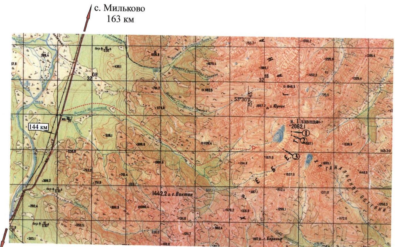
Petropavlovsk-Kamchatsky 134 km.
- peak Palets. 2007 m.
- peak Ptitsa. 2006 m.
- peak Yuzhnaya. 2050 m.
Path of approach. ► — Base camp. 900 m. □ — Shooting point № 1. 1050 m.
Technical Photo of the Route

R — belay station (№ p/p)
The arrow indicates the direction of photo shooting:
Shooting point № 1 Date: June 12, 2006 Height: 1050 m Camera: Canon Power Shot Pro 1 (Zoom)
Technical Description of the Route
The route begins with an ascent along a wide snowy couloir, 1000 m long.
First section:
- 750 m
- steepness 25–35°
- simultaneous ascent
Second part:
- 150 m
- the couloir becomes narrower
- steepness increases to 40–45°
- traversed with alternating belay
Ascent along the rocky massif:
- belay stations are organized behind rocky outcrops and with hook belay
Approach to the rocky chimney-like internal corner:
- length — 25 m
- steepness — 75–80°
- key section of the route
- traversed by free climbing, using intermediate hook belay
- climbing of 4th category of difficulty
- rocks are solid
- belay is organized through placements and hooks
Exit to the ridge:
- length — 450 m
- simultaneous movement in teams
- ridge is traversed along the way, on the right side
Last 50 m:
- exit to the summit along a rocky sharp ridge
- steepness — 50°
- climbing is simple
- belay through outcrops
The summit is a small rocky area.
Descent:
- along the ascent route
- down the internal corner — rappel
- a stationary station is left
The ascent takes 8 hours.
Table of Main Route Sections
| Date | Designation of sections | Steepness of slope | Length | Difficulty | State of the route |
|---|---|---|---|---|---|
| June 14, 1998 | R0–R1 | 25–35° | 750 m | 1 | Snow-firn. |
| R1–R2 | 40–45° | 150 m | 2 | Snow-firn. | |
| R1–R3 | 75–80° | 25 m | 4 | Internal rocky corner | |
| R3–R4 | 45–50° | 450 m | 2 | Rocky ridge. |
PHOTO №3
Section R2. Chimney. The photo was taken from the station of section R2. Camera: Canon Power Shot Pro 1 (Zoom), July 12, 2007.
PHOTO №4
Section R2. The photo was taken from the station of section R2. Camera: Canon Power Shot Pro 1 (Zoom), July 12, 2007.
PHOTO №2
Section R1. The photo was taken from the station of section R2. Camera: Canon Power Shot Pro 1 (Zoom), July 12, 2007.
PHOTO №1: Internal Corner
Key Section of the Route
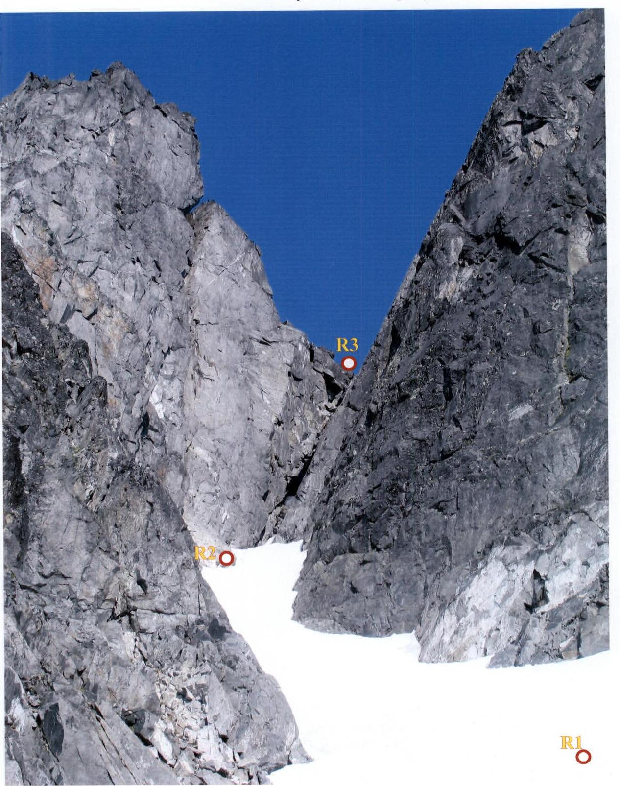
R2 — belay station, rappel loop (1740 m). R3 — belay station, rappel loop (1780 m). The photo was taken on July 12, 2007 (1670 m). Camera: Canon Power Shot Pro 1 (Zoom).