Ascent Passport
I. Climbing category: technical 2. Climbing area: Caucasus; 2.8; Kolka glacier 3. Peak, route: Dzhimaraikhokh peak (4773 m); I knee-fold of the North ridge from Kolka glacier 4. Estimated category of difficulty — 3B category of difficulty; first ascent 5. Route characteristics: height difference — 2000 m, route length — 2800 m, length of sections: 5 category of difficulty — 20 m, 4 category of difficulty — 200 m, average steepness of the main part of the route — 40°–45° 6. Pitons hammered: ice screws — 50 pcs., rock pitons — 3 pcs., chocks — none 7. Number of climbing hours/days — 20/2 8. Number of overnight stays: 1 on approach, 1 on the route, 1 on descent 9. Leader: Levkovsky Yuri Vasilyevich — 1st sports category. team members: 1. Gudenko Evgeny Vladimirovich — 3rd sports category. 2. Kabisov Artur Ruslanovich — 3rd sports category. 3. Lunev Alexander Vladimirovich — 3rd sports category. 4. Surkov Dmitry Anatolyevich — 3rd sports category. 10. Coach: Proskuryakov Ruslan Pavlovich — Master of Sports. 11. Departure to the route — August 27, 1995. Return to the bivouac — August 30, 1995. 12. Organization: KM FA RSO
Preparation for the Ascent
During preparation for the ascent, the following was done:
- reconnaissance of approaches to the peak,
- determination of the route orientation,
- preliminary assessment,
- photographs of the route and area were taken,
- principles of radio communication were determined.
During preparation, it was determined that the best communication would be established with Vladikavkaz — the route: direct visibility, which ensures stable radio communication at the bivouac and throughout the route.
Approach Description
From Vladikavkaz to "Karmadon" sanatorium — by regular bus — 1 hour. Further — movement along the road through the village Tmenikau via Kosh above the Genaldon River. After 2 hours, the road descends to the river itself and disappears among the stones. Along the trail among the stones on the left side (orographic) of the river, ascend to the hot mineral springs. From "Karmadon" sanatorium — 3.5–4 hours.
From the springs:
- descend traverse to the river,
- cross it near the beginning of the large moraine descending from the central part of the Mayli glacier tongue,
- further ascend along the moraine,
- reach the Mayli glacier in its middle part,
- gradually move to the right onto the moraine deposits,
- approach the beginning of the long green ridge,
- initially ascend along it,
- then, descending to the right to the stream along the trail, exit to the hut on the Shelistenko clearing — 3–4 hours.
From the hut:
- movement along the ridge of the right-bank moraine of the Kolka glacier,
- then, descending traverse,
- along the moraines under the large avalanche deposit lying under the Kolka glacier icefall — 2 hours.
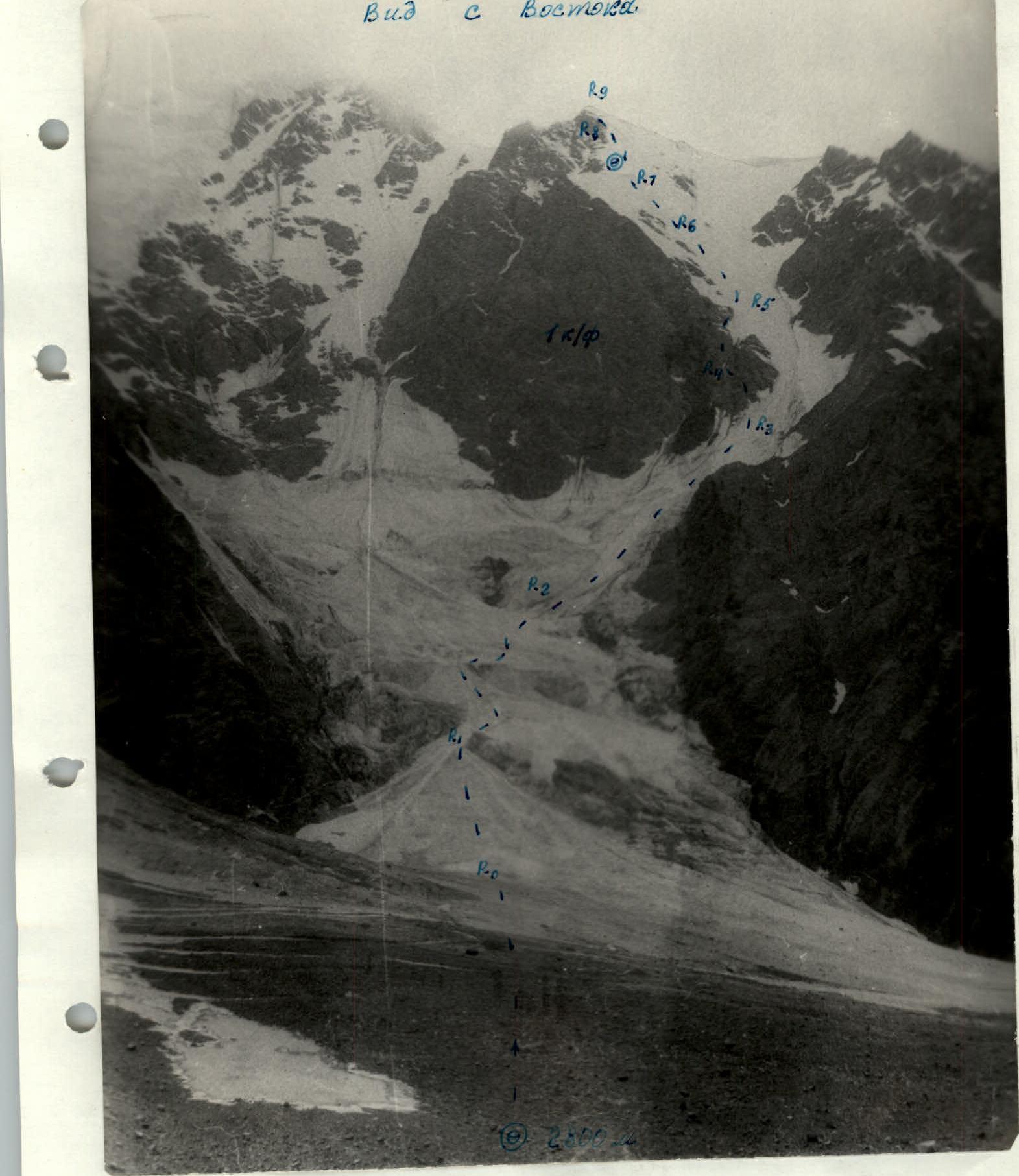
Here is the initial bivouac. Elevation — 2800 m.
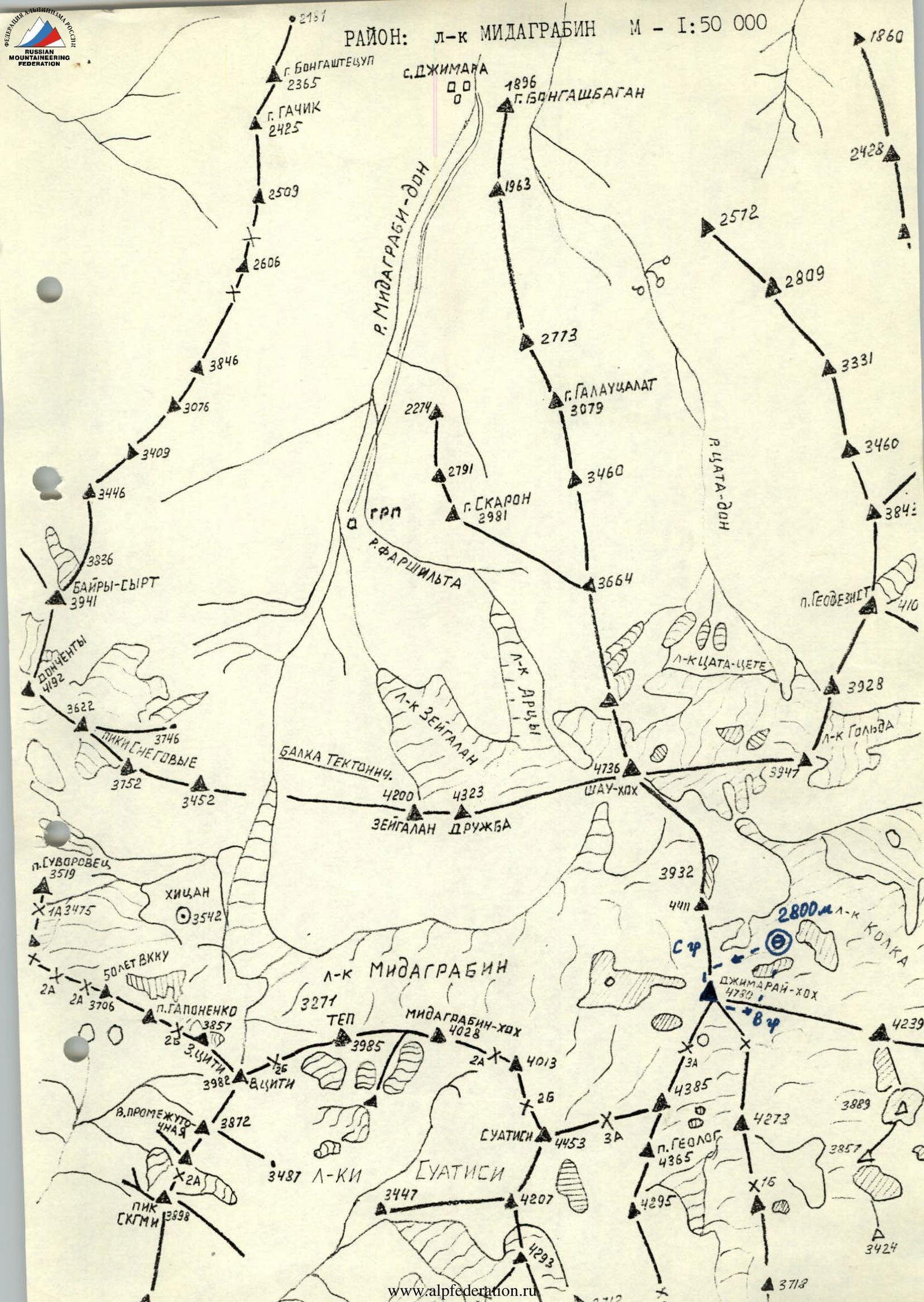
Brief Overview of the Climbing Area
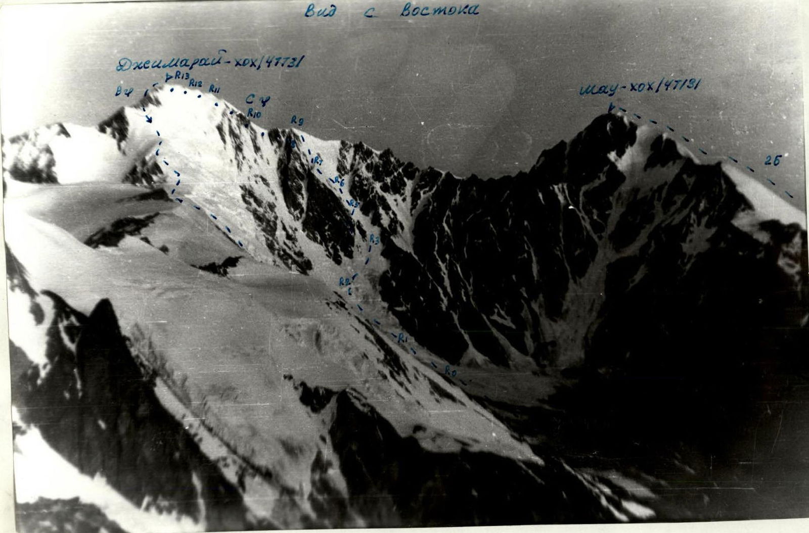
The climbing area is located in the eastern part of the Central Caucasus. The highest peak in the area — Dzhimaraikhokh (4773 m) is a key peak of the Front Range, connected:
- by a ridge to Maylikhokh,
- by a ridge to Shau-khokh,
- by the southern ridge to Suatisi-khokh.
To the west, the steep ice-rock Western rib falls onto the Midagrabin glacier, along which a route of 4A category of difficulty is laid. To the south, a route of 3A category of difficulty goes to the Suatisi glacier. From the northern ridge to the east, several unclimbed rock-ice counterforts descend to the Kolka glacier. The route was ascended via the I knee-fold of the North ridge.
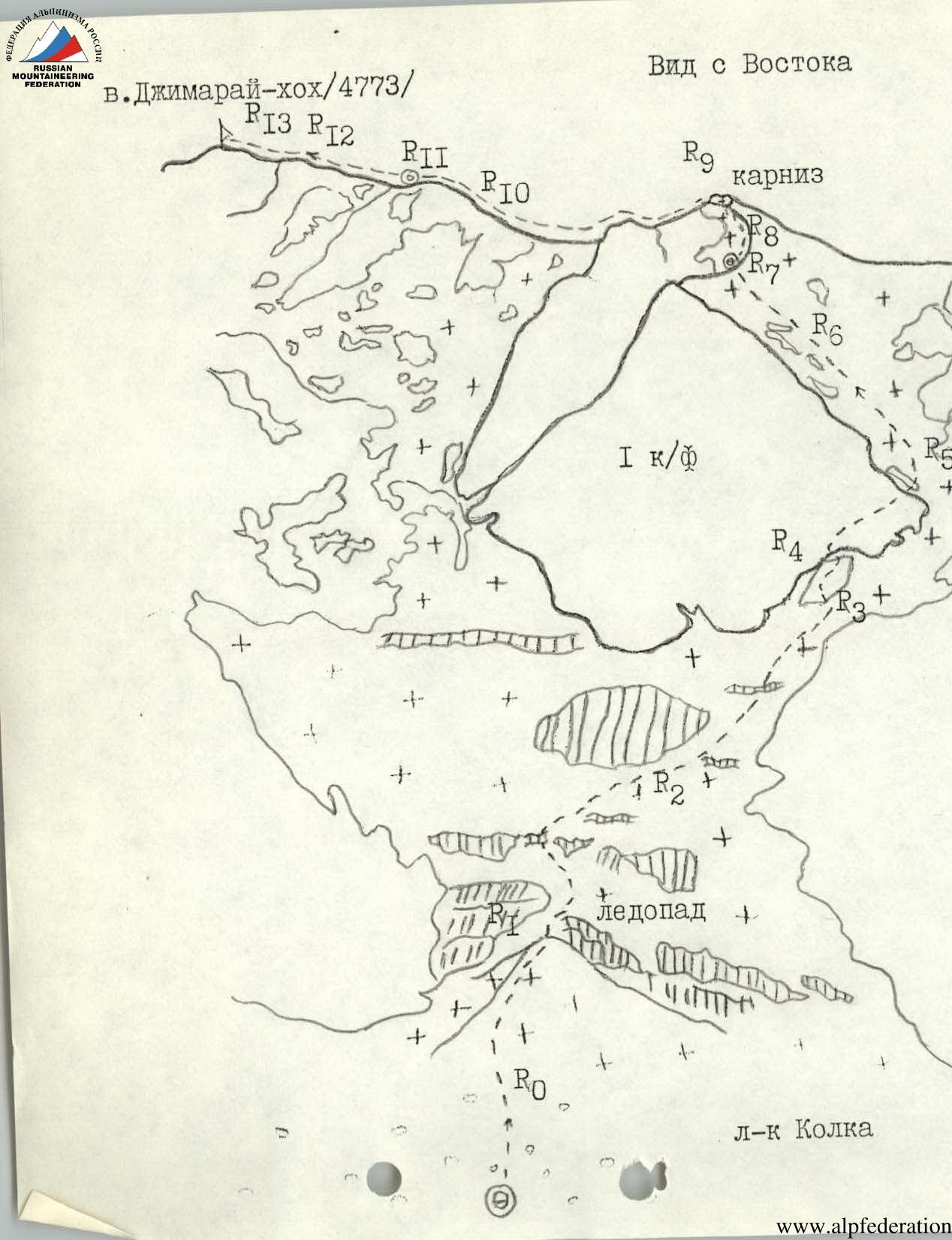
Route Description
Day 1:
From the bivouac on the moraine, move towards the avalanche deposit — 30 minutes. Along it 150–200 m; 30°–40° under the Kolka glacier icefall. The icefall flows from under the NE wall of Dzhimaraikhokh peak, cut by crevasses, and from the NE wall and I knee-fold, ice and rockfall are possible. It's advisable to pass through early in the morning. Further — straight up in rocks 40 m; 40° (firn, ice), cross the bergschrund via a snow bridge, turn right-up. After crossing 2–3 crevasses, exit under the ice ledges (on the left). Under them, turn right and ascend along a steep snow-ice slope 300–400 m; 40°–45°, 2–3 category of difficulty, cut by crevasses, deep gullies, where rockfall is possible. From the I knee-fold — piton belay. Further — ascent to a large rock island. From the bivouac — 4–5 hours. The rock island, like the I knee-fold, is composed of loose rocks (shales). Ascent along it straight up 120–150 m; 45°; 2 category of difficulty, belaying is difficult until its end. Move left onto the rocks of the I knee-fold and along them right-up 100–120 m; 50°; 3 category of difficulty, exit onto the ice slope on the right side of the I knee-fold triangle. Ascent straight up along the ice slope 200 m; 40°; 3 category of difficulty, piton belay. Higher, the steepness increases to 45°; 120 m; 4 category of difficulty, at the end, exiting onto the snow-ice shoulder of the I knee-fold — 10 m up to 50°. On the shoulder — bivouac (carve a platform in the ice). From the island — 6–8 hours.
Day 2:
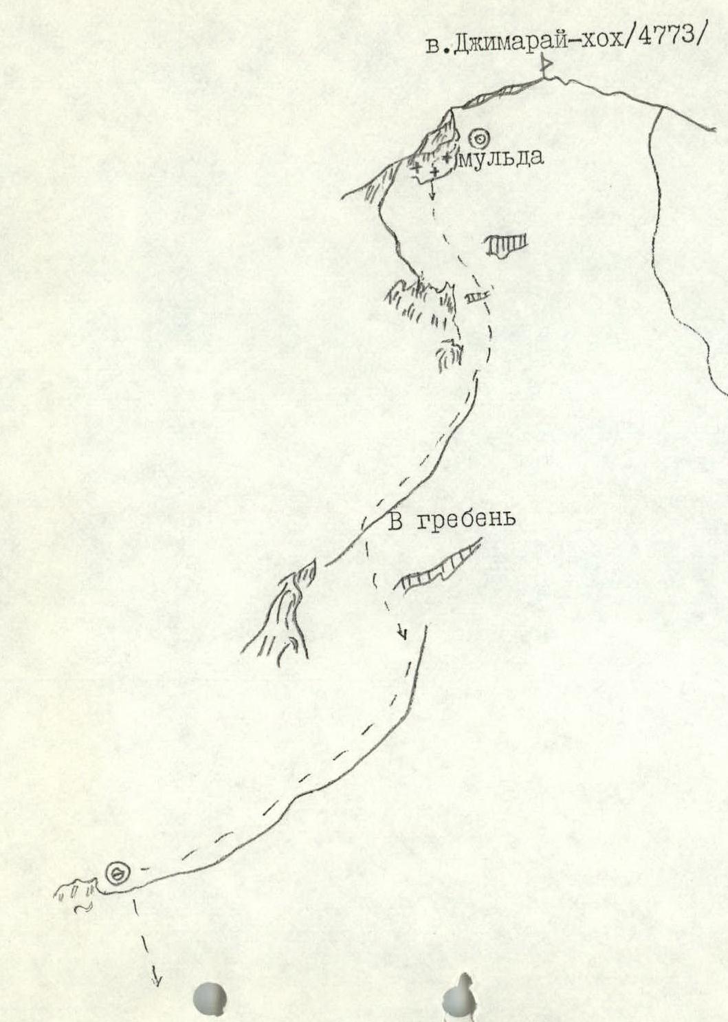
Move straight up along the ice slope on the left side of the I knee-fold ridge — 260 m; 45°; 3–4 category of difficulty, under a cornice on the ridge, which is straight ahead — 4–5 m; 70°–80°; 5 category of difficulty, piton belay. Further, left, ascent along the ridge (snow, firn) (beware of large cornices on the left). In 1.5–2 hours, exit onto the rocks of the ridge — 60 m; 45°–50°; 2–3 category of difficulty. Along the rocks, ascent onto the ridge shoulder, where a bivouac is possible. From the shoulder, descend 20 m; 35°, and behind it, ascend along the ice wall 15 m; 50°; 5 category of difficulty. Further along a gentle snow ridge, at the end, along snow-covered rocks 2 category of difficulty, ascend to Dzhimaraikhokh peak. From the bivouac on the shoulder — 6–8 hours.
The easiest descent from the peak is along the Eastern ridge to the hut on the Shelistenko clearing.
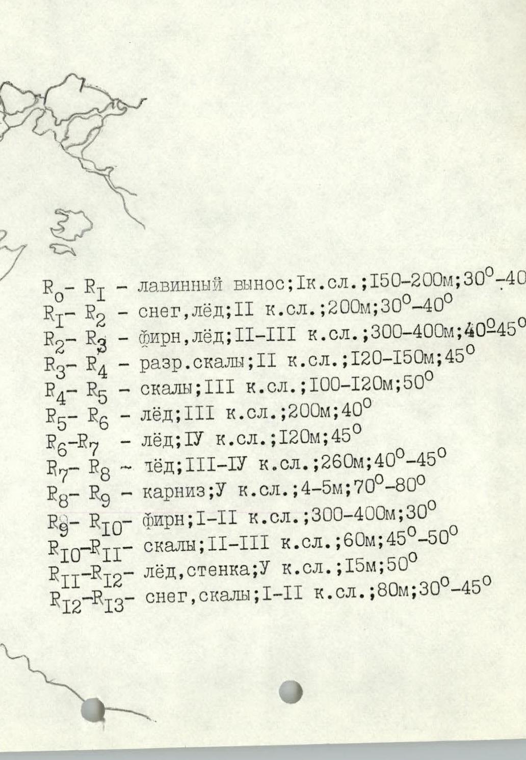
Detailed description of route sections (according to the scheme)
- R0–R1 — avalanche deposit; 1 category of difficulty; 150–200 m; 30°–40°
- R1–R2 — snow, ice; 2 category of difficulty; 200 m; 30°–40°
- R2–R3 — firn, ice; 2–3 category of difficulty; 300–400 m; 40°–45°
- R3–R4 — destroyed rocks; 2 category of difficulty; 120–150 m; 45°
- R4–R5 — rocks; 3 category of difficulty; 100–120 m; 50°
- R5–R6 — ice; 3 category of difficulty; 200 m; 40°
- R6–R7 — ice; 4 category of difficulty; 120 m; 45°
- R7–R8 — ice; 3–4 category of difficulty; 260 m; 40°–45°
- R8–R9 — cornice; 5 category of difficulty; 4–5 m; 70°–80°
- R9–R10 — firn; 1–2 category of difficulty; 300–400 m; 30°
- R10–R11 — rocks; 2–3 category of difficulty; 60 m; 45°–50°
- R11–R12 — ice, wall; 5 category of difficulty; 15 m; 50°
- R12–R13 — snow, rocks; 1–2 category of difficulty; 80 m; 30°–45°
Recommendations
The route is passable in summer conditions; in winter, it is avalanche-prone. In the lower part, there is a danger of rockfall and ice collapse. It's interesting due to the complexity of ascending a high peak; proper tactical planning is crucial.
Recommended for highly qualified groups.
View from the East
1960
View from the East

View from the East
View from the East
Descent Description
The Eastern ridge is ungraded; this group evaluated it as 2B category of difficulty.
From Dzhimaraikhokh peak, continue along the Eastern ridge downwards. The ridge is simple, snowy, with outcrops of destroyed rocks, 1–2 category of difficulty. In 1.5–2 hours, descend into a snowy depression of the Eastern ridge. Good bivouac. Further descent down the ice slope of the Eastern ridge 350–400 m, steepness 30°–40°, until it flattens out, piton belay, beware of ice ledges, in the lower part — crevasses. Along the flattening part, descend 1000 m, then left-down along a steep snowy slope with deep snow 40 m; 50°, and then down along the gentle, very wide Eastern ridge (beware of crevasses) to a large, heavily destroyed rock outcrop on the ridge. Good bivouac. From the peak — 6–8 hours. From here, descend straight down along the ice slope 250–300 m, steepness 40°–30°, until rock outcrops of the rock counterfort appear. Descend via rappel 40 m along steep destroyed rocks onto a gentle snowy slope, along which descend to the lower part of the rock-scree counterfort. From here, descend along screes to the moraine on the right side of the Kolka glacier, along which exit to the hut on the Shelistenko clearing. From the rock outcrop — 6–7 hours.