Ascent Passport
- Ascent class — first ascent.
- Ascent area — Tepli-Arkhon massif.
- Peak — Arkhon Malyy, its height — 3953 m, ascent route — via the Northern wall of the Western ridge.
- Estimated difficulty category — 5B.
- Route characteristics: height difference — 1300 m, length of sections with 5B-6 difficulty category — 370 m, average steepness 76° (of the wall section).
- Pitons hammered:
| rock | ice | bolt | stopper | |
|---|---|---|---|---|
| for belay: | 86 | 3 | 0 | 34 |
| for i.t.o.: | 3 | 1 | 1 | 1 |
- Number of climbing hours — 21.
- Number of bivouacs and their characteristics — two bivouacs (with route processing before the I bivouac). One under the wall (space only for one tent), and the second — on the Western ridge, 200 m from the summit. Both bivouacs are good, rockfall hazard is absent. On the wall itself, only sitting bivouacs can be organized, five ropes from the base of the wall.
- Surname, name, patronymic of the leader, participants and their qualification: Gavrilevsky Oleg Ivanovich — leader — CMS. Trubin Alexander Nikolaevich — CMS. Golovan Sergey Nikolaevich — 1st sports rank. Sukhinina Lyudmila Ivanovna — 1st sports rank.
- Team coach — Akritov Ivan Ponayotovich, Master of Sports.
- Date of departure on the route — August 24, 1985, return — August 26, 1985.
- Organization — North Ossetian Regional Council of the "ZENIT" sports society.
Map-diagram
Tepli-Arkhon massif
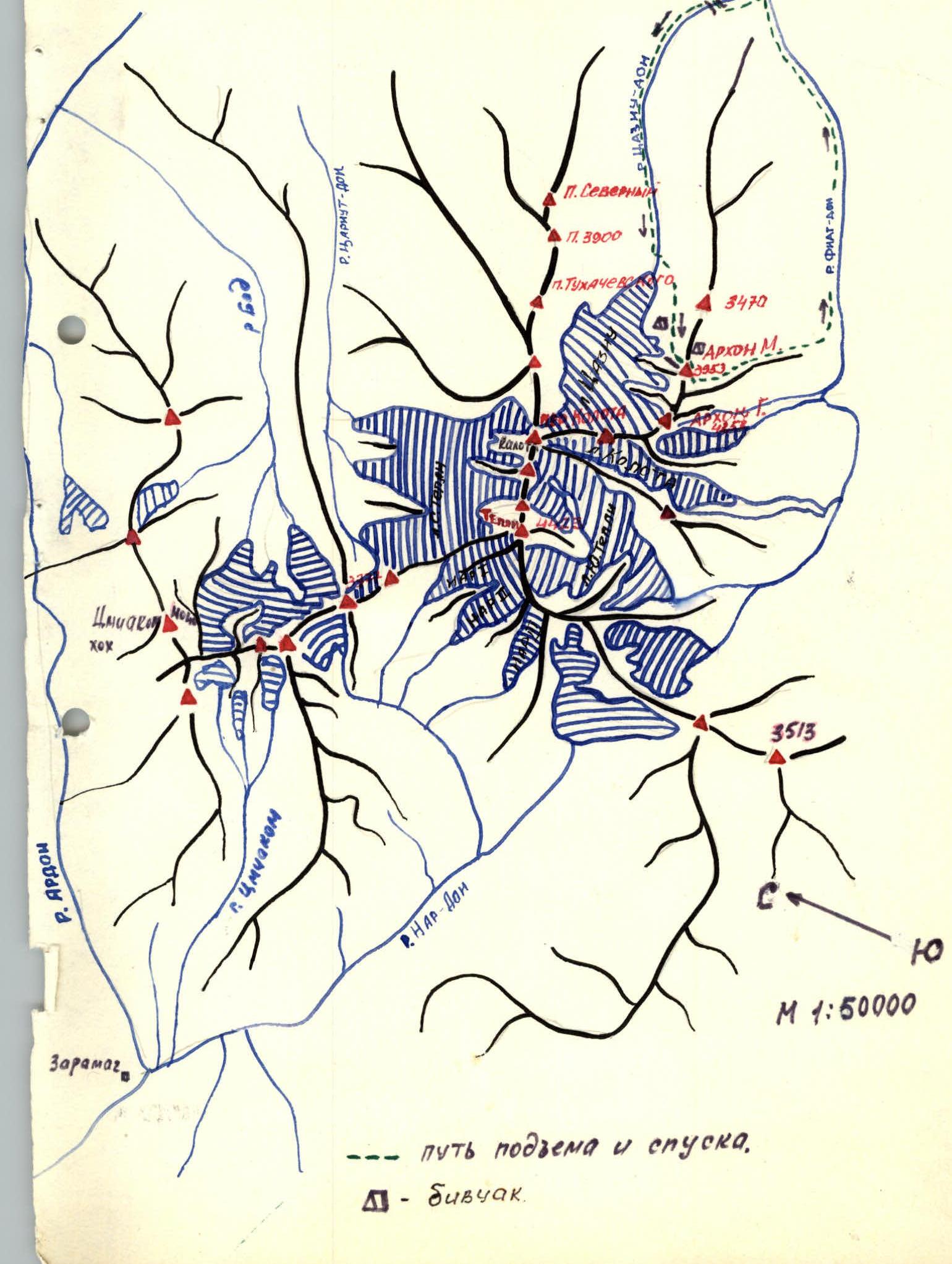
— ascent and descent path. — bivouac.
Brief description of the approach to the route
From Ordzhonikidze, take a scheduled bus to the village of Kharisdzhin in the Fiagdon gorge. Then follow the road (landmark — the Fiagdon riverbed) to pass two bridges, and after the second one, turn right in the direction of travel onto a wide, grassy slope of the Tsaziu gorge. From the final stop to the slope — 40–50 min walk.
Ascent up the grassy slope with a sharp gain in height, then cross the Tsaziu-don river (there is a small bridge) and move along the trail along its left bank (orographic). Having passed the forest zone, exit into the narrow valley of the gorge with three rises. For orientation, there is a small lake on the second rise. Having ascended to the third rise, turn left in the direction of travel and, crossing the river, exit near the glacier onto its right (orographic) moraine. From the turn into the gorge to the exit onto the moraine — 5–6 hours walk.
Crossing the moraine, descend onto a wide talus slope under the massif of Arkhon M. Directly from the moraine, ascend up the talus in its central part to flat, elevated areas above the general relief, where it is convenient and safe to set up a bivouac. From the moraine to the bivouac site — 1 hour walk.
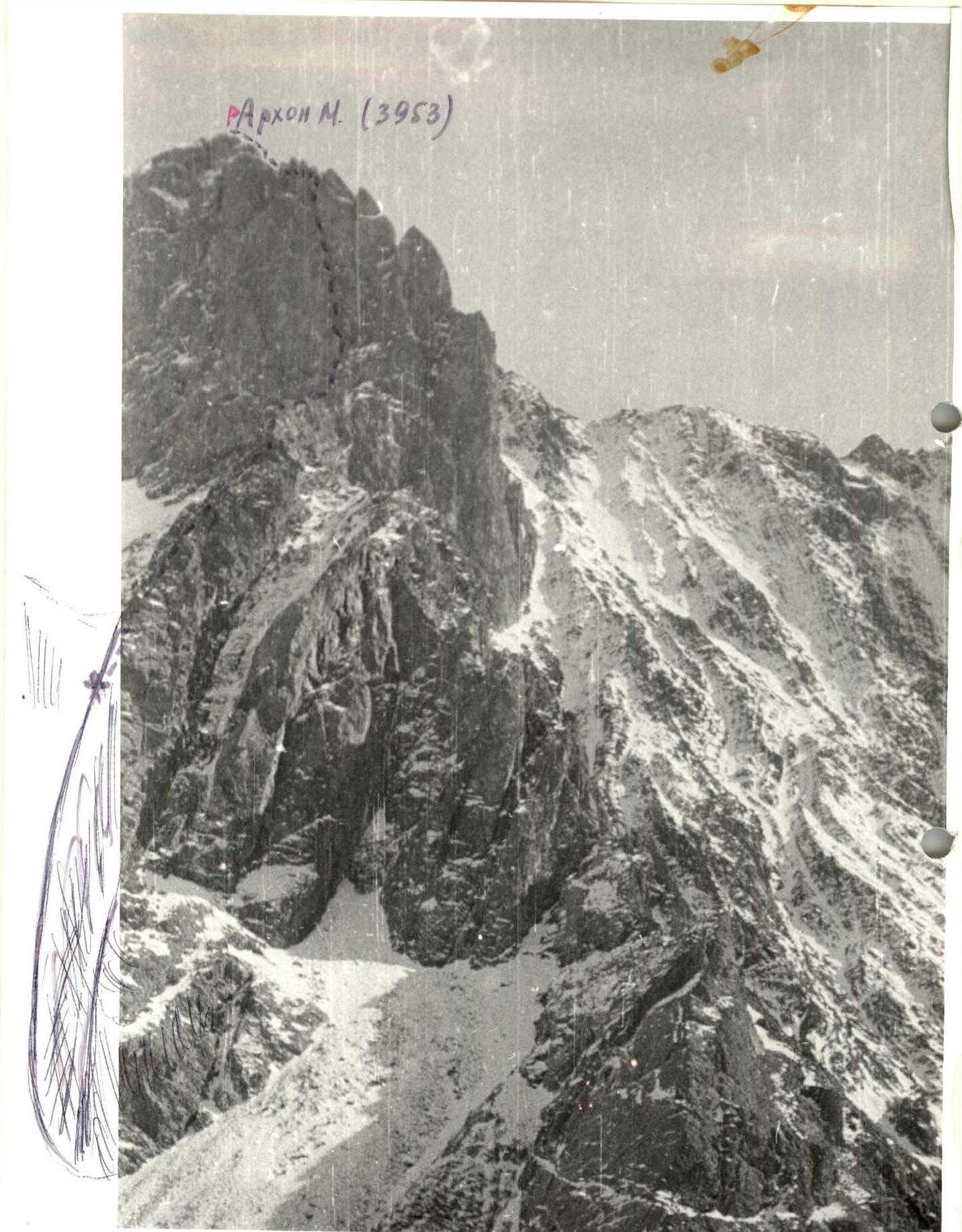
From the sites, in close proximity, the following can be seen:
- lower walls of the massif;
- counterfort;
- summit part of the Northern wall.
To access the route, it is necessary to:
- traverse the talus slope to the right (250–300 m with a slight gain in height) to the walls of the counterfort approaching the Northern wall;
- then, moving up the slope along the walls (there is a small glacier at the top of the slope, down which rocks are falling), find a convenient place to cross to the right onto the counterfort.
Further, along the terrain, with talus shelves and rock outcrops (the path is unambiguous, as the wall stands ahead) — traverse to the right and upwards.
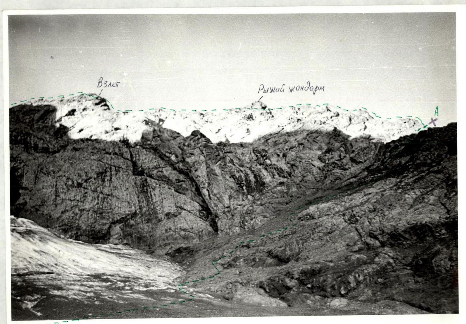
The exit onto the counterfort is shown in the photographs (photo No. 2). From the bivouacs to the exit onto the counterfort — 1–1.2 hours walk.

Arkhon Malyy (3953 m)
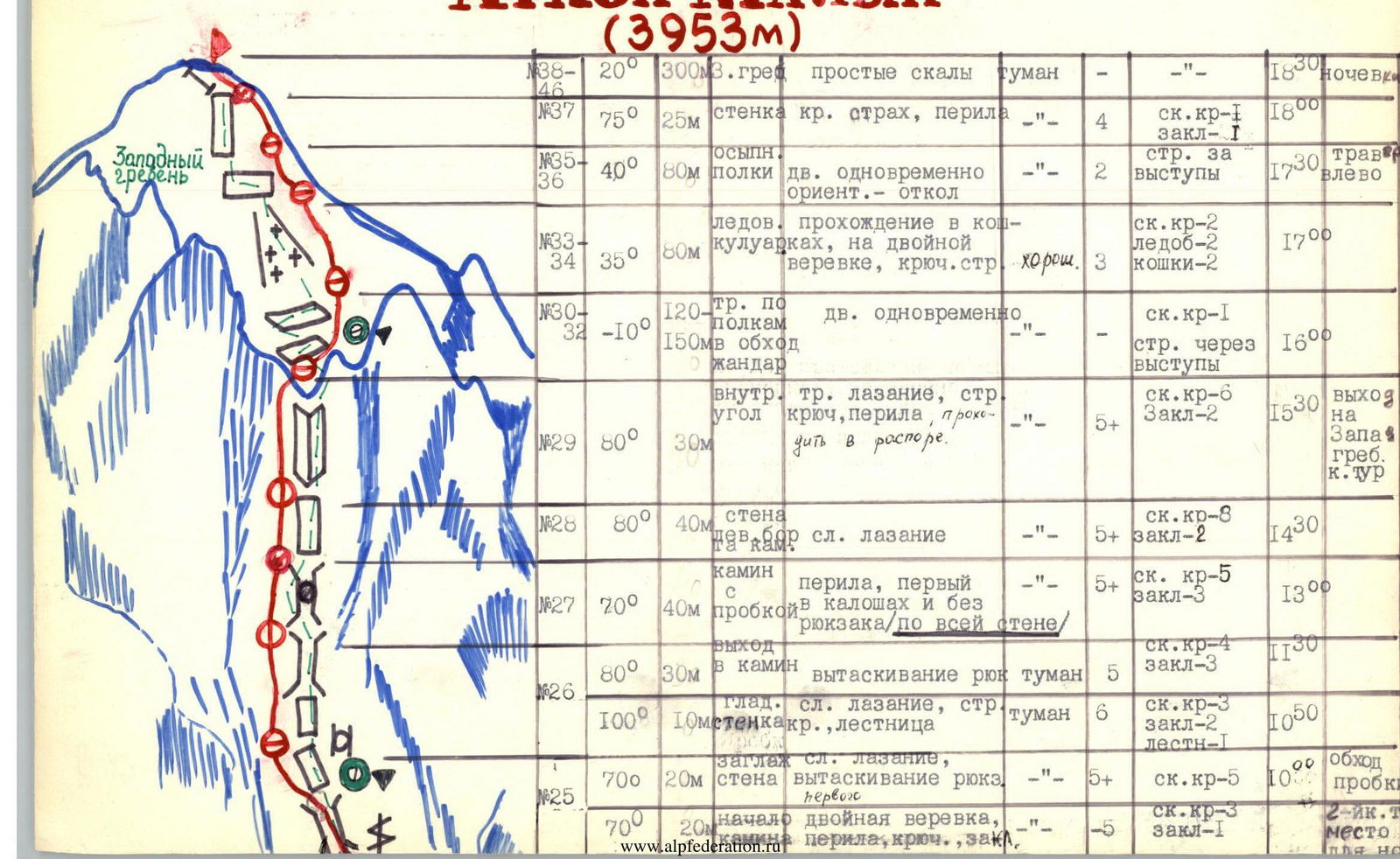
A brief explanation of the diagram. The description of the approach and exit to the route are detailed earlier and shown in photo No. 2. The group started on the route from the bivouacs at 7:00.
The counterfort approaching the Northern wall is composed of coarse-grained granite, with smoothed relief in places. Photo No. 3 shows the general view of the relief (the place of bypassing the red gendarme). The ascent of the counterfort is a forty-meter wall, with overhanging walls on the right and left. This section is passed first in galoshes, on a double rope, and without a backpack. In the lower part of the ascent, there are few cracks, and the upper part transitions into an internal corner with a meter-long overhang (passed using ladders). After the ascent, the counterfort becomes more gentle and transitions into a wall. Here, a platform was laid out for bivouacs, and a control cairn was left. From the platform, part of the wall route (3 ropes) was processed by a pair, after which the group bivouacked at the wall. Photo No. 4 — descent after processing.
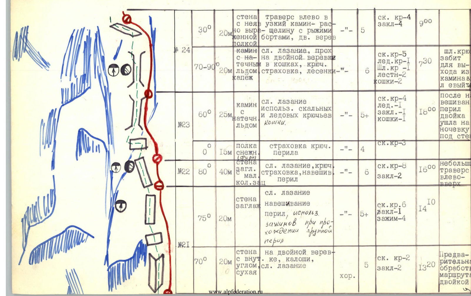
The most technically and psychologically difficult section — the 24th rope of the route. The chosen chimney for passage turns into vertical walls with high, smooth sides, dripping ice, and water flow at the top. Therefore, for traversing along the wall into the left, dry chimney, a bolt hanger was hammered, and ladders were used.
The left chimney:
- is destroyed in the lower part;
- at the top, it turns into monolithic, smoothed rocks with few holds.
In the middle part of the chimney, there is a smooth wall, for the passage of which ladders were used. The passage of one of the sections of the chimney is shown in photo No. 8.
The upper part of the chimney is passed along the right side — walls with few holds and cracks.
The exit onto the Western ridge is made along a wall with a vaguely expressed internal corner, almost vertical.
On the Western ridge:
- a series of gendarmes is bypassed along shelves on the left;
- further movement is along an ice couloir to the left;
- approach to the break in the wall of the summit ridge.
The exit to the summit is straightforward from left to right, 300–350 m. Here, it is possible to set up a bivouac.
Descent from the summit directly along the path to the first saddle between the summits of Arkhon M. and Arkhon Gl. (200 m) and further to the left and down along a narrow couloir (average steepness 40°). In the upper part of the couloir, there is snow and ice. Exit from the couloir onto a wide talus slope and further into the Fiagdon gorge (approximately 2A difficulty category).
The wall section was processed by a pair: Gavrilevsky Oleg Ivanovich and Trubin Alexander Nikolaevich. The first one went without a backpack, in galoshes. The backpack was lifted on a jumar along the main rope. The wall is recommended to be passed by a group in good weather.
Exit onto the counter-slope 9° from
2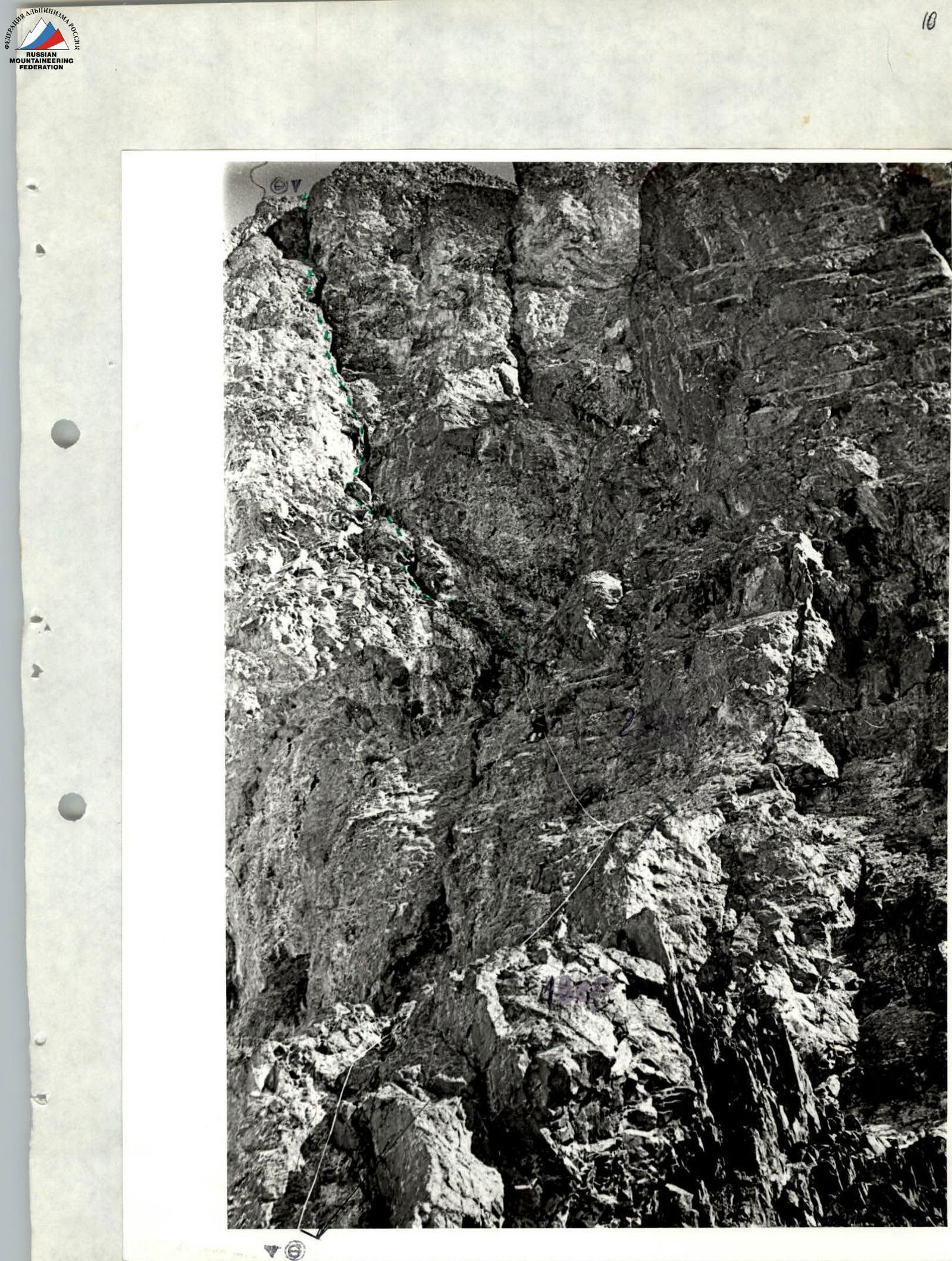 ∇
6
∇
6