Ascent Log
- Ascent classification: technical.
- Ascent area: Caucasus, "Tsey".
- Peak, its height; ascent route: p. ChanchaKhi-khokh, 4450 m, NE wall (first ascent).
- Estimated difficulty category: 5B category.
- Route characteristics: height difference - 1000 m, average steepness - 68°, section length - 5-6 km, technical difficulty - 800 m.
- Pitons used: for belaying, for creating ITO: rock - 153, for creating ITO - 8, ice - 0, bolted - 0.
- Total climbing hours - 46.
- Number of nights and their characteristics: lying down - 2, sitting - 1.
- Surname, name, and patronymic of the leader, participants, and their qualifications:
Goloshchapov Viktor Mikhailovich, Candidate Master of Sports - leader
Goncharov Petr Stepanovich, Master of Sports of the USSR - participant
- Babitskiy Alexander Vladimirovich, Master of Sports of the USSR - participant
- Ovcharenko Valeriy Davidovich, Master of Sports of the USSR - participant
- Artemenko Grigoriy Petrovich, Candidate Master of Sports - participant
- Tarasenko Viktor Vladimirovich, Candidate Master of Sports - participant
- Team coach - Honored Coach of the Ukrainian SSR Matsievitiy Yu.M.
- Date of departure and return: July 18, 1980 - departure from the plateau of the N. cirque of the Tsey glacier, July 21, 1980 - return to the plateau of the N. cirque of the Tsey glacier.

Photo-4, June 13, 1983. Lens Industar-52. Distance - 2.5 km. Shot number - 4. Shooting height - 4600 m.
PHOTOPANORAMA OF THE AREA

- Kizel, 1934, route 4A category.
- Bolizhevskiy, 1964, route 5A category.
- Polevoy, 1964, route 5B category.
- Rusyaev, 1983, route 5B category.
- Grigorenko-Prigoda, route 5B.
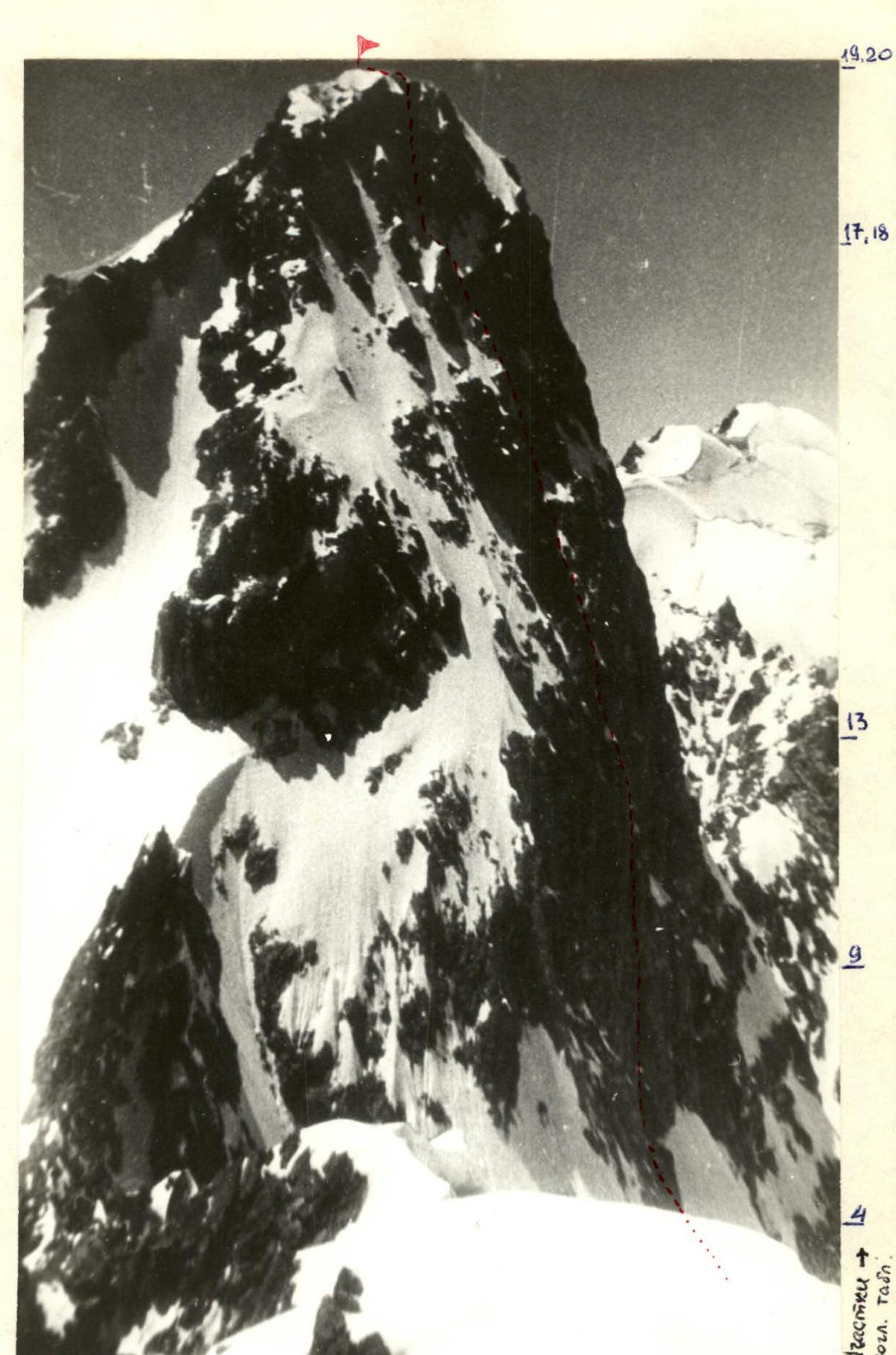
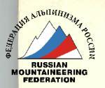
Route profile (taken from p. Mamison). The bastion profile taken with a telephoto lens is shown below (p. 27).
19–20 17–18 15 13
Route profile (taken from p. Bubis-Khokh).
Table
of the main characteristics of the ascent route to ChanchaKhi peak via the left bastion of the NE wall
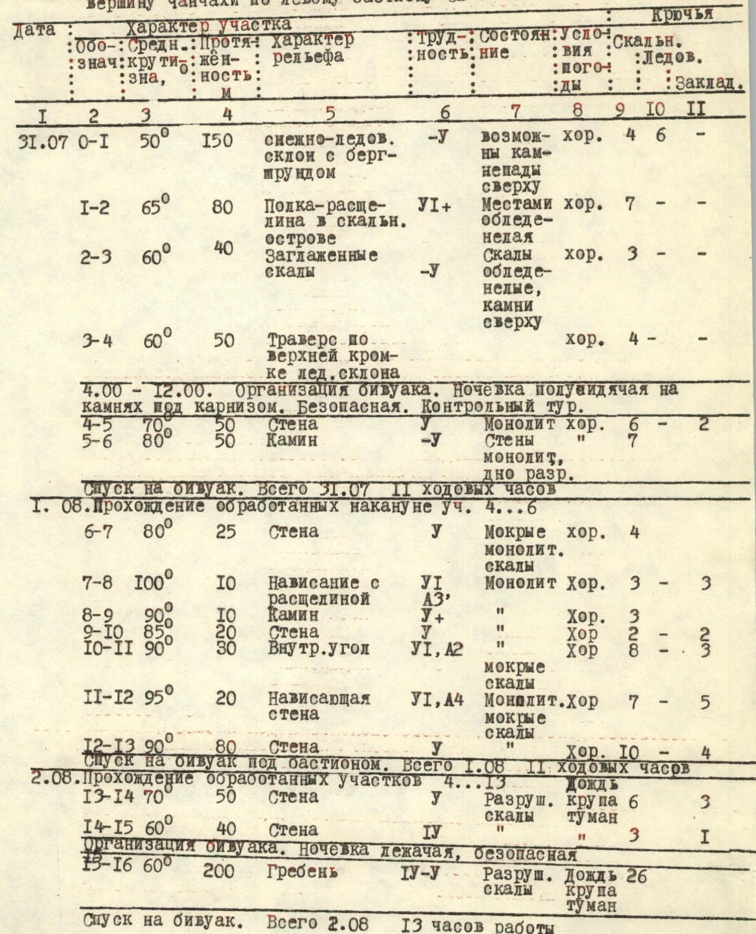
| Date | Notation | Average steepness | Length, m | Terrain characteristics | Difficulty | Condition | Weather conditions | Rock | Ice | Chocks |
|---|---|---|---|---|---|---|---|---|---|---|
| 31.07 | R0–R1 | 50° | 150 | Snow-ice slope with bergschrund | 1 | Possible rockfall from above | good | 4 | 6 | |
| R1–R2 | 65° | 80 | Shelf-crack in a rocky island | 6 | Places with ice formation | good | 7 | |||
| R2–R3 | 60° | 40 | Smooth rocks | 1 | Icy, rocks above | good | 3 | |||
| R3–R4 | 60° | 50 | Traverse along the upper edge of an ice slope | good | 4 | |||||
| 4:00–12:00. Organization of a bivouac. Semi-sitting overnight stay on rocks under a cornice. Safe. Control tour. | ||||||||||
| R4–R5 | 70° | 50 | Wall | Monolith | good | 6 | 2 | |||
| R5–R6 | 80° | 50 | Chimney | 1 | Walls are monolithic, bottom is fragmented | good | 7 | |||
| Descent to bivouac. Total time spent on 31.07: 11 climbing hours. | ||||||||||
| 01.08 | Passage of previously processed sections R4–R6. | |||||||||
| R6–R7 | 80° | 25 | Wall | 1 | Wet monolithic rocks | good | 4 | |||
| R7–R8 | 100° | 10 | Overhang with a crack | 6, A3 | Monolith | good | 3 | 3 | ||
| R8–R9 | 90° | 10 | Chimney | 1 | good | 3 | ||||
| R9–R10 | 85° | 20 | Wall | 1 | good | 2 | 3 | |||
| R10–R11 | 90° | 30 | Inner corner | 6, A2 | Wet rocks | good | 2 | 3 | ||
| R11–R12 | 95° | 20 | Overhanging wall | 6, A4 | Monolith. Wet rocks | good | 7 | 5 | ||
| R12–R13 | 90° | 80 | Wall | 1 | good | 10 | 4 | |||
| Descent to bivouac under the bastion. Total time spent on 01.08: 11 climbing hours. | ||||||||||
| 02.08 | Passage of previously processed sections R4–R13. Rain. | |||||||||
| R13–R14 | 70° | 50 | Wall | 1 | Fragmented rocks | Sleet, fog | 6 | 3 | ||
| R14–R15 | 60° | 40 | Wall | 4 | 3 | 1 | ||||
| Organization of a bivouac. Lying down overnight stay, safe. | ||||||||||
| R15–R16 | 60° | 200 | Ridge | 4–5 | Fragmented rocks | Rain, sleet, fog | 26 | |||
| Descent to bivouac. Total time spent on 02.08: 13 working hours. |
Brief explanation of the table
The start of the route - from the plateau of the N. cirque of the Tsey glacier, opposite the rocky island located 50 m above the bergschrund (R0–R1). It is necessary to start early, as rockfall is possible on this section and section R2–R3. On R3–R4, movement is along the upper edge of a large snow-ice patch. At the end of the section, under the overhanging rocks, is the bivouac site, where the 1st control tour of the route is also located. From the bivouac, return 15-20 meters back and move up and slightly to the right along the wall (R4–R5). After 50 m, a steep chimney begins, the walls of which are monolithic, but the bottom contains many loose rocks (R5–R6). At the end of sections R5 and R6, there are small ledges, but the possibility of overnight stay on them is questionable due to the danger of rockfall from above. Further movement is straight up along steep, wet rocks (R6–R7). After 25 m, an overhanging 10-meter section with a wide crack begins. Movement is straight up through it (R7–R8). After the crack, there is a transition to a vertical 10-meter chimney (R8–R9) between the rock split and the wall. At the top of the chimney is a traverse, on which the 2nd control tour is located. From here, movement is along the wall straight up, with a slight deviation to the left (R9–R10). The general direction of movement is towards the inner corner formed by the Black vertical dyke and the granite (R10–R11). Water flows through the inner corner. It is passed using artificial support points. The upper part of the inner corner is overhanging (R11–R12), and ladders are also needed here. Pitons go in well; chocks of small and medium sizes can be used. The rocks are solid. Belay points are inconvenient. Section R12–R13 is a steep, complex wall leading to the top of the bastion. The third control tour is set up here. From it, move up 50 m (R13–R14), then up and to the right (R14–R15) to the base of the right black ridge. Here is a convenient and safe place for overnight stay. Further movement is along complex (4-5 category) rocks of the right ridge (R15–R16) to its confluence with the left, then again along the ridge (R16–R17) to the snow-ice saddle (R17–R18). From it, along a rocky couloir and a short summit ridge - exit to the summit. It should be noted that the upper third of the route (sections R13–R20) is composed of less solid, fragmented rocks. Therefore, it is necessary to move along the ridge sections with maximum caution.