Ascent Passport
- Caucasus, Tsey gorge, section number according to the classification table: 2.7.
- Khitsan (3600 m), via the Western ridge from the South.
- Proposed category: 2B, first ascent.
- Route type: combined.
- Route elevation gain: 450 m.
Route length: 1200 m. Section lengths:
- V category — 0 m
- VI category — 0 m. Average steepness of the main part of the route: 20°, total route: 25°.
- Pitons left on the route: total 0; including drill pitons — 0, ice screws driven — 1.
- Team's walking hours: 9 hours, days — 1.
- Descent from the summit: via the 1B category route.
- Leader: Ghindzich Dmitry Petrovich, 2nd sports category.
Team members:
- Nosov Alexander Anatolyevich, 2nd sports category
- Sviridov Nikolai Vladimirovich, 2nd sports category
- Khomenkov Konstantin Alekseevich, 2nd sports category
- Shelkovich Anton Anatolyevich, 2nd sports category.
- Coach: Shelkovich Anatoly Mikhailovich, 1st sports category, №1275 III category.
- Departure to the route: 3 hours, July 10, 2010.
Reached the summit: 12:00, July 10, 2010. Returned to the bivouac: 15:00, July 10, 2010.
- Organization: Minsk, adventure club "Nadir".
- Responsible for the report: Ghindzich D.P., email: hlindzich@gmail.com
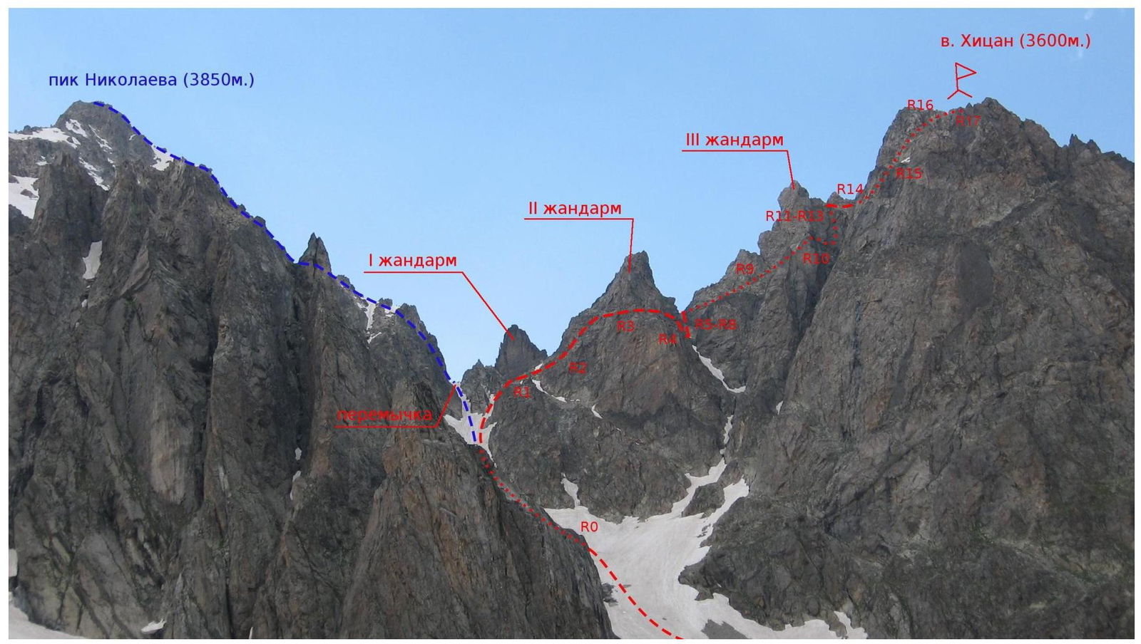
Photo 1. General view of Khitsan summit and its Western ridge from the South. July 9, 2010. Photo taken from the lower plateau of the southern cirque of Tsey glacier from under the northern slopes of Zaramag peak.
The route of the first ascent to Khitsan via the Western ridge from the South is marked on the right.
On the left — the 2A category route via the Eastern ridge to Nikolaev peak.
The visible path of the route is marked with a dashed line, the invisible path is marked with a dotted line.
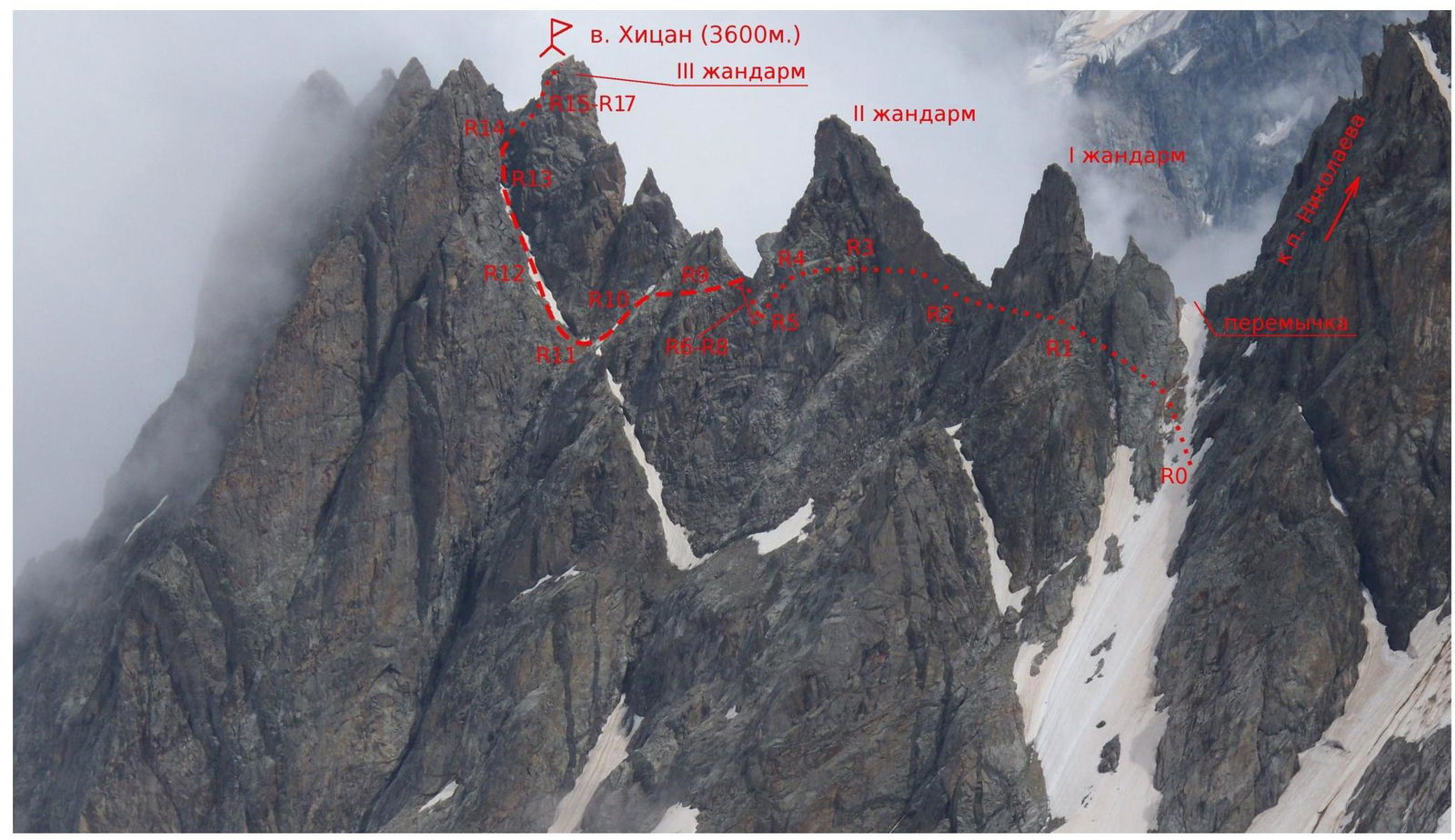
Photo 2. Profile of Khitsan Western ridge from the North-West. July 20, 2010. Photo taken from the upper plateau of the northern branch of Tsey glacier from under the north-eastern slopes of Chanchakhi peak.
The route of the first ascent to Khitsan via the Western ridge from the South is marked on the photo:
- Visible path is marked with a dashed line
- Invisible path is marked with a dotted line.
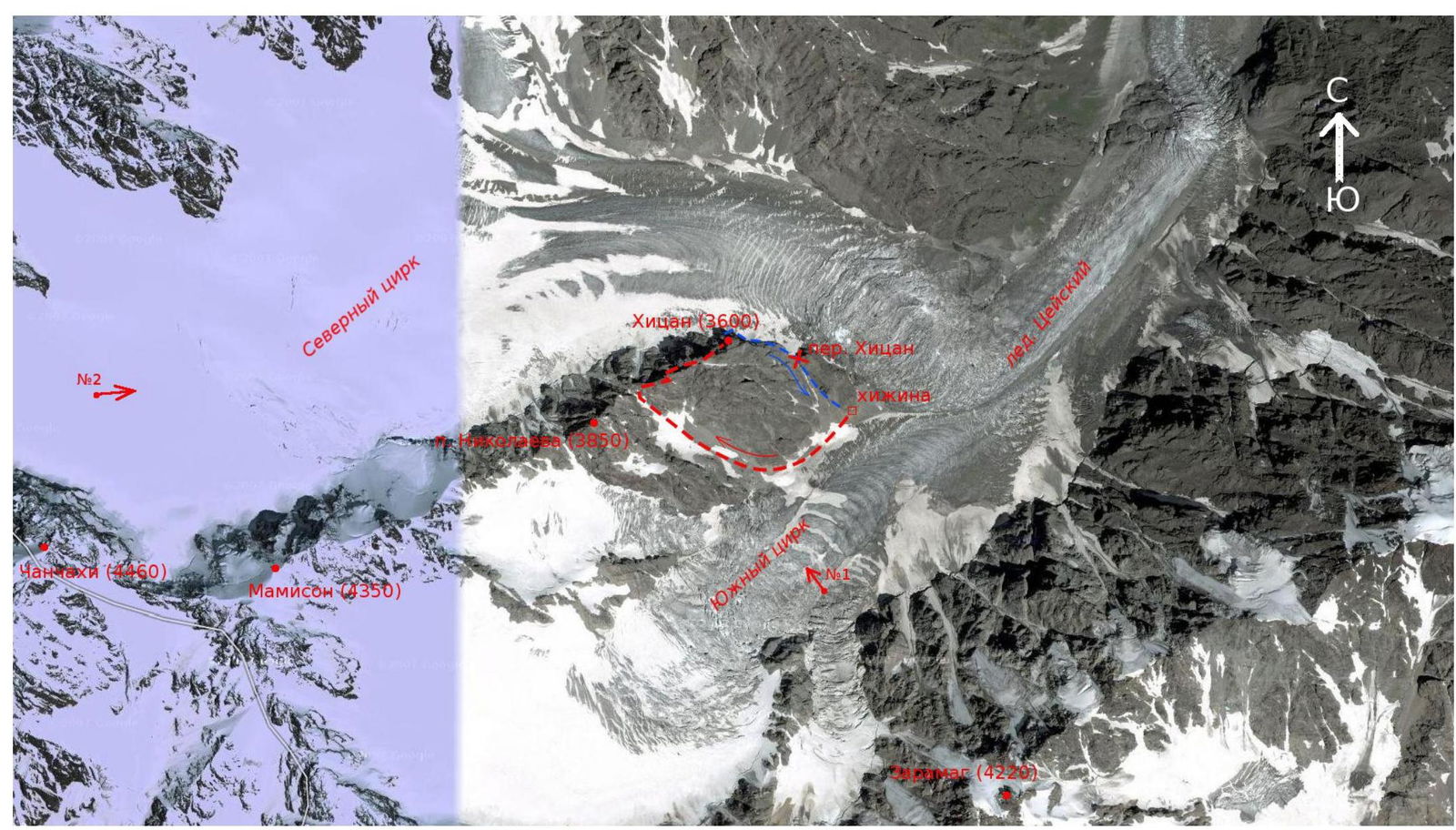
Panorama of the area. The path of ascent to Khitsan via the Western ridge from the South is marked with a red dotted line. The descent path via the 1B category route is marked in blue.
Arrows indicate the points, directions of the shots, and corresponding photo numbers.
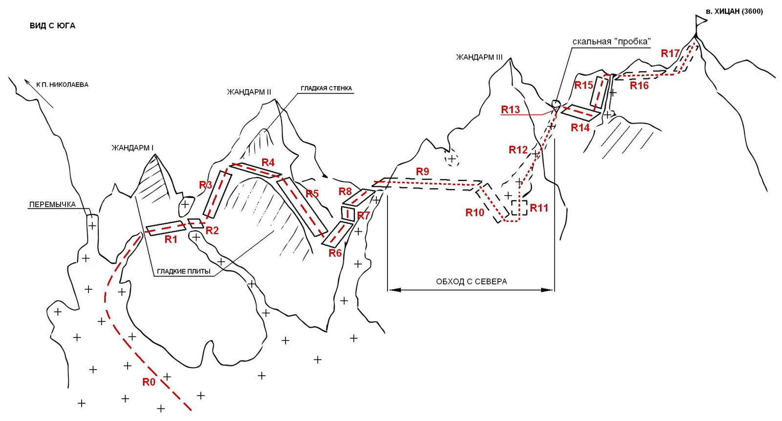
Section Scheme
CHARACTERISTICS OF ROUTE SECTIONS
| Section № | Length | Steepness | Relief type | Category of difficulty | Number of pitons |
|---|---|---|---|---|---|
| 0 | 400 m | 35° | snow | I | 0 |
| 1 | 70 m | 20° | rock | I | 0 |
| 2 | 30 m | 15° | rock | I | 0 |
| 3 | 70 m | 35° | rock | I | 0 |
| 4 | 70 m | 20° | rock | I | 0 |
| 5 | 50 m | 35° | rock | II | 0 |
| 6 | 50 m | 20° | rock | I | 0 |
| 7 | 3 m | 60° | rock | III | 0 |
| 8 | 60 m | 30° | rock | II | 0 |
| 9 | 100 m | 15° | rock | II | 0 |
| 10 | 50 m | 35° | rock | II+ | 0 |
| 11 | 5 m | 30° | rock | III | 0 |
| 12 | 80 m | 40° | snow-ice | III | 0 |
| 13 | 4 m | 60° | snow-ice | IV- | 1 |
| 14 | 40 m | 5° | rock | I | 0 |
| 15 | 20 m | 35° | rock | II | 0 |
| 16 | 40 m | 10° | rock | I | 0 |
| 17 | 30 m | 15° | rock | I | 0 |
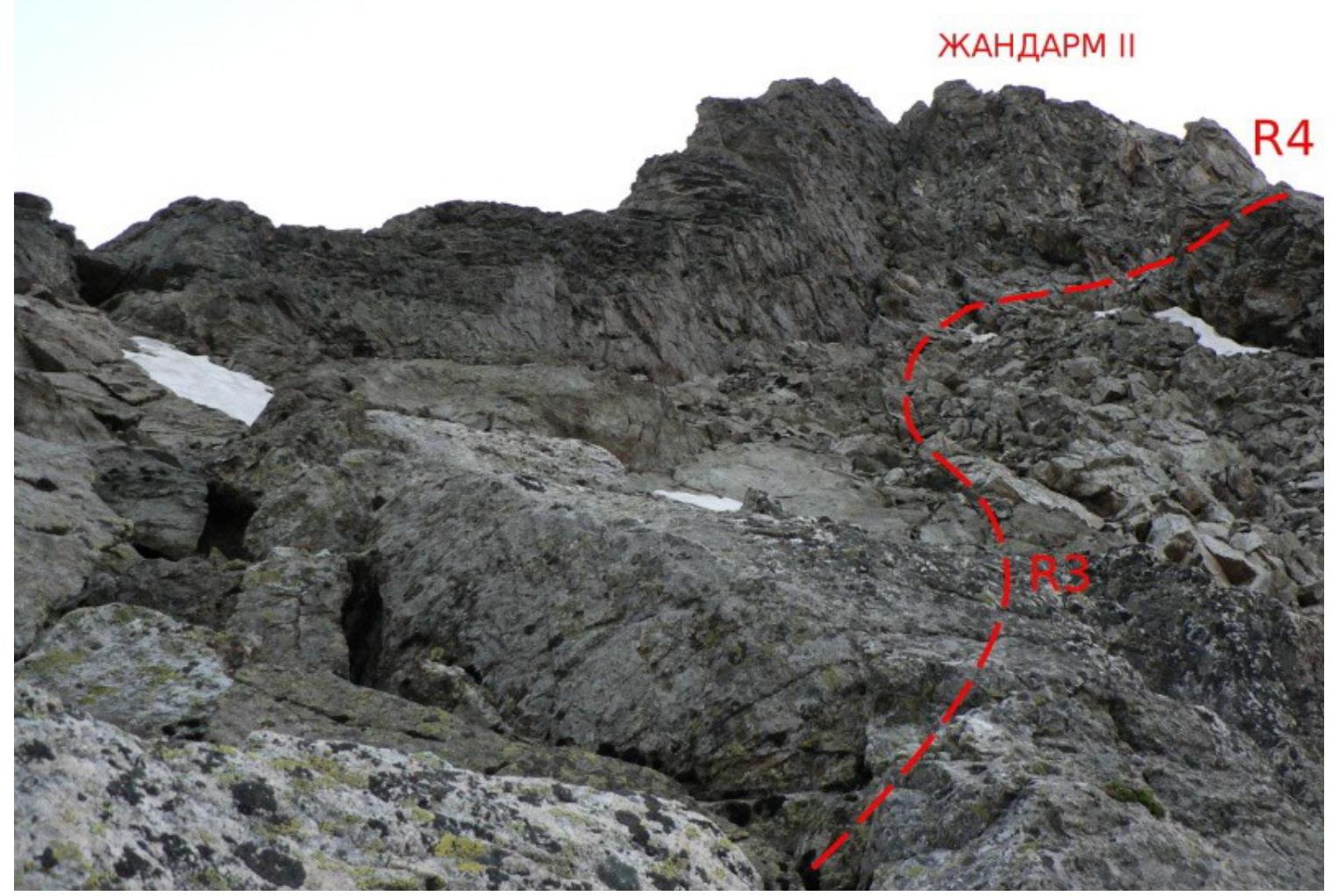
Photo 3. Technical photo of the route. July 9, 2010. Taken from section R2 in the direction of the second gendarme.
Brief Description of the Route
From the Tsey hut, descend to the glacier and along its right part approach the second snowy couloir leading to the saddle between Khitsan and Nikolaev peaks.
Climb the couloir (R0) and in its upper part, 100–150 m before the saddle, turn to the right branch. Without reaching the ridge, turn right onto rocky shelves. From the hut, 1.5–2 hours.
Move along simple shelves parallel to the ridge, without climbing onto it and bypassing the first gendarme from the south (R1). Then, crossing a snowfield (snowy rocks), move diagonally upwards along simple rocks to a longitudinal smooth wall under the second gendarme (R2–R3).
Moving along the wall (R4), reach the shoulder of the gendarme and along simple and medium difficulty rocks (R5), descend to the left edge of the couloir. From here, moving upwards (R6) along the rocks on the left part of the couloir (do not enter the couloir!), overcome a 3 m wall of medium difficulty (R7) and along simple rocky terrain along the couloir, reach the saddle between the second and third gendarmes of the Western ridge of Khitsan (R8). From the hut, 3.5–4 hours.
On the saddle, turn right, traverse along strongly destroyed rocky shelves on the northern side of the third gendarme (R9). Rockfall hazard ("live" stones (slabs))! Move one by one, insurance through ledges!
Further:
- along snowy rocks of medium difficulty, descend to the narrowing (scree shelf!) of the snowy-ice couloir (R10),
- traverse and cross to the rocks on its left side (R11).
Climb the couloir (crampons, insurance through ice axe (ice screws!)) for 70–80 m (R12) to its upper narrow part with rocks wedged between the couloir walls ("cork").
Passing under the "cork":
- overcome a narrow ice wall (3–4 m, 60", insurance using ice screws!)
- leaning on rocks to the left and right, climbing above medium difficulty — key section of the route (R13)
- reach large flat shelves of the Western ridge behind the third gendarme.
Here is a station (for large separate slabs on the right) for organizing insurance and rope protection.
Then move along flat shelves on the southern side of the ridge for 30–40 m (R14) and then along simple rocks (possibly snow) climb onto the ridge (R15). Along simple rocks of the ridge — exit to the summit (R16–R17). From the hut, 6–6.5 hours. Descent via the 1B category route.
In the group's opinion, the passed route corresponds to the 2B category.
Note 1: at the end of summer, the snowy-ice couloir R12–R13 may melt, in this case, the passage of sections R12–R13 may change.
Note 2: possibly, the route on sections R11–R17 coincides with a part of the 3B route via the Northern wall. In this case, as follows from the description of the 3B route, the melted section R12–R13 may represent a "steep earthy couloir", 85 m, III category.
The previous path along the Western ridge to section R11 of our route had no signs of other climbers.
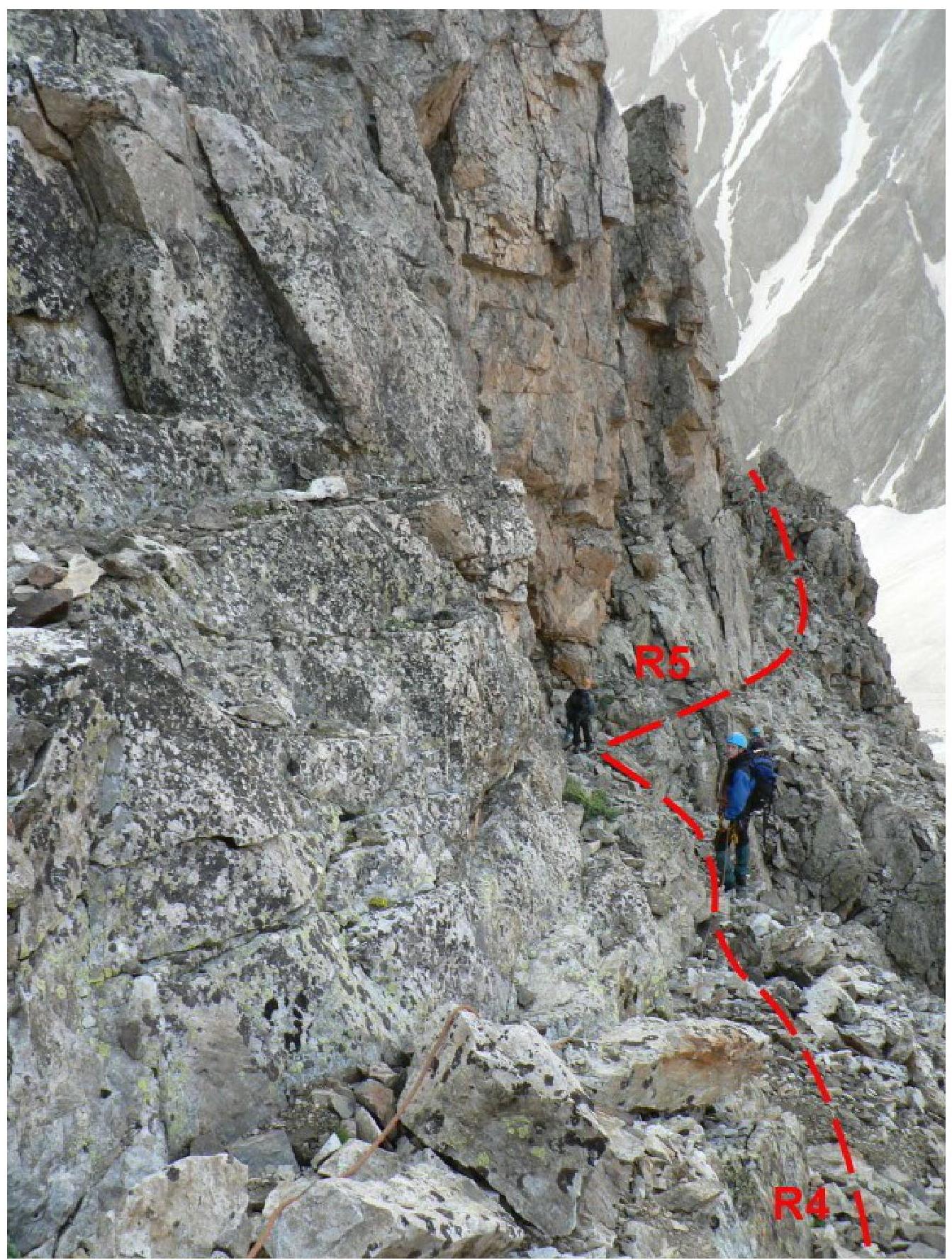
Photo 4. Section R5. Taken from section R4.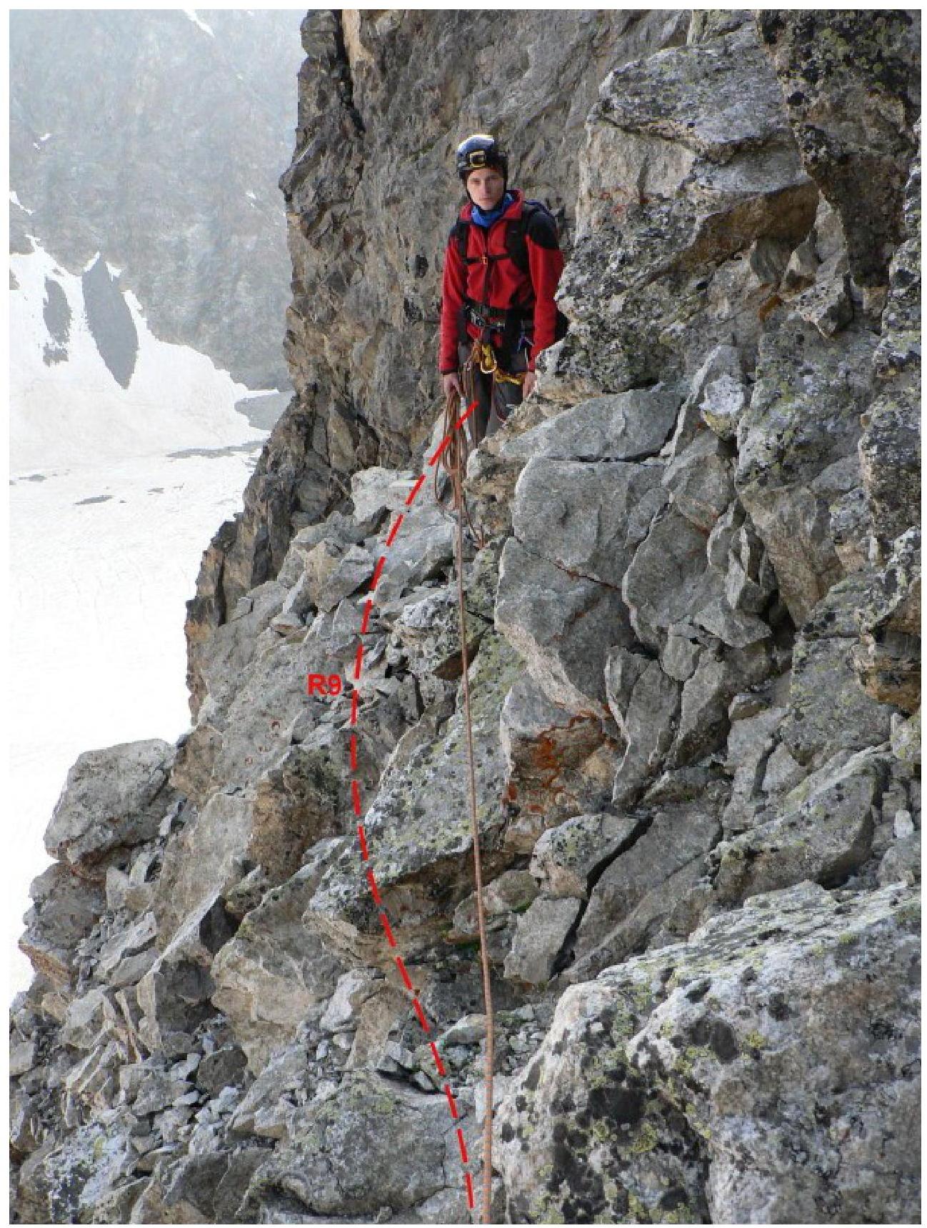
Photo 5. Section R9. Taken from the initial part of R9 in the direction of R10 and the snowy-ice couloir (hidden behind rocks on the right).
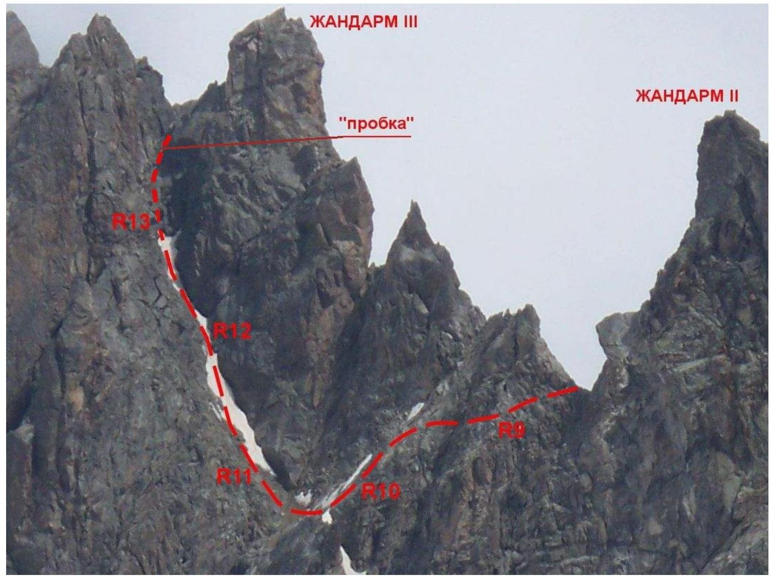
Photo 6. Sections R9–R13. Scheme of the edge of the third gendarme from the North. Photo taken from under Chanchakhi peak (similar to Photo 2). July 20, 2010.
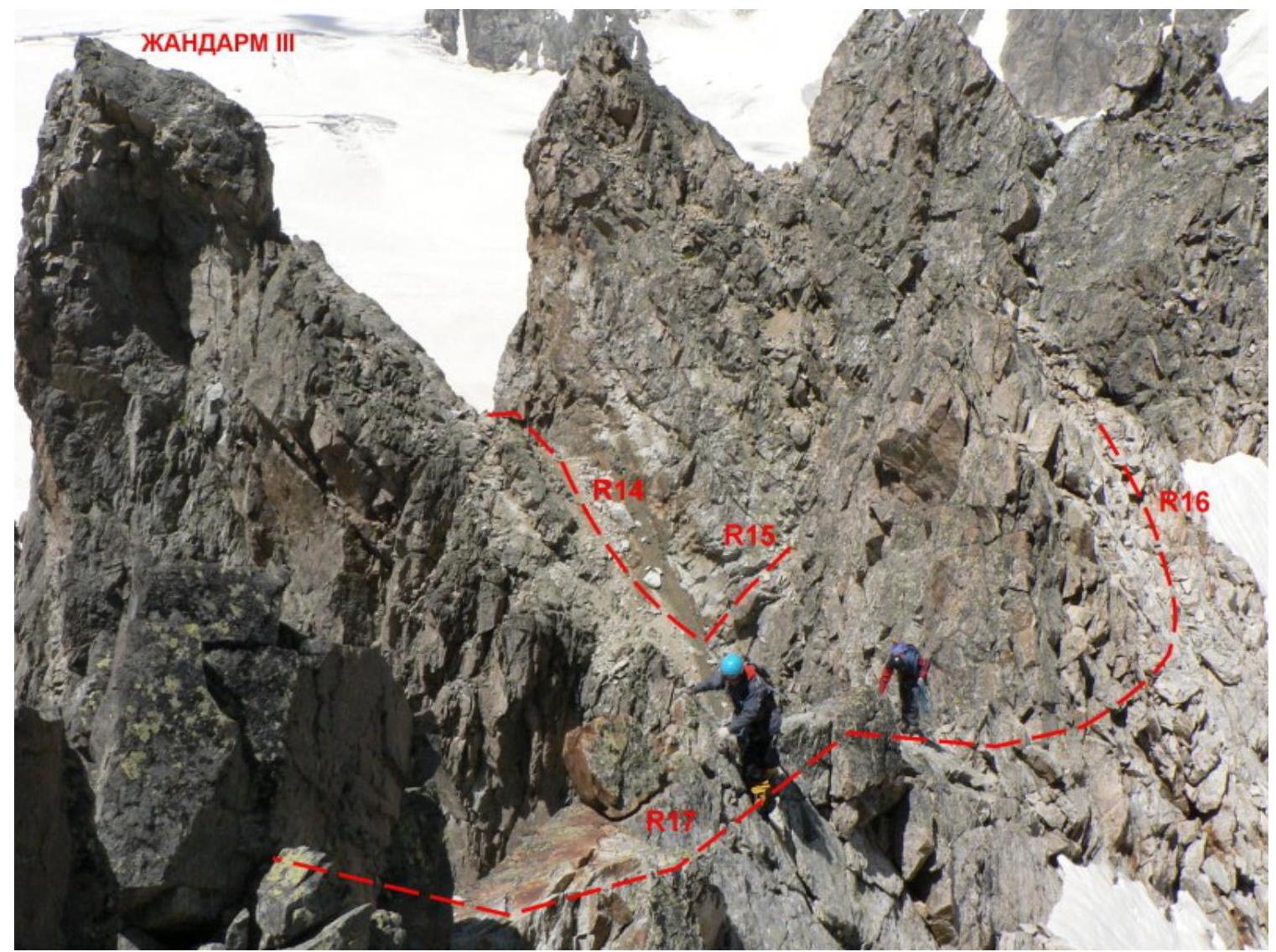
Photo 7. Sections R14–R17. Taken from the summit.
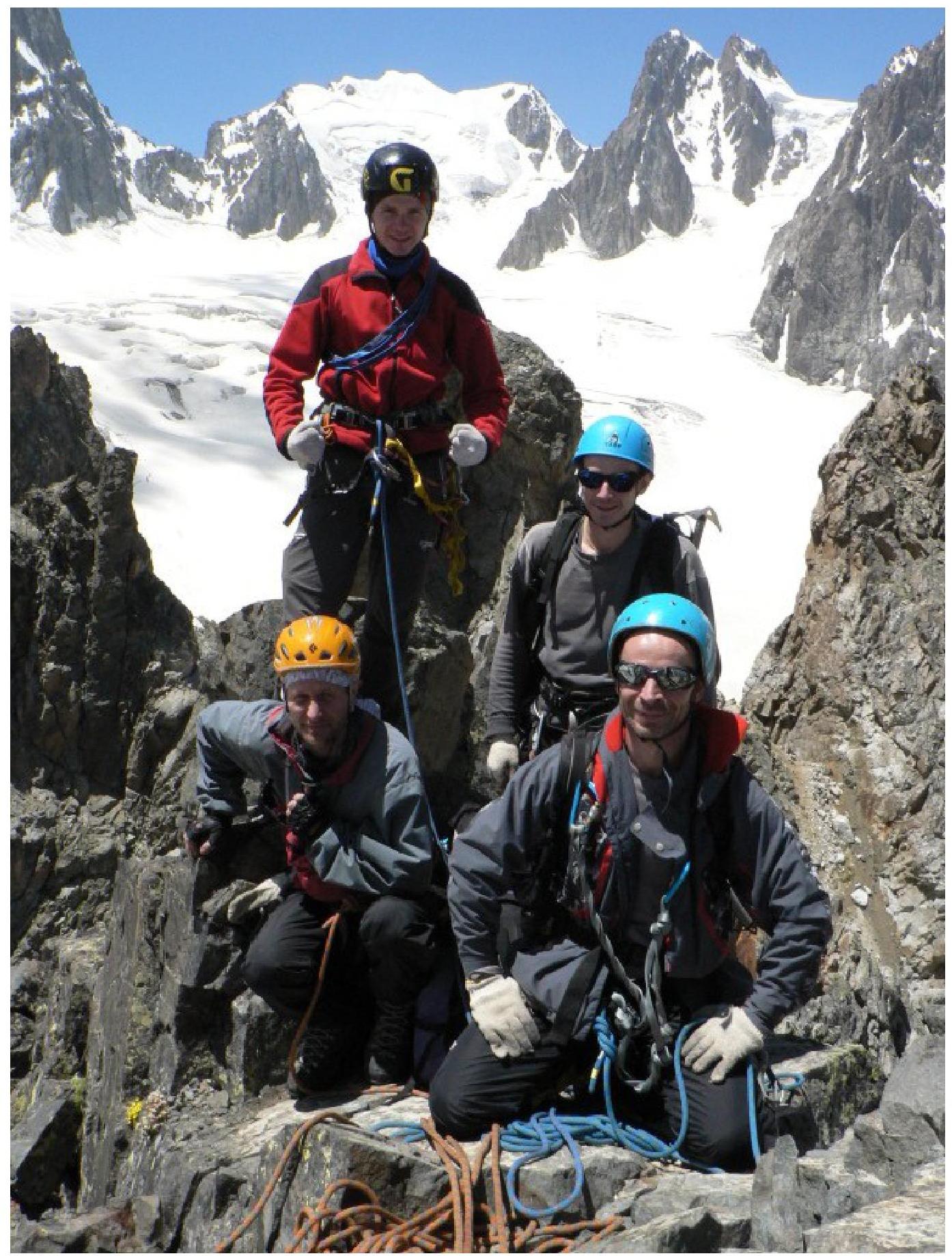
Photo 8. Group on the summit of Khitsan.