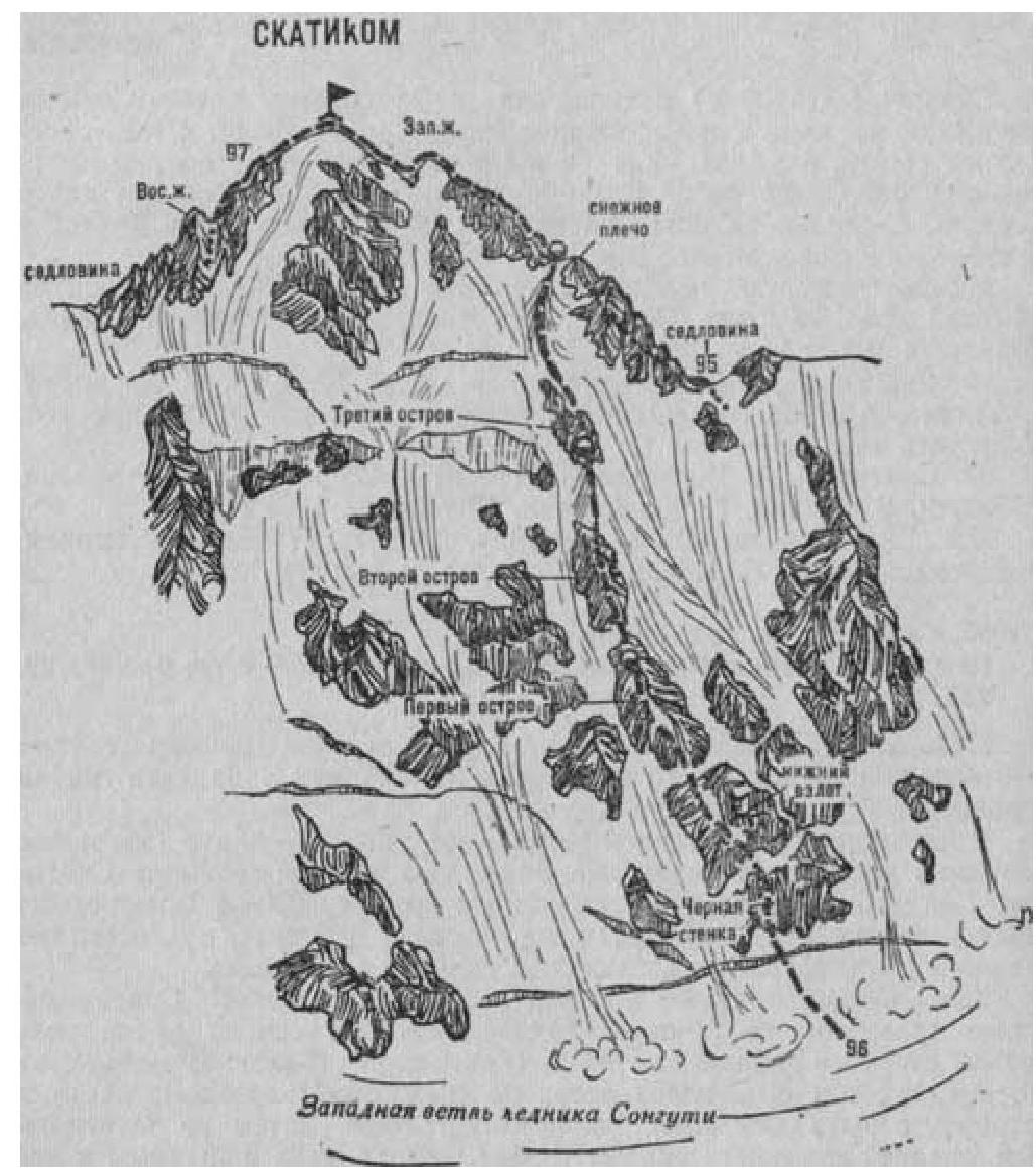
Fig. 23
- Skatikom (4450 m) via North-East Wall (combined route by G. Bukharov, 5A cat. diff., Fig. 23).
From the base camp on the right bank of the Songuti River, near the tongue of the same-name glacier (group of 4–6 people), ascend to the glacier, cross it to the right and exit to the right-bank moraine. Follow the moraine to the "ram's foreheads" and bypass three seracs on the right:
- First serac
- Second serac
- Third serac
Beyond the third serac, exit the rocks to the left onto the glacier and ascend to the upper snow plateau of the Western branch of the glacier along its right side. Follow the plateau to the foot of the North-East wall of Skatikom peak. The initial bivouac is on the plateau under the wall. 6–8 hours from the base camp.
From the plateau, ascend a steep ice-and-snow 60-meter slope with a bergschrund in the middle part to a rock shelf on the left side of the black wall at the base of the North-East wall of Skatikom peak.
From the shelf:
- directly up the rocks of above-average difficulty of the 60-meter black wall;
- then follow a 30-meter steep ice-and-snow slope to exit onto the rocks of the lower ascent.
From here:
- 30 m left - up the rocks of average difficulty of the ascent;
- then follow tile-like rocks of average difficulty, alternating with 2–3-meter difficult walls and steep snow slopes in the middle part, 180 m ascent to the First rock island between the avalanche chute on the left (rockfall along the chute) and overhanging walls on the right.
Ascend rocks of average difficulty of the First island with small difficult sections, 250–270 m to a ledge.
From the ledge, 30 m up rocks of average difficulty. Then follow a steep, narrow 30-meter ice ledge to approach the Second rock island.
Ascend monolithic, with few holds, difficult rocks of the Second island:
- 200–250 m ascent to a steep ice-and-snow ridge;
- 200–250 m along the ridge to approach the Third rock island to the right of ice couloirs.
On the ledge in the lower part of the Third island - bivouac.
12–14 hours from the initial bivouac.
From the ledge, ascend rocks of the island, then a steep ice-and-snow slope, 400–450 m to a ledge on the snow shoulder of the Western ridge of the peak. 4–6 hours from the bivouac on the wall. Further ascent to the summit along the Western ridge is described in route 95.
Descend via the Eastern ridge (see route 97). Duration of the route from the base camp is 3–4 days.
Naumov A. F. Karaugom, Digoria, Tsey (Central Caucasus), M., "Fizkultura i sport", 1976.