Ascent Passport
- Caucasus, Sugansky Ridge, Classification section number 2.6.
- Gabueva Mahara peak (4160 m) — from the South, via the Southern edge.
- Proposed category: 2B, first ascent.
- Route type — combined.
- Route elevation gain — about 700 m (from point R0).
Total route length — about 1800 m. Length of sections with 5th category difficulty — 2 m. Steepness of key sections — up to 90°. Average steepness of the entire route — 40°.
- Pitons left on the route — none.
Number of used rock protection — 7.
- Climbing hours — 5; days — 1.
- Leader: Egorin S. V. — Master of Sports
Team members:
- Ryzhanov O. N. — Candidate for Master of Sports
- Makarkina O. — 2nd sports category
- Coach: Akhtyrchenko G. V. — Master of Sports
- Route entry date: August 8, 2006
- Organization: AUSB "Digoria"
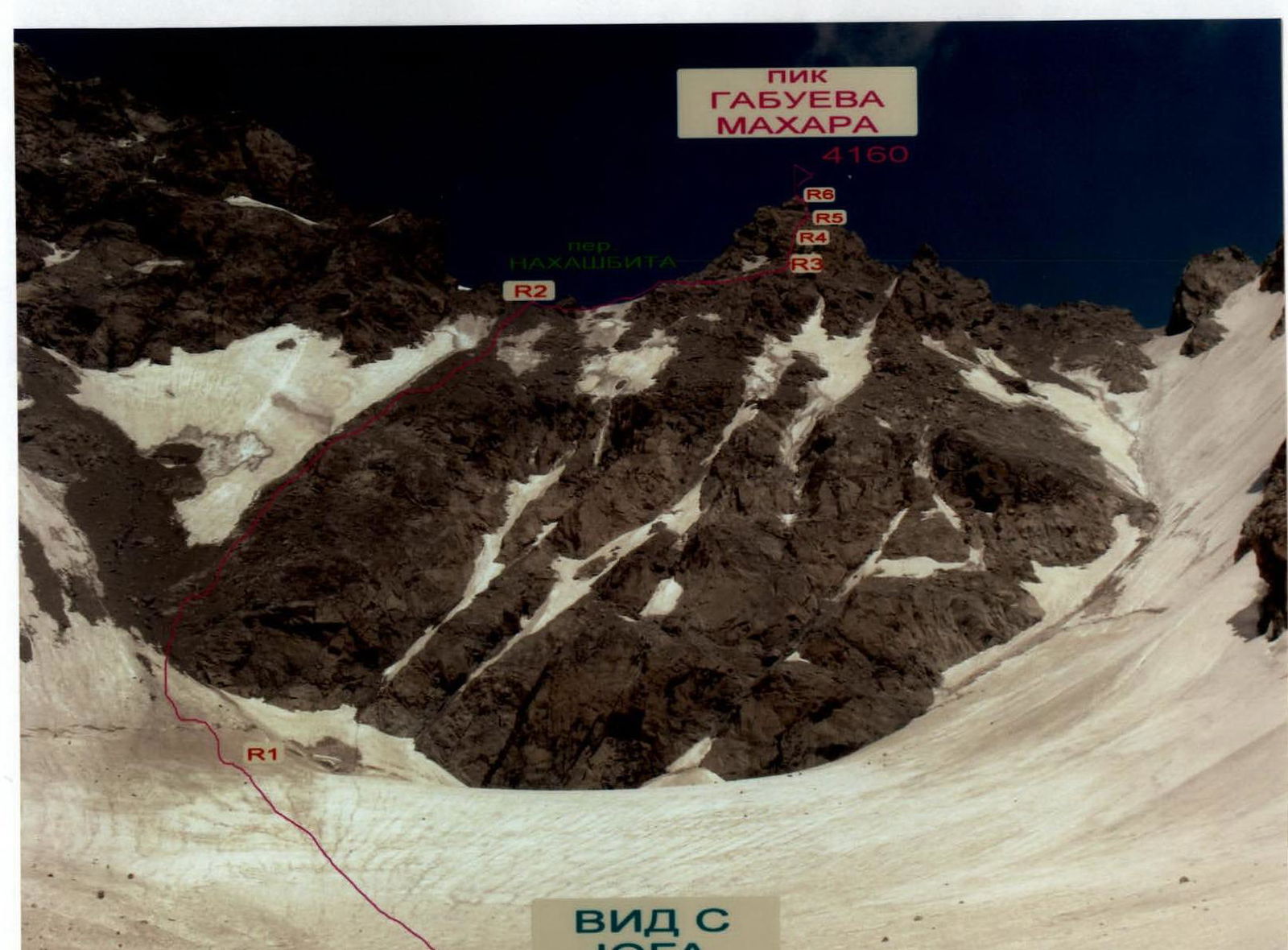
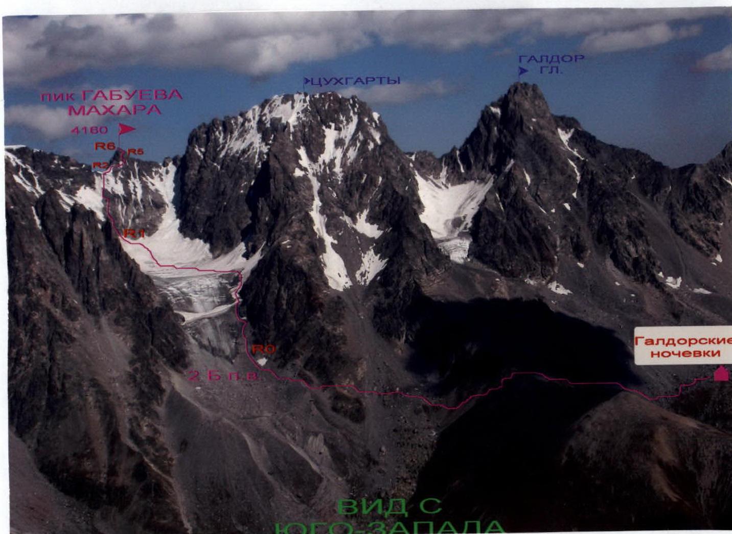
General view of the summit
Marked:
- In red — the first ascent route.
Brief overview of the ascent area
The ascent was made in the Sugansky Ridge. It stretches in a latitudinal direction for almost forty kilometers.
The Sugansky Ridge is located between the rivers:
- Cherek-Balkarsky to the West
- Uruh (Iraf) to the East
Its southern slopes are located on the territory of the Republic of North Ossetia–Alania, and the northern ones — mainly on the territory of the Kabardino-Balkarian Republic.
Characteristics of the ridge:
- Average peak heights — about 4000 m
- Highest peaks — almost reach 4500 m, rising 1000 m above the snow line
- All passes, even the lowest and relatively accessible ones, are located above 3300 m
- In the central part of the ridge, passes are above 3700 m
The Sugansky Ridge is composed of ancient rocks: light gray granites of the Paleozoic and dense, highly metamorphosed clay shales of the Lower Mesozoic. The southern slopes of the ridge start with numerous ridges, edges, and counterforts, partially destroyed, between which there are short, receding, cirque glaciers of southern exposure.
Below are:
- numerous scree slopes
- moraines from retreating glaciers
At heights below 3000 m, alpine meadows with a large number of various grasses and flowers that bloom luxuriantly in summer begin.
The climate of the region is typical for the Caucasus — with a maximum of precipitation in the summer months and an average annual norm of 1500–1600 mm of precipitation. Summer at heights above 2500 m is short and relatively cold (average daily temperature in July–August +16°). Winter lasts from November to March, frosts can reach –40°. There is relatively little precipitation, but after prolonged snowfalls, the approaches become avalanche-prone.
The southern slopes of the Sugansky Ridge are well освоited by climbers, who have laid dozens of routes here from 1B to 5B category difficulty. Ascents from the north differ:
- by longer approaches
- by more severe conditions
Therefore, they are less frequent, and most of the northern slopes are still waiting for their pioneers.
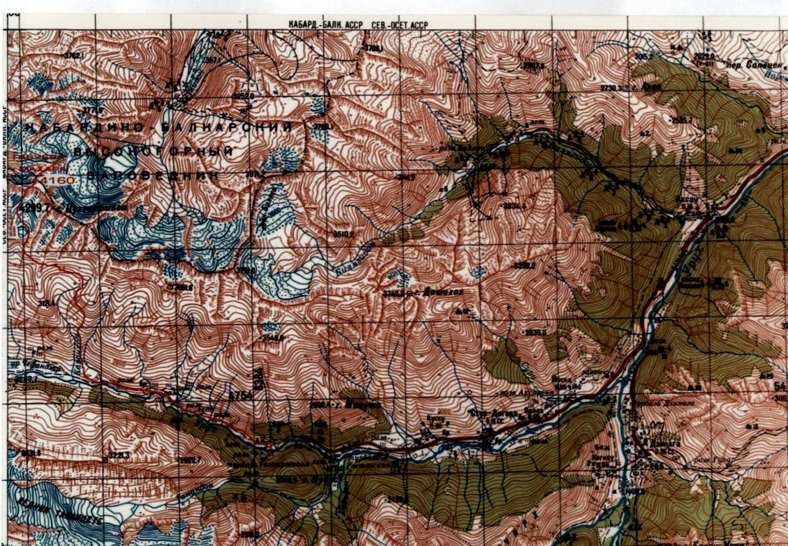
Ascent area map
Marked: in red — approach paths and route.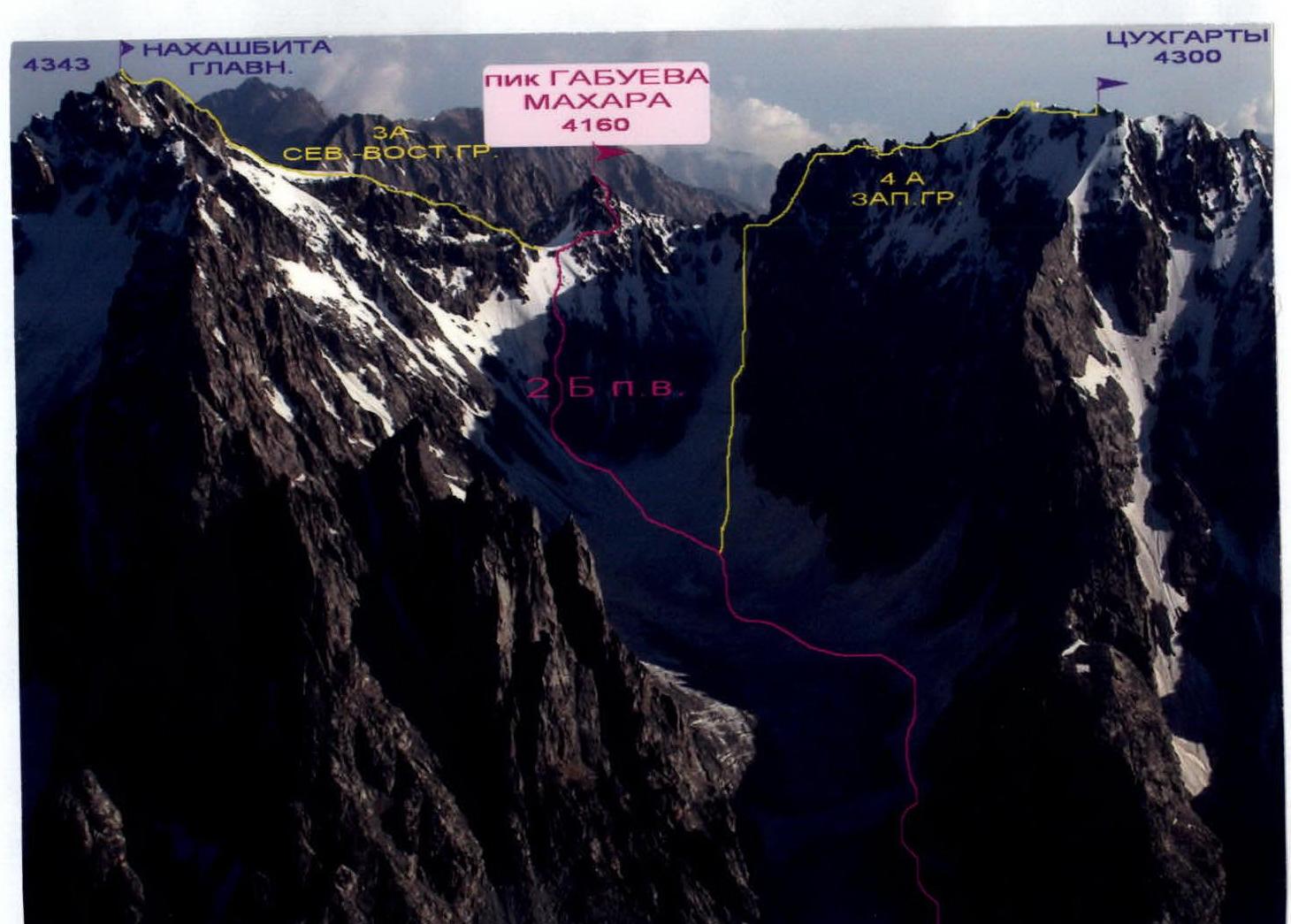
Ascent area photopanorama
Marked:
- In red — the first ascent route.
- In other colors — classified routes to neighboring peaks.
Description of approaches to the route. To Galdor bivouac
After leaving the Digoria alpine camp (Komy-Art sports and recreation camp), cross the Khares River by bridge. Then start climbing westward up the gorge — along the trail, then along the road. After an hour, having passed the border post (documents may be checked) and passed the waterfall by the road (Aikhvadon River), come out onto a trail among the meadows. Along this trail, crossing a couple of streams flowing from the right, 30 minutes after the waterfall, come to a fork in the trails. Then go along the upper trail, and after another 30 minutes, come to the "Agibalovka" stream, flowing from the southern slopes of the Sugansky Ridge from under the peaks of Agibalova and Akritov. Having crossed this stream, turn right and then go north, starting to climb along a wide grassy slope. The ascent path goes up to the left towards the left edge of this slope. There is a trail here, winding between, and in places along, outcrops of несложных slate rocks. Caution! To the left is a steep grassy slope, ending in the Galdorka River. It originates from under the Galdor massif, and one of its tributaries flows through the Galdor bivouac. After the first steep ascent, the slope's steepness decreases slightly, and it narrows to a ridge, and then goes with small ups and downs. When outcrops of destroyed rocks appear on the slope of this ridge to the left, it is necessary to start traversing left with a slight gain in height, gradually entering the Galdorka gorge. Here, in places, a trail is visible on the slope. Then we ascend along the stream, bypassing a rocky step with a small waterfall to the right. Above 3000 m, there is less and less grass on the slope, and then we go along a scree slope, turning slightly to the right. To the left below, in a small gully, a stream flows — one of the tributaries of Galdorka. We follow it until a convenient crossing over the gully appears; at this point, a white scree slope is visible on the slope to the right, and green areas among the jumble of rocks are visible to the left behind the stream — this is the Galdor bivouac. Having crossed the gully, we come to the bivouac under a rock with a plaque. The height here is 3128 m. GPS coordinates in WGS-84 format: N 42°56.312′ north latitude and E 43°31.135′ east longitude. From the alpine camp, it takes about 6 hours on foot. Elevation gain is 1300 m.
In the second half of August, when the snowfields above melt, there may not be a stream at the bivouac. Then it is necessary to go further north, towards Galdor Glavny, under a large scree slope on the slope. Before reaching it, there are still areas for bivouac and a stream.
Description of the ascent route
From the Galdor bivouac, go north, towards Galdor Glavny, for about 5 minutes. Then turn left and go west, traversing the scree moraine slope. It is necessary to go towards a specific-shaped gendarme "Ushi", located in the ridge separating the Galdor bivouac and the Nakhashbita meadow.
Having reached the col (3300 m) to the left of the gendarme along the scree slope (about half an hour from the bivouac under the plaque), descend 150 m. Then start traversing the southern slopes. After reaching a regrowing moraine ridge, go up it a little, and, having found a suitable place to descend along a conglomerate slope, go down to the left. After descending, we come to scree slopes formed after the retreat of the glacier descending to the south between the peaks of Nakhashbita Glavny to the left and Tsukhgarta to the right. We approach the "ram's foreheads" to the right of the glacier tongue.
Time on the path:
- From Galdor bivouac: 2–3 hours
- From Nakhashbita meadow: 1–1.5 hours
Section R0–R1. Along the rocks of the "ram's foreheads" and along the ledges between them, go first straight, then up to the left. Attention! Belaying is necessary — on rocks and ledges. There is sand and stones on them after the retreated glacier. Rockfall is also possible from the rocks!
After passing the "ram's foreheads":
- Go along the snowy slope, to the right of the zone of breaks and crevasses of the glacier.
- After reaching the glacier plateau, cross it in the center, towards the visible peak 4160 m ahead.
- Several counterforts descend from the summit to the south; we approach the base of the left one.
The entire section is about 1 km; 1–2 category difficulty (rocks in places 3 category difficulty), terrain from 10 to 50°.
Section R1–R2. We bypass the base of the left counterfort from the left along the snowy slope. We cross the bergschrund in its right part through a snow plug. Then go up along the snow-ice slope (crampons may be needed). Rockfall is possible from above!
After about 200 meters:
- Turn right onto the rocks of the southern counterfort.
- Along this counterfort, along its left part, go up along the rocks of 2–3 category difficulty.
- After the rocks end, go along the snow-ice, possibly scree, slope to the Sugansky Ridge col — Nakhashbita pass (4030 m).
The entire section is about 0.5 km. Terrain 30–50°.
Section R2–R3. From the pass col, the double tower of Gabueva Mahara peak is clearly visible. The highest point is the northern tower. To climb it, it is necessary to leave the pass and go traversing to the east along a vaguely expressed terrace. Along the rocks of 2 category difficulty, we reach, after 150 m, a narrow couloir and, without descending into it, turn left. This is the Southern edge of peak 4160 m.
Section R3–R4. Along the rocks of the Southern edge straight up. Walls 3–4 category difficulty, 60–80°.
In the middle of the section, there is a bypass of a small overhang to the right along the wall:
- 5 category difficulty
- 90°
- 2 m
At the end of the rope, come out onto a scree ledge leading to the right. The entire section is 50 m.
Section R4–R5. Along the scree ledge, bypass the southern tower of the peak to the right and come out under the edge of the northern tower. Section 50 m, 1–2 category difficulty, 20–30°.
Section R5–R6. Along the edge of 3–4 category difficulty, climb to Gabueva Mahara peak. Section 50 m, 50–70°. From the start of the route, 5–6 hours. Descent is along the ascent route.
No signs of human presence were found on the summit. We propose to name peak 4160 m Gabueva Mahara peak:
- in memory of the climber Gabuev Mahara,
- who did a lot for the development of mountaineering in the Digor gorge and North Ossetia.

Technical photograph of the route
The route is marked by sections.
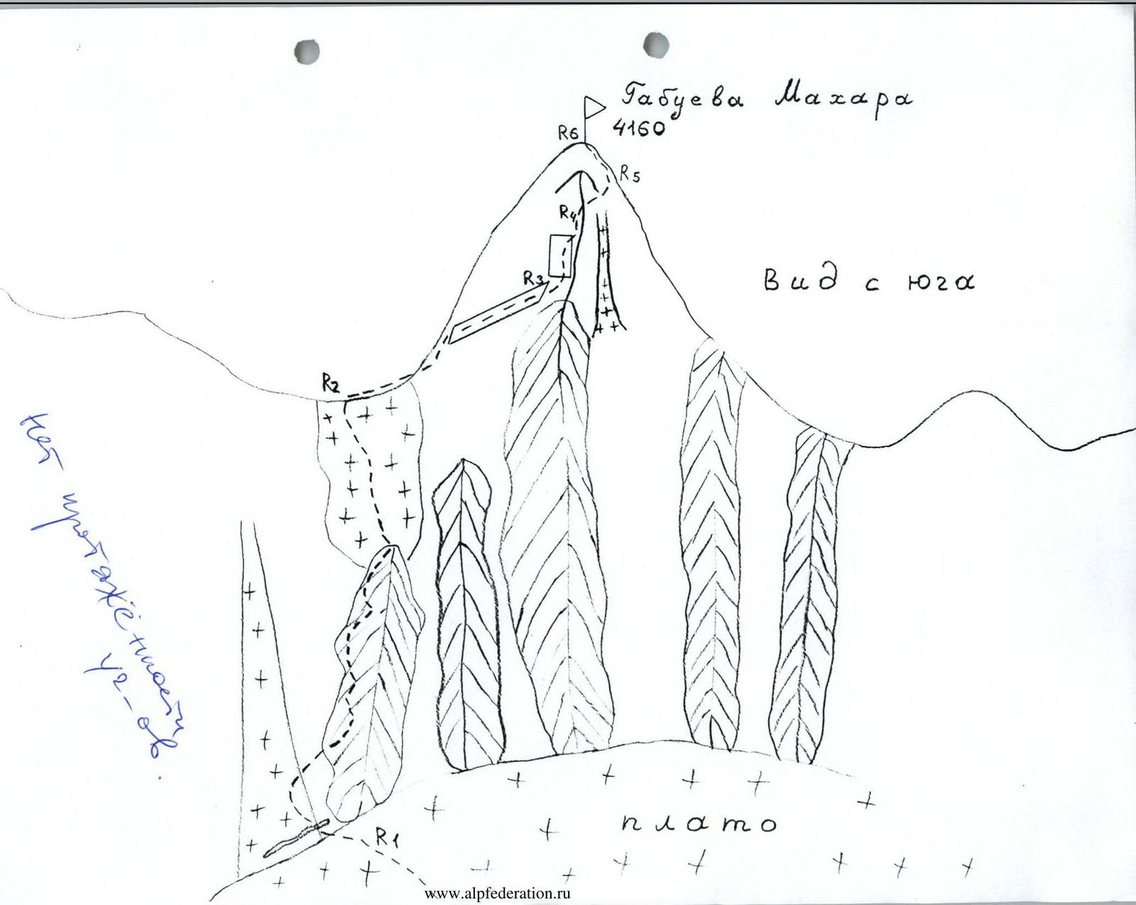
Route profile from the left
The route is marked.
Conclusions and recommendations for the route
The route corresponds to the declared category difficulty. It can be recommended for passage by training and sports groups.
Passing the route allows you to practice rope work skills.
The rocks on the route are местами bлочного типа, so it is recommended to have with you:
- a set of rock protection.
At the beginning of summer, in couloirs, there may be a hard snow slope early in the morning. Therefore, it may be necessary to take with you on the route:
- crampons.
You can start the route from both the Galdor bivouac and the Nakhashbita meadow. We went from the Galdor bivouac. To have time to complete the ascent with this option, it is necessary to start the ascent at night and have headlamps for everyone in the group.
GPS coordinates of Nakhashbita meadow (2835 m) in WGS-84 format:
- N 42°56.090′ north latitude,
- E 43°29.540′ east longitude.
When moving along scree couloirs, it is necessary:
- to go in a dense group,
- so as not to knock stones down on each other.
On the route, belaying is necessary on sections of 2 category difficulty and higher. On the ridge, it can be done:
- through numerous outcrops,
- through pitons,
- through rock protection.


