Traversing p. Akritov (3705 m) — p. Agibalova (3705 m) from E.
Caucasus, Sugansky ridge
Strebejev V.N.
July 20, 2002
Passport
- Technical category
- Caucasus, Digoria, Sugansky ridge
- Traversing p. Akritov (p. 3705 m, E) — p. Agibalova (p. 3705 m, W), from E.
- Suggested — 3B cat. diff. rock
- Height difference 900 m, length 1150 m. Length of sections 3A–3B cat. diff. 200 m (E. walls of p. Akritov and p. Agibalova, "ridge-knife"), 4A cat. diff. — 35 m (E. walls of p. Akritov and p. Agibalova), average steepness of the main part of the route (E. walls of p. Akritov and p. Agibalova) — 70°.
- Pitons hammered on the route — 18 pcs., used chocks — 12 pcs., left pitons on the route — (1 pc. not removed), no previously hammered pitons.
- Team's walking hours: ascent 8 h (from campsite), descent 2.5 h (via W. ridge).
- Overnight stay — one in the scree cirque under the massif of p. Botkin (Botkin campsite).
- Leader: Strebejev V.N. — 1st sports category, Rachkovsky S.V. — 2nd sports category, Ponomareva I.Ya. — 2nd sports category, Kaloshin O.A. — 2nd sports category.
- Access to the route — July 19, 2002 (approach to campsite). Summit — July 20, 2002 (ascent). Return — July 20, 2002 (descent to base).
- Organization — "Digoria" alpine base.
Route description: traversing p. Akritov — p. Agibalova from E., 3B cat. diff.
The rock massif, which includes two peaks with a height of 3705 m, of which it is proposed to name the peak on the Eastern side as peak Akritov, and the peak on the Western side — peak Agibalova, is located in the Sugansky ridge of Digoria between peak Botkin in the west and peak Uruimagova in the east (photo #1).
I.P. Akritov — one of the first masters of sports of the USSR in alpinism in North Ossetia, for many years:
- head of the training department of the "Torpedo" alpine base;
- head of the KSP of the Digor region;
- organizer of the public rescue team in Ossetia.
V.V. Agibalova — former head of the team for studying dangerous geological processes, author of books describing tourist routes in Digoria.
Exploration of the massif of peaks Akritov — Agibalova was carried out by various groups of the "Digoria" alpine base in the period 1994–2001.
From the "Digoria" alpine base, move up the road past the Big Waterfall, and then along the trail passing along the grassy slopes of the right bank of the Khares River. After 2–2.5 hours, the trail descends and leads to a large clearing ("football field") with large stones — blocks along its left edge. Descend to the clearing and cross it, moving forward parallel to the steep grassy slopes on the right, approach the stream (do not cross the stream), flowing from the first canyon cutting through these slopes.
(From this point onwards, the second canyon formed by the stream flowing from the Galdor glacier is visible, along which the trail leads to the Galdor campsite. From the Galdor campsite, it is also possible to pass the described route, and it is necessary to move from the Galdor campsite to the Botkin campsite through the dividing grassy ridge).
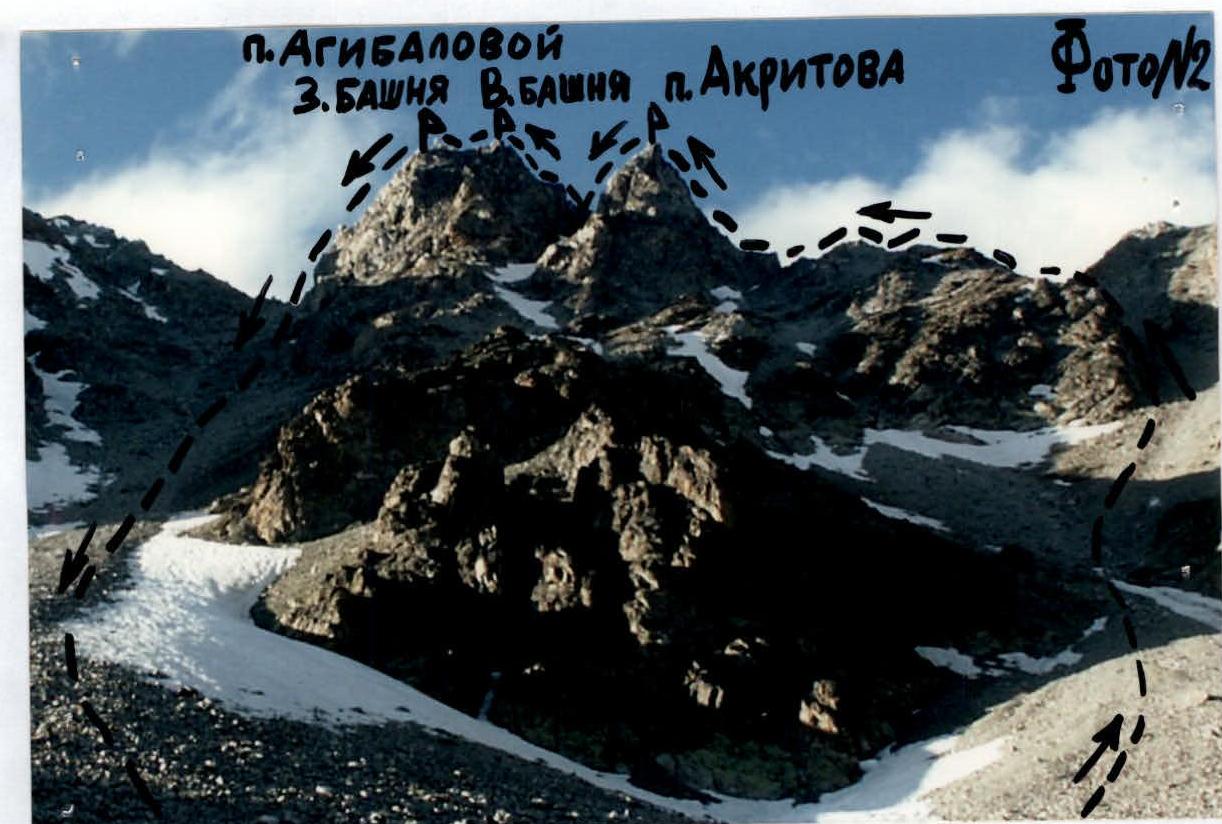
Leaving the first canyon on the left, along its edge, ascend straight up along the scree and grassy steps, trodden by livestock. Pass the steep part of the ascent, after which the massif of peaks Akritov — Agibalova opens up, having characteristic outlines (photo #1, photo #2).
In the direction of the peaks:
- traverse the grassy slopes in their middle part, always leaving the canyon on the left;
- go around on the left below the large rock outcrops in the form of "gates";
- along the green slopes and scree, approach the scree cirque under the massif of peaks Akritov — Agibalova.
Here, on the border of grass and scree, the Botkin campsite is located (photo #3). From the "Digoria" alpine base 5–6 hours.
From the bivouac located at the Botkin campsite, ascend along the wide, partially snowy and scree couloir between peak Akritov and peak Uruimagova, ascend to the saddle (from bivouac 2.5–3 hours).
The upper part of the couloir:
- steep;
- with outcrops of destroyed rocks (stones!);
- stick to the left side.
From the saddle, turn left and, moving along the destroyed ridge, overcoming the walls of four consecutive gendarmes head-on, approach the wall of the tower of peak Akritov (photo #4).
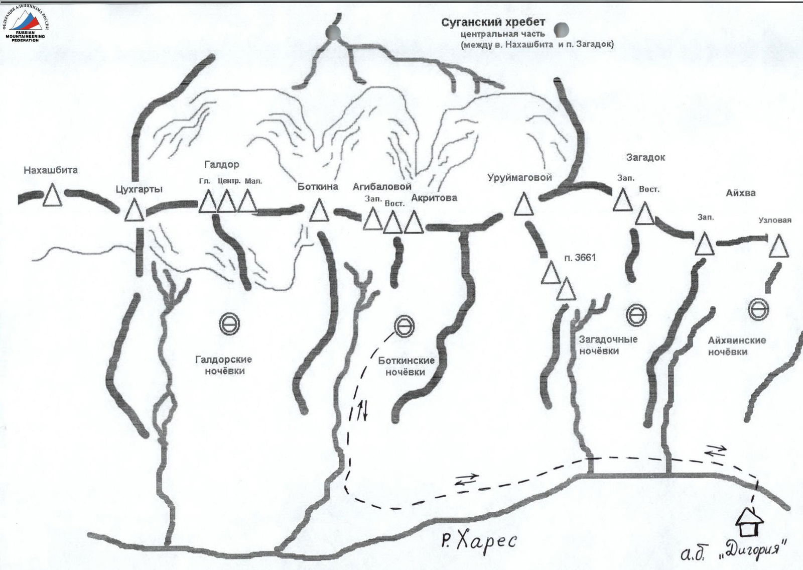
 Section of the Sugansky ridge between peaks Botkin and Uruimagova
Photo # 1
Section of the Sugansky ridge between peaks Botkin and Uruimagova
Photo # 1
 Massif of peaks Agibalova and Akritov
Photo # 2
Massif of peaks Agibalova and Akritov
Photo # 2
 Botkin campsite
Photo # 3
Botkin campsite
Photo # 3
The key Eastern wall of the peak is passed from the rock "tooth" in its lower part, under the protection of which it is convenient to organize an insurance station, along a smooth wall 8 m of medium difficulty in the direction left — up to a wide crack going up the wall. Further along the crack 20 m climbing above medium difficulty ascent to a narrow, pronounced chimney. Enter the chimney, the steepness of the wall here approaches the vertical, climbing is difficult 7 m, then through a нависающий участок 1 m, exit the chimney to the right in the direction of the internal angle with a crack 8 m, leading up to the bend of the sheer part of the wall.
Along the internal angle above medium difficulty, rise to a shelf, behind which the wall begins to bend, here is a convenient platform for organizing an insurance station.
From here, move up through three consecutively located, difficult to pass gendarmes, in the direction of the summit tower of the peak:
- the first smooth "reddish" gendarme is bypassed on the left along an inclined throwing shelf 7 m (carefully, insurance from the station!);
- then ascent to the right — up the wall 6 m of medium difficulty with exit to the second gendarme;
- the third gendarme overcome head-on and along the steep sheer wall of the summit tower 5 m, rise to peak Akritov.
From the summit, descend by rappel 45 m in the direction of the saddle before the Eastern tower of peak Agibalova. Along the monolithic ridge with a wide platform, then descending into the gap 5 m and rising to a narrow ridge, approach the base of the wall of the Eastern tower (photo #5).
Along narrow inclined shelves (pitons insurance) traverse the wall left — up, overcoming:
- smooth wall 15 m of medium difficulty;
- internal angle 10 m,
and exit to a narrow horizontal shelf in the center of the wall.
From the shelf straight up along the center of the wall pass:
- wall 15 m of medium difficulty;
- internal angle 6 m;
- not obvious ridge of the wall with an external angle 10 m.
Having overcome a smooth steep wall 7 m above medium complexity, exit to a shelf in front of the summit tower.
Along a vertical, above medium complexity internal angle 8 m, rise to the summit of the Eastern tower of peak Agibalova.
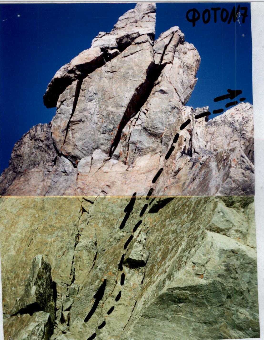
From the tower along the shelves of the steep wall and the internal angle with good footholds descend in the direction of the sharp rocky ridge — "knife" (photo #6), leading to the Western tower of peak Agibalova.
Along the 25-meter smooth "psychological" ridge — "knife", along its left side and along the top — approach the high gendarme "Finger", which is bypassed on the left along the walls and inclined shelves and exit to the Western tower (photo #7).
Passing the route:
- smooth 12-meter wall of the tower is overcome head-on and along the internal angle;
- further — along the destroyed ridge exit to the Western summit of peak Agibalova (3705 m);
- from the saddle of the ascent couloir — 6–7 hours.
Descent:
- along the Western simple, destroyed, sharp ridge, along its right side — to the saddle between peak Botkin and Agibalova;
- from the saddle — along the scree and snow couloir descend to the Botkin campsite.
For a group of 5–6 people, passing the route takes 10–11 hours.
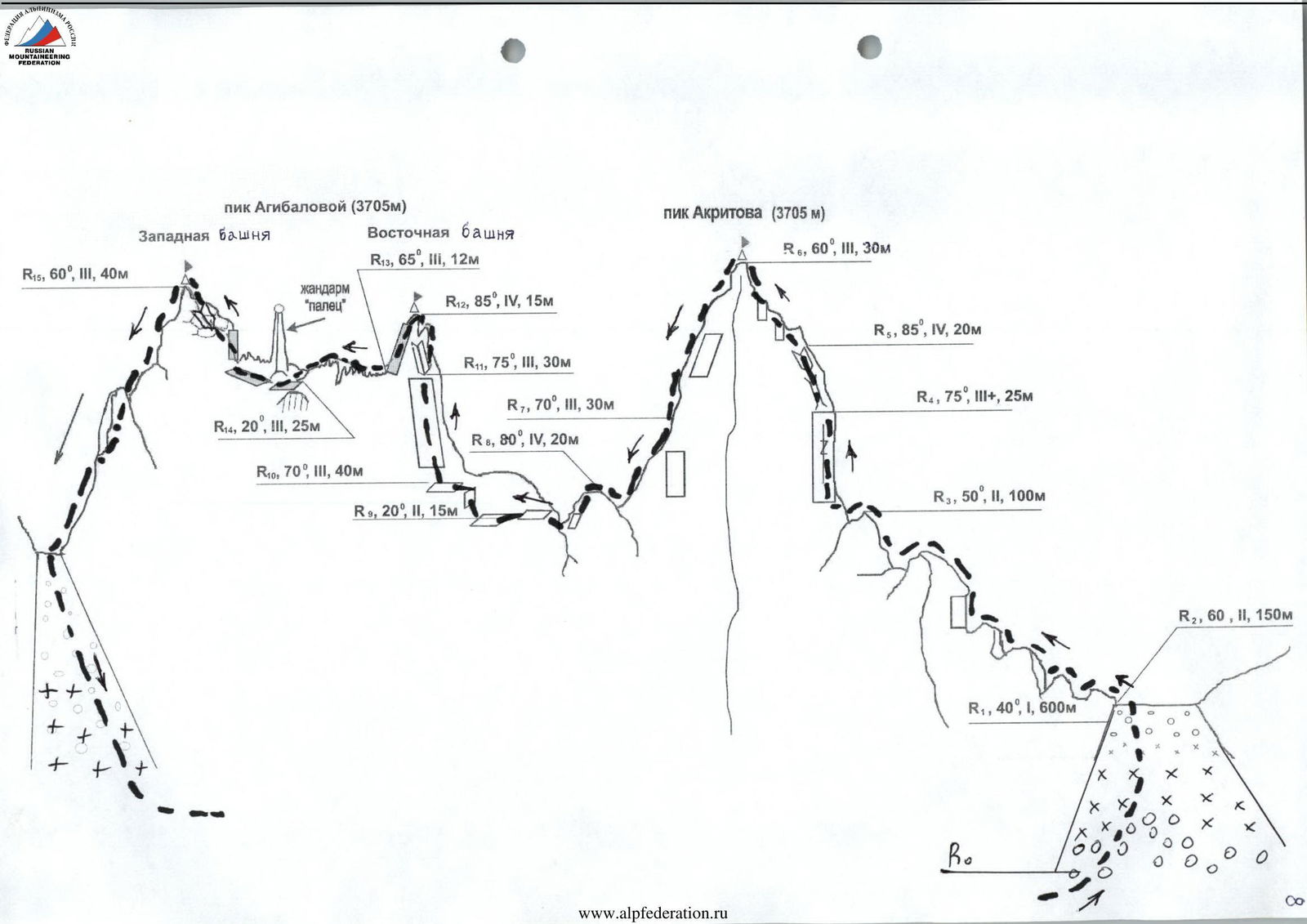 Table of main characteristics of the ascent route sections
| № section | Steepness, deg | Length, m | Character of relief | Category of complexity | Insurance |
|---|---|---|---|---|---|
| R0–R1 | 40 | 600 m | Scree, snowpatch in couloir | 1 | Simultaneous with ice axe |
| R1–R2 | 60 | 150 m | Scree, snowpatch, destroyed rocks | 2 | Simultaneous |
| R2–R3 | 50 | 100 m | Walls of gendarmes | 2 | Simultaneous for ledges |
| R3–R4 | 75 | 25 m | Wall with crack | 3 | Pitons, chocks |
| R4–R5 | 85 | 20 m | Chimney, internal angle | 4 | Pitons, chocks |
| R5–R6 | 60 | 30 m | Inclined shelf, walls of gendarmes | 3 | Pitons, ledges |
| R6–R7 | 70 | 30 m | Rappel wall (descent from p. Akritov) | 3 (descent) | Upper, pitons |
| R7–R8 | 80 | 20 m | Wall above the saddle (descent from p. Akritov) | 4 (descent) | Upper, pitons |
| R8–R9 | 20 | 15 m | Rocky ridge | 2 | ledges |
| R9–R10 | 70 | 40 m | Wall, internal angle | 3 | pitons |
| R10–R11 | 75 | 30 m | Wall, internal angle | 3 | Pitons, chocks |
| R11–R12 | 85 | 15 m | Internal angle | 4 | Pitons, chocks |
| R12–R13 | 65 | 12 m | Wall | 3 | pitons |
| R13–R14 | 20 | 25 m | "Ridge — knife" | 3 | Ledges, pitons |
| R14–R15 | 60 | 40 m | Walls, internal angle | 3 | Ledges, pitons |
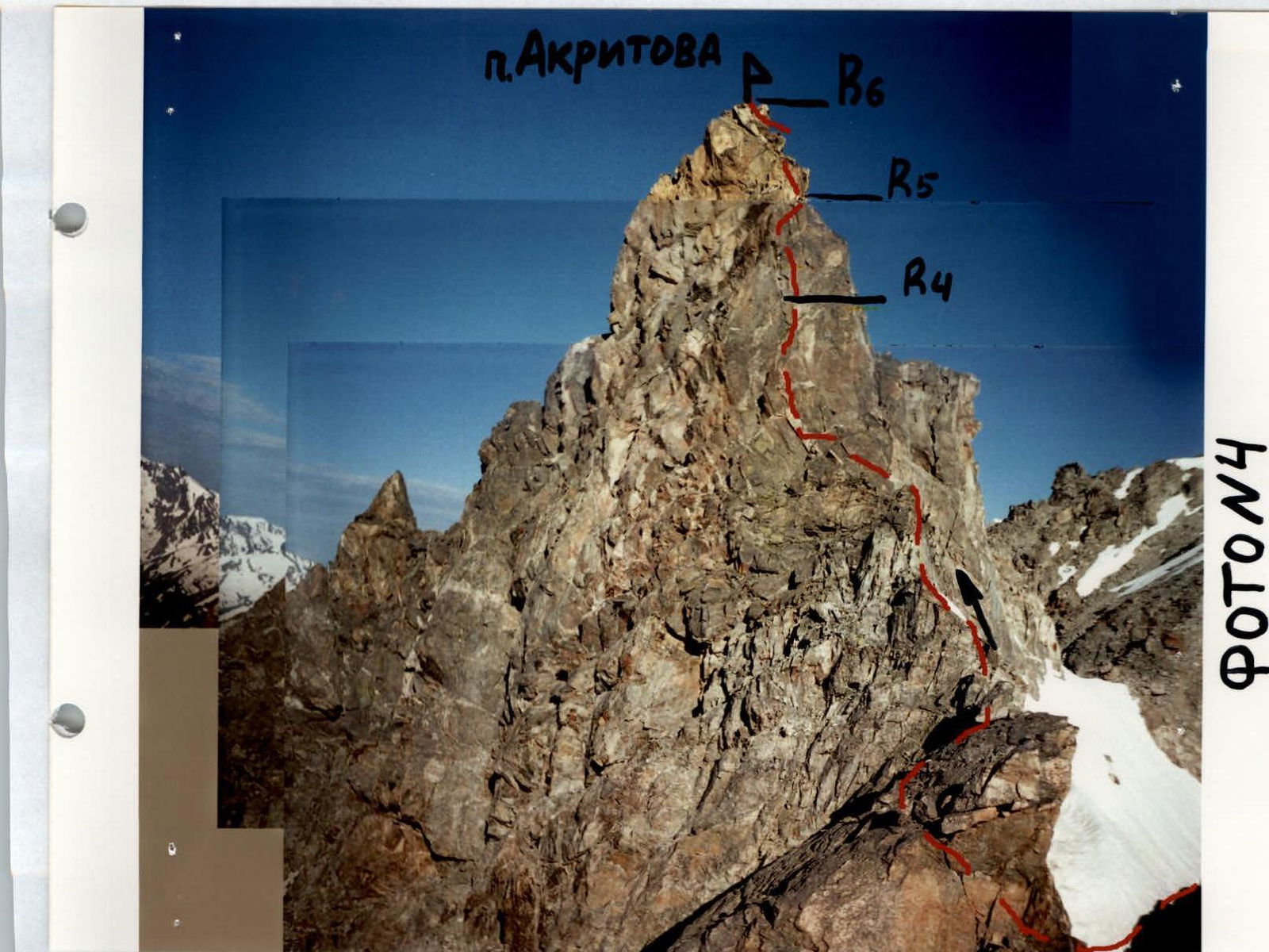
Eastern wall of peak Akritov
Photo # 4
 Start of E. wall of peak Akritov (sect. R3–R4), photo # 4a
 Passage of the upper part of the chimney E. wall of p. Akritov (sect. R4–R5), photo # 4b
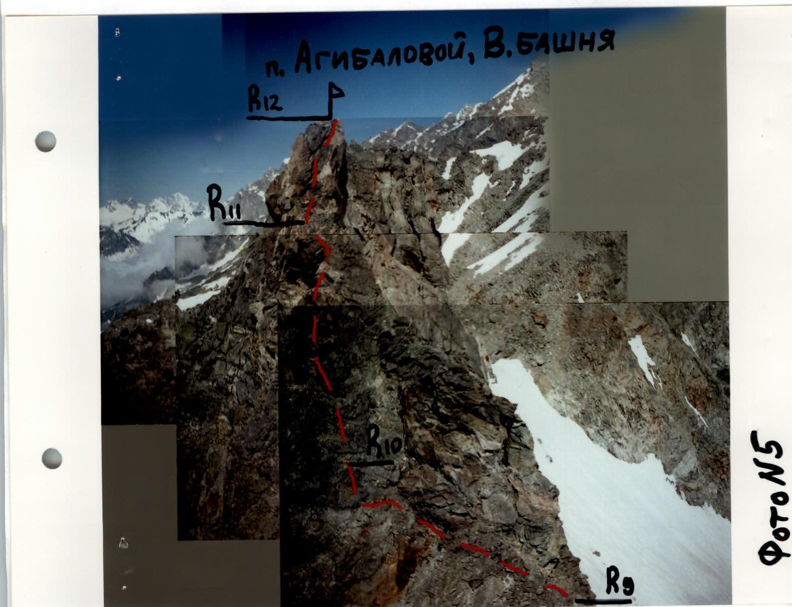 E. wall of E. tower of peak Agibalova, photo # 5
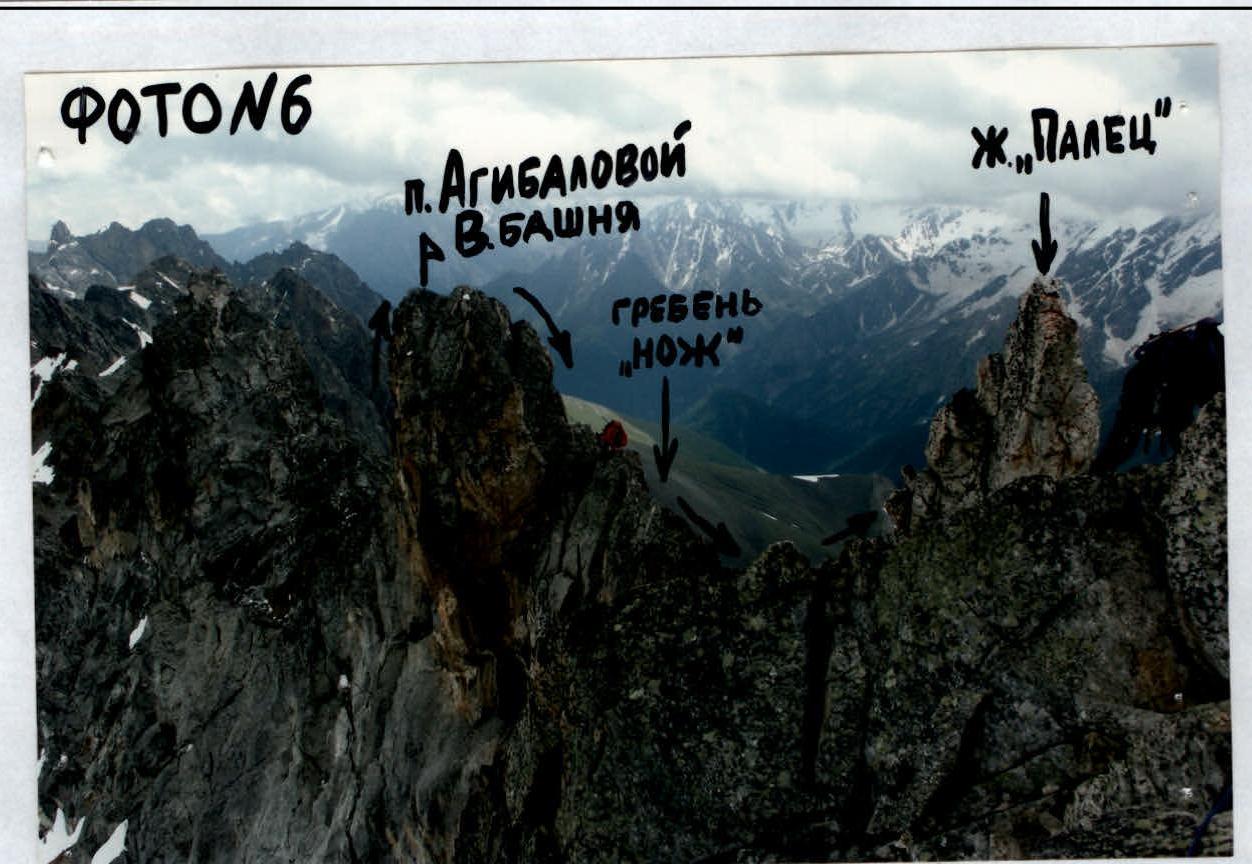 "Knife" between E. and W. towers of peak Agibalova (view from the north), photo # 6
Passage of ridge — "knife" (sect. R13–R14)
Photo # 6a
 E. wall of W. tower of peak Agibalova, photo # 7
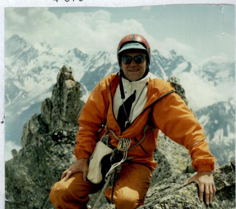 On W. tower of peak Agibalova.
Behind — gendarme "Finger", photo # 7a
On W. tower of peak Agibalova.
Behind — gendarme "Finger", photo # 7a
Route safety assessment
The route is laid along fairly monolithic rocks, the probability of spontaneous rockfall on which is minimal. The route is characterized by high steepness, technicality. On the walls there are small platforms for organizing intermediate stations.
On the key sections of the walls of p. Akritov and p. Agibalova (sections R3–R5, R10–R12) it is necessary:
- to exclude work of climbers under each other in order to avoid dropping stones.
Recommendations for passing the route:
- pass in dry weather;
- groups of no more than 5–6 people;
- the route can be recommended for passage by groups of athletes with good rock training.
Instructor: Strebejev V.N. (48. # 494)
Repeated passage of the route — traversing p. Akritov — p. Agibalova from E., Caucasus, Sugansky ridge
A repeated passage of the route was made to assess compliance with the stated 3B cat. diff.
Team composition:
- Strebejev V.N. — 1st sports category, instructor 2nd category;
- Simakhin R.V. — 2nd sports category;
- Dobrinskaya O.N. — 2nd sports category;
- Ved O.V. — 3rd sports category;
- Gribalko A.V. — 3rd sports category;
- Dubova E.S. — 3rd sports category;
- Rakhmilevich D.R. — 3rd sports category;
- Saranchuk A.I. — 3rd sports category.
Exit to the route from campsite July 21, 2003, on the same day passage of the traverse route and return. Team's walking hours from campsite — 10 h, descent via W. ridge of p. Agibalova — 2.5 h. One overnight stay at the Botkin campsite. The total length of the route, length and steepness by sections correspond to the stated, the route passes logically, there are necessary landmarks, cat. diff. corresponds to the stated.
Leader: Strebejev V.N. (48. # 1494)