Ascent Passport
- Ascent class — technical
- Ascent area — Central Caucasus, Bezengi
- Peak — Shaurtu Glavnaya via the right edge of the South ridge wall
- Difficulty category — 4A
- Route characteristics: height difference from Bezengi alpine camp is 2150 m average steepness 60° length of 4th difficulty sections — 30 m, 80 m, 90 m
- Pitons hammered: 13 rock, 2 ice, 6 chocks
- Time to summit — 10 hours
- Overnight under the route
- Full name of the leader, participants, and their qualification Doroshevsky Yu.L., leader, 2nd sports category Saratov Yu.S. — Master of Sports Tibeykin L.A. — Master of Sports Nazarov O.V. — Master of Sports
- Departure on August 2, 1982, return on August 2, 1982
Team coach Saratov Yu.S.
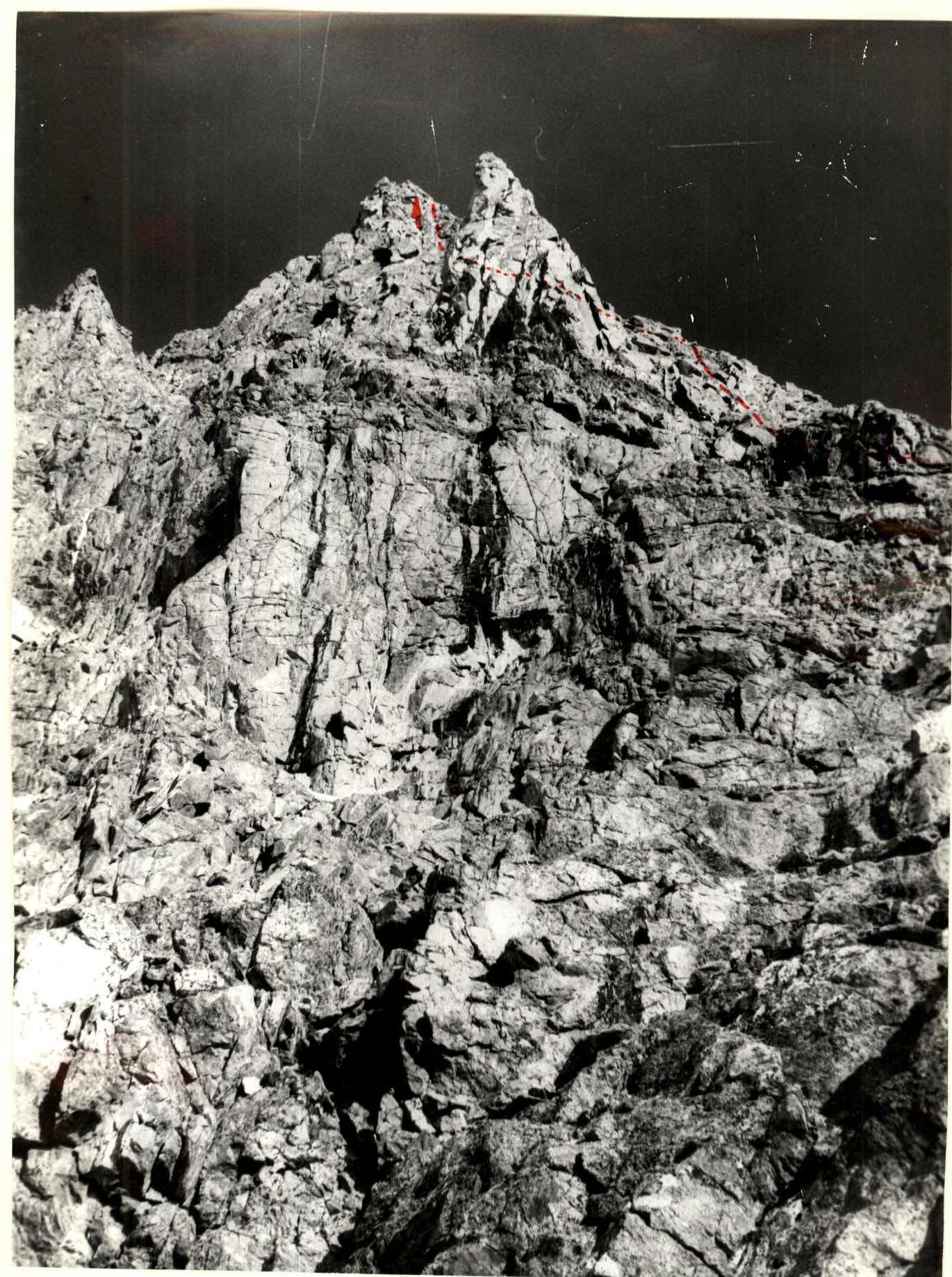
View of the central part of the South ridge wall at the beginning of the route
Preliminary route description
Ascent to Shaurtu Glavnaya peak via the right edge of the Southeast ridge wall. Shaurtu Glavnaya peak (4350 m) is the highest point of the Shaurtu massif, located in the southern part of the Kargashilsky ridge between Salynan peak to the southwest and Tyutyurgu peak to the northeast.
The route has the following advantages:
- It is safe from avalanches and rockfalls, as the snow on the northeastern slope should slide down into the couloir to the right of the route, and there are virtually no couloirs on the wall and few loose rocks.
- Most of the ascent to the summit is on rock, but there are sections requiring skills for walking on snow and ice and organizing protection with an ice axe and ice screws.
- The rocks of the right edge of the wall are monolithic, with many good holds and protection points.
- The route has many ledges suitable for rest and bivouacs in case of forced overnight stays.
- In the upper cirque of the Salynan glacier, there are both classified and unclassified routes from 2nd to 5th difficulty category. Thus, it is possible for multiple groups to ascend simultaneously.
- The descent from the summit is quite simple — via a classified 2B difficulty route down a wide snowy couloir.
- Shaurtu Glavnaya peak is located in a part of the Kargashilsky ridge from which, in clear weather, one can see the panorama of the Chegem valley (and to the west of it), the Bezengi wall, and the Bezengi valley to the east with routes to Misses-tau, Dykh-tau, and Simonovsky peak. Direct radio communication is possible with all these areas, as well as with the peaks in the Maly Uko valley.
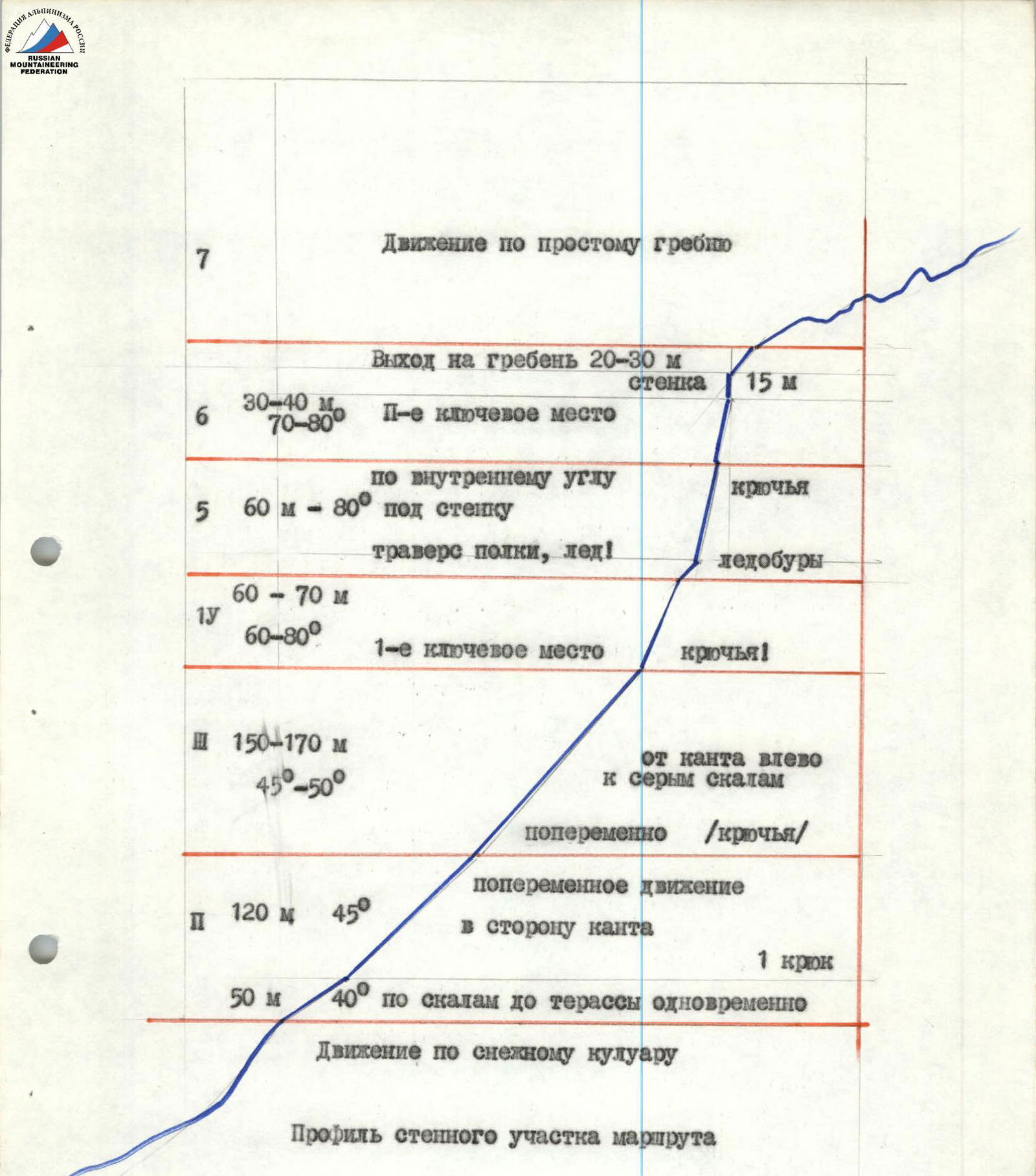
Profile of the wall section of the route
- Movement along a snowy couloir
- 50 m 40° on rocks to a terrace simultaneously
- II. 120 m 45° alternating movement towards the edge
- 1 piton
- III. 150–170 m 45°–50° from the edge left to grey rocks
- alternately (pitons)
- IV. 60–70 m 60–80° 1st key point
- pitons!
-
- 60 m – 80° along an internal corner under the wall
- traverse of a ledge, ice!
- ice screws
-
- 30–40 m 70–80° II-nd key point
- Exit to the ridge 20–30 m
- wall 15 m
-
- Movement along a simple ridge
Recommendations for climbers
- Overnight stay under the route.
- Rock pitons 3–4 mm, channel type — 8–10.
- Ice screws — 3–4 pieces.
- Descending loops and "sliders" — 4–5 pieces.
Possible mistakes:
- Transition from the couloir to the gully between the slopes and ascent along it.
- Exiting "too far to the right" onto the ledges and slabs of the northeastern slope of the Southeast ridge.
- Descending too low along the first couloir leading to Chegem instead of the Salynan glacier cirque (descent below the "gates" in the Salynan-Shaurti ridge).
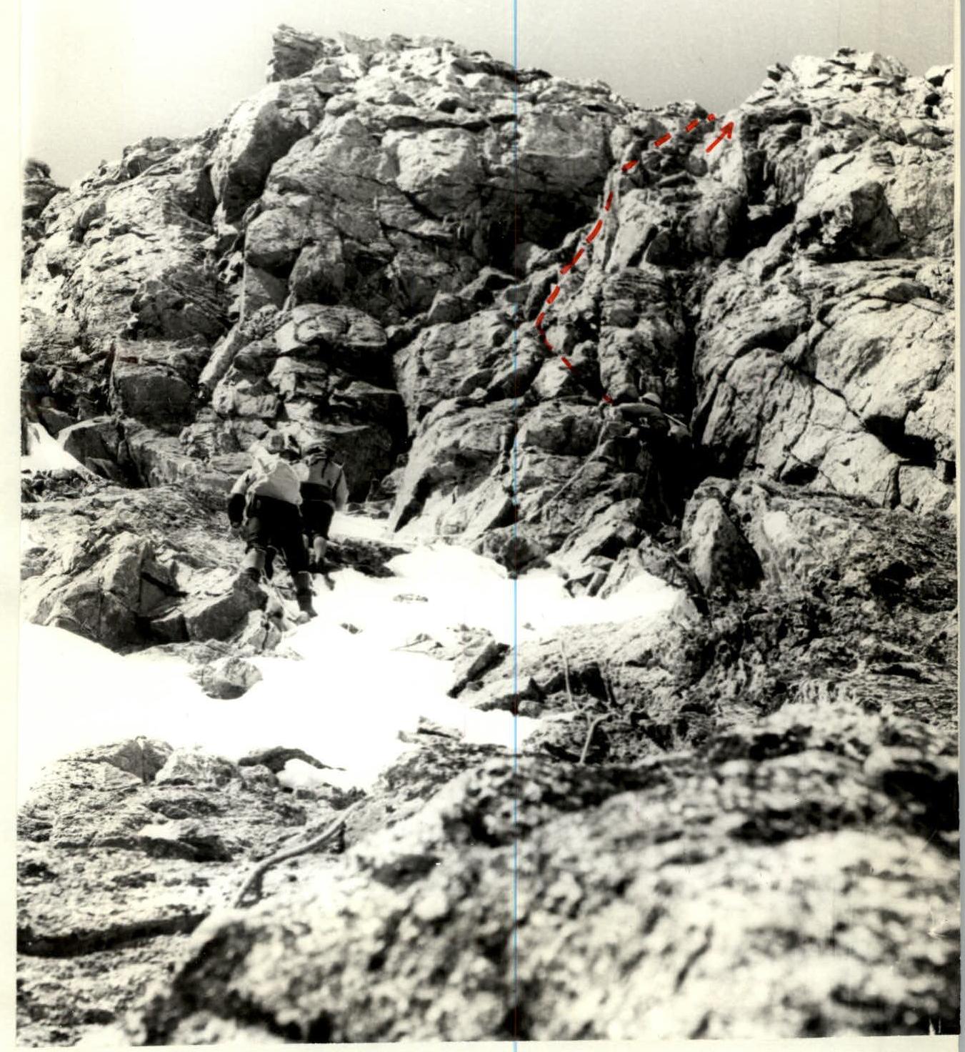
Path from the upper oblique ledge to the second key point
Appendix photo № 3
