Central Council of DSO "Avangard"
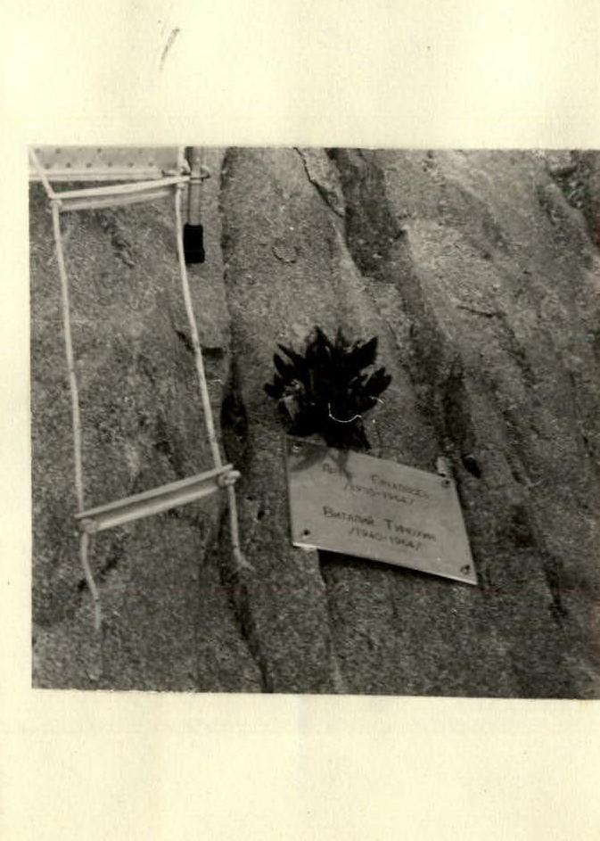
To the blessed memory of Ukrainian climbers Artur Glukhontsev and Vitaly Timokhin
we dedicate
Ascent to South Ushba via the Central part of the West wall
(report on the ascent)
V. Monogarov
Kiev—1965
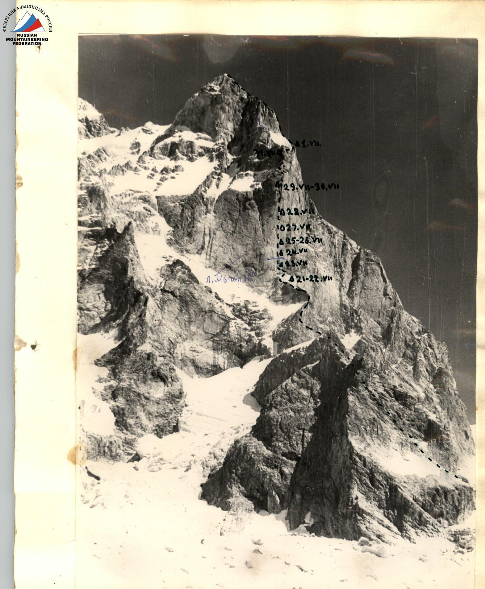
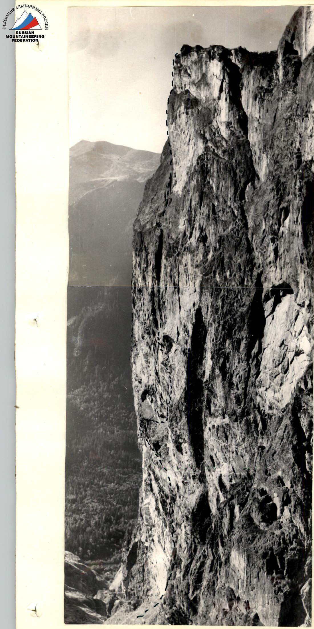
The route via the Central part of the West wall of South Ushba, traversed by the combined team of CS DSO "Avangard" in July 1965.
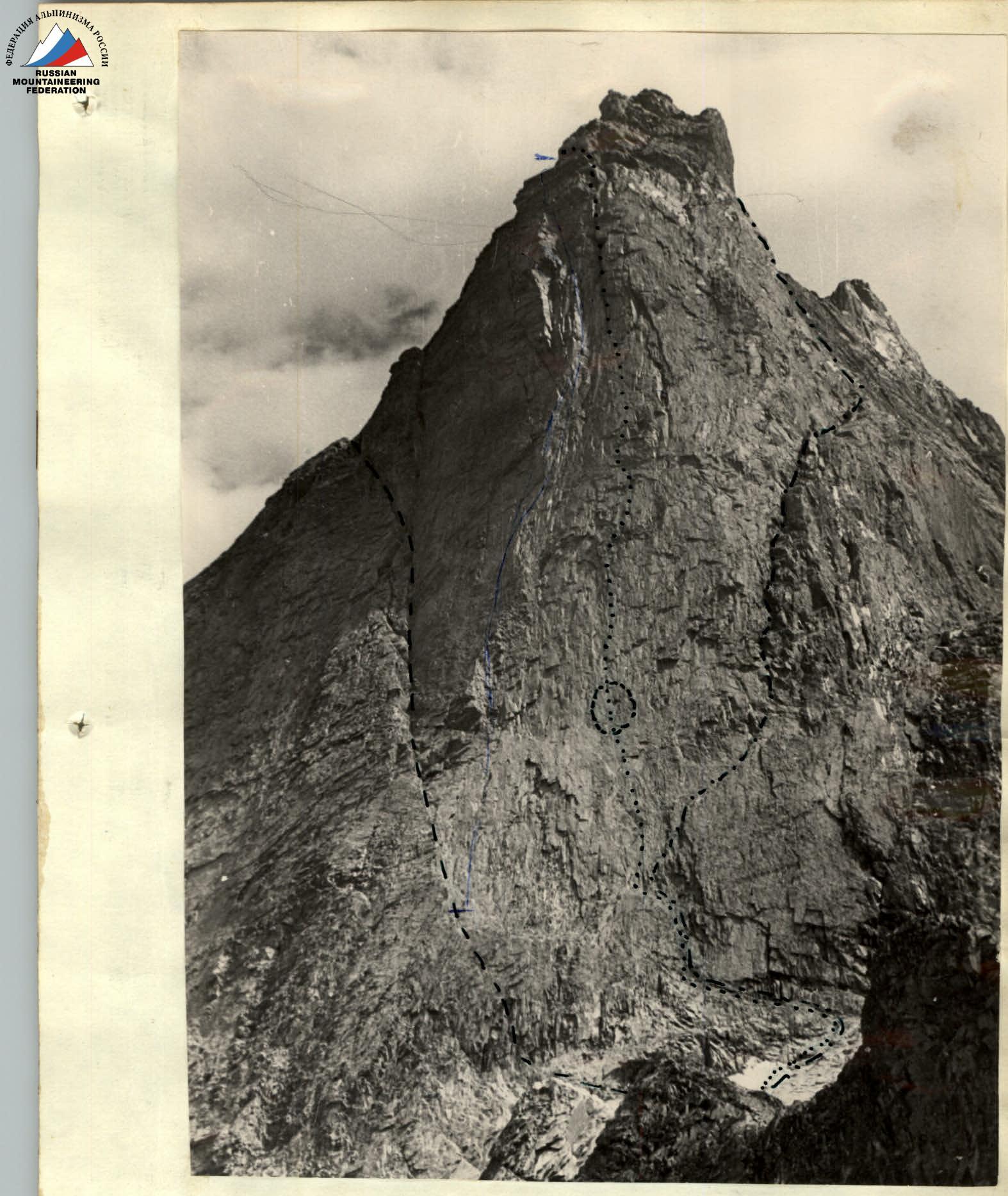
West wall of South Ushba. The upper part of the wall is not visible.
- Route of L. Myslyaev's group, 1960
- Route of A. Kustovsky's group, 1963
- Route of our team, 1965 (in the circle—backpacks of A. Glukhontsev and V. Timokhin)
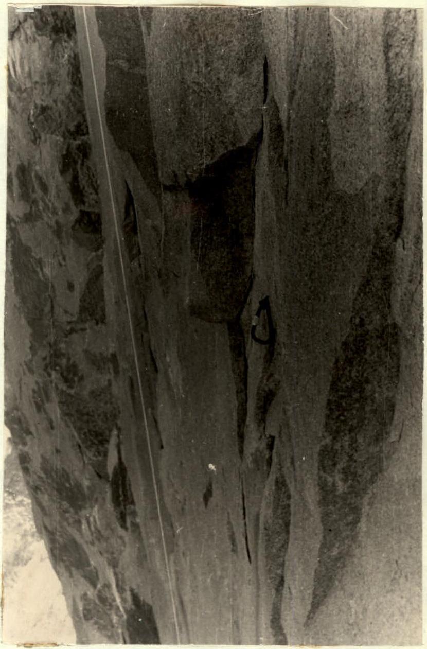
Beginning of the West wall. The final point reached by B. Romanov's group in 1962 (in circles—a carabiner and a wedge of B. Romanov's group).
| Surname, name, patronymic | sports rank | year of birth | party membership | nationality | sports experience | main profession | place of residence |
|---|---|---|---|---|---|---|---|
| MONOGAROV Vladimir Dmitrievich | Master of Sports | 1926 | CPSU member | Ukrainian | 1946 | lecturer | Kiev-111, Saratovskaya 10-a, apt. 36 |
| MASHCHENKO Nikolai Mikhailovich | Master of Sports | 1935 | non-party | Ukrainian | 1954 | electrician | Kiev, Grekova str., h. 13, apt. 1 |
| ALEKSYUK Mikhail Mironovich | Master of Sports | 1932 | non-party | Russian | 1952 | engineer | Kiev-58, Zheleznodorozhnaya 2/4, apt. 1 |
| KOVTUN Vladimir Kirillovich | Master of Sports | 1935 | non-party | Ukrainian | 1953 | turner | Kiev-125, Perova Blvd. p-5, apt. 73 |
| LAVRINENKO Dmitry Ivanovich | 1st sports rank | 1933 | CPSU member | Ukrainian | 1953 | lecturer | Kiev-125, Perova Blvd. h. 1/8, apt. 51 |
| GONCHAROV Vladlen Konstantinovich | 1st sports rank | 1938 | non-party | Russian | 1956 | lecturer | Simferopol, Gogol str. 54/15, apt. 11 |
X. Final data on the wall assault
The entire route to South Ushba via the West wall had an altitude difference of 1525 m and consisted of:
- lower, relatively easy part,
- middle, steep part,
- upper part of medium difficulty.
The route traversed by the team is of great technical complexity, very interesting in sporting terms, logical and beautiful.
The route via the Central part of the West wall of South Ushba, with a length of 605 m, was traversed in 7 days (78 h 50 min).
A lot of time was spent on pulling up backpacks, as it was complicated by a large number of:
- cornices
- overhanging sections.
Pitons and ropes left by A. Glukhontsev's group were not used due to their unreliability.
Sections of the wall with holds were traversed by free climbing. Thus, sections were traversed:
- R6–R7
- R13–R14
- R18–R19
- R20–R21
- R21–R22
- R22–R23
The total length of these sections was 270 m, i.e., almost half of the route. The rest of the wall could not be traversed by free climbing due to its steepness and complete lack of holds.
The entire route via the Central part of the West wall was extremely technically complex. The route could only be traversed with technique and experience in free climbing on steep cliffs, as well as the ability to use the entire arsenal of high-level rock climbing techniques.
A particular difficulty during the wall traversal was the section R16–R17 before the chimney. In this section, it was necessary to traverse huge slabs detached from the wall (roches moutonnées). It was not possible to bypass these slabs. On the route via the Central part of the West wall, more than 50 m were traversed on overhanging cliffs with a steepness of 95–100°, 300 m on cliffs with a steepness of 90°, and 200 m with a steepness of 80°.
On average, 70–100 m were traversed per day. One day was spent on approaching the backpacks of the deceased, photographing the site of the fall, and lowering the backpacks to the observation group (the backpacks were hanging off our route).
The observation group, located at the foot of the West wall and consisting of climbers of the 1st sports rank O. Grippa and V. Gumenyuk, was tasked with:
- transporting the backpacks of the deceased to our base camp.
The route was complicated by bad weather. On July 26, snow fell in the second half of the day, and on July 29, a snowstorm raged, heavily snowing up the cliffs, and avalanches descended along the wall. On July 30, we were forced to wait a whole day for the upper part of the wall to clear of ice and avalanches.
In bad weather conditions, the following provided invaluable assistance:
- cloak-tent
- "Pamirka" tent, which we took to the wall.
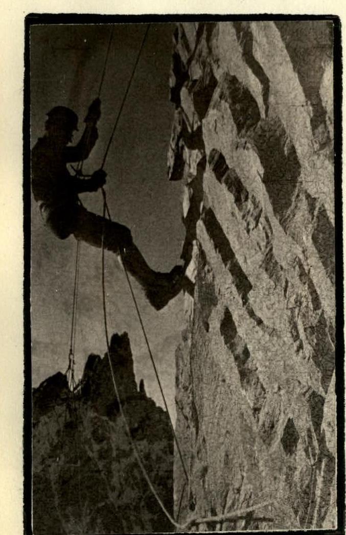
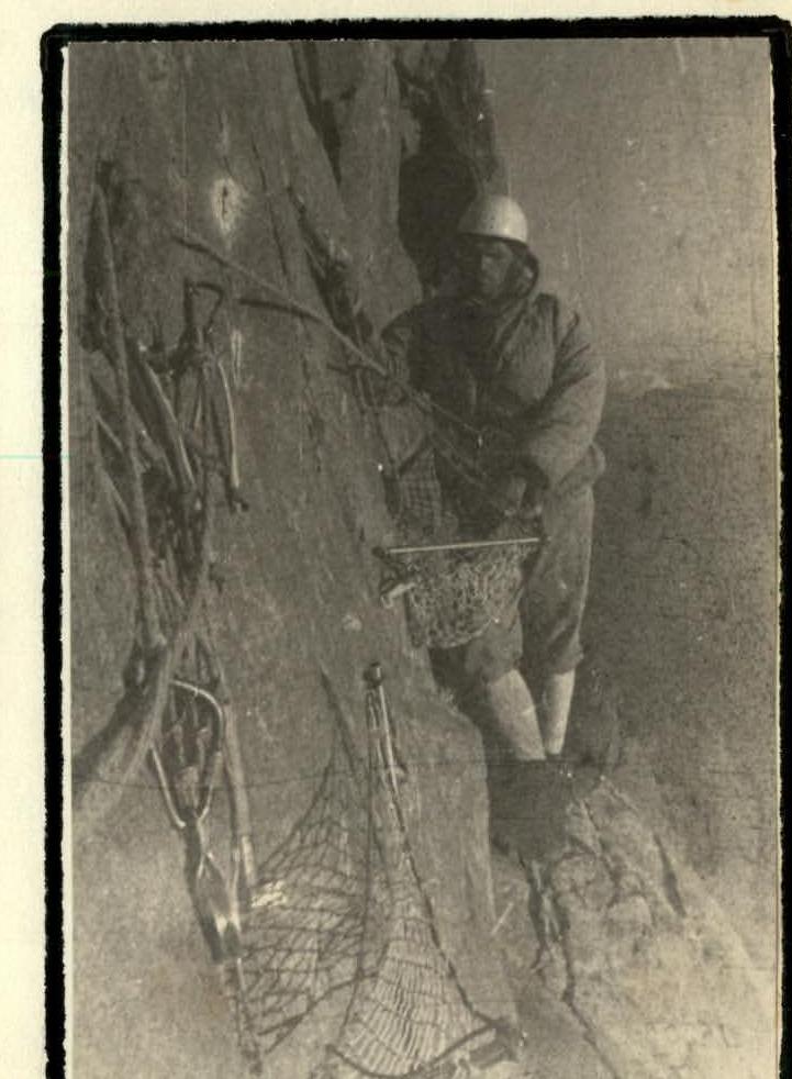
On the wall, we spent:
- 4 nights in hammocks (see photo)
- 2 nights sitting
- 2 nights in the upper part of the wall, lying on a small ledge, wrapped in tents (see photo).
It should be noted that the relatively comfortable position for rest and sleep while sitting in a platform with back support against a hammock, which was attached to a piton hammered at chest level. Such an organization of overnight stay requires minimal time and effort, as usually used pitons are hammered.
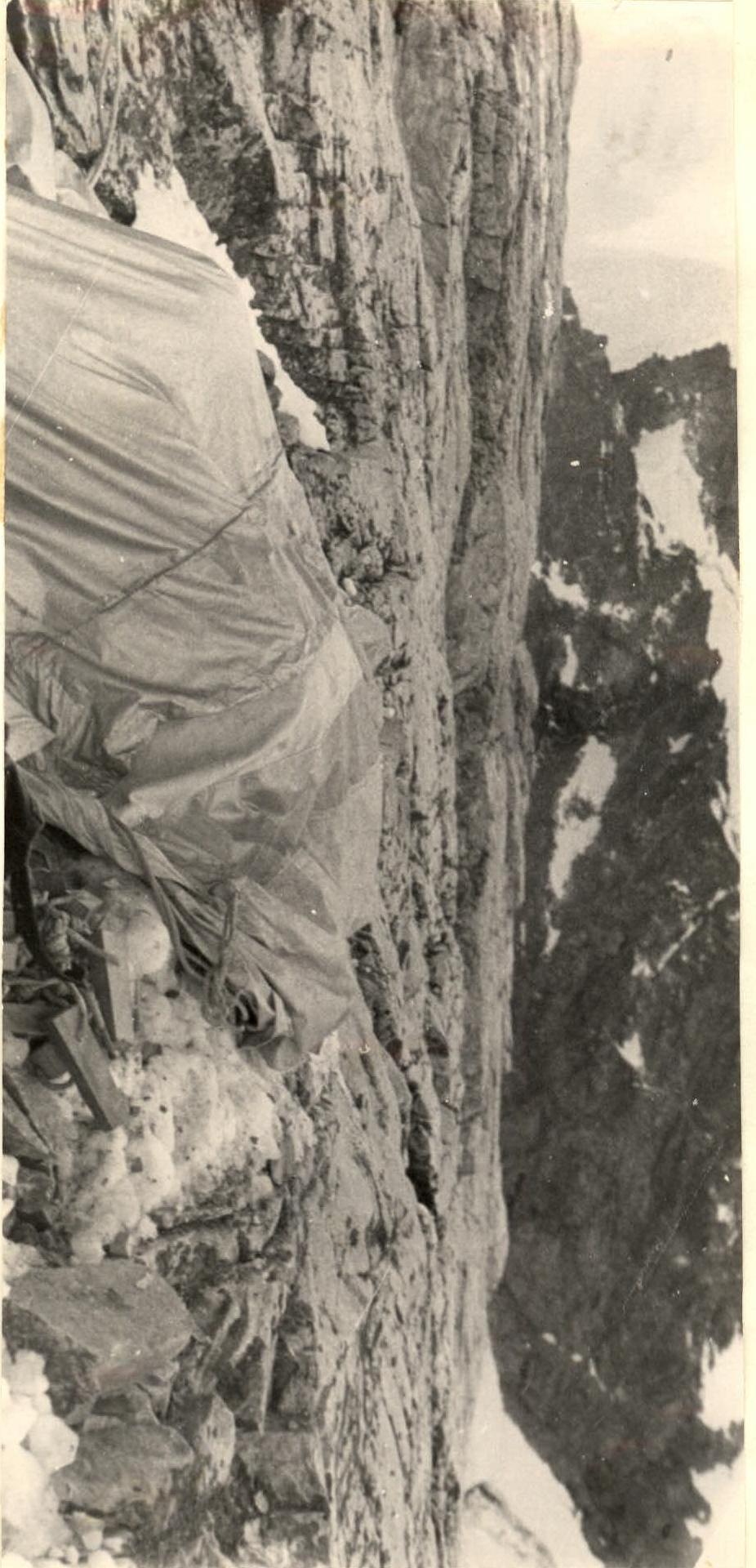
Overnight stay on a ledge "lying down" in the upper part of the wall on July 29 and 30, 1965. To make the route more convenient for future ascents, it is necessary to:
- improve existing platforms.
Among the rock climbing equipment, the most successful were drill pitons, which, when properly hammered, can withstand loads of up to 1600 kg on shear and 800 kg on pull-out.
The team considers it a pleasant duty to thank Kiev climbers, Masters of Sports, engineers V. Yakovina and A. Kustovsky for improving and thoroughly researching drill pitons and drills.
The team also believes that on rocks with small cracks, where it is impossible to hammer a rock piton of standard design for effective belaying, drill pitons should be used.
Any pitons of reduced non-standard sizes (petal or shortened) are unreliable for belaying, and their use can lead to accidents, as it was with A. Glukhontsev and V. Timokhin.
Our team established that the cause of V. Timokhin's fall was the detachment of the eyelet welded to the petal titanium horizontal piton. The weld was torn during the hammering of the piton into the crack and did not withstand V. Timokhin's body weight. A. Glukhontsev's further fall could not be arrested by shortened pitons, which were pulled out.
The cause of A. Glukhontsev's and V. Timokhin's deaths was, first and foremost, incorrect tactics when moving along steep cliffs. The lead climber moved away from the belayer by 40 m on a single rope. To facilitate rope pull-through multiple carabiners, he did not thread the rope through all carabiners.
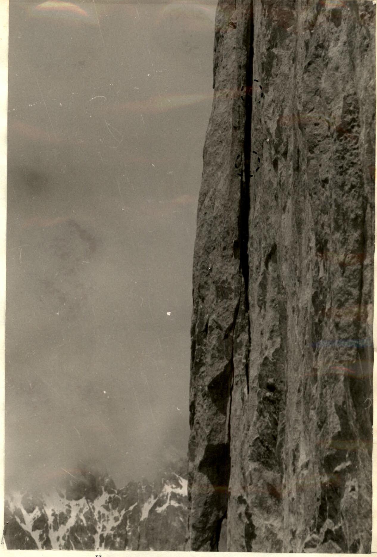
Unused carabiner of Artur Glukhontsev's group


Carabiners of Artur Glukhontsev's group. We found 12 undetached and undeformed drill pitons, on which there were no signs of remaining rope carabiners. We also found 4 well-hammered rock pitons of standard design with steel carabiners attached (see photo).
It should be noted that the pace of our team's movement along the wall was optimal compared to the pace of movement during the first ascent of a similar wall on the west. For example, the first ascent of "Devil's Needles" via the Red steep wall, 300 m long, took 6 days for the first ascenders. The team consisted of 5 people led by the Honored Master of Sports of Bulgaria, international-class climber G. Atanasov.
When traversing this wall in September of this year, we established that the route is traversed by climbing only one-third of the route, while the rest of the wall is traversed only with the use of artificial holds organized with the help of:
- drill pitons,
- regular pitons,
- wooden wedges.
(see diagram in the appendix)
Subsequent groups after the first ascenders ascended this wall in 8–10 hours along the pitons hammered by the first ascenders. Our foursome consisting of:
- V. Monogarov
- N. Mashchenko
- V. Goncharov
- O. Grippa
traversed this route in 15 hours.
The ascent to South Ushba via the Central part of the West wall is the most complex of all wall ascents performed by the combined team of CS DSO "Avangard" in previous years, both in the USSR and abroad.
Comparing the route to South Ushba via the Central part of the West wall with routes of the 6th category of difficulty traversed by us in Yugoslavia ("Triglav"—"Chopov pillar" 6th category, 1963), in Austria ("Dachstein", direct route 6th category and "Gizoyze"—5th category, 1964), in Bulgaria ("Devil's Needles" via the Red wall 6B category, 1965) (see photo), the team believes that the traversed route to South Ushba is undoubtedly a route of the highest, sixth category of difficulty.
It should be noted that the main criterion for evaluating a route as extremely difficult and determining its belonging to the highest category (e.g., 6th category) abroad, in Yugoslavia, Austria, and Bulgaria, is its:
- steepness
- traversal of steep sections and cornices
- use of artificial holds
Routes of the 6th category abroad are mostly not traversed by climbing. Even steep routes traversed by free climbing are classified as 5th category.
The team dedicated their ascent to the blessed memory of our good friends Artur Glukhontsev and Vitaly Timokhin.
On behalf of the team, Team leader and trainer, Master of Sports of the USSR V. Monogarov
The report was compiled by Master of Sports M. Aleksyuk and D. Lavrenko.
Route to "Devil's Needles" via the Red wall 6B category, traversed by members of our team in Bulgaria in 1965.
The 300 m long route was traversed by the first ascenders in 1961 in 6 days.
Vitaly Timokhin
(1940–1964)
Photographs taken from the film found in A. Glukhontsev's backpack.
Artur Glukhontsev (1935–1964)
TABLE
Main characteristics of the ascent route via the Central part of the West wall of South Ushba traversed by the team of CS DSO "Avangard"
Overhanging steepness 95–100° – 50 m.
Altitude difference of the West wall — 605 m. Total ascent route — 1525 m. Including the most complex sections — 545 m. Steepness of the route via the Central part of the West wall — 80–90°. Including the most complex sections: 90° — 295 m, 80° — 200 m.


| Date | Traversed sections | Average steepness of sections (in degrees) | Height of sections (in meters) | Terrain characteristics | Technical difficulty | Method of traversal and belaying | Weather conditions | Departure time | End time | Working hours | Rock and wedge pitons | Ice pitons | Drill pitons | Overnight stay and daily ration weight |
|---|---|---|---|---|---|---|---|---|---|---|---|---|---|---|
| Approach to the base of the West wall | ||||||||||||||
| July 21 | R0–R1 | 40 | 80 | Shallow snow with rock outcrops. | Easy | Simultaneous movement | Clear | 7 am | — | 30 min | — | — | — | 800 g |
| — | R1–R2 | — | 200 | Traverse of a rocky ridge. Rocks are fragmented. | Easy | — | — | — | — | 3 h 30 min | — | — | — | — |
| — | R2–R3 | 70 | 20 | Solid rocks. Ascent to the left upwards. | Medium difficulty | Climbing with pitons | Cloudy | — | — | 1 h 40 min | 2 | — | — | — |
| — | R3–R4 | 60 | 60 | Fragmented rocks. | — | — | — | — | — | 1 h 30 min | 2 | — | — | — |
| — | R4–R5 | 70 | 40 | Solid rocks. Ascent to the left of the ridge upwards. | — | — | — | 4 pm | 6:30 pm | 20 min | 4 | — | — | — |
| — | 200 | 84 h 40 min | 8 | |||||||||||
| Transporting cargo to the wall from the ridge bivouac | ||||||||||||||
| July 22 | R5–R6 | 60 | 80 | Fragmented rocks, then slabs. | Medium difficulty | Climbing with pitons | Cloudy | 8 am | — | 3 h | 3 | — | — | On a site |
| — | — | — | — | Descent to the bivouac on the ridge, filling water reservoirs, clarifying the ascent route. | — | — | — | — | — | — | — | — | — | On a site, 800 g |
| — | — | — | 280 | 11 h 40 min | 11 | |||||||||
| INSTALLATION OF A MEMORIAL PLAQUE. FIRST DAY OF ASCENT UP THE WALL | ||||||||||||||
| July 23 | R6–R7 | 40 | 40 | Ascent to the left-right upwards along solid rocks, then traverse to the left along a steep inclined ledge. | Difficult | Climbing with pitons | Partly cloudy | 7 am | — | 1 h 30 min | 6 | — | — | 800 g |
| — | R7–R8 | 80 | 20 | Smooth rocks with few holds. | Very difficult | — | — | — | — | 2 h | 6 | — | — | — |
| — | — | — | — | Installation of a memorial plaque on the wall above the ledge. Pulling up backpacks. | — | — | — | — | — | — | — | — | — | — |
| — | R8–R9 | 80 | 20 | Smooth monolithic rocks with few cracks. Exit to a ledge. Pulling up backpacks. | — | Climbing using artificial holds | — | — | — | 3 h | 3 | — | 12 | — |
| Route processing | ||||||||||||||
| July 23 | R9–R10 | 85–90 | 20 | Smooth monolithic rocks with a meter-long cornice at the top. Bypassing the cornice to the left along a three-meter overhang. | Very difficult | — | — | — | — | 4 h 30 min | 7 | — | 12 | In hammocks |
| Total: | 100 | 10 h 30 min | 22 | 24 | ||||||||||
| SECOND DAY OF ASCENT UP THE WALL | ||||||||||||||
| July 24 | R10–R11 | — | — | Traversing section R9–R10 | — | — | — | 7 am | — | 1 h 30 min | — | — | — | 800 g |
| — | R10–R12 | 85–90 | 40 | Smooth monolithic rocks. Bypassing a cornice to the left, traversing two cornices along six-meter overhangs. Very difficult pulling up backpacks, hindered by cornices. | — | — | Sleet, snow | — | — | 6 h | 15 | — | 20 | — |
| Route processing | ||||||||||||||
| — | R12–R13 | 90 | 30 | Smooth monolithic rocks with few cracks. Rocks are partly overhanging. | — | — | Cloudy | 6:30 pm | — | 4 h | 11 | — | 16 | In hammocks |
| Total for the day: | ||||||||||||||
| — | 70 | 11 h 30 min | 26 | 36 | ||||||||||
| THIRD DAY OF ASCENT UP THE WALL | ||||||||||||||
| July 25 | R11–R12 | — | — | Traversing section R11–R12 | — | — | — | — | — | 2 h | — | — | — | 800 g |
| — | R12–R13 | 90 | 20 | Monolithic rocks with few cracks. | — | Free climbing with pitons | Cloudy | 8 am | — | 3 h | 8 | — | 10 | In hammocks |
| — | R13–R14 | 80 | 15 | Inner corner. Slightly fragmented rocks. Exit to an inclined ledge. | — | — | — | — | — | 1 h 30 min | 7 | — | 2 | — |
| Route processing | ||||||||||||||
| — | R14–R15 | 90 | 20 | Monolithic rocks. Bypassing a cornice along a three-meter overhang. Photographing the site of Timokhin's and Glukhontsev's fall. Pulling up backpacks. | — | Climbing using artificial holds | — | 5:30 pm | — | 3 h | 10 | — | 7 | In hammocks |
| Total for the day: | ||||||||||||||
| — | 55 | 9 h 30 min | 25 | 10 |
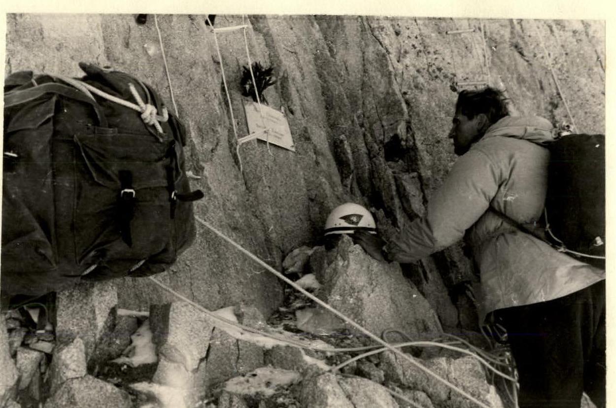
We installed a memorial plaque in memory of our friends at the foot of the West wall.
- Descent 30 m to Glukhontsev's and Timokhin's backpacks.
- Repacking backpacks, pulling them up to the ledge, and lowering them from the ledge to the observation group.
- Replenishing water supplies, for which we traversed the wall to the right.
| Date | Traversed sections | Average steepness of sections (in degrees) | Height of sections (in meters) | Terrain characteristics | Technical difficulty | Method of traversal and belaying | Weather conditions | Departure time | End time | Working hours | Rock and wedge pitons | Ice pitons | Drill pitons | Overnight stay and daily ration weight |
|---|---|---|---|---|---|---|---|---|---|---|---|---|---|---|
| FOURTH DAY OF ASCENT UP THE WALL | ||||||||||||||
| July 26 | — | — | — | Descent 30 m to Glukhontsev's and Timokhin's backpacks. Repacking backpacks, pulling them up to the ledge, and lowering them from the ledge to the observation group. Replenishing water supplies, for which we traversed the wall to the right. | Very difficult | Climbing using artificial holds | Cloudy. Sleet and snow in the second half. | 8 am | 5 pm | 1 h 30 min | — | — | — | On the wall in hammocks, 800 g |
| July 27 | R14–R15 | 90 | 40 | Monolithic rocks with few cracks. Pulling up backpacks. | — | — | — | 7 am | 30 min | 4 h | 22 | — | 14 | — |
| — | R16–R18 | 90 | 25 | Detached slabs. Bypassing a cornice along a two-meter overhang. Ascent upwards-right towards the base of the chimney. Pulling up backpacks. | — | — | — | — | — | 3 h | 8 | — | 14 | — |
| Route processing | ||||||||||||||
| — | R18–R19 | 90 | 45 | Narrow chimney with monolithic walls. | — | Free climbing with pitons | — | 6 pm | — | 3 h 20 min | — | — | 9 | Sitting on platforms |
| Total for the day: | ||||||||||||||
| — | 110 | 11 h 50 min | 30 | 37 | ||||||||||
| FIFTH DAY OF ASCENT UP THE WALL | ||||||||||||||
| July 28 | R18–R19 | — | — | Traversing section R18–R19 | — | — | Cloudy | 7 am | — | 2 h | — | — | — | 800 g |
| — | R18–R19 | 100 | 30 | Overhanging monolithic rocks. Pulling up backpacks. | — | Climbing using artificial holds | — | — | — | 5 h | 9 | — | 15 | — |
| — | R19–R20 | 90 | 45 | Traversing a three-meter overhang and bypassing a six-meter cornice from right-up-left along a wet smooth slab. Drilling holes with a drill was very difficult due to water cementing the hole. Pulling up backpacks was difficult on all sections. | Medium and high difficulty | Climbing using artificial holds | — | 7 pm | — | 5 h | 18 | — | 12 | Sitting on platforms |
| Total for the day: | ||||||||||||||
| — | 75 | 12 h | 27 | 27 | ||||||||||
| SIXTH DAY OF ASCENT UP THE WALL | ||||||||||||||
| July 29 | R20–R24 | 80 | 40 | Inner corner, rocks slightly fragmented and covered with snow and ice. Pulling up backpacks for 3 hours. | — | Free climbing with pitons | Snowfall | 9 am | 4 pm | 4 h | 15 | — | — | 800 g on a site lying down |
| Total for the day: | ||||||||||||||
| — | 40 | 4 h | 15 | 6 | ||||||||||
| July 30 | — | — | — | Forced rest day due to strong snowfall and avalanches on the route, rocks were heavily snowed. Movement along the route was hazardous. | — | — | Clear | — | — | — | — | — | — | 600 g on a site lying down |
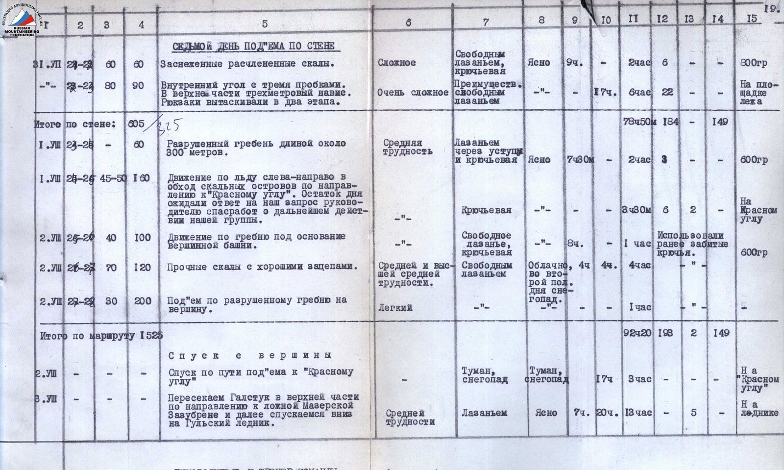
| SEVENTH DAY OF ASCENT UP THE WALL | ||||||||||||||
| July 31 | R24–R29 | 60 | 60 | Snow-covered fragmented rocks. | Complex | Free climbing with pitons | Clear | 9 am | — | 2 h | 6 | — | — | 300 g |
| — | R29–R24 | 80 | 90 | Inner corner with three corks. Three-meter overhang at the top. Pulling up backpacks in two stages. | Very complex | Mostly free climbing | — | 5 pm | 6 am | 13 h | — | — | — | On a site lying down |
| Total for the wall: | ||||||||||||||
| — | 605 | 78 h 50 min | 184 | 149 | ||||||||||
| Descent from the summit | ||||||||||||||
| August 1 | R23–R25 | — | 60 | Fragmented ridge about 300 m long. | Medium difficulty | Climbing through ledges and pitons | Clear | 7:30 am | — | 2 h | 3 | — | — | 600 g |
| August 1 | R25–R25 | 45–50 | 160 | Movement on ice to the left-right bypassing rocky islands towards the "Red corner". The rest of the day was spent waiting for a response from the rescue works leader regarding further action for our group. | — | Piton belaying | — | — | — | 3 h 30 min | 6 | 2 | — | On the "Red corner" |
| August 2 | R25–R29 | 40 | 100 | Movement along the ridge towards the base of the Summit Tower. | — | Free climbing with pitons | — | 8 am | — | 1 h | — | — | — | 600 g |
| August 2 | R26–R28 | 70 | 120 | Solid rocks with good holds. | Medium and high difficulty | Free climbing | Cloudy, snow in the second half of the day. | 4:44 am | 4 pm | 4 h | — | — | — | — |
| August 2 | R28–R29 | 30 | 200 | Ascent along the fragmented ridge to the summit. | Easy | — | — | — | — | 1 h | — | — | — | — |
| Total for the route: | ||||||||||||||
| — | 1525 | 92 h 20 min | 193 | 149 | ||||||||||
| Descent from the summit | ||||||||||||||
| August 2 | — | — | — | Descent along the ascent route to the "Red corner" | — | — | Fog, snowfall | 5 pm | — | 3 h | — | — | — | On the "Red corner" |
| August 3 | — | — | — | Crossing the "Gulstak" in the upper part towards the false Mazer notch and then descending down to the Gulsky glacier. | Medium difficulty | Climbing | Clear | 7 am | 8 pm | 13 h | — | — | 5 | On the glacier |
Team leader and trainer


Bypassing a cornice to the left, section R9–R10