Ascent Log
- Climbing grade — technically challenging.
- Ascent area — Main Caucasian Ridge and its spurs from Chipperaza Pass to Ortokara peak.
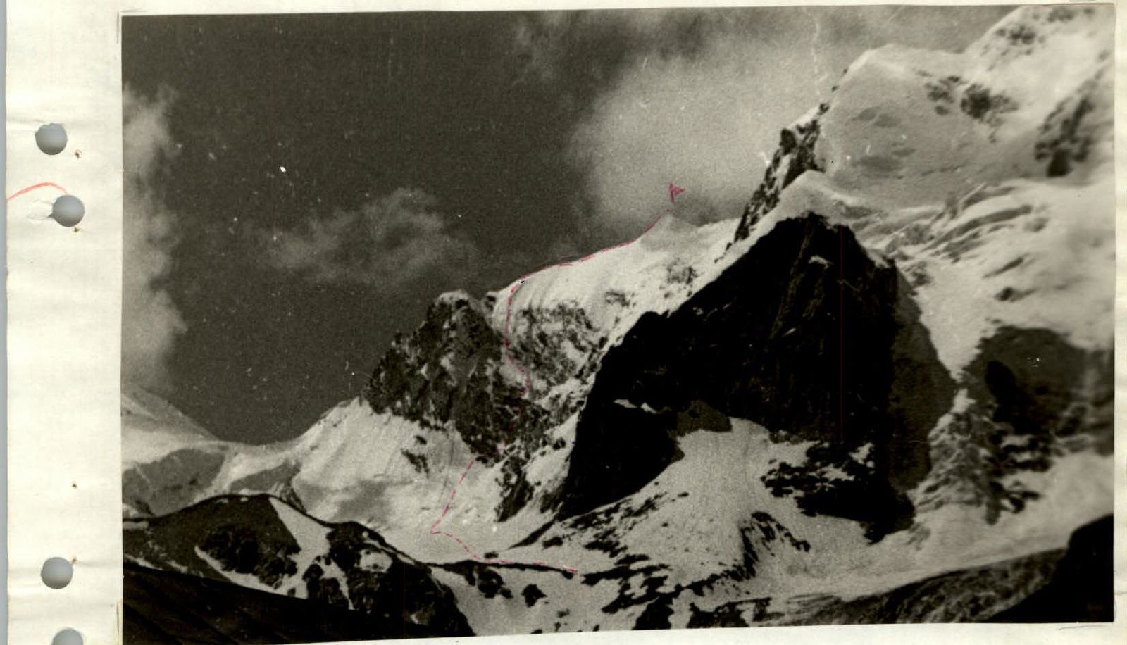
- Peak, its height, ascent route — Mt. Latsga (3999 m) eastern wall.
- Proposed difficulty category — 5A.
- Route characteristics: height difference — 620 m average steepness — 52° length of sections — 5th cat. diff. — 197 m
- Pitons hammered: for belay and for creating R.P.E. rock pitons 56 5; 2 wooden wedges ice screws 10 bolt pitons —
- Number of climbing hours — 25 hours
- Number of overnight stays, their characteristics — one, bivouac.
- Full name of the leader, participants, and their qualifications:
- Ortin A.A. — leader 1st sports category
- Sinakin G.I. — participant CMS (Candidate for Master of Sports)
- Chernyshev I.B. — participant 1st sports category
- Efimov R.P. — participant 1st sports category
- Team coach: Porokhnya O.I. — Master of Sports of the USSR
- Date of departure and return: Departure June 30, 1976 Return July 3, 1976
MAP-SCHEME of the ascent to Mt. Latsga 3999 m


Photo #1
Ascent Description
(explanation to the table, appendix 2)
June 30, 1976. The group left the "Ullutau" alpine camp at 17:00 and stopped at the "Cheget bivouac" at 18:30. (see description of the approach to the route). July 1, 1976. Departure from the bivouac at 6:00. We approached the start of the route via the glacier, which begins with a snow-ice slope with a steepness of 40–45° and a length of 180 m up to a group of rocks under the wall. The slope is cut by a bergschrund in its upper part. Alternating movement, belay through an ice axe. In the second half of summer, the bergschrund presents a serious obstacle. From the rocks, we moved right-upwards under the base of the wall — a snow-ice slope with a steepness of 45–50°, length 60 m. We reached the lower part of the wall and moved right-upwards along the ledges, traversing to a large inclined platform. Rocks of medium difficulty, steepness of the section 45°, length 60 m. 2 rock pitons were hammered. Upwards along the "ram's foreheads" type rocks with a steepness of 45–50° for 15 m to a small ledge. 1 control cairn. 1 rock piton was hammered. Live rocks on the ledges.
The ledge is located under the right edge of a trough-shaped depression in the black wall with overhanging blocks in its upper part. The wall is pierced by small icicles and is wet on the left and in the center.
The section of the route goes along the right edge. Dry and safe, steepness 70°, length 50 m.
Climbing is complex, and the use of ladders is necessary when exiting onto the inclined slab in the upper part. There is a good outcrop here through which belay can be organized.
15 rock pitons were hammered on this section.
Having processed this section, the group descended down to the bivouac at "Chegetskie nochi" by 17:00.
July 2, 1976. Departure from the bivouac at 4:00. We approached the wall along the beaten tracks. Here, along the hung ropes, the group ascended on jumars to the outcrop.
Further, right-upwards, along the inclined slab, then along the block-type rocks, we reached the base of the rusty wall. 40 m, 4 pitons were hammered.
The wall is cut by a powerful crack in the center, ending in a chimney with a cornice in its upper part. Steepness of the wall 80–85°, height 30 m. 12 rock pitons were hammered, 2 wooden wedges. The use of ladders is necessary. Immediately after the chimney, there is a good platform where an overnight stay can be arranged. The 2nd control cairn is installed here.
TABLE OF MAIN CHARACTERISTICS OF THE ASCENT ROUTE
| Date | Section | Steepness (°) | Length (m) | Terrain | Difficulty | Weather | Belay conditions | Rock pitons | Ice screws | Rock R.P.E. | Ice R.P.E. | Time, bivouacs, control cairns |
|---|---|---|---|---|---|---|---|---|---|---|---|---|
| June 30, 1976 | Stop for bivouac at 18:30 | |||||||||||
| Approach to "Chegetskie nochi" | ||||||||||||
| July 1, 1976 | Departure from bivouac at 6:00 | |||||||||||
| From "Chegetskie nochi" along the glacier to the start of the route | ||||||||||||
| R0–R1 | 45 | 240 | Snow-ice slope | 2–3 | Bergschrund | Good belay through ice axe | Free climbing | |||||
| R1–R2 | 45 | 60 | Ledges | 3 | Live rocks | 2 | ||||||
| R2–R3 | 45 | 15 | Ram's foreheads | 3 | Live rocks | 1 | 1 control cairn | |||||
| R3–R4 | 70 | 50 | Wall | 5 | Monolith | 14 | 1 | Stop for bivouac at 17:00. Climbing time 9 hours | ||||
| July 2, 1976 | Departure from bivouac at 4:00 | |||||||||||
| R4–R5 | 50 | 40 | Slab, block-type rocks | 4 | Monolith | 4 | ||||||
| R5–R6 | 80 | 30 | Wall | 5 | Monolith | 10 | 2 | 2 wooden wedges | 2 control cairns | |||
| R6–R7 | 90 | 7 | Wall | 5 | Monolith | 1 | 1 | |||||
| R7–R8 | 45 | 50 | Ridge | 4 | Live rocks | 6 | ||||||
| R8–R9 | 45 | 50 | Snow-ice ridge | 3 | 2 | 1 | ||||||
| R9–R10 | 50 | 40 | Rocks covered with snow and ice | 4 | 4 | 1 | ||||||
| R10–R11 | 55 | 50 | Snow-ice couloir | 4 | 6 | 2 | ||||||
| R11–R12 | 55 | 60 | Snow-ice couloir | 5 | 4 | 4 | ||||||
| R12–R13 | 60 | 50 | Snow-ice slope | 5 | Satisfactory | 2 | 2 | |||||
| R13–R14 | 45 | 180 | Snow-ice slope | 3 | Satisfactory belay through ice axe | Stop for bivouac at 20:00. Climbing time 16 hours | ||||||
| Bad | ||||||||||||
| July 3, 1976 | Departure from bivouac at 6:00. Ascent to the summit at 7:00. Descent to "Tarvash" pass via route 2A cat. diff. in low visibility. Return to "Ullutau" alpine camp at 12:00. |
From the platform, straight up along the smooth vertical wall (7 m), we exit onto the rock ridge.
We moved along the ridge to a small rock of bright rusty color, where there is a platform for belay. Steepness of the ridge 45°, from the 2nd cairn to the platform 60 m. 8 rock pitons were hammered.
From the rusty rock upwards, there is a snow-ice ridge with a steepness of 45° and a length of 50 m. It approaches the wall. 2 rock pitons and 1 ice screw were hammered.
Under the wall, along the rocks and ice, we traverse left-upwards to a weakly expressed snow-ice couloir with rock inclusions, leading to the pre-summit ridge. On 40 m, 4 rock pitons and 1 ice screw were hammered. Careful belay!!!
We moved along the right part of the couloir. Steepness 55°, upwards 50 m, small ledge. 6 rock and 2 ice pitons were hammered.
From the ledge along the snow-ice couloir with rock outcrops upwards 60 m to the last rock outcrops, where careful belay is organized. Steepness 55°. 4 rock and 4 ice pitons were hammered.
Traverse of the snow-ice slope with a steepness of 60°, left-upwards at an angle of 45°, 50 m. 2 rock and 2 ice pitons were hammered. Belay through an ice axe.
We exit onto a snow "knife-edge", upwards a snow-ice slope 180 m. Steepness decreases from 55° to 30°.
We reached the pre-summit ridge and due to bad weather, the group stopped for a bivouac at 20:00.
July 3, 1976. Departure from bivouac at 6:00. Ascent to the summit and descent to "Garvash" pass via route 2A cat. diff. Further descent to "Ullutau" alpine camp. Return to the camp at 12:00.
Photo #3
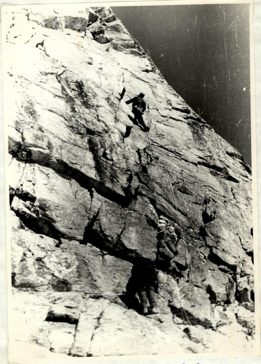
Section R5–R6