Ascent Passport
-
Ascent class: technical
-
Ascent area: Central Caucasus, northern spur of the Main Caucasian Range, branching off from Mestia-tau peak, Djailyk knot between Donkin and Killar passes.
-
Peak — its height, ascent route: Djailyk 4533 m, combined route via south-southwest wall of the southern ridge.
-
Estimated difficulty category: 5B
-
Route characteristics:
- Height difference: 890 m.
- Average steepness up to the summit ridge: 64°.
- Average steepness of the most difficult "key" part of the route: 89°.
- Length of the "key" part of the route (including traverses): 320 m.
- Length of sections by difficulty categories:
- 6th cat. diff.: 226 m.
- 5th cat. diff.: 220 m.
- 4th cat. diff.: 315 m.
- 3rd cat. diff.: 250 m.
- 2nd cat. diff.: 300 m.
-
Pitons driven:
- For belaying:
- Rock: 97
- Ice: 8
- Bolt: 2
- For creating artificial holds:
- Rock: 30
- Bolt: 2
- For belaying:
-
Total climbing hours – 27.5 h
-
Number of bivouacs and their characteristics: total bivouacs – 4;
- I – on the glacier in a tent under the start of the route;
- II, III – on a snow shelf in a tent at the start of the "key" part of the route;
- IV – on the summit ridge in a tent.
-
Surname, name, patronymic of the group leader, participants, and their sports qualification:
- Laskavyi Dalian Pavlovich – Candidate Master of Sports of the USSR
- Davydov Aleksey Petrovich – Master of Sports of the USSR
- Karabash Vladimir Alekseyevich – Master of Sports of the USSR
- Forostyan Vitaliy Yuryevich – Candidate Master of Sports of the USSR
- Shakalo Valeriy Matveyevich – Candidate Master of Sports of the USSR
-
Team coach: Master of Sports of the USSR, senior mountaineering instructor Popov Viktor Pavlovich.
-
Date of departure on the route and return: June 16–20, 1978.
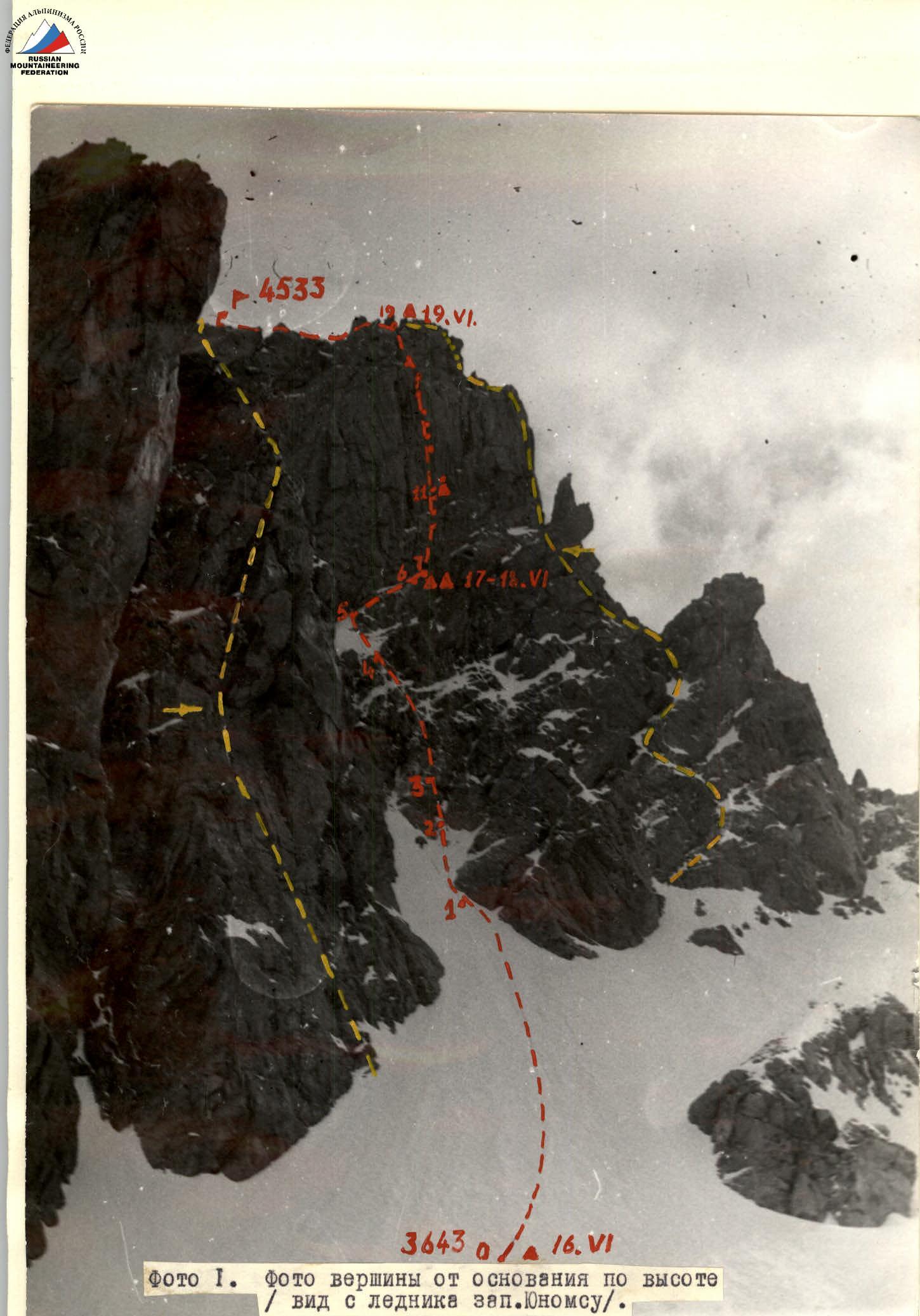
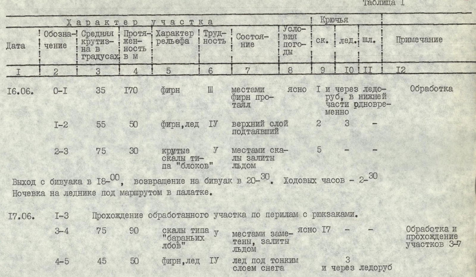
Table I
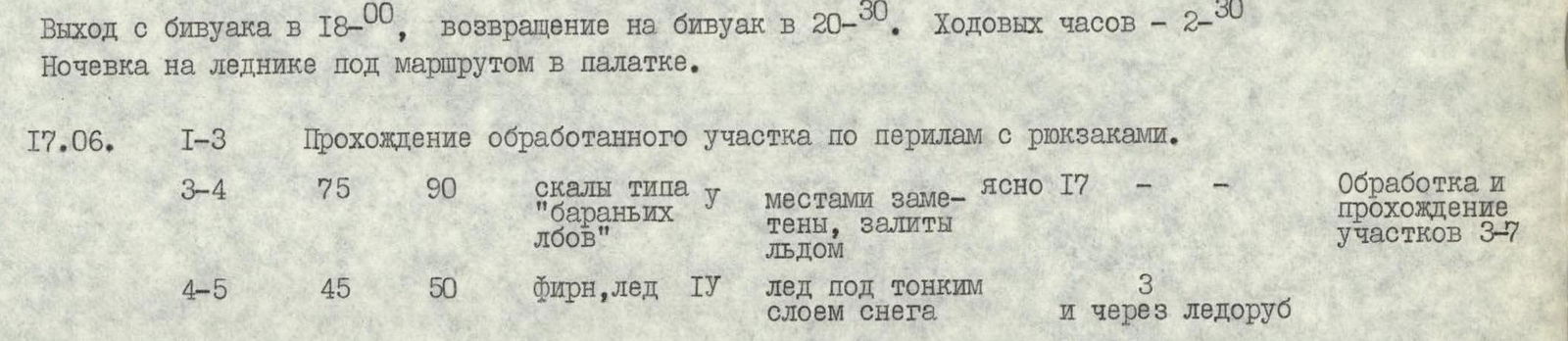
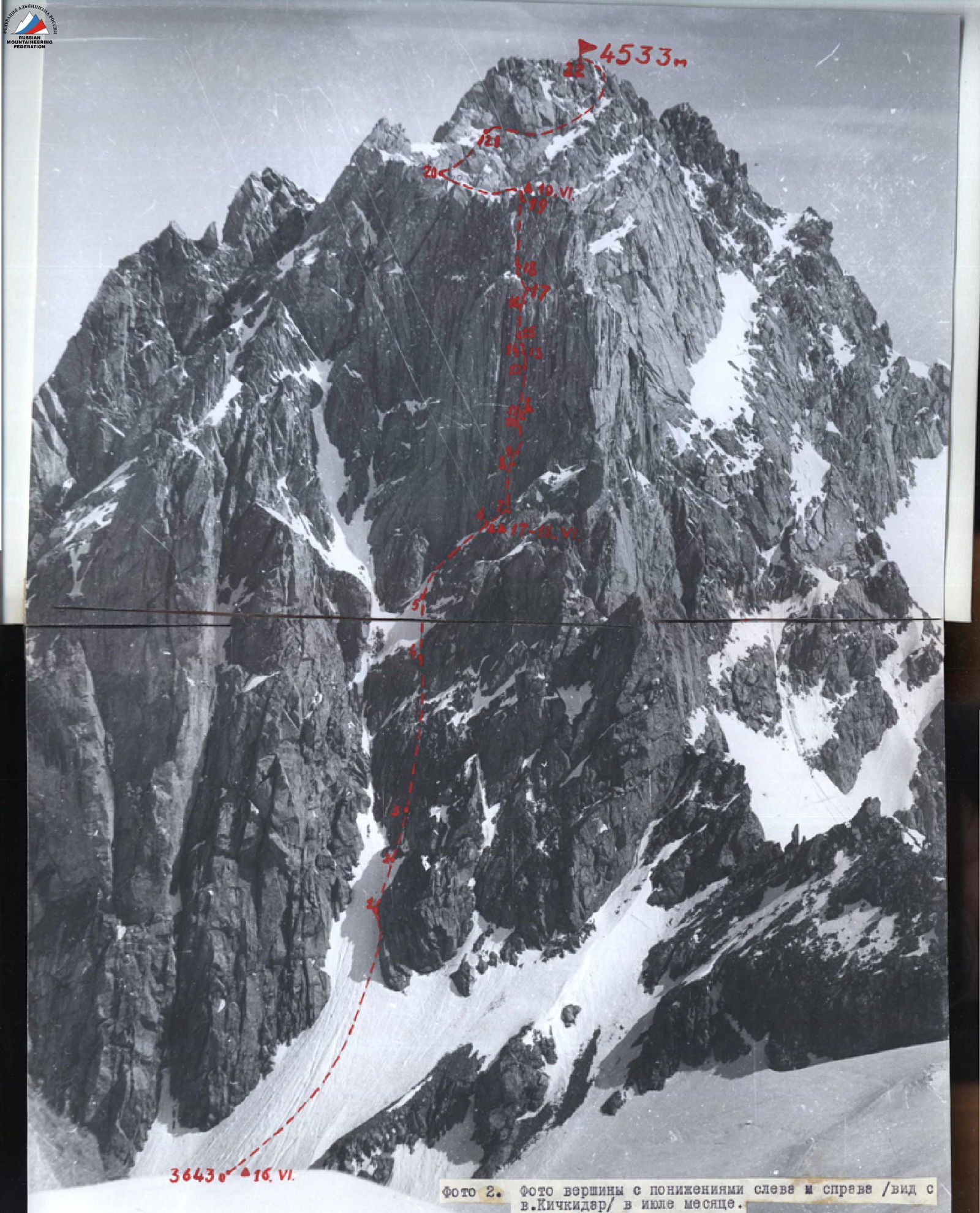
Photo 2. Photo of the peak with depressions on the left and right (view from v. Kichkidar) in July.
| Date | Designation | Average steepness in degrees | Length in m | Terrain character | Difficulty category | Condition | Weather conditions | Rock pitons | Ice pitons | Bolt pitons | Note |
|---|---|---|---|---|---|---|---|---|---|---|---|
| June 16 | R0–R1 | 35 | 170 | firn | 3 | местами фирн протаял | ясно | 1 | и через ледоруб | Обработка, в нижней части одновременно | |
| R1–R2 | 55 | 50 | firn, ice | 4 | верхний слой подтаявший | 2 | 3 | — | — | ||
| R2–R3 | 75 | 30 | steep rocks like "blocks" | 5 | местами скалы залиты льдом | 5 | — | — | — | ||
| June 16 | Выход с бивуака в 18:00, возвращение на бивуак в 20:30. Ходовых часов – 2 ч 30 мин. Ночевка на леднике под маршрутом в палатке. | ||||||||||
| June 17 | R1–R3 | Прохождение обработанного участка | по перилам с рюкзаками | ||||||||
| R3–R4 | 75 | 90 | rocks like "sheep's foreheads" | местами заметены, залиты льдом | ясно | 17 | Обработка и прохождение участков R3–R7 | ||||
| R4–R5 | 45 | 50 | firn, ice | 4 | лёд под тонким слоем снега | 3 | и через ледоруб | ||||
| R5–R6 | 30 | 70 | inclined shelf | 3 | заснеженная, заледенелая | ясно | 6 | выступы | Движение вправо вверх под углом 30° по полке | ||
| R6–R7 | 30 | 10 | «-» | 3 | выступы | «-» | |||||
| R7–R8 | 90 | 40 | Rock wall with few holds | 6 | Монолит | 8 | — | — | Обработка участков R7–R11, движение вверх немного забирая вправо | ||
| R8–R9 | 40 | 15 | Oblique sloping shelf, adjacent wall is smooth, almost without holds | 6 | залита натечным льдом | 3 | — | — | Движение вправо вверх по покатой полке под углом 40°, крутизна стены 90° | ||
| R9–R10 | 95° | 40 | Vertical crevice | 6 | монолит | 6, 4 | — | — | — | ||
| R10–R11 | 160 | 1.5 | Cornice | 6 | монолит | 3 | — | Над карнизом, п. II, контрольный бур | |||
| June 17 | Выход с бивуака в 7:00, остановка на бивуак 17:00 (с учётом времени обработки участков R7–R11). Ходовых часов 10. Ночёвка на полке в п.6 в палатке. | ||||||||||
| June 18 | R11–R12 | 95 | 40 | Wall, short, wide, deep crevices | 6 | монолит | First half of the day – variable cloudiness, second – wind, snow | 6, 8 | — | Обработка участков R11–R14 | |
| R12–R13 | 120 | 5 | cornice like "sheep's forehead" | 6 | монолит | 1, 3 | 1 | ||||
| R13–R14 | 120 | 5 | «-» | 6 | «-» | 1, 2 | 2 | ||||
| June 18 | Выход с бивуака в 7:30, возвращение на бивуак в 13:00 в связи с резким ухудшением погоды. Ходовых часов 5 ч 30 мин. Ночёвка в п.6 в палатке. | ||||||||||
| R7–R14 | Прохождение обработанных участков | по перилам. Подъем рюкзаков | |||||||||
| R14–R15 | 90 | 15 | rock wall | 6 | монолит | Variable cloudiness, in the second half of the day sleet, strong wind | 3, 1 | — | Обработка и прохождение участков R14–R19. Траверс влево под углом 30° | ||
| R15–R16 | 80 | 50 | crevice – chimney | 6 | монолит | 8, 4 | — | ||||
| R16–R17 | 120 | 15 | cornice like "sheep's forehead" | 6 | монолит | 6, 5 | 1 | Карниз проходится слева направо под углом 45° | |||
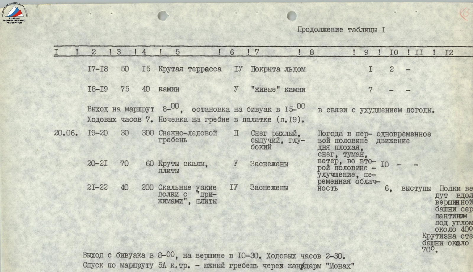
| R17–R18 | 50 | 15 | Steep terrace | 4 | Покрыта льдом | 1 | 2 | — | |||
| R18–R19 | 75 | 40 | chimney | 5 | «живые» камни | 7 | — | — | |||
| June 18 | Выход на маршрут 8:00, остановка на бивуак в 15:00 в связи с ухудшением погоды. Ходовых часов 7. Ночёвка на гребне в палатке (п.19). | ||||||||||
| June 20 | R19–R20 | 30 | 300 | Snow-ice ridge | 2 | Снег рыхлый, сыпучий, глубокий | Weather in the first half of the day is bad, snow, fog, wind, in the second half – improvement, variable cloudiness | одновременное движение | |||
| R20–R21 | 70 | 60 | Steep rocks, slabs | 5 | Заснежены | 10 | |||||
| R21–R22 | 40 | 200 | Rock narrow shelves with "presses", slabs | 4 | Заснежены | 6 | выступы | Полки ведут вдоль вершинной башни серпантином под углом около 40°. Крутизна стены башни около 70° |
Выход с бивуака в 8:00, на вершине в 10:30. Ходовых часов 2 ч 30 мин. Спуск по маршруту 5А кат. сл. – южный гребень через жандарм «Монах» и в тот же день в а/л «Джайлых». Всего ходовых часов – 27–30 ч.
Route Description
From the bivouac in the snow depression on the west Djailik-su glacier under the south-southwest wall of Djailyk peak, ascend directly up the snow-ice couloir, narrowing in the upper part and turning into an ice-rock gully (about 220 m up, ice steepness on the last 50 m – 50–60°). At the beginning of the narrow (upper) part of the gully – transition to rocks. Rocks are steep, местами залиты льдом, climbing is difficult, belaying is with pitons. Go vertically up, slightly deviating to the right. First, climb rocks in the form of large piled blocks (30 m), and then rocks like "sheep's foreheads" (90 m) to exit onto a steep (45–50°) snow-ice slope with a length of about 50 m. The slope is climbed vertically up with alternating belaying through ice pitons to the base of the upper "key" part of the route, which is a monolithic 250-meter rock wall with several cornices. The wall is cut in the central part by a giant chimney, along the entire base of the "key wall" stretches a narrowing, then expanding snow-ice shelf. Along the shelf to the right – up to the chimney (70 m) and further 10–15 m to a convenient platform for organizing a bivouac under a 2-meter rock cornice (from the bivouac on the glacier 8–10 hours). Belaying is with pitons and, where possible, through outcrops. Passing the wall through the chimney (as assumed by the initial tactical plan) turned out to be impractical, as the chimney is too wide (up to 3 m) for free climbing using chimney technique, and its inner side walls are smooth and have almost no crevices for driving pitons.
Therefore, the group, avoiding the use of a large number of bolt pitons, went along the rocks slightly to the right (10–15 m) of the chimney. From the bivouac along the shelf another 10 m to the right and then up-left along the wall rocks.
Rocks are monolithic with interrupted vertical crevices. Extremely difficult free climbing (40 m) to an oblique and sloping long rock shelf. Exit onto the shelf in its lower part. Further, transition along the shelf to the right (on the shelf – flowstone ice) 15 m to a vertical crevice in overhanging rocks. Along the crevice 40 m vertically up with the use of artificial holds to a small rock cornice with two protruding stones like "feathers".
Above the cornice, a small shelf (can stand one person). Convenient place for organizing belaying. At this place – control tour (can on a rock piton). From the bivouac under the "key" wall 4–6 hours. From the shelf up-left in the direction of two sequentially located rock cornices in the form of overhanging "sheep's foreheads" 50 m. Cornices are passed in their left part. Crevices are short, wide, deep. Free climbing is extremely difficult and often alternates with the use of artificial holds. For passing this section, закладные крючья различных размеров are necessary. In the place of passage of the upper part of the cornices, three bolt pitons were driven.
After passing the cornices, a complex transition to the left up 15 m along smooth steep rocks to a vertical crevice, expanding in the upper part and turning into a chimney. The chimney leads under the third large rock cornice like an overhanging "sheep's forehead". From the beginning of the crevice to the cornice 50 m. The character of the crevices is the same, rocks are monolithic, holds are small and smoothed. The cornice is passed from left to right with the use of artificial holds on закладные крючья; for organizing reliable belaying, another bolt piton was driven. Behind the cornice – a steep snow-ice terrace (15 m), leading to the base of the chimney from large rock blocks. Along the chimney straight up to the exit onto the bottom ridge 40 m. End of the "key" section. On the ridge, organization of a bivouac is possible.
Further:
- along the horseshoe-shaped snow-ice ridge to the left 300 m to the base of the summit tower;
- then up to the right along difficult rocks about 70 m to exit onto a system of rock shelves with "presses", encircling the summit tower from left to right in the form of a serpentine;
- along the shelves, and then along inclined slabs – exit onto the summit through 200 m.
From the place of exit onto the ridge about 3 hours.