
Chil'mana – Individvumchorr, traverse, Turchaninov I.V., 1999, Khibiny, 8.6.2.
Passport
- Small mountains. Technical class.
- Khibiny. Western part.
- Traverse: Chil'mana Mt. (824 m) – Yumechorr Mt. (1097 m) – Fersmana Mt. (1179 m) – Yudychvumchorr Mt. (1200 m) – Chasnachorr Mt. (1189 m) – Individvumchorr Mt. (1078 m).
- First ascent. Presumably 3A category of difficulty, combined, between November 1 and May 31.
- Total route length – 21 km.
Length of sections:
2B category of difficulty – 1800 m, 3B category of difficulty – 205 m.
- Hooks left on the route – 1 piece.
Hooks driven:
| rock | chocks | ice |
|---|---|---|
| 12/0 | 5/0 | 1/0 |
- Travel hours – 26 hours, days – 5.
- Overnights: 1st, 2nd – in a tent, 3rd, 4th – in snow caves.
- Team leader: Turchaninov I.V. – Candidate Master of Sports, participants: Nazarov S.N. – 2nd sports category, Abrashkevich M.V. – 2nd sports category.
- Coach: Shaginyan I.E. – Master of Sports.
- Approach to the route: March 11, 1999.
Descent from the route: March 15, 1999.
- Moscow City Federation of Alpinism and Rock Climbing.
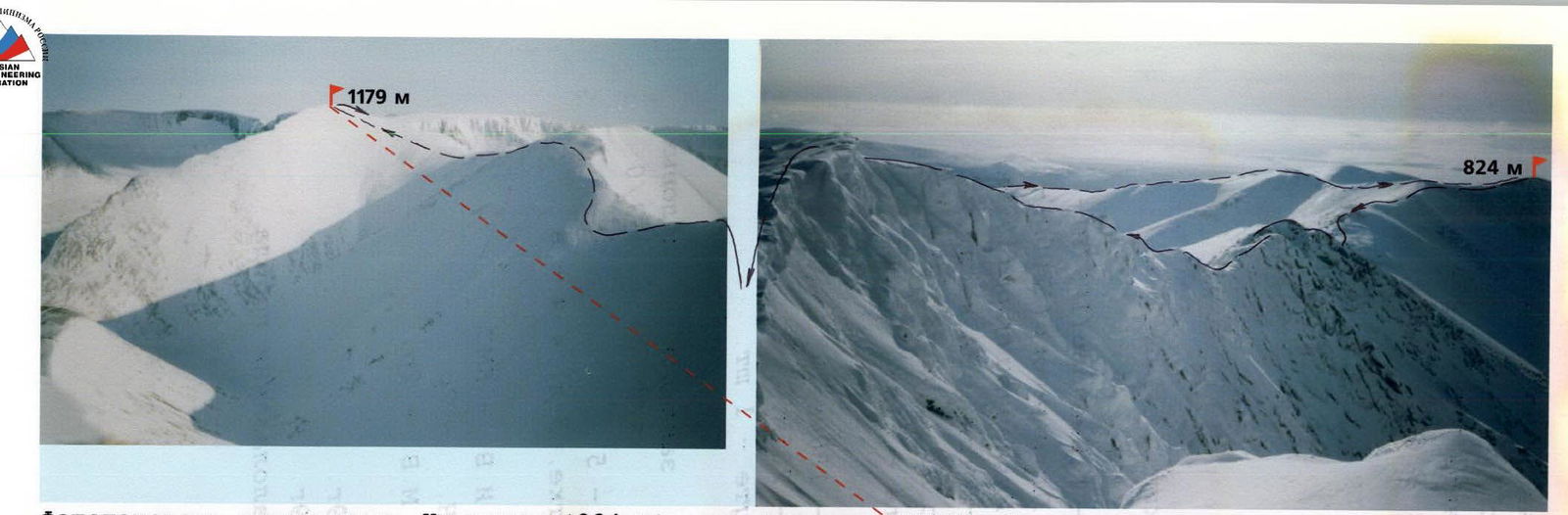
Photopanorama of the traverse Chil'mana Mt. (824 m) – Fersmana Mt. (1179 m). Taken from the summit of Yumechorr Mt. (1097 m) on March 12, 1999 at 14:00.
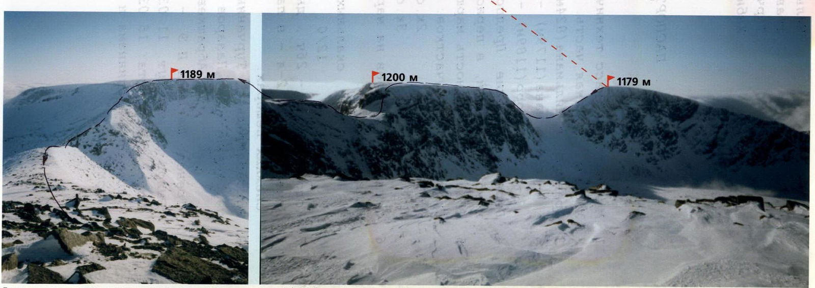
Photopanorama of the traverse Fersmana Mt. (1179 m) – Chasnachorr Mt. (1189 m). Taken from the summit of Individvumchorr Mt. (1078 m) on March 15, 1999 at 16:30.

Area map. Scale 1:100 000
- route taken
- overnight locations
Brief Overview of the Area
The Khibiny Mountains are not very high and are circular in shape with a radius of about 30 km. This is a very old mountain range, heavily glaciated and eroded. Almost all mountain peaks are vast plateaus with gentle, rounded shapes, sometimes breaking off into sheer granite walls.
At first glance, the mountains seem not very challenging. However, this impression is misleading, and even with extensive experience, it's hard to gauge the scale and height of these walls by eye. Mainly because they are composed of monolithic blocks, typically around:
- five by five meters,
- ten by ten meters.
The average height of the wall sections is about six to seven hundred meters.
Winter weather conditions are very harsh. Severe frosts and constant winds make ascents extreme. It's essential to have skis and crampons, as the snow is very deep and loose on the approaches, and the firn at the top is so hard that it's sometimes impossible to stick an ice axe handle into it. Often, on rocks of any steepness, there's "Khibiny rime" – accretions of dense, needle-like snow that grow under the influence of the wind.
One must always remember that the weather in Khibiny is extremely unstable, and sunshine can be followed by a snowstorm, gusty winds, or fog. So, having a good compass is essential.
It's also worth considering that due to the rounded shapes of the mountains, it's practically impossible to shelter from the wind in Khibiny. The wind speed at the top often reaches 30 m/s. It's necessary to:
- dress warmly
- always have windproof goggles handy
The most favorable time for winter ascents is March. The daylight hours are about 10 hours, and it's often sunny and clear. The average air temperature fluctuates around ten degrees below zero, but severe frosts are not excluded, especially at night.
The idea to traverse twenty kilometers in winter was conceived long ago. Firstly, because it's objectively safe and not too technically difficult. Secondly, it's an excellent opportunity to see the biggest walls, take photos, and form one's own opinion about them. Thirdly, it's just a good chance to train and test equipment.
The route is also good because from almost any pass, one can safely and easily descend on skis into the forest zone, either:
- into the valley of the Malaya Belaya River and reach the "Khibiny" station,
- into the valley of the Kuniyok River, where the EMERCOM base is located and people live.
We didn't have information on whether anyone had previously taken this route. It's only known that mountain tourists climbed individual plateaus and traversed some of them to neighboring passes in different years.
Team Tactics
March 11
We leave Khibiny station at 8:00 AM and start moving along the Malaya Belaya River upstream. The air temperature is –20 °C. After half an hour, the sun rises, and it gradually gets warmer. We walk about four kilometers and turn left. We cross to the other bank on the ice covered with snow and start ascending the southern ridge of Chil'mana Mt. at 13:00. At the top, we can walk without skis; hard firn alternates with sections of not very deep snow. As we ascend, the wind strengthens, but the temperature remains steady at –14 °C. We reach the summit at 16:00; the highest point (824 m) is west of the main peak (to the left of the direction of travel). The connecting ridge, about 500 meters long, is narrow and sharply drops to the north. There are a few small firn cornices. We build a cairn and leave a note inside.
We then move northeast to a large unnamed transverse fault (photo 1). At 17:00, we set up a tent and build a wall from snow blocks to protect against the constant wind, which is about 15 m/s.
March 12
We leave the overnight stop at 11:00 and start ascending the steep slope to the southwestern ridge of Yumechorr Mt. The air temperature is –15 °C. On the ridge, the wind is significantly stronger, making it sometimes hard to stand. After 800 meters, the ridge narrows and is interrupted by a 20-meter-deep fault. We take out a rope and set up a rappel on a convenient boulder.
From the bottom of the fault, we need to climb up the opposite side directly. Turchaninov passes this section with two ice axes and crampons. The rocks, resembling "sheep's foreheads," are only slightly dusted with snow, and thin crevices are filled with ice. We manage to drive in only one rock hook at 15 meters.
After the fault, the ridge becomes very narrow (photo 2), dropping almost vertically to the left and a steep (about 60°) snow-ice slope to the right, with smooth slabs protruding here and there. We move on, alternately belaying each other on rock outcrops and driven hooks.
We reach the summit of Yumechorr Mt. (1097 m) at 14:00. It's marked by a triangulation tower (photo 3). We tie a can with a note to it and begin descending to the Western Arsenyev Pass via a simple firn slope.
From the pass, we ascend to an unnamed elevation and descend to the Eastern Arsenyev Pass. At 16:00, we start building a platform for the tent and constructing a snow wall slightly below the pass, where the snow is not so hard. The air temperature remains at –15 °C. The wind is very strong all day.
March 13
In the morning, there's fog, with visibility around a hundred meters. The wind doesn't cease for a minute. After a long delay, we depart at 11:30. We start ascending Fersmana Mt. via a simple slope.
At 13:00, we reach the highest point (1179 m), marked by a wooden pole. There's nowhere to put a note; everything is snow-covered. After a short rest, we continue moving by compass. And within an hour, we descend to Fersmana Pass (photo 4).
We start ascending Yudychvumchorr Mt. It's immediately clear that crampons alone won't be enough. The slope is steep, and in places, the front teeth scrape against smooth rock. We take out a rope and proceed with alternate belaying through an ice axe. Sometimes, if we search well, we can stick it in up to two-thirds.
At 15:30, we reach the summit plateau. The wind is so strong that even with heavy backpacks, it's hard to stand, and breathing is difficult. The temperature is –12 °C, which feels very cold in such wind. We decide to return to the pass.
At 17:00, we start digging a cave in a hollow slightly below the pass on the southern slope. The cave is ready by 19:30, and we can spend the night warmly and comfortably.
March 14
Again, we can't leave early. We leave our cozy shelter at 11:30 AM. The weather is good; the wind is still not weak, but the sky is clear, and the sun is shining (photo 5). Within an hour and a half, we ascend the summit plateau of Yudychvumchorr Mt. (1200 m) via the familiar path. After another hour and a half, we reach its northern extremity. The plateau drops steeply on all sides.
To descend to the Krestovy Pass, there's only one possible route. It takes about an hour to organize a rappel and descend. There's practically nothing to secure the upper end of the rope to (photo 6). We secure it to a small frozen boulder and an ice axe buried flat in the snow.
The participants descend in the following order:
- Nazarov descends first.
- In the middle of the rappel, he drives in a rock hook and creates an intermediate anchor point.
- Turchaninov descends last, very carefully.
Descent method:
- Up to the hook – by climbing.
- Further – on a double rope with a pull-through.
At 16:00, we decide to descend a bit from the pass and look for a place to spend the night, as a very large plateau of Chasnachorr Mt. lies ahead, and spending the night at the top is out of the question.
At 16:30, we find a snowdrift and start working with a shovel. The cave is ready by 19:30. The wind doesn't cease for a minute.
Before bed, we measure the air temperature. It's cold – minus 27 °C.
March 15
We depart at 11:30. The weather is good, but the wind doesn't cease. It feels like it blows constantly here.
Within an hour, we traverse a fairly steep firn slope with crampons and belaying and reach the Chasnachorr Mt. plateau (1189 m) (photo 7). Half an hour later, we approach a triangulation tower. As usual, we tie a metal can with a note and continue.
At 15:00, after traversing a long, steep slope, we're on the Yuzhny Chorgorr Pass.
At 16:30, we're on the final summit of the traverse, Individvumchorr Mt. (1078 m). We secure another can and, feeling deeply satisfied, start descending along the NE ridge into the Kuniyok River valley.
Upon reaching the forest boundary, we put on skis and reach the PSS base by 19:00, where we can spend the night in a house with a stove for a small fee.
Route Description
- Approach to the route from Khibiny railway station: upstream along the Malaya Belaya River to the second left tributary (4.6 km, azimuth 65°). Then turn north, cross the river on the ice covered with deep, loose snow, and ascend to the forest boundary on the southern ridge of Chil'mana Mt. (0.8 km, 0°). Approach on skis. Further on foot.
- Ascend the simple, gentle southern ridge to the main summit of Chil'mana Mt. (3.2 km, 340°). The highest point of Chil'mana Mt. (Western) is 400 m from the main peak at an azimuth of 290°. Reach the Western summit via a simple but precipitous ridge. Control cairn No.1 made of stones. Before reaching the top, there's a 10-meter rock section of 2nd category complexity. Belaying on a rock outcrop.
- Return to the Main summit via the ascent path and continue moving through the NE summit at an azimuth of 55°. After the NE summit, descend down a broad ridge. A good landmark is large boulders; it's better to bypass them on the right. Descend a hard firn slope into a large, unnamed transverse fault to the right of the direction of travel (0.8 km). Overnight here.
- From the overnight location, ascend 50 meters straight up steep, snow-covered "sheep's foreheads" (belaying through an ice axe) until it levels out. Then ascend the R103 ridge of Yumechorr Mt. to a deep transverse fault (0.8 km). Rappel 25 m.
- Climb directly up the crevices and slabs on the opposite side of the fault of Yudychvumchorr Mt. 15 meters, snow-covered rocks of 3rd category complexity. At the top, belaying through an ice axe or on a large boulder. Then ascend along a narrow, precipitous R03 ridge of 2B–3 category complexity to the summit of Yumechorr Mt. (1097 m) (0.8 km, 45°). The summit is marked by a triangulation sign. On it, a can with a note (C.T. No.2).
- Descend from the summit along the simple firn SE ridge to the Western Arsenyev Pass to the left of the direction of travel (0.7 km, 130°).
- Ascend a small elevation along the left side of a gentle ridge (1.2 km, 110°) and descend to the Eastern Arsenyev Pass (1 km, 75°). Overnight here.
- From the pass, move in a NE direction along a broad firn slope to the summit plateau of Fersmana Mt. (0.7 km, 45°).
- From the summit, turn SE and move along a steep ridge, sticking to the left, precipitous edge (beware of cornices!) towards Fersmana Pass (0.8 km, 110°).
- From Fersmana Pass, a passage along the snow between rock outcrops to the NW extremity of Yudychvumchorr Mt. is visible. Ascend the steep (about 45°) slope to the top (0.5 km, 70°). Hook belaying and through an ice axe. Then move along the plateau, sticking to its left edge towards Krestovy Pass (0.9 km, 70°, transitioning to 50°).
- At the end of the path, the plateau narrows sharply and turns into a narrow ridge ending in a rock drop. 15 meters before the farthest edge, set up a rappel (30 m) to the left of the direction of travel and reach Krestovy Pass.
- From the pass, ascend a steep, narrow ridge to the Chasnachorr Mt. plateau. Belaying through an ice axe (0.4 km, 45°). Then move along the plateau to a triangulation sign (1.2 km, 15°). On the triangulation point, a metal can with a note.
- Descend from the summit to the end of the plateau and then along the right, steep slope towards Yuzhny Chorgorr Pass. Traverse a stony slope and descend to the pass (1.8 km, 25°).
- From the pass, ascend the southern ridge of Individvumchorr Mt. to the right and then to the summit point marked by a triangulation sign (1.4 km, 60°). On the tower, a can with a note is secured.
- From the summit, descend along the long Eastern ridge into the Kuniyok River valley (2.6 km, 75°). Then it's possible to descend on skis to the "Kuel'porr" PSS base and spend the night there.

Photo No.2. Section (5). The second fault on the R103 ridge of Yumechorr Mt. successfully passed. In the background to the right is the highest point of Chil'mana Mt.
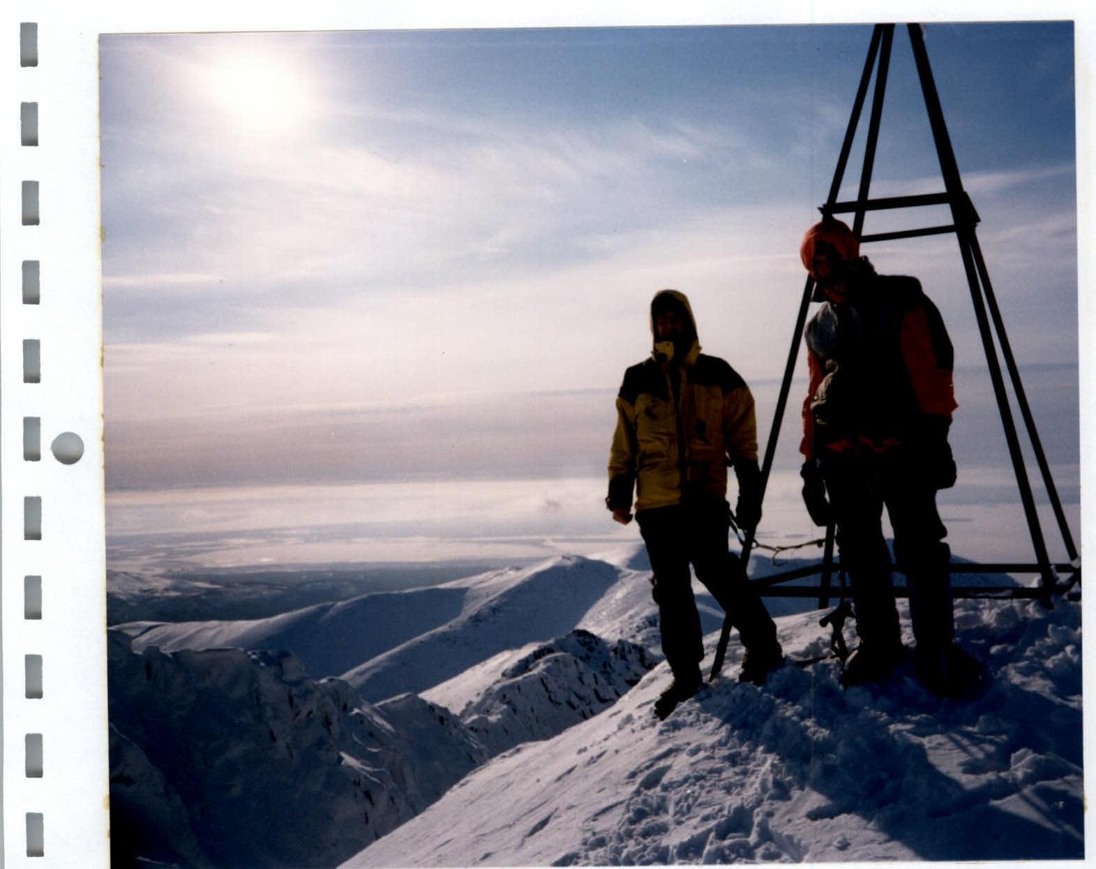
Photo No.3. Section (5). On the summit of Yumechorr Mt. (1097 m) on March 12, 1999, 14:00. To the bottom left is a quite difficult SW ridge.
In the photo: left – I. Turchaninov, right – S. Nazarov, M. Abrashkevich is taking the photo.
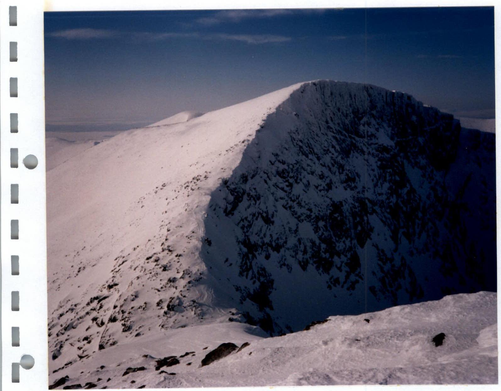
Photo No.4. Section (9). NE ridge of Fersmana Mt. We descended it on March 13 by compass in conditions of visibility not more than 50 meters and very strong winds. Below is Fersmana Pass. The northern wall of the mountain is one of the most complex and highest in Khibiny.
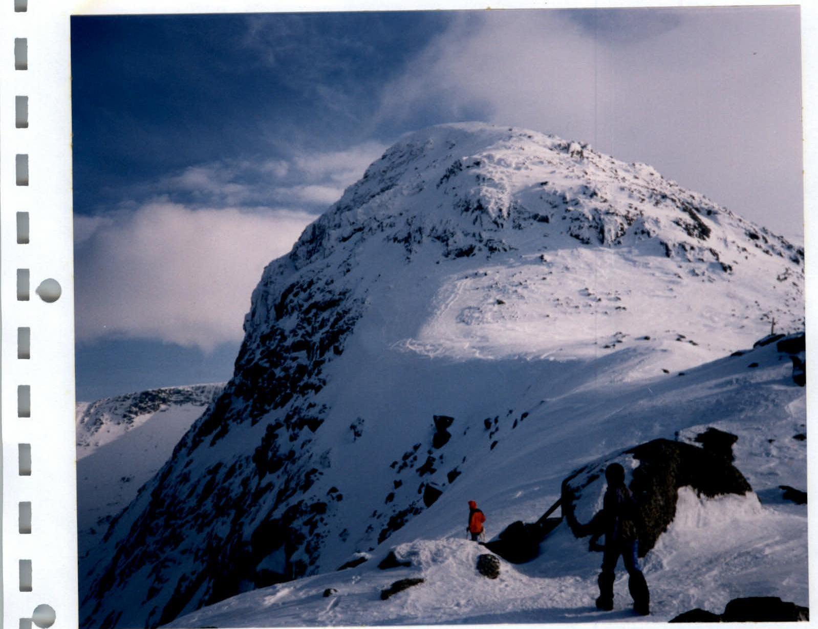
Photo No.5. Section (10). From Fersmana Pass, a passage along the snow between rock outcrops to the NW extremity of Yudychvumchorr Mt. is visible.
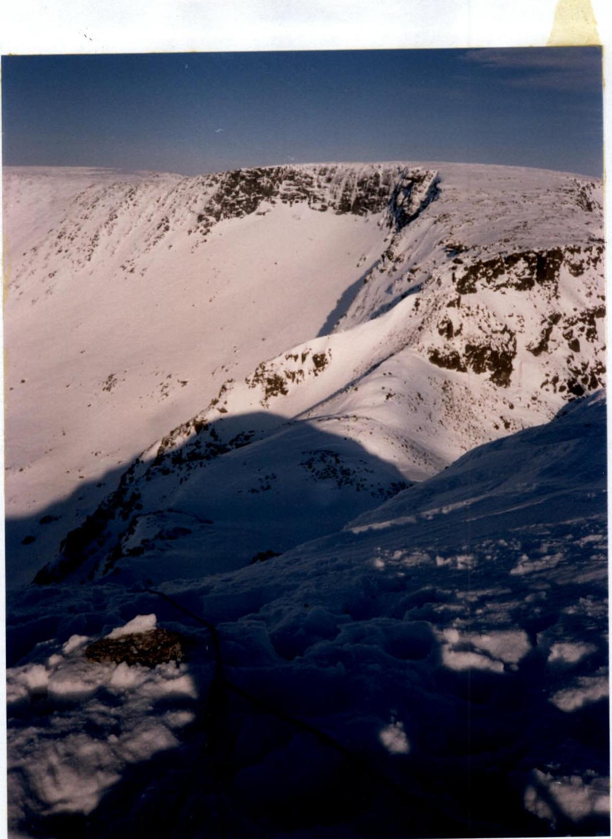
Photo No.6. Section (11). To descend to Krestovy Pass, there's only one possible route. The end of the rappel rope is secured to a small frozen boulder and a buried ice axe, on which the photographer is sitting.
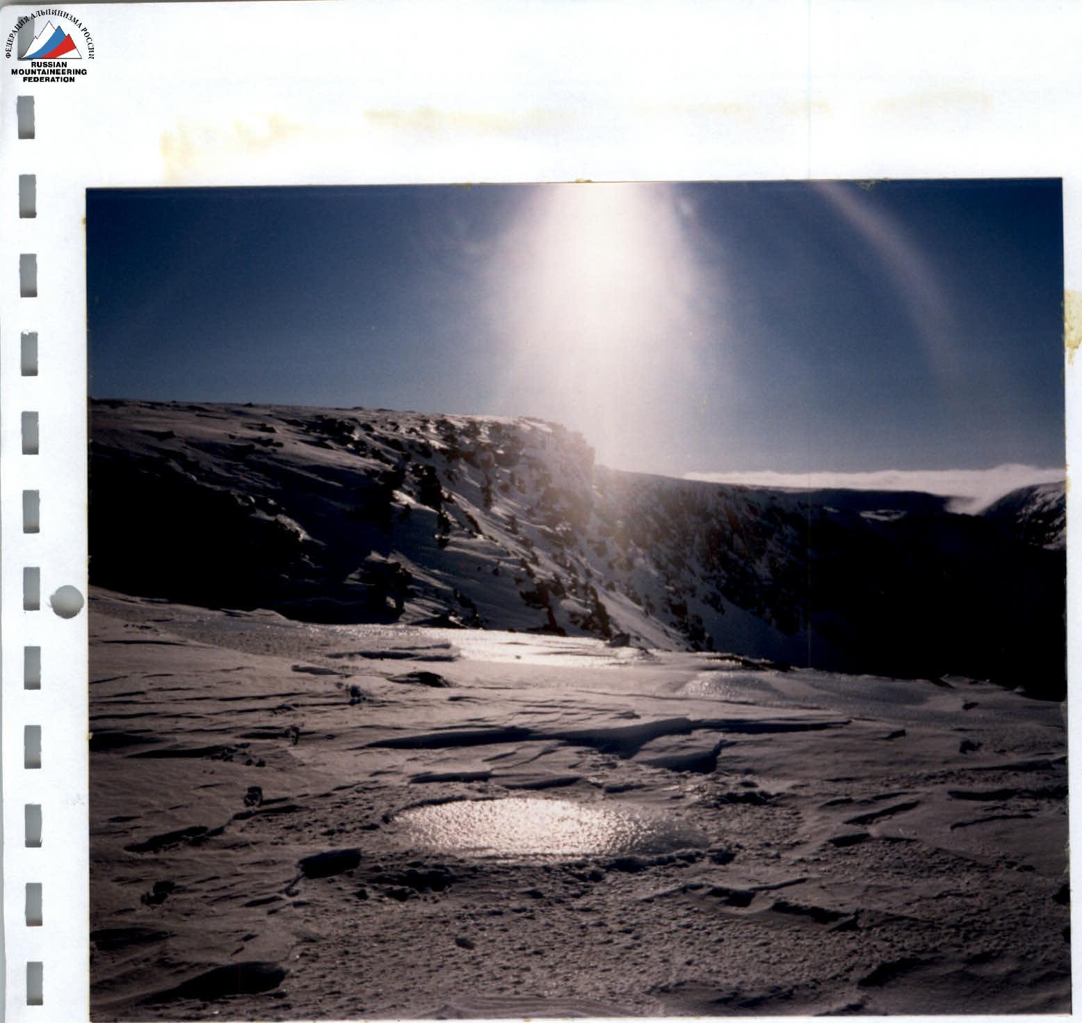
Photo No.7. Section (12). On the Chasnachorr Mt. plateau. Hard firn under the influence of winds and sun gradually turns into ice.