Passport
- Section number according to KMGV — 2010 — 8.3.53
Polar Urals, Rai-Iz mountain range, Sob' river valley
- Name of the summit: 1008.0 Rai-Iz (Small)
height: 1008.0 route: via the northern wall of the central rock tower of the northwestern ridge
-
Category of difficulty: proposed 3A, winter ascent
-
Character of the route — winter ascent.
-
Height difference of the route: 728 m
-
Length of the route: 1220 m
-
Length of sections with the highest category of difficulty:
1st category — 1 section — 300 m, 2nd category — 5 sections — 850 m, 3 — 50 m, 4 — 0 m, 5 — 0 m, 6 — 0 m
-
Average steepness: main part of the route — 65°, total route — 50°.
-
Number of pitons used: Total on the route:
- rock pitons — 10,
- chocks — 11,
- stationary bolts — 0,
- other equipment (ITO) — 0,
- removable bolts — 0. Pitons left on the route: total — 0; including bolts — 0.
- Departure to the route — 7:00, March 7, 2011.
Reached the summit — 14:15, March 7, 2011. Returned to Base Camp — 17:00, March 7, 2011.
-
Team's total climbing hours — 10 hours.
-
Team leader: Bernatsky Sergey Igorevich (Master of Sports, instructor 1st category, Yekaterinburg).
Team members:
- E. Burtsev (3rd sports category, Syktyvkar)
- A. Kruglov (3rd sports category, Vologda)
- D. Falsh (3rd sports category, Moscow region, p. Shikhovskoy)
- Coach: Zhuravlev Sergey Vasilievich, rank — Candidate for Master of Sports, instructor-methodologist 1st category.
Description of the Summit
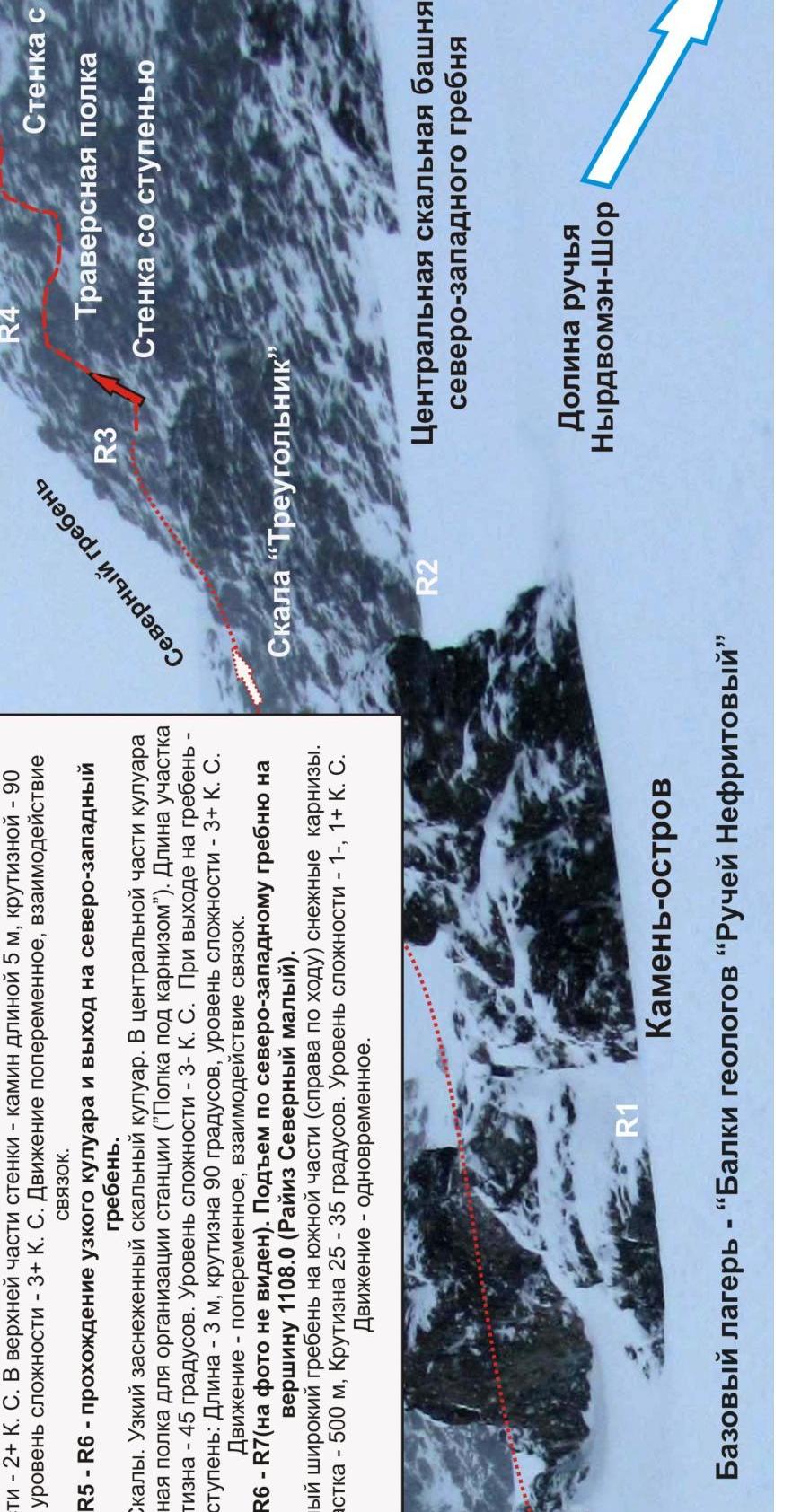
The Rai-Iz (North Small) summit is located in the Yamalo-Nenets National District (YaNAO) of the Tyumen region, Ural Federal District, Russian Federation, 30 km southeast of the 110 km halt (formerly the Polarny settlement), in the valley of the Nyrdvom-Shor stream (a major right-bank tributary of the Sob' river), on the eastern slopes of the Polar Urals. It is the northernmost summit of the Rai-Iz table mountain. The summit is dome-shaped, with a height of 1108.0 m.
The Rai-Iz (North Small) summit can be an object for educational and sports ascents, as it features:
- pronounced rocky ridges,
- corrie ribs on the northern slope,
- a northwestern corrie cirque on the northern slope.
The name of the mountain is official and appears on maps of the Polar Urals. The orographic clarification (North Small) is given for the convenience of orienting climbers, as the main Rai-Iz summit is a table mountain with a vast summit plateau (about 26 km in diameter) that is lower than both Rai-Iz North and Rai-Iz North Small.
Description of the Route: "via the northern wall of the central rock tower of the northwestern ridge (winter)"
Route: via the northern wall of the central rock tower of the northwestern ridge (winter) — a typical winter educational and training route of 3A category of difficulty, with a minimal set of natural obstacles. Passing this route has not only aesthetic but also sports and practical significance, as it allows, within the framework of the ascent, to practice:
- belaying techniques,
- self-belaying techniques on complex rocky terrain.
The route is logical in orientation, objectively safe in winter, which allows for educational, sports, and training ascents.
Equipment
For a team of 6 people (5 participants + instructor) on an educational and sports training route, the following special equipment is required:
Personal:
- Standard issue
- Crampons
- Ice axe — mandatory
Group:
- Main rope 10 mm — 3 × 50 m
- Chock elements — 12 pcs. (two sets)
- Rock pitons — 8 pcs. (preferably short horizontal and Krasnoyarsk anchors)
- Ice screws — 3 pcs.
- Quickdraws — 8 pcs.
- Loops — 6 pcs.
- Rock hammer — 1 pc.
- Ice axe — 1 pc.
Approach
From the base camp — "Geologists' Balk (Nefritovy Stream)" — follow the couloir to the island rock. On the rock, there is a convenient place to organize a belay.
Technical Part
Initially, from the island rock (the place to organize a belay), ascend via the couloir, then along the talus shelf to the "Triangle" rock massif. Further up, via the second rocky "gutter" located between the second and third counterforts of the wall.
The rocky wall is of medium difficulty, with a complex section "Step" in the upper part. From the wall, exit onto a shelf under the "Mirror" wall and traverse right along the path. Then, ascend via a rocky wall of medium difficulty level — in the upper part, there is a short complex section, a chimney.
After passing the chimney:
- move slightly right along small, weakly pronounced shelves
- enter a narrow rocky couloir
This is the key part of the route. There are very few places for intermediate belay points. In the center of the couloir, on the left, there is a shelf under an overhanging cornice, allowing for a station. Further, exit onto the ridge. At the exit, there is a snow cornice that needs to be dug out.
After exiting onto the ridge:
- move upward along destroyed, snow-covered rocks
- reach a steep snow slope — exit onto the pre-summit shoulder (overcome in three moves)
After exiting onto the pre-summit shoulder, the ascent to the summit dome is not difficult.
Descent from the summit via the northern ridge, following the 1B category route.
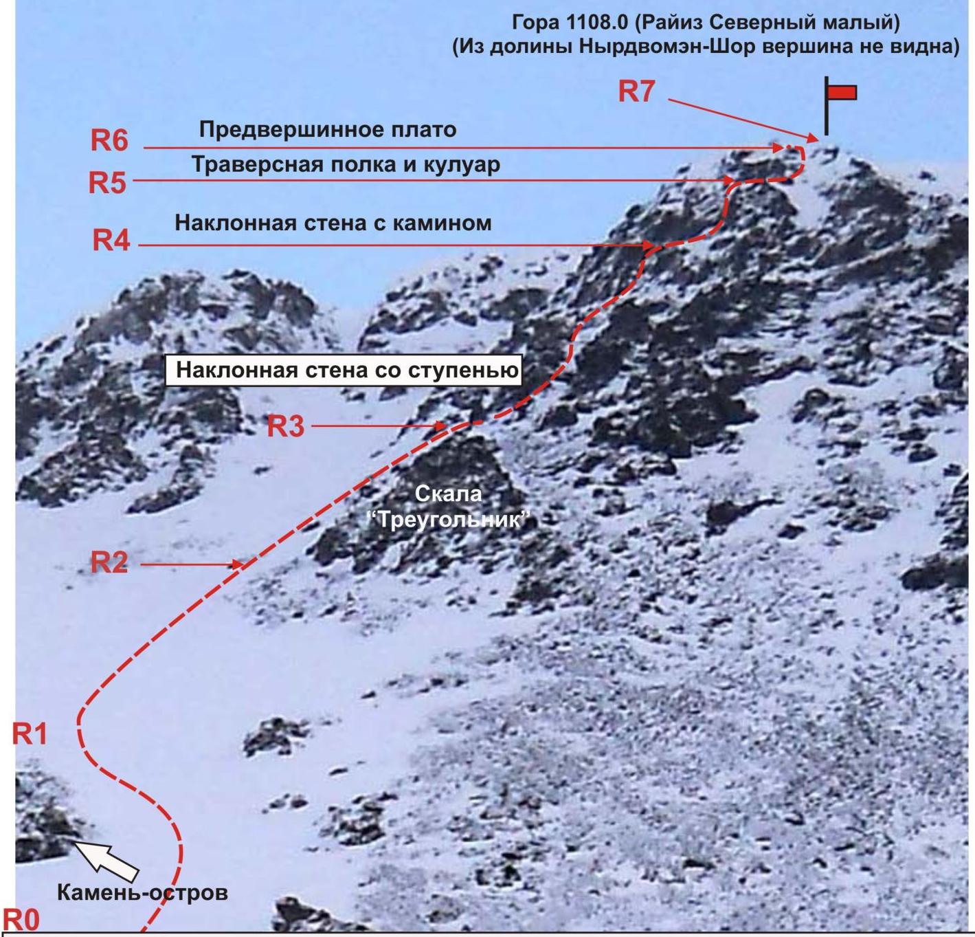
Section R0–R1 — ascent from the base camp "Geologists' Balk 'Nefritovy Stream'" to the island rock.
- Length — 300 m
- Steepness — 30–40 degrees
- Difficulty level — 1-, 2+ category
- Movement — simultaneous
- Self-belay — using an ice axe
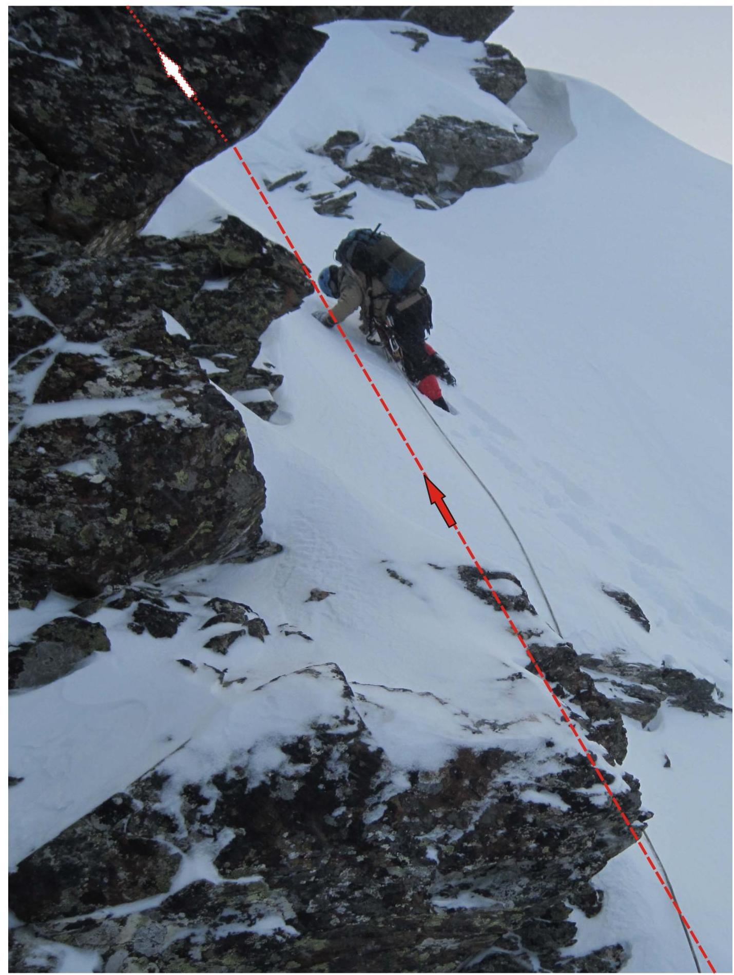
Section R1–R2 — ascent to the start of the rocky ascent. Snowy-icy slope. Length — 200 m. Steepness — 35–45 degrees. Difficulty level — 2-, 2+ category. Movement is simultaneous, belaying with an ice axe.
Section R2–R3 — ascent to the "Triangle" rock under the start of the technical part of the route. Snow-covered rocky shelf. Length — 100 m. Steepness — 45 degrees. Difficulty level — 2- category. Movement is simultaneous. Self-belaying with an ice axe.
Section R3–R4 — passage of the oblique wall with a step. Inclined rocky wall, monolith. Length — 50 m, steepness — 45°. Category — 2+Б. In the upper part — a rocky step:
- Length — 5 m,
- Steepness — 90°,
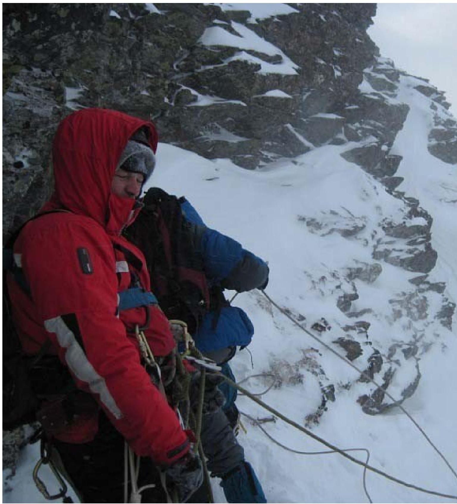
- Category — 3+Б. Movement is alternating, interaction between links. Used:
- Pitons — 3 pcs.,
- Chocks — 8 pcs.
Section R4–R5 — traverse under the "Mirror" rock and passage of an inclined wall with a chimney. Inclined rocky wall. Total length — 65 m, steepness — 50°, category — 2+Б. In the lower part — traverse along a shelf:
- Length — 15 m,
- Steepness — 35°,
- Difficulty level — 2+ category. In the upper part — a chimney:
- Length — 6 m,
- Steepness — 90°,
- Difficulty level — 3+ category. Movement is alternating, interaction between links.
Section R5–R6 — Exit via a rocky, snowy couloir onto the summit plateau of the northwestern ridge. Steep, snowy, rocky couloir. Length — 100 m. Steepness — 45–55°. In the center of the couloir (on the left), there is a convenient rocky shelf ("Shelf under the cornice") for an intermediate station. In the upper part — a rocky step:
- Length — 3 m,
- Steepness — 90°,
- Difficulty level — 3Б category. Movement is alternating, interaction between links.
Section R6–R7 (not visible in the photo) — ascent via the northwestern ridge to the summit 1108.0 (Rai-Iz North Small). Wide ridge, with snow cornices on the southern part (on the right). Length — 500 m, steepness — 25–35 degrees. Difficulty level — 1-, 1+ category. Movement is simultaneous.
Polar Urals. Rai-Iz mountain range. Mountain — Rai-Iz. Summit — 1108.0 (Rai-Iz North Small). Route: "via the northern wall of the central rock tower of the northwestern ridge" (Tower "Bernatsky"). Difficulty level — 3A category. (Winter)
Summit Rai-Iz (North Small)
R6–R7 — passage of the pre-summit ridge and exit to the summit. Snow-covered ridge.
Length — 500 m. Steepness — 35°. Difficulty level — 2Б category.
In the middle, a snowy ascent to the pre-summit shoulder:
- Length — 50 m
- Steepness — 50°
- Difficulty level — 2Б category.
Movement is simultaneous, with alternating movement when exiting onto the pre-summit shoulder of the ridge. Belaying with an ice axe.
R5–R6 — Passage of a narrow rocky couloir with a shelf under a cornice and a step in the upper part. Snow, ice.
- Narrow rocky couloir
- Length — 100 m
- Steepness — 45°
- Difficulty level — 3 category.
In the center of the couloir (on the left), a convenient shelf for the belayer under a rocky cornice. At the exit to the ridge — a rocky step, wall 3 m, 90°, 3+ category. Movement is alternating. Organization of running belays. Used pitons — 3, chocks — 0, ice screws — 2.
R3–R4 — Traverse under the "Mirror" rock and passage of an inclined wall with a chimney. Rocks. Monolith. Length of the shelf — 15 m. Steepness — 35°. Difficulty level — 2+ category.
- Rocky wall 50 m, 50°, 2+ category.
- In the upper part — a chimney 6 m, 90°, 3+ category.
- Movement is alternating. Organization of running belays.
- Used pitons — 2, chocks — 3.
R3–R4 — Passage of an oblique wall with a step. Rocks. Monolith. Length 50 m. Steepness — 45°. Difficulty level — 2+ category.
In the upper part of the wall, a step — a rocky wall 5 m, 90°, 3+ category. Movement is alternating.
Organization of running belays. Used:
- pitons — 3
- chocks — 8
R2–R3 — Ascent along an inclined shelf under the bastion of the tower to the "Triangle" rocks. Inclined, talus shelf. Length 100 m. Steepness — 45°. Difficulty level — 2- category. Movement is simultaneous. Self-belaying with an ice axe. Used:
- pitons — 0
- chocks — 0
R1–R2 — Ascent via the couloir to the inclined shelf of the "Triangle" rock. Snowy slope. Length 200 m. Steepness 35–45°. Difficulty level — 2-, 2+ category. Movement is simultaneous. Self-belaying with an ice axe.
R0–R1 — Ascent along a snowy slope to the island rock. Snowy slope. Length 300 m. Steepness 30–40 degrees. Difficulty level — 1+, 2- category.

Section R3–R4 — Passage of an oblique wall with a step. Rocks. Monolith. Length 50 m. Steepness — 45 degrees. Difficulty level — 2+ category. In the upper part of the wall, a step:
- Rocky wall 5 m, 90 degrees, 3+ category.
Movement is alternating. Organization of running belays.
R4–R5 — Passage of a snowy, narrow couloir with a shelf under a cornice and a rocky step in the upper part. Snow, ice. Narrow rocky couloir. Length — 100 m. Steepness — 45°. Difficulty level — 3 category.
- In the center of the couloir (on the left), a convenient shelf for the belayer under a rocky cornice
- At the exit to the ridge — a rocky step
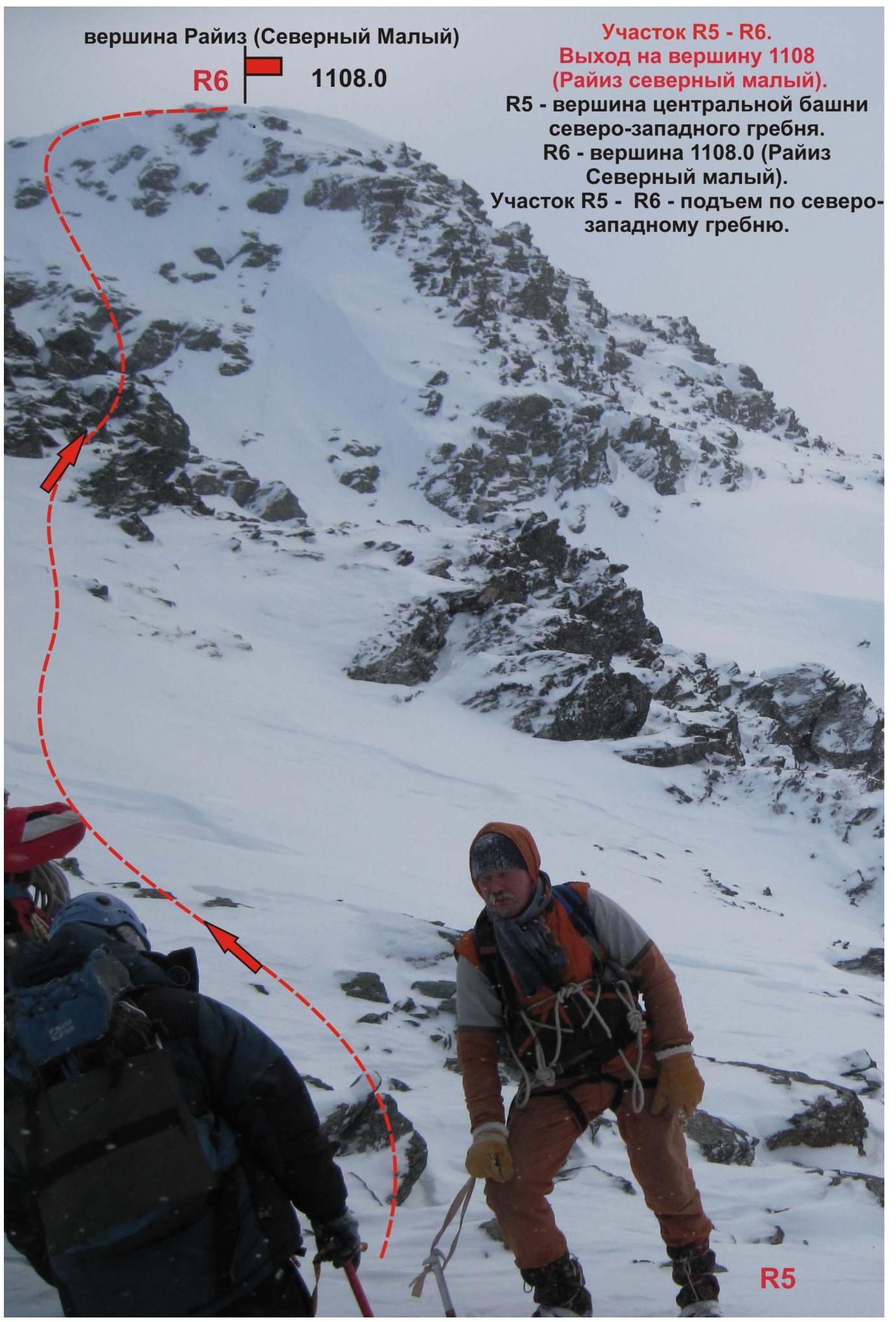
Section R5–R6. Exit to the summit 1108 (Rai-Iz North Small).
- R5 — summit of the central tower of the northwestern ridge.
- R6 — summit 1108.0 (Rai-Iz North Small).
- Section R5–R6 — ascent via the northwestern ridge.