
Passport
- Section number according to KMGV — 2010 — 8.3.52
Polar Urals, Rai-Iz mountain massif, Sob River valley
- Name of the peak: 1108.0 Rai-Iz (North Small)
height: 1108.0 m, route: Along the rocky slope of the northwestern ridge («Two couloirs»)
- Category of difficulty: proposed 2Az, pp.
- Character of the route — winter.
- Height difference of the route: 728 m
- Length of the route: 1549 m
- Length of sections with the highest category of difficulty:
1st cat. diff. — 2 sections — 1000 m, 2nd cat. diff. — 3 sections — 240 m, 3 — 0 m, 4 — 0 m, 5 — 0 m, 6 — 0 m
- Average steepness: main part of the route — 70 degrees.
entire route — 55 degrees
9. Pitons used:
Total pitons used on the route:
- rock pitons — 2
- chocks — 4
- stationary pitons — 0
- ITO — 0
- removable pitons — 0
Pitons left on the route: total — 0; including stationary pitons — 0.
- Departure to the route — 5:00, March 8, 2011
Reached the summit — 12:15, March 8, 2011. Returned to the base camp — 16:00, March 8, 2011
- Team's walking hours: — 10 hours.
- Team leader: Vladimir A. Toropov (1st sports category, Syktyvkar).
Team members:
- Yu. Bykhovtsova (3rd sports category, Syktyvkar)
- O. Moiseeva (3rd sports category, Syktyvkar)
- A. Seleznev (3rd sports category, Ukhta)
- A. Golovnya (3rd sports category, Ukhta)
- P. Meldazhis (3rd sports category, Syktyvkar)
- A. Korobov (3rd sports category, Belgorod).
- Coach: Sergei V. Zhuravlev, title — CMS, 1st category instructor-methodologist.
Note: The route was completed as part of the Championship and Primacy of the NP «Club of Northern Travelers «Sauk-Pai»» in mountaineering in 2011 in the class of «First Ascent».
Description of the peak
The Rai-Iz (North Small) peak is located in the Yamalo-Nenets National Okrug (YaNAO) of the Tyumen Oblast, Ural Federal District of the Russian Federation, 30 km southeast of the 110 km halt (formerly Polar settlement), in the valley of the Nyrdvomen-Shor stream (a large right-bank tributary of the Sob River), on the eastern slopes of the Polar Urals, and is the northernmost peak of the Rai-Iz table mountain. The peak is dome-shaped, with a height of 1108.0 m.
The Rai-Iz (North Small) peak can be an object for educational and sports ascents, as it has:
- several pronounced rocky ridges,
- corrie ribs on the northern slope,
- a northwestern corrie cirque on the northern slope.
The name of the mountain is official and appears on maps of the Polar Urals; the orographic clarification of the peak (North Small) is given for the convenience of orientation for mountaineers, as the main peak of Rai-Iz — a table mountain with a vast summit plateau (about 26 km in diameter) — is lower than Rai-Iz North and Rai-Iz North Small.
Description of the route: (along the northern rocky slope and northwestern ridge («Two couloirs»)) (winter). 2A category of difficulty.
Route: «Along the northern rocky slope and northwestern ridge («Two couloirs») (winter)» — a characteristic winter training route of 2A category of difficulty, having a minimal set of natural obstacles.
Completing this route has not only aesthetic but also practical sports significance, as it allows, within the framework of the ascent, to work out:
- belaying techniques
- self-belaying techniques on snowy-icy and rocky terrain in winter conditions.
The route is logical in orientation, objectively safe in winter time, which allows for educational, sports, and training ascents. The name of the route — «Two couloirs» — is associated with a characteristic feature of this route.
Equipment
To complete the ascent as part of an educational and sports group of 6 people (5 participants + instructor), the following special equipment is necessary on the route:
Personal (mandatory):
- standard
- crampons
- ice axe
Group:
- main rope 10 mm — 3 pieces of 50 m
- chock elements — 4 pieces
- rock pitons — 4 pieces
- ice screws — 3 pieces
- quickdraws — 8 pieces
- slings — 6 pieces
- rock hammer — 1 piece
- ice axe — 1 piece
Approach
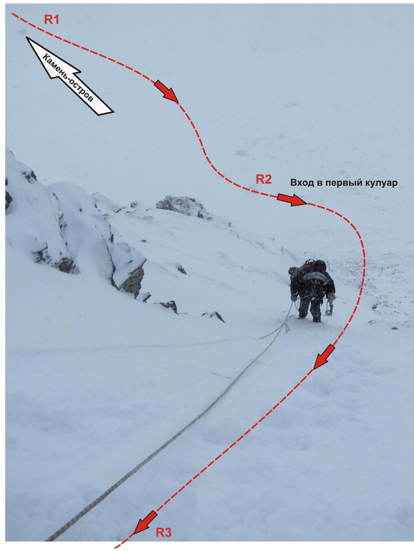
From the base camp — «Geologists' Balki «Nephrite Stream»» — walk along the couloir to the island-rock. On the rock, there is a convenient place to organize rope teams.
Technical part
Initially, from the island-rock (place of organizing rope teams), ascend the slope to the right of the central rocky tower to the base of the couloir between the «Triangle» rock and the «Rhombus» rock. Then:
- ascend the first couloir, leaving two elongated rocky masses to the right (in summer — a poorly expressed rocky outcrop);
- reach an inclined shelf and traverse (direction — to the right) the rocky outcrop.
The key to the route: a narrow snowy-icy couloir 80 m long, with a steepness of 65°, and in the upper part — 80°, leading to the northwestern ridge. The ridge is relatively gentle and wide, so after exiting onto the ridge, the route does not present technical difficulties, all the way to the dome-shaped summit.
Descent from the summit
Descent along the northern ridge via the 1B category of difficulty route.
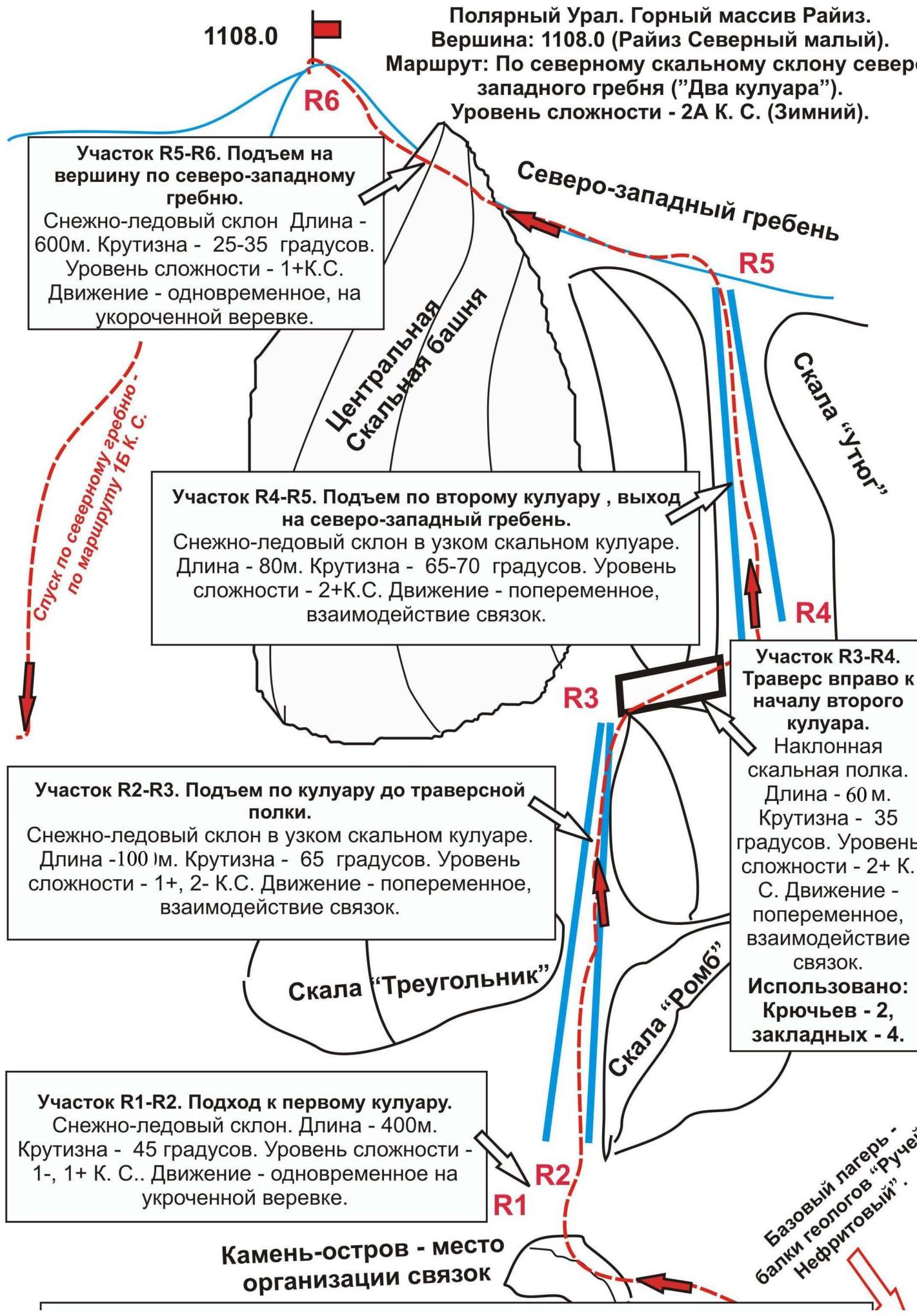
Island-rock — place of organizing rope teams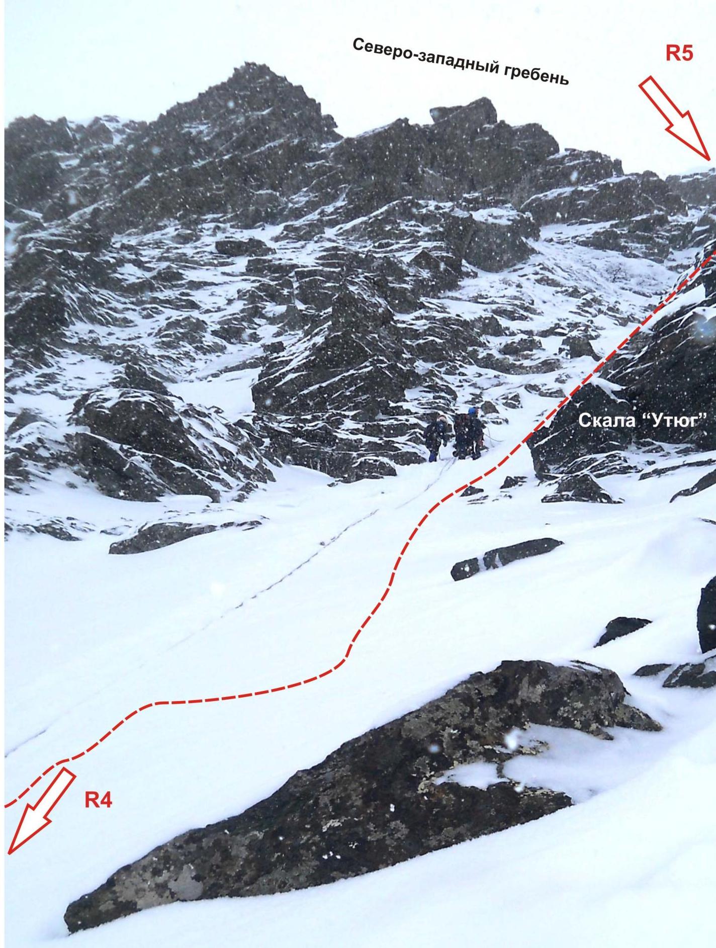
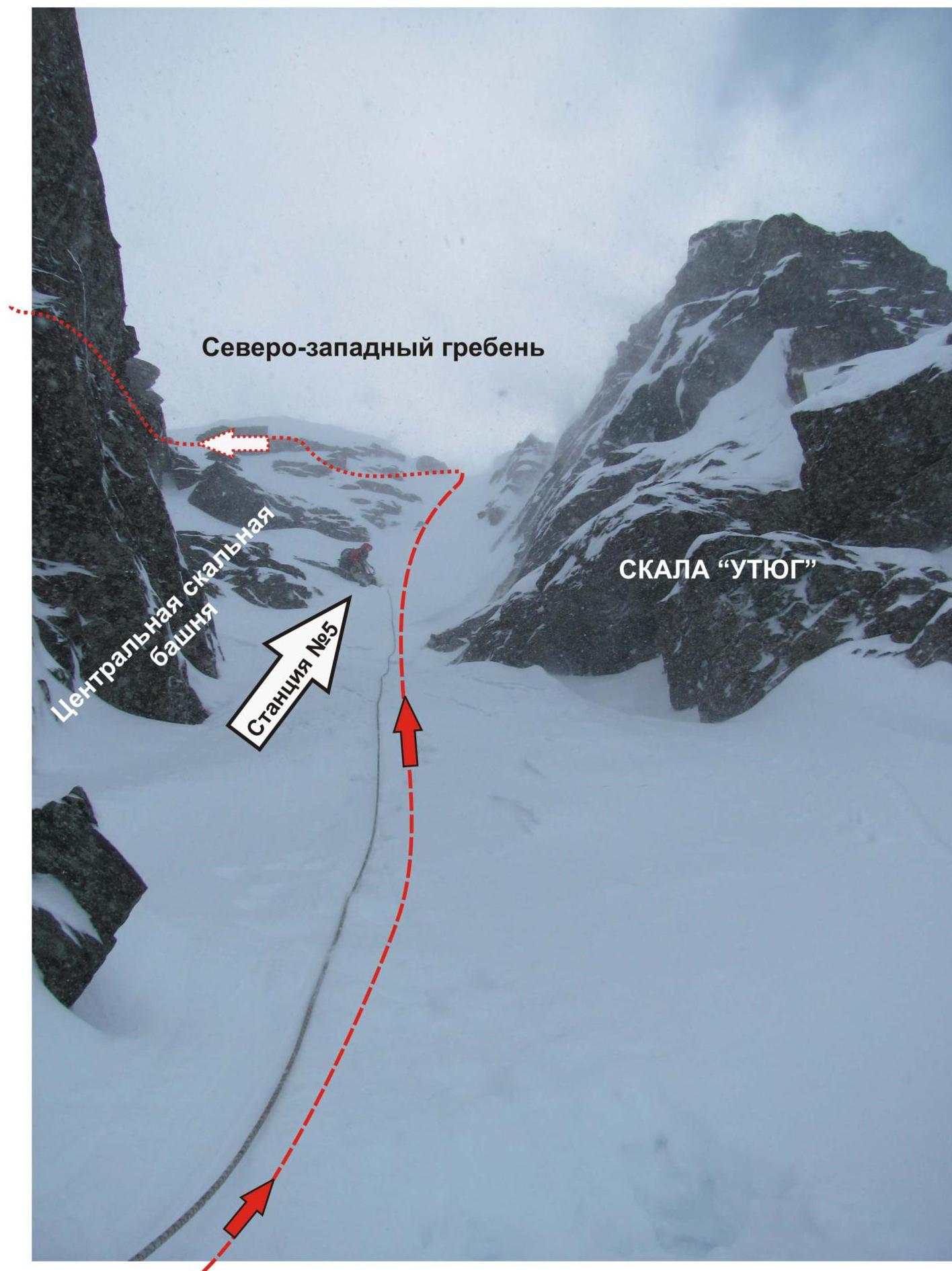
Entrance to the most complex (key) part of the route — the second couloir.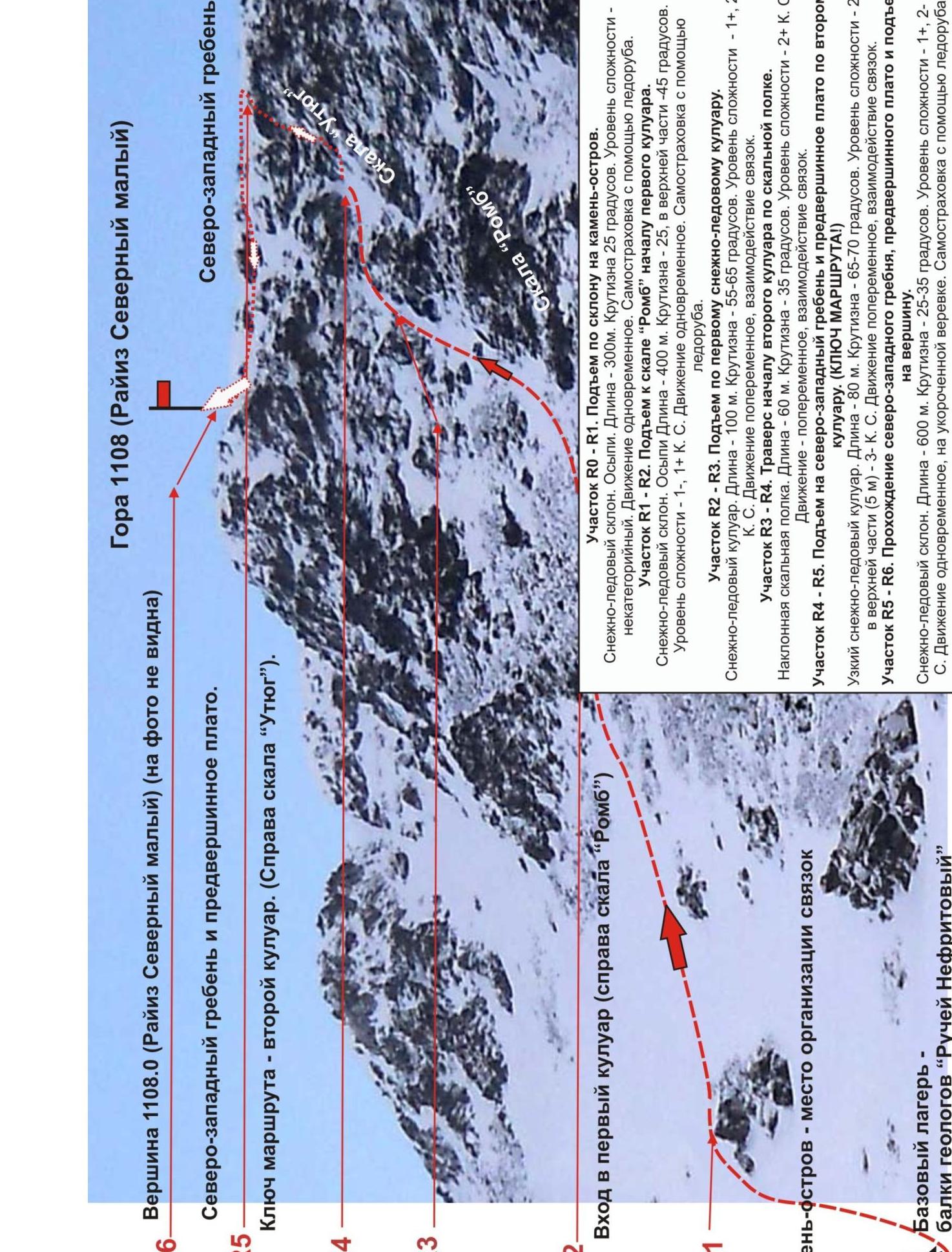
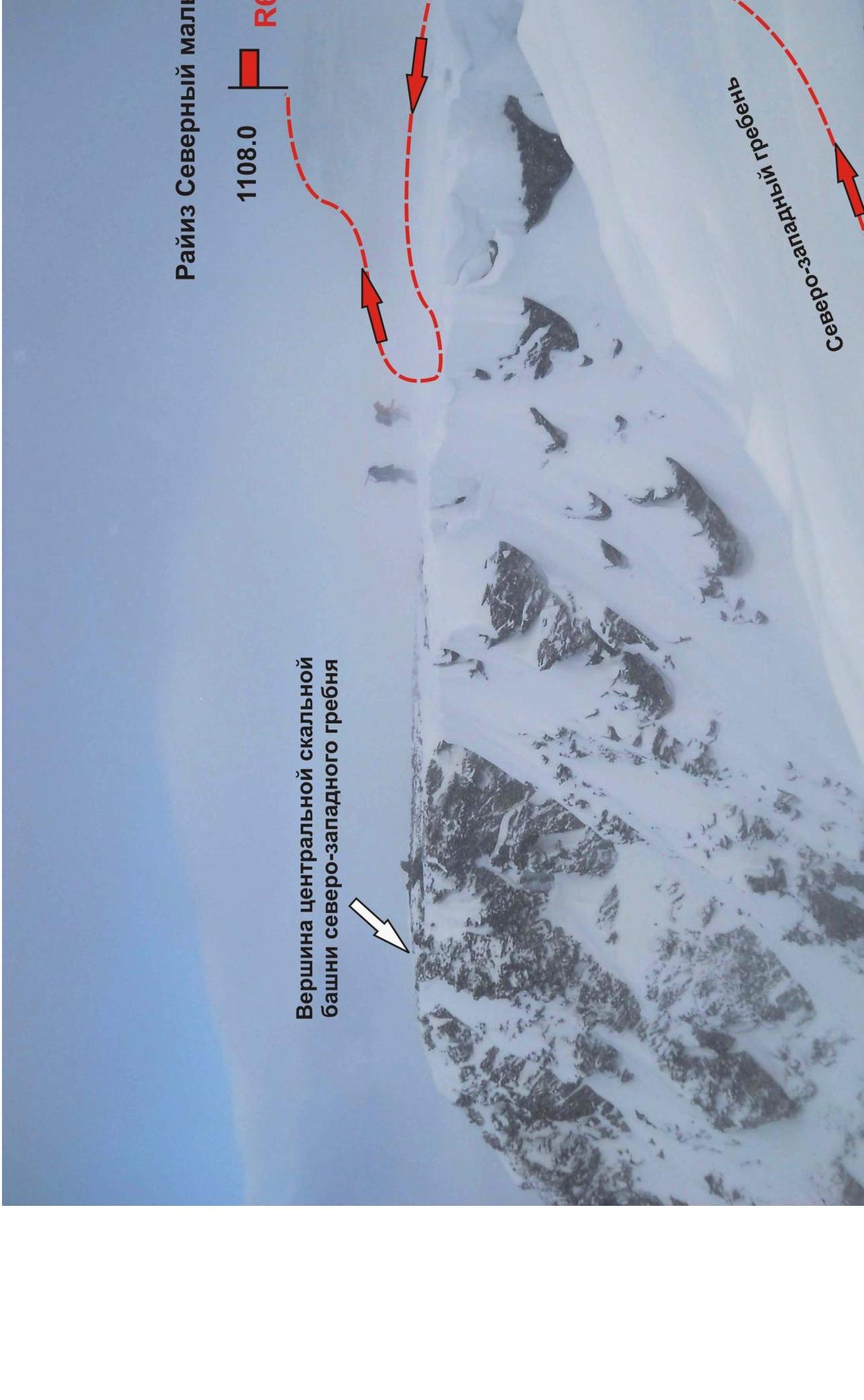
Mountain 1108 (Rai-Iz North Small) Northwestern ridge and pre-summit plateau. The key to the route — the second couloir. (To the right is the «Iron» rock). R5–R4–R3–R2–R1–R0–R5–R2
Entrance to the first couloir (to the right is the «Rhombus» rock) Northwestern ridge
Snowy-icy slope. Scree. Length — 300 m. Steepness 25°. Level of difficulty — non-categorical. Movement is simultaneous. Self-belaying with an ice axe.
Section R1–R2. Ascent to the «Rhombus» rock — the beginning of the first couloir.
Snowy-icy slope. Scree. Length — 400 m. Steepness — 25, in the upper part — 45 degrees. Level of difficulty — 1–, 1+ category of difficulty. Movement is simultaneous. Self-belaying with an ice axe.
Section R2–R3. Ascent along the first snowy-icy couloir.
Snowy-icy couloir. Length — 100 m. Steepness — 55–65 degrees. Level of difficulty — 1+, 2– category of difficulty. Movement is alternating, interaction of rope teams.
Section R3–R4. Traverse — to the beginning of the second couloir along a rocky shelf.
- Length — 60 m
- Steepness — 35 degrees
- Level of difficulty — 2B category of difficulty.
- Movement — alternating, interaction of rope teams
Section R4–R5. Ascent to the northwestern ridge and pre-summit plateau along the second couloir. (KEY TO THE ROUTE!) Narrow snowy-icy couloir.
- Length — 80 m
- Steepness — 65–70 degrees
- Level of difficulty — 2B, in the upper part (5 m) — 3A category of difficulty.
- Movement — alternating, interaction of rope teams
Section R5–R6. Passage along the northwestern ridge, pre-summit plateau, and ascent to the summit. Snowy-icy slope.
- Length — 600 m
- Steepness — 25–35 degrees
- Level of difficulty — 1B, 2A category of difficulty.
- Movement — simultaneous, on a shortened rope
- Self-belaying — with an ice axe
Polar Urals. Rai-Iz mountain massif. Rai-Iz mountain. Summit — 1108.0 m (Rai-Iz North Small). Route — along the northern rocky slope of the northwestern ridge («Two couloirs») 2A category of difficulty. (winter).
Rai-Iz North Small
Polar Urals. Rai-Iz mountain massif. Rai-Iz mountain. Summit — 1108.0 m (Rai-Iz North Small). Route — along the northern rocky slope of the northwestern ridge («Two couloirs») 2A category of difficulty. (winter).