
Peak Pendirmapэ (1221 m)
Route: via the Eastern ridge
Category of difficulty — 2A (winter)
Leader: Sergey Valentinovich Seryakov
Northern part of the Polar Urals (Transpolar Urals), Maly Paipudynsky mountain range
Section in the KMGV — 8.3.
E-mail — mrZHUR1958@MAIL.RU
Report
On the first ascent of the mountaineering route: To the peak Pendirmapэ 2A category of difficulty (winter). At the year-round alpine event Cup of NP "Club of Northern Travels "Sauk-Pai" (Class "First ascents") 2014
Region: Ural Federal District of the Russian Federation (UFD), Yamalo-Nenets Autonomous Okrug of Tyumen Oblast. Mountain country: Northern part of the Polar Urals (Transpolar Urals) Valley: valley of the river Malaya Paipudyna Ridge: Maly Paipudynsky Peak: Pendirmapэ (1221) Route: via the Eastern ridge Prepared by: S.V. Seryakov, S.V. Zhuravlev. July 2014.
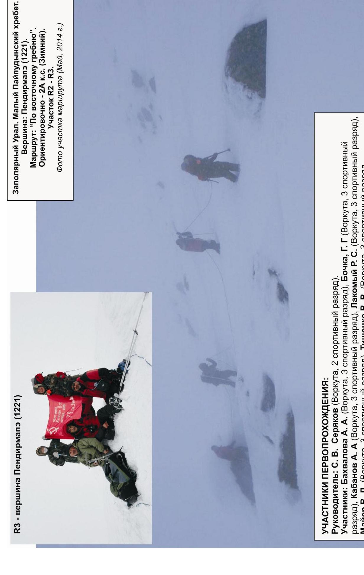
Transpolar Urals. Maly Paipudynsky ridge. Peak: Pendirmapэ (1221). Route "via the Eastern ridge". Approximately: 2A category of difficulty (winter).
Photo of the peak from the southeast (Maŵ, 2014)
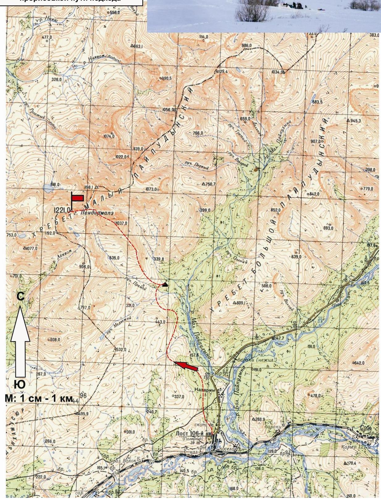
Fragment of a kilometer map, with a drawing of the approach path
Passport
- Number of the section according to KMGV — 2010 — 8.3.
Northern part of the Polar Urals (Transpolar Urals), Maly Paipudynsky ridge.
- Name of the peak: Pendirmapэ
- Height: 1221 m
- Route: via the eastern ridge
- Category of difficulty: 2A
- Character of the route — winter.
- Height difference of the route: 670 m
- Length of the route: 3250 m
- Length of sections of the highest category of difficulty:
1 cat. diff. — 1 section — 1400 m, 2 cat. diff. — 2 sections — 1850 m, 3 cat. diff. — 0 sections — 0 m, 4 cat. diff. — 0 sections — 0 m, 5 cat. diff. — 0 sections — 0 m, 6 cat. diff. — 0 sections — 0 m.
- Average steepness: — 30 degrees.
- Used pitons:
Used in total on the route:
- rock pitons — 0 pcs
- chocks — 0 pcs
- stationary pitons — 0
- ITO — 0
- removable pitons — 0.
Left "pitons" on the route: total — 0 pcs; including stationary — 0.
- Exit to the route — 7:00, May 9, 2014.
Ascent to the peak (Pendirmapэ) — 13:00, May 9, 2014. Return to the base camp — 16:00, May 9, 2014.
- Team's walking hours: — 7 hours.
- Leader: Sergey Valentinovich Seryakov (2nd sports category, Vorkuta). Participants: Alla Alexandrovna Bakhvalova (Vorkuta, 3rd sports category), Grigory Grigoryevich Bochkа (Vorkuta, 3rd sports category), Alexander Anatolyevich Kabanov (Vorkuta, 3rd sports category), Roman Sergeyevich Lakomy (Vorkuta, 3rd sports category), Viktor Ludwigovich Mayer (Vorkuta, 3rd sports category), Vladimir Viktorovich Tishchenko (Vorkuta, 3rd sports category).
- Coach: Sergey Vasilievich Zhuravlev, title — CMS, instructor-methodologist of the 1st category.
Approach from the 110 km halt (former settlement Polar) — 3.4 hours on skis
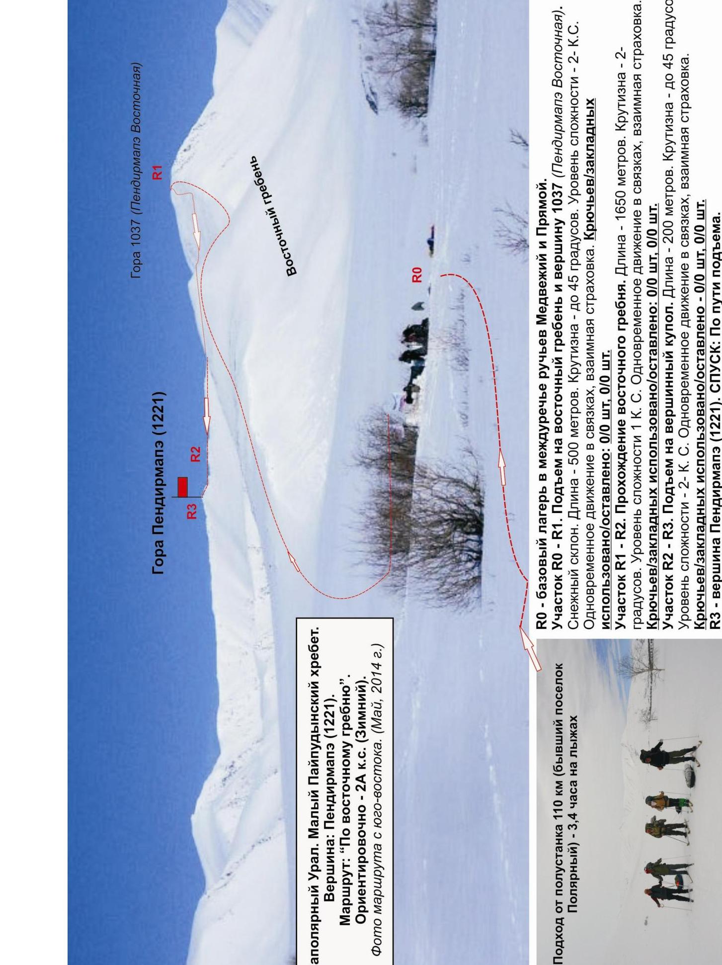
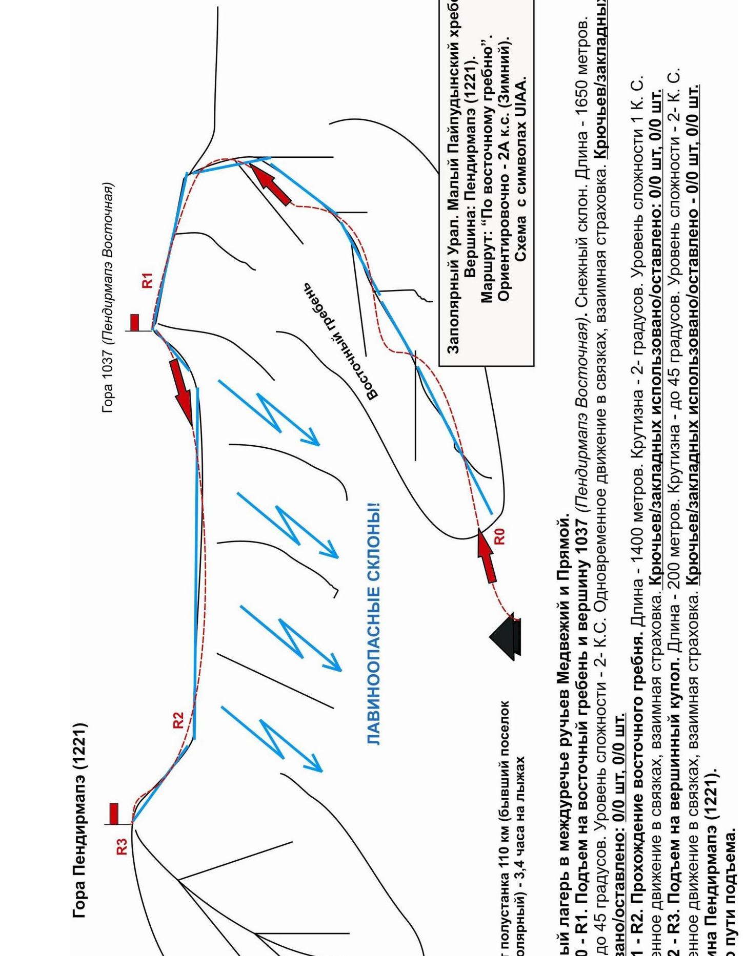
R0 — base camp in the interfluve of the streams Medvezhiy and Pryamoy.
Section R0–R1.
- Ascent to the eastern ridge and peak 1037 (Pendirmapэ Eastern). Snow slope.
- Length — 500 m.
- Steepness — up to 45°.
- Level of difficulty — 2B.
- Simultaneous movement in rope teams, mutual insurance.
- Pitons/chocks used/left: 0/0 pcs., 0/0 pcs.
Section R1–R2.
- Passage of the eastern ridge.
- Length — 1650 m.
- Steepness — 2°.
- Level of difficulty — 1B.
- Simultaneous movement in rope teams, mutual insurance.
- Pitons/chocks used/left: 0/0 pcs., 0/0 pcs.
Section R2–R3.
- Ascent to the summit dome.
- Length — 200 m.
- Steepness — up to 45°.
- Level of difficulty — 2B, cat. diff.
- Simultaneous movement in rope teams, mutual insurance.
- Pitons/chocks used/left — 0/0 pcs, 0/0 pcs.
R3 — peak Pendirmapэ (1221 m).
DESCENT: Via the ascent route.
Description of the peak
Peak Pendirmapэ — the highest mountain of the Maly Pай-Pудынский ridge. Located in the main watershed ridge of the northern part of the Polar Urals (Transpolar Urals), on the border of Europe and Asia, the Komi Republic (North-Western Federal District of the Russian Federation) and the Yamalo-Nenets Autonomous Okrug (YNAO) of Tyumen Oblast (Ural Federal District of the Russian Federation). Height — 1221 m above sea level. Official name. Known since the 18th century, plotted on kilometer maps of the General Staff of the Russian Federation. Translated from the Nenets language means — "Mountain that attracts heavenly thunder, fire (thunder, lightning)".
Description of the route
Route "Via the Eastern ridge" — a typical training and educational combined route of 2A category of difficulty (snow and ice), with a full set of snow obstacles corresponding to routes of this level.
Passing this route has not only aesthetic but also practical sports significance, as it allows to work out techniques within the ascent:
- insurance,
- self-insurance on snow relief.
The route is logical, long, requiring preliminary preparation.
Equipment
For the ascent as part of a training and sports group of 6 people (5 participants + instructor) on the route, the following special equipment is necessary:
Personal (standard, including):
- crampons
- ice axe
- avalanche cord (beeper)
Group:
- main rope 10 mm × 50 m — 3 pcs.
- avalanche shovels — 2 pcs.
Approach
The ascent is made from the "Interfluve of the streams Medvezhiy and Pryamoy" halt.
Approach to the halt:
- The approach is made on skis (snowshoes are allowed).
- From the 110 km halt (former settlement Polar) go along the dirt road to the destroyed bridge across the river Malaya Paipudyna.
- Then along the right bank of the river ascend to the upper reaches of the river Malaya Paipudyna.
- After crossing the stream Medvezhiy (open water is possible) on the high left bank there are convenient places for organizing a bivouac.
Features of the bivouac:
- Bivouac "Interfluve of the streams Medvezhiy and Pryamoy" is located in the tundra zone, gas burners are necessary.
- Telephone connection is absent.
- Communication via VHF radio stations is problematic.
Time of approach:
- From the 110 km halt to the bivouac takes 3–4 hours.
- From the bivouac "Interfluve of the streams Medvezhiy and Pryamoy" to the start of the route — one and a half to two hours.
Technical part
The beginning of the route — a snow slope of the eastern ridge. There is a convenient place for organizing rope teams — a wind-protected niche under the rock. Crampons on the route are mandatory!
In May, the present crust is not inferior in density to multi-year firn. The slope is potentially avalanche-prone, especially with fresh snowfall, so it is recommended to ascend the slope "head-on" to the exit to the eastern ridge of peak 1037 (Pendirmapэ Eastern).
Climb along the ridge to peak 1037 (Pendirmapэ Eastern). From peak 1037 (Pendirmapэ Eastern) you should examine the safest path along the ridge, as there are seasonal, overhanging cornices.
Then move along the snow-covered ridge, which to the north (along the way — to the right) of the peak adjoins the main watershed ridge. From the junction along the main watershed ridge go to the pre-summit plateau and along the snow-covered plateau go south (to the left along the way), in the direction of the pronounced rock remnant.
The ridge to the peak narrows to 1.5–2 m. The use of crampons on the pre-summit plateau and the main watershed ridge depends on the density of the snow.
The route is equivalent in difficulty, there is no pronounced key section.
Peak Pendirmapэ (1221) — a pronounced rock remnant on the summit plateau in the northern part, where the plateau narrows to a narrow ridge. Tour under the rock remnant.
Descent from the peak is carried out along the ascent route.
Peak 1037 (Pendirmapэ Eastern)
Northern part of the Polar Urals (Transpolar Urals). Maly Paipudynsky ridge. Peak: Pendirmapэ (1221). Route: "Via the Eastern ridge". 2A (winter) (approximately)
(table of natural obstacles of the route)
| № section | Length | Steepness | Character of relief | – | --------------------- |
|---|---|---|---|---|---|
| APPROACH | From the base camp in the interfluve of the streams Medvezhiy and Pryamoy about four kilometers and takes 1.5 hours along the mountain tundra and snow slopes. Approach on skis (snowshoes). | ||||
| R0 — Base of the eastern ridge | Convenient place for organizing rope teams | ||||
| R0–R1. Ascent along the eastern slope of the eastern ridge to peak 1037 (Pendirmapэ Eastern) | 1650 | up to 45 | Snow slope. (Avalanche danger! Movement only "head-on") | 2- | 0/0 |
| R1–R2. Passage of the eastern ridge | 1400 | 20 | Snow ridge | 1 | 0/0 |
| R2–R3. Ascent to the summit dome | 200 | up to 45 | Snow-covered scree ridge | 2- | 0/0 |
| R6 — peak Pendirmapэ (1221 m). | Rock remnant on the summit plateau in the northern part, where the plateau narrows to a ridge. Tour under the rock remnant. | ||||
| DESCENT | Along the eastern ridge (along the ascent route). |
Total
Length of the route — 3250 m. Average steepness — 30°. Character of relief — snow and ice. Technical sections:
- cat. diff. 1B — 1 section — 1400 m
- cat. diff. 2B — 2 sections — 1850 m
Used pitons and chocks: 0/0. Left pitons and chocks: 0/0.
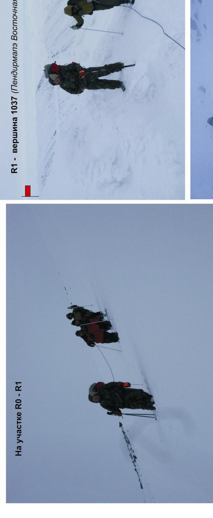
R1 — peak 1037 (Pendirmapэ Eastern)
- A. A. Bakhvalova (Vorkuta, 3rd sports category)
- G. G. Bochkа (Vorkuta, 3rd sports category)
- A. A. Kabanov (Vorkuta, 3rd sports category)
- R. S. Lakomy (Vorkuta, 3rd sports category)
- V. L. Mayer (Vorkuta, 3rd sports category)
- V. V. Tishchenko (Vorkuta, 3rd sports category)
Footnotes
-
Participants of the first ascent: Leader: S. V. Seryakov (Vorkuta, 2nd sports category). Participants: ↩