
Open XIX EAAC Alpine Championship
High-Altitude Technical Class
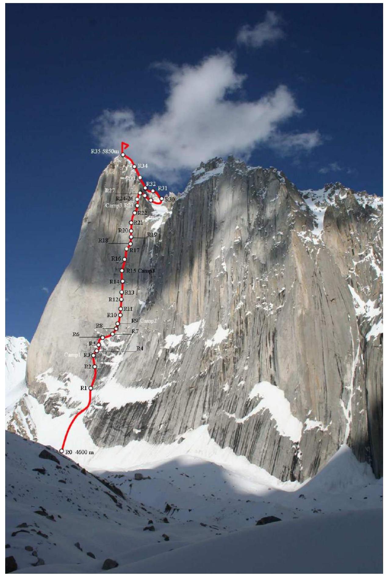
Report on the ascent of the national team of FAiS, Kiev (Ukraine) to the summit of Amin Brakk (5850 m) via the Western wall. "Czech Express" route. Category 6B. Karakoram. Pakistan. July 2010.
CIS Championship in the high-altitude technical class.
Team coach: Lavrenko A.V.
Team leader: Kopteva M.V.
Ascent Passport
- Karakoram, Nangma Region
- Amin Brakk peak via the Northwest wall. "Czech Express" route
- Estimated category: 6B (7b+; A3+)
- Route type: combined
- Height difference: 1250 m
- Route length: 2140 m.
Section lengths:
- Category V: 250 m
- Category VI: 1240 m
- Average steepness: wall section: 86° entire route: 63°
- Number of pitons on the route: rock pitons: 146 protection gear: 373 bolt hangers (station spits): 41 ice screws: 8
- Team's total hours: 230 h, 17 days (+1 day descent)
Overnights:
- 1st–5th nights on a platform under a cornice
- 6th–9th nights on a platform on the "plinth"
- 10th–14th nights on a platform under the first cornice
- 15th night on a platform in the "chimney"
- 16th night: descent from the summit to the platform in the "chimney"
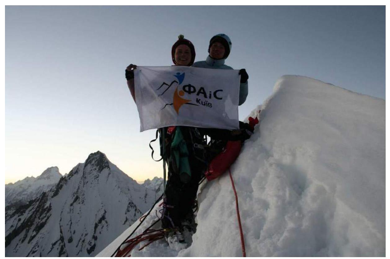
- Team leader: Kopteva Marina Vladimirovna — Master of Sports Participant: Yasinskaya Anna Leonidovna — Candidate for Master of Sports, Chibitok Galina Vladimirovna — Master of Sports Coach: Lavrenko Alexander Vadimovich — Master of Sports
- Departure: 6:00, July 2, 2010 Summit: 20:00, July 17, 2010 Return to Base Camp: 22:00, July 19, 2010
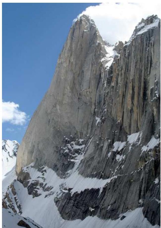
Amin Brakk 5850 m
Amin Brakk peak is located in the Karakoram range. Nangma valley, Konde gorge. Access to this region is via Skardu: 7 hours by jeep from Skardu to Konde village. Then a 2-day hike to the base camp, which is located on the moraine of the glacier under the Western wall of Amin Brakk, at an altitude of 4300 m. From the base camp to the start of the route: 1.5 hours on foot across the moraine and glacier.
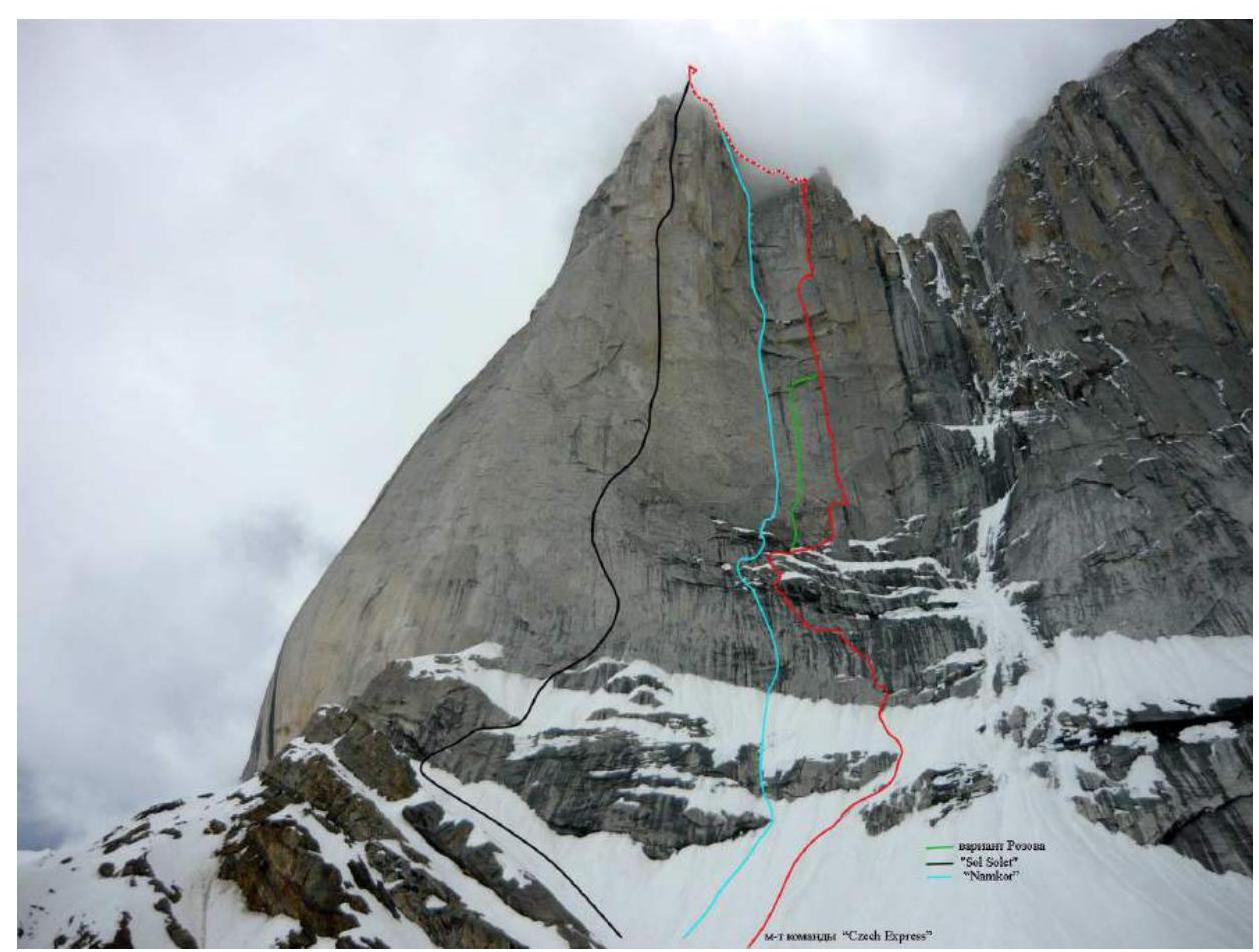
The Western wall of Amin Brakk was first discovered by Spanish climbers in 1995 during an ascent of Nawaz Brakk peak via the northwest wall. In 1996, Jon Lazkano, Aldolfo Madinabeita, and Jose Tamayo returned to the area and attempted to climb Amin Brakk via the Western wall but were forced to retreat due to bad weather. In 1998, South Korean climbers also attempted to continue the Spanish route but were unsuccessful.
In July 1999, Czech climbers Marek Holecek, Filip Silhan, and David Stastny continued the line started by the Spanish in 1996 and summited Amin Brakk. The route was named "Czech Express".
In August 1999, a team of Spanish climbers led by Silvii Vidal established the "Sol Solet" route, which was nominated for the "Golden Ice Axe". 140 meters of this route have a category of A5.
In 2000, a Spanish duo climbed one of the most challenging routes on the Western wall of Amin Brakk, "Namkor", which received several international awards.
In 2004, Valery Rozov's team successfully completed a variation of the "Czech Express" route and performed an unprecedented BASE jump.
The wall is composed of granite. There are many blind cracks and flaking slabs. The Western wall is potentially hazardous in the afternoon due to rockfall and icefall.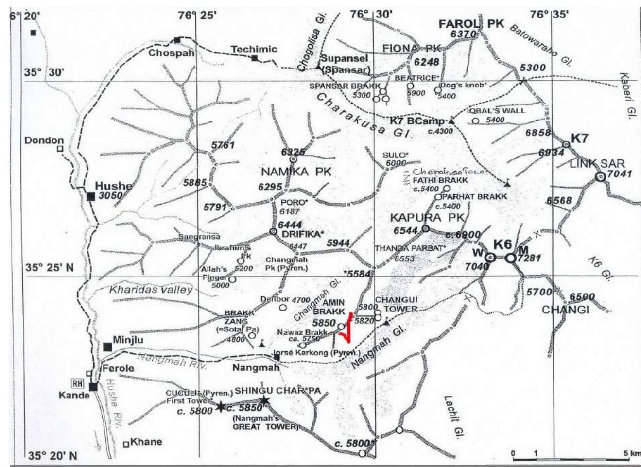
Route Description by Sections
R0–R1 Snow slope (50°, 200 m). Simultaneous protection. After 12:00, exposed to rockfall and icefall. Category 3.
R1–R2 Climbing an internal corner intersected by two cornices with overhangs up to 1 m. Station on a ledge. One spit. 60 m. 6, A2.
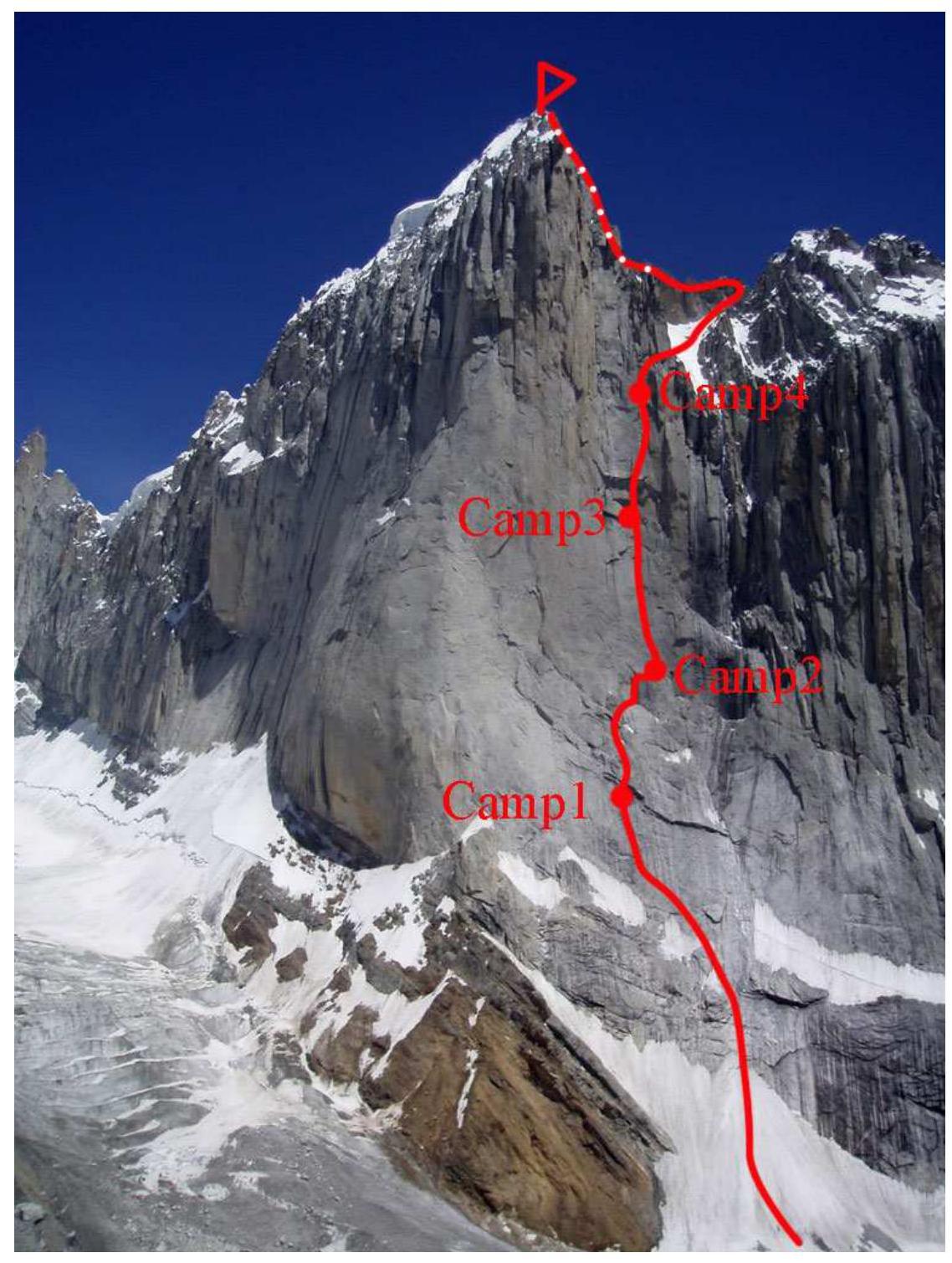
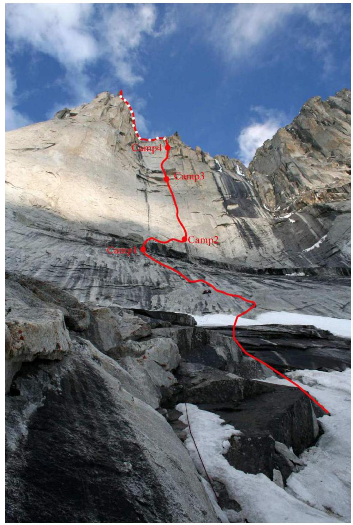
R2–R3 Climbing a crack upwards under a cornice. A platform is established under the cornice. Camp1. Two spits. 60 m. 6, A2.
R3–R4 From the station, traverse 10 m to the right under the cornice with overhangs up to 2 m. Then, on aid climbing, move left upwards 12 m and exit beyond the cornice. Station on 3 bolt hangers. 40 m. 6, A3.
R4–R5 From the station, climb left upwards into an internal corner and ascend it, partly free climbing and partly aid climbing, to a hanging overhang (after bad weather, filled with snow and ice!). A spit at the station. 50 m. 6, A2.
R5–R6 From the station, traverse right into an internal corner and ascend it left upwards to a ledge. Station: bolt hanger + 2 spits (without ears). 60 m. 6.
R6–R7 From the station, climb right upwards to a ledge under a cornice. 50 m. 6, A2.
R7–R8 Traverse right through a snowfield to the end of the cornice, to the base of an internal corner, and ascend the corner right upwards. Station on 2 spits. 60 m. 6, A3.
R8–R9 From the station, climb directly upwards on a slab (holes for 10 mm skyhooks) to a bolt hanger. Then, move right to the base of a "plinth". Ascend an internal corner through a hanging section to the top of the "plinth". 60 m. 6, A3. Good bivouac site. Many bolt hangers. Can stand on feet. Camp2.
R9–R10 From the station (on the right part of the "plinth"), climb directly upwards through a crack to a small ledge. One bolt hanger. Convenient for a station in Camp2.
R10–R11 From the ledge, climb directly upwards through a crack to a hanging station. 2 spits. 30 m. 6, A3.
R11–R12 Climb the same crack (partly blind) on aid climbing to the next hanging station. 60 m. 6, A3.
R12–R13 From the station, climb 10 m through the crack to a bolt hanger, then enter an internal corner. Ascend the corner to a cornice. Exit beyond the cornice to a ledge (be cautious: icicles and ice!). Station on spits. 60 m. 6, A3.
R13–R14 From the station, climb slightly left upwards through a crack to a more gentle section. 40 m. 6, A2.
R14–R15 From the station, climb directly upwards through a crack to a cornice (the first of three with an overhang of 3 m). Station on 3 bolt hangers. Camp3 here. 20 m. 6, A3.
R15–R16 The cornice is climbed directly head-on through a crack. Beyond the overhang: a bolt hanger. Then, ascend the crack to a second cornice with an overhang of up to 3 m. It is also climbed head-on through a crack. Beyond the cornice: a hanging station on 2 spits. 50 m. 6, A3.
R16–R17 From the station, climb 2 m upwards and then left into an internal corner. Ascend the corner to the base of a crack that cuts through the third cornice with an overhang of up to 7 m. Station immediately beyond the cornice on a ledge. 30 m. 6, A3+.
R17–R18 From the station, ascend a crack on aid climbing to a ledge. 2 bolt hangers. 60 m. 6, A2.
R18–R19 From the station, climb right upwards through an internal corner to a bolt hanger and then enter the base of a chimney. 50 m. 6, A2.
R19–R20 Ascend the chimney directly upwards to a small cornice (climbed head-on) and then exit to a ledge. 2 bolt hangers. 50 m. 6, A2.
R20–R21 From the station, climb directly upwards through a crack to a ledge. 30 m. 6, A2.
R21–R22 Then, ascend a crack to a hanging section and exit to a ledge. 50 m. 6, A2.
R22–R23 From the station, climb left upwards through a system of cracks to a more gentle section (under a hanging overhang). 60 m. 6, A2. Camp4.
R23–R24 Ascend a crack through a hanging overhang to a ledge. Station on personal gear. 30 m. 6, A3.
R24–R25 Then, ascend an internal corner to an overhanging wall. Climb it directly upwards to a small cornice. Station in a small chimney. 50 m. 6, A2.
R25–R26 Exit beyond the small cornice to a more gentle section and approach the next overhanging wall with a system of cracks. Ascend it to a ledge. 2 bolt hangers. 60 m. 6, A2.
R26–R27 Then, climb directly upwards through a crack to a more gentle section. 30 m. 6, A1.
End of the wall section.
R27–R28 From the station, traverse right 7–10 m. Then, climb right upwards to a firn slope. Ascend it left upwards to a rock spur. Station there (spit + personal gear). 60 m. 5.
R28–R29 From the station, traverse right horizontally to a rock island. 120 m. 4.
R29–R30 Climb a firn slope with a steepness of up to 50° towards a saddle on the south ridge. 250 m. Category 4.
R30–R31 Ascend the ridge (20 m left of the saddle) to a rock outcrop. Enter the base of a chimney and climb it to a bolt hanger (station). Climbing in crampons. 60 m. 5.
R31–R32 From the station, descend left beyond a ridge and ascend a snow couloir to a snow slope (snow above waist level). Climb the slope (be cautious! Cornices) to a rock island. Station. 70 m. 5.
R32–R33 Bypass the island on the right and ascend the ridge to a right rock outcrop. Station. 30 m. 4.
R33–R34 Then, climb directly upwards on a snow slope to a base of a summit tower. One bolt hanger. 50 m. 4.
R34–R35 From the station, traverse right 20 m. Enter a snow-ice couloir. Ascend it to a saddle between the summit rocks. Right: a loop and exit to the summit. 60 m. 5.
Tactical Plan
From June 28 to 30, the team transported loads to the base of the wall (about 150 kg).
On June 30 and July 1, the team decided to take a break and rest before the ascent.
On July 2, at 5:00, the team started on the route. By 12:00, they had climbed 300 m of snow slope and began working on the rock section. At 20:00, they established Camp1 under a large cornice, which protected them from precipitation, rockfall, and avalanches (on the diagram: R3). The weather was sunny.
On July 3, the weather deteriorated sharply: wet snow, hail. They managed to climb one and a half ropes. The terrain was poor. After lunch, it was impossible to work beyond the cornice due to the risk of icefall and rockfall.
On July 4, the weather did not improve. Snow. They managed to pitch another one and a half ropes. The team reached R6. The terrain became richer. Visible signs of Valery Rozov's team's passage 50–70 m to the right of the route.
On July 5, the weather improved. Overcast, but no precipitation. They managed to pitch two more ropes. The wall and hanging cornices and icicles were clearly visible. One and a half ropes to the supposed Camp2. Due to the risk of icefall, the team descended to the platform at 13:00 (R8).
On July 6, they pitched all the ropes to R9 (an excellent site for Camp2), a huge "plinth". Many signs of Czech and Korean expeditions: bolt hangers, rope remnants, gear, and even food remains. The R8–R9 section is one of the most challenging on the route. The "plinth" was overcome. Ahead lay over 500 m of steep wall. The weather was overcast.
On July 7, sunny weather. The team relocated the camp, fetched 60 liters of water (under the cornice where the platform was), and removed ropes. By 19:00, Camp2 was established at R9.
On July 8, the weather was excellent. The terrain changed significantly. Absolute steepness. A uniform crack stretched for hundreds of meters: partly blind, partly opening outwards, filled with moss. It was necessary to clean the intended station site with a hammer before setting up protection. They processed 100 m (R11).
On July 9, sunny. Continued work on the route. The terrain remained unchanged. Blind aid climbing. Worked directly under giant cornices with hanging icicles. Sometimes ice fell. Processed up to R13.
On July 10, sunny. The terrain remained the same. Towards the end of the day, they approached the first of a series of cornices. Visible signs of previous expeditions: many bolt hangers, rope remnants, a sitting platform. Established a site for Camp3.
On July 11, sunny. The team relocated the camp and removed ropes. The Kopteva–Yasinskaya pair managed to pitch one rope to R14 (the second of three cornices) and approached a huge cornice with an overhang of 7 m.
On July 12, the weather began to deteriorate. Became overcast. After lunch, it snowed. Managed to pitch the large cornice and reach R17.
On July 13, the weather worsened: snow with hail. Snow and water flowed down the wall. Managed to process about 100 m (R19).
On July 15, the weather was bad, but the team managed to pitch all the ropes and reach the intended bivouac site (R23).
On July 16, the weather improved. Decided to leave some gear, food, and water at Camp3 and ascend to R23 with a light pack. On the same day, they pitched ropes to R27.
On July 17, at 2:00, the team departed from the platform and began moving towards the summit. Reaching the end of the previously fixed ropes, they took 2 ropes, ice gear, and camera equipment and continued towards the saddle on the south ridge of Amin Brakk. By 10:00, the team was on the ridge. Movement along the ridge was significantly hindered by deep snow, snow cornices, and icy rocks. They reached the summit at 20:00. Decided to begin descent due to good weather and visibility (full moon), rather than bivouacking at an altitude of 5850 m near the summit. The team descended to the platform by 6:00 on July 18, 2010.
On July 19, 2010, at 3:00, they began their descent and by 22:00 were at the base of the wall.
Camp1
 □
□
Digitized by Google
| Rock Pitons | Protection Gear | Bolt Hangers | UIAA Symbol Route Diagram | Length | Category | Steepness |
|---|---|---|---|---|---|---|
| 10 | 12 | 4 | Camp2 R9 | 60 m | 6, A3 | 90° |
| 12 | 8 | 2 | 60 m | 6, A3 | 80–85° | |
| 8 | 18 | 0 | 50 m | 6, A2 | 80–85° | |
| 4 | 17 | 2 | 60 m | 6 | 80–85° | |
| 4 | 12 | 1 | 50 m | 6, A2 | 80–85° | |
| 12 | 6 | 3 | 40 m | 6, A3 | 80–85° | |
| 6 | 12 | 2 | 60 m | 6, A2 | 80–85° | |
| 8 | 15 | 2 | 60 m | 6, A2 | 75–80° | |
| 0 | 0 | 0 | 200 m | 3 | 50° |
| Rock Pitons | Protection Gear | Bolt Hangers | UIAA Symbol Route Diagram | Length | Category | Steepness |
|---|---|---|---|---|---|---|
| 7 | 8 | 1 | 30 m | 6, A3 | 90° | |
| 12 | 14 | 1 | 60 m | 6, A2 | 90° | |
| 6 | 10 | 1 | 50 m | 6, A2 | 90° | |
| 3 | 12 | 1 | 30 m | 6, A2 | 90° | |
| 8 | 10 | 1 | 50 m | 6, A2 | 85° | |
| 3 | 16 | 2 | 50 m | 6, A2 | 85° | |
| 0 | 22 | 1 | 60 m | 6, A2 | 90° | |
| 2 | 10 | 1 | 30 m | 6, A3 | 90° | |
| 4 | 14 | 1 | 50 m | 6, A3 | 90° | |
| 2 | 8 | 1 | 20 m | 6, A3 | 90° | |
| 6 | 9 | 1 | 40 m | 6, A2 | 90° | |
| 3 | 17 | 1 | 60 m | 6, A3 | 90° | |
| 2 | 20 | 2 | 60 m | 6, A3 | 90° | |
| 0 | 12 | 1 | 30 m | 6, A3 | 90° | |
| 6 | 10 | 2 | 40 m | 6, A3 | 90° |
| Rock Pitons | Protection Gear | Bolt Hangers | UIAA Symbol Route Diagram | Length | Category | Steepness |
|---|---|---|---|---|---|---|
| 2 | 1 | 0 | 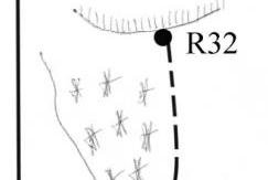 | 70 m | 5 | 50° |
| 1 | 3 | 1 | 60 m | 5 | 85° | |
| 2 | 4 | 0 | 250 m | 4 | 70° | |
| 2 | 3 | 1 | 120 m | 4 | 70° | |
| 0 | 4 | 1 | 60 m | 5 | 70° | |
| 0 | 9 | 1 | 30 m | 6, A1 | 70° | |
| 3 | 17 | 1 | 60 m | 6, A2 | 90° | |
| 8 | 16 | 2 | 50 m | 6, A2 | 90° |
| Ice Screws | Protection Gear | Bolt Hangers | UIAA Symbol Route Diagram | Length | Category | Steepness |
|---|---|---|---|---|---|---|
| 4 | 0 | 0 | 60 m | 5 | 70° | |
| 2 | 1 | 1 | 50 m | 4 | 50° | |
| 2 | 1 | 0 | 30 m | 4 | 50° |
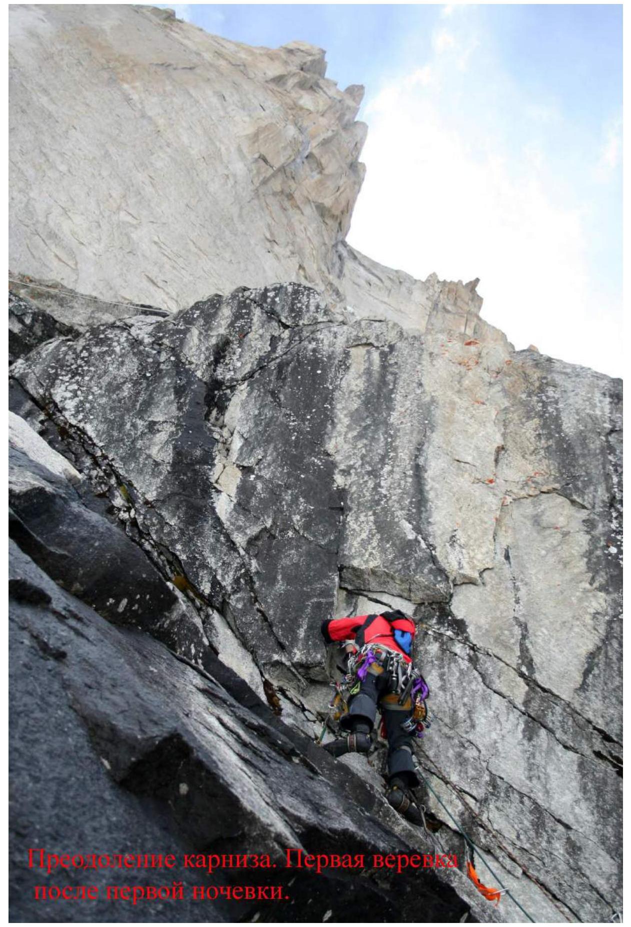 Passing the cornice. First rope after the first night.
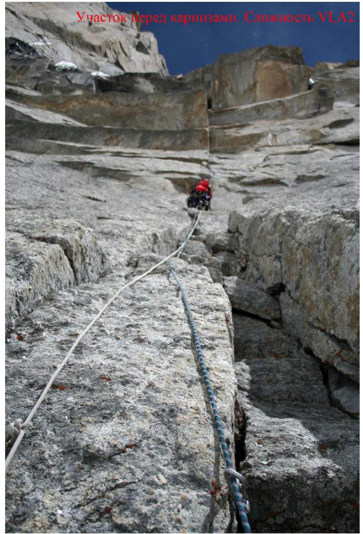 Section before the cornices. Complexity 6, A2.
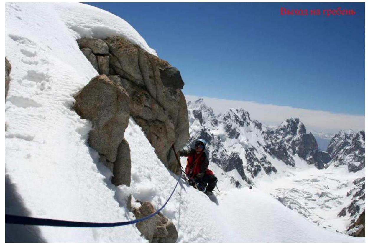 To the ridge.
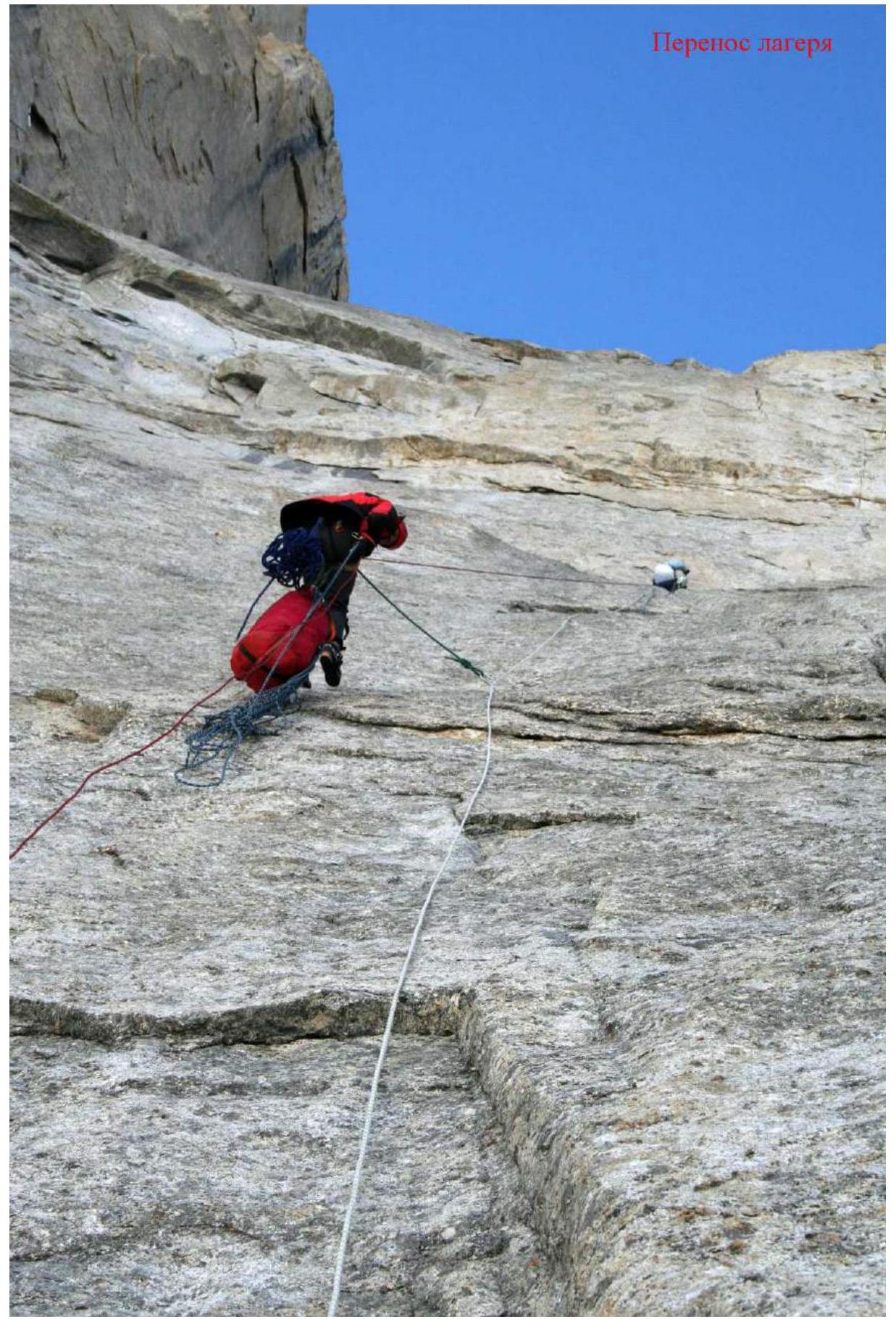 Relocating the camp.
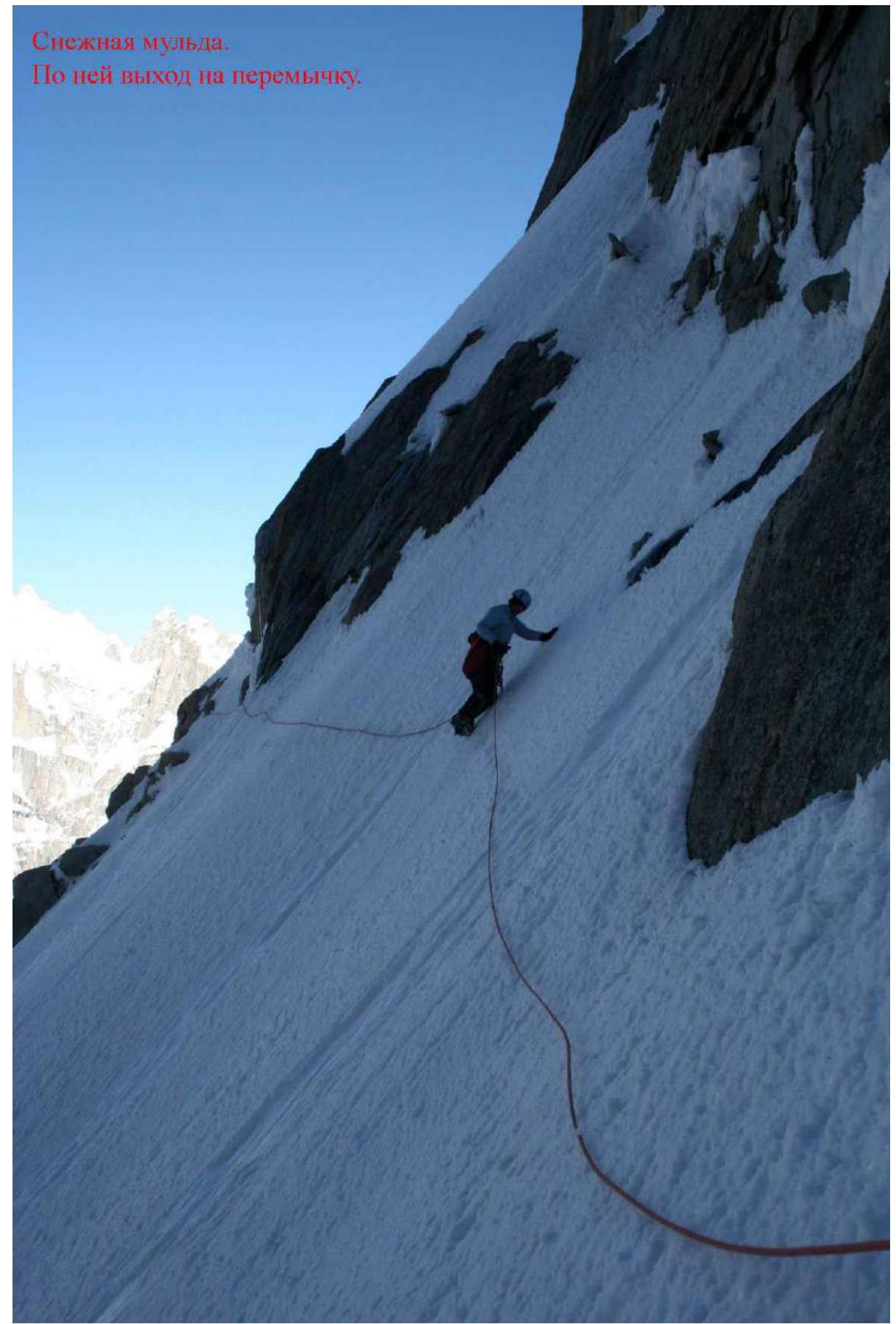 Snowy depression. Exit to the saddle.
Footnotes
-
35°20′ N ↩