
Passport
I. Class of ascents — high-altitude technical 2. Region — Himalayas 3. Peak MAKALU (8463 m) via NW ridge, combined route 4. Estimated category of difficulty — 5B 5. Elevation gain: 2663 m (5800–8463 m), distance — 6200 m Distance of sections with 5th category of difficulty — 900 m Average steepness — 35° 6. Pitons driven: rock 43, chocks 52, ice screws 18, snow stakes 12 7. Travel hours: 29, days — 4 8. Overnights: 1st in Camp II (6500 m), 2nd in Camp III (7500 m), 3rd in Camp IV (7800 m). 9. Leader: PLOTNIKOV Ivan Aleksandrovich, Master of Sports of International Class Climber: KOROTEEV Vladimir Konstantinovich, Master of Sports of International Class 10. Coach: Plotnikov I.A. — Master of Sports of International Class II. Departure to the route: May 16, 1996 Summit: May 19, 1996 at 14:00 Nepal time. Return: May 21, 1996 12. Organization: Altai Krai Sports Committee.
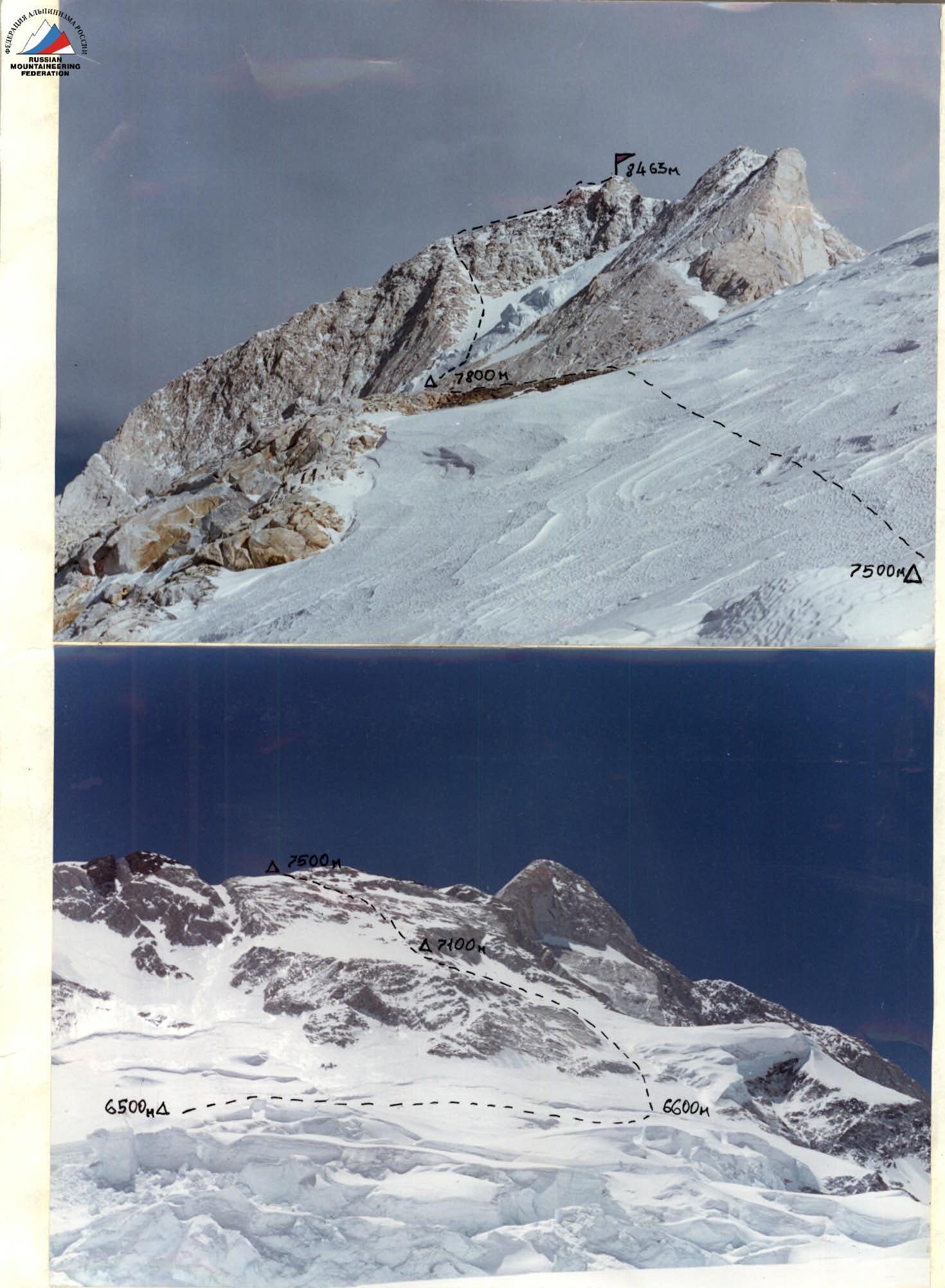
PHOTO #1, #2. Northwest ridge of MAKALU peak (8463 m). Photos by V. Koroteev from 6200 m and 7500 m. Camera — "Kodak".
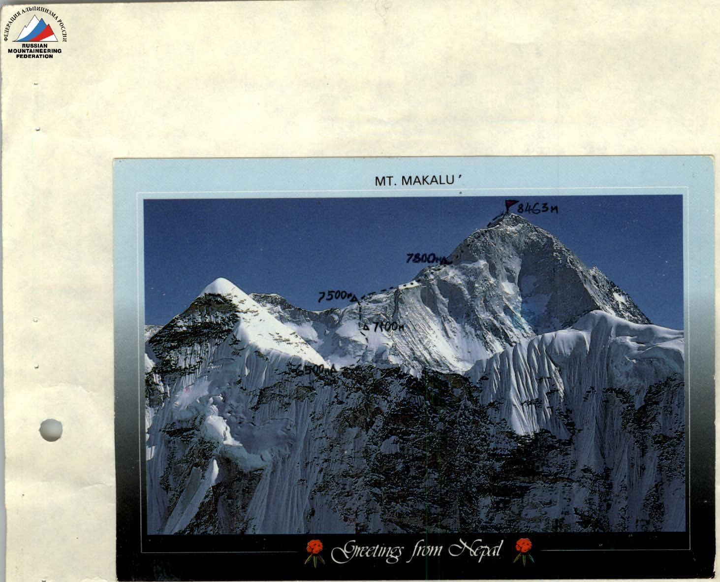
PHOTO #3. Profile of the northwest ridge on the right. Photograph by Gyanendra Das (Nepal). The northwest ridge to MAKALU peak (8463 m) is quite complex both technically and physically. This is a very labor-intensive and psychologically tense route. In addition, the expedition set itself the challenging task of ascending without oxygen.
From mountaineering literature, it is known that many expeditions traversed the lower part of the northwest ridge via various variations. Here, the weather and the state of the route made their corrections.
Our expedition, starting from 6000 m, worked on the left variant (bypassing the icefall via the firn plateau). This was due to the presence of hazardous seracs in the icefall. After reaching the upper tier of ice fractures (6500 m), Camp II was established, and the exit to the main ridge to the right of the Makalu La pass (7410 m) was scouted and processed. There, at 7500 m, Camp III was established.
The option of reaching the pass via the ice couloir was not chosen due to constant rockfall from the couloir's rocky sides. Our expedition worked out a technically more complex but safer variant to reach the main ridge on this section. A total of about 1200 m of rope was fixed on it.
Sect. 5800–6500 m. Camp I is a starting camp for many expeditions. Comfortable and cozy bivouacs, protected from the wind. Passage through the icefall to the firn plateau; upon exit, one rope is fixed on the ice wall (6000 m). Then 2–3 hours across the plateau cut by crevasses. From the plateau, exit to the upper tier via a steep ice-firn slope; Camp II was established here (6500 m).
Sect. 6500–7500 m. This is the most technically complex section. Initially, movement across the upper tier for 1.5–2 hours to the bergschrund (6600 m), then up an ice slope with a steepness of up to 45°. Organization of fixed ropes. During processing, this section was traversed with the establishment of an intermediate camp at 7100 m. Above — movement across snow-covered and icy rocks of 4th-5th category of difficulty. Series of walls and ledges, with steepness on individual sections up to 55–60°. On the ridge — convenient firn areas for tents, but constantly strong winds blow both from the Tibetan and Nepalese sides. After acclimatization, the time taken to traverse this section is 8–9 hours.
Sect. 7500–8463 m. Firn slopes with a steepness of 20–30°, then a traverse across rocks — bypassing a large gendarme on the left. Before reaching Camp IV at 7800 m — an extended ice slope with a steepness of up to 40°, and then — exit to the icefall. The icefall is traversed via an oblique traverse under the base of the couloir (8000 m). The ice is very hard and frozen. Organization of fixed ropes. The start of the couloir is an ice-firn slope, then — snow-covered and icy rocks. Difficult climbing and an altitude of over 8000 m make this section problematic. Many expeditions turned back from this point.
In the couloir — a large quantity of old fixed ropes, but using them is impossible due to their dilapidated state and icing. Therefore, it is more reasonable to move in autonomous rope teams. The couloir leads to the pre-summit ridge, then along the ridge to the gendarme. After the gendarme — a sharp corniced ridge and exit to the summit.
MAKALU peak (8463 m) is a snow cornice; below the cornice (along the ridge) — rocky outcrops.
The ascent was made without the use of oxygen. PHOTO #4. Exit to MAKALU summit (8463 m). In the photograph, I. Plotnikov is at 8440 m.