
Passport
- High-altitude technical category
- Central Himalayas. Main Himalayan Range
- Lhotse Shar peak (8386 m) via the South-East ridge
- 6B category of difficulty (tentative), first ascent
- Elevation gain: 3036 m, length 5460 m
Average slope of the route — 36°
- Pitons driven:
| rock | chocks | ice | snow |
|---|---|---|---|
| 17 | 8 | 37 | 118 |
| 0 | 0 | 0 | 0 |
- Team's climbing hours: 29 h, 7 days. Processing the route to Camp 4 took 34 days.
- Nights: Camp 1 — 5600 m, site on a rocky ridge; Camp 2 — 6530 m, site on a snowy slope; Camp 3 — 7300 m, site carved on an icy slope; Camp 4 — 7800 m, site on a snowy-icy slope.
- Captain: Foygt Alexander Vadimovich — MS Members: Vinogradsky Evgeny Mikhailovich — ZMS, Timofeev Sergey Vladimirovich — MS, Sokolov Gleb Anatolyevich — MS
- Senior coach: Foygt Alexander Vadimovich — MS, coach: Vinogradsky Evgeny Mikhailovich — ZMS
- Approach to the route: October 26, 1998. Summit: November 1, 1998. Return to base camp: November 2, 1998.
- Organization: ALCOM Ltd. and Kemerovo Regional Sports Committee
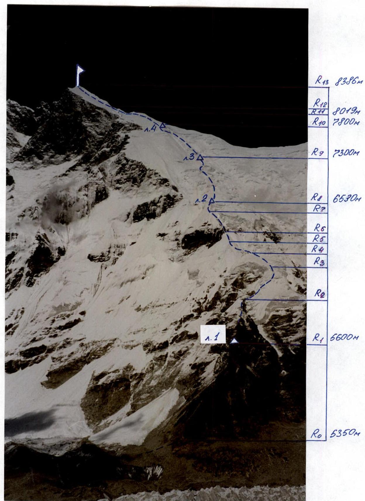
Photo 3. Technical photograph of the route. Taken from the opposite moraine of the glacier.
Map of the area
M 1:50000
Conventional signs: BL — base camp, △ — intermediate camps, — — ascent path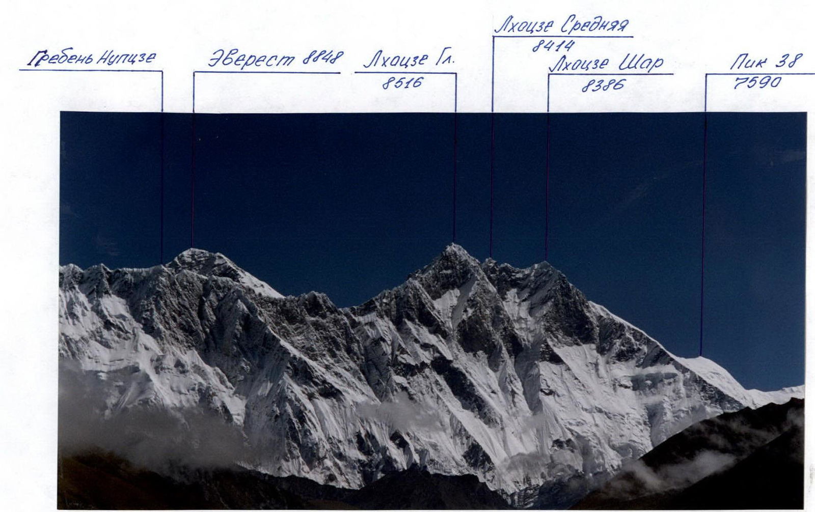
Photo 2. Panoramic photograph of the area.
Tactical actions of the team
Despite extensive preparatory work on studying the ascent area before the start of the expedition, the team did not have a direct description of the route and could only speculate about the difficulties that lay ahead based on their own observations. Therefore, this ascent should be considered a first ascent.
When drawing up the tactical plan, the coaching council adopted the Himalayan ascent tactic. The entire sports composition of the expedition was divided into three groups of five people each. The groups, taking turns, were to lay the path, hang fixed ropes, and set up intermediate camps. The camps were planned to be established at the following altitudes: Camp 1 — 5600 m, Camp 2 — 6500 m, Camp 3 — 7300 m, Camp 4 — 7800 m. The assault on the summit was planned from Camp 4. Each group had sufficient high-altitude experience and qualifications to pass the given route. The good technical and physical preparation of all participants allowed for regular rotation of the lead in the groups. The first person moved with double rope protection (one of which was UIAA), the rest moved along the fixed rope on jumar.
The weather during the expedition was unfavorable. The monsoon did not cease until mid-October. For two hours in the morning, the sun shone, then the wind picked up, the sky clouded over, and snow began to fall. From the second half of October, heavy snowfalls ceased, but hurricane-force winds began to blow above Camp 3.
The team's work on the route began on September 21. On the shoulder, in the lower part of the SE ridge, on convenient rocky sites, Camp 1 (5600 m) was established. The walk here from the base camp took about 2.5 hours. Movement along the moraines and scree was very unpleasant. From now on, this would be the "Advanced Camp" for route processing. On September 25, Camp 2 (6530 m) was set up on top of an ice serac. The camp sites were reliably protected from avalanches, which we repeatedly confirmed during bad weather. Particularly challenging on this section of the route was the R4–R8 segment (see route diagram in UIAA symbols). Movement was complicated by:
- heavy snowfalls,
- a thick layer of fresh snow,
- path processing along snowy ridges-blades in conditions of strong bad weather and poor visibility.
It took the successive efforts of all three groups to process this relatively small section of the route. Due to heavy snowfalls and regularly descending avalanches, route processing was significantly slowed down.
Camp 3 (7300 m) was established on a small site carved on an icy slope under the protection of a bergschrund only on October 11. On this R8–R9 segment, the greatest danger was posed by:
- numerous glacier crevasses,
- high ice movement speed, comparable to the speed on the "Khumbu" icefall.
Each exit when crossing these crevasses required re-hanging the ropes, as the old ones either broke or the crevasses changed beyond recognition, making it impossible to use them.
On the R9–R10 segment, the overall steepness of the route increases. We continued to move through the icefall, avoiding couloirs and gullies. Steep, up to 70°, ice-firn walls were encountered. Numerous glacier crevasses.
Camp 4 (7800 m) was established on a good snowy site under the protection of a bergschrund on October 16. From here, each group made one working exit to further process the route. However, the hurricane-force winds that began at this time allowed for hanging ropes only on the R10–R11 segment, up to the 8019 m mark.
Thus, by the time of the summit assault, the key section of the route, R11–R12, was still unprocessed.
For the decisive assault, the coaching council formed a team of six of the most prepared expedition members:
- Team Captain: Foygt A.V.
- Members: Vinogradsky E.M.
- Timofeev S.V.
- Sokolov G.A.
- Stalkovsky V.V.
- Babanov V.V.
By this time, Camp 4 was equipped with bivouac gear for six people, oxygen equipment (6 masks and 14 cylinders, 2 gas burners with cylinders), a first-aid kit, and dishes. At the end of the fixed ropes (8000 m), the following were left:
- 500 m of fixed rope
- 2 UIAA ropes
- rock, snow, and ice pitons
- chocks.
The team left the base camp on October 26 and reached Camp 4 on October 29. The path to Camp 4 followed the already processed route and did not pose particular difficulties. However, halfway from Camp 3 to Camp 4, an icy wind began to blow. The Camp 4 tent had to be dug out. By night, the wind strengthened, and it became sharply colder. The night at 7800 m was spent under the continuous roar of the wind.
On October 30, the team rose at 3:00. At 6:00, they left Camp 4 and began moving towards the summit. It was very cold. The wind was so strong that each gust knocked the athletes off their feet, and their only salvation was the fixed rope. Reaching an altitude of 7900 m, the team decided that further route processing in such weather conditions was not possible. It was necessary to descend and wait out the bad weather in Camp 4.
On October 31, the wind strengthened even more. On this day, the team spent 4 hours digging out the tent again.
By the morning of November 1, the wind began to subside, and it became clear that this was the only chance — the summit had to be assaulted today. Objectively assessing their capabilities after three nights at 7800 m, and with the aim of increasing safety, the team decided that four people would go for the summit:
- Foygt A.V.
- Vinogradsky E.M.
- Timofeev S.V.
- Sokolov G.A.
Stalkovsky V.V. and Babanov V.V. descended to the base camp.
Initially, it was planned to assault the summit without using oxygen. Oxygen was brought to Camp 4 for medical purposes and in case of severe bad weather. Now, after three nights spent at this altitude, and considering last year's sad experience with V. Bashkirov's team, it was decided to go out with oxygen, having two cylinders per person, to increase safety.
The team began the summit assault on November 1 at 6:00. The wind had subsided, but it was severely cold. At 8:30, they reached the snowy dome at 8019 m, where the fixed ropes ended. The processing of the key section of the route, R11–R12, began (see route description by sections).
Features of passing this section:
- The first person worked on a double rope (one UIAA)
- The rest moved along the fixed ropes with top-rope protection
- About 500 m of fixed rope were hung in total
- The technical difficulty of this section was additionally exacerbated by the altitude of over 8000 m
The pre-summit firn-snow slope (R12–R13 section) was traversed by the team with alternating protection through ice axes with rope team interaction.
At around 8200 m, the oxygen ran out, and the team reached the summit without its use. The ascent to the summit was via a complex snowy wall with a steepness of up to 75°. The snow was coarse-grained, crumbly, and did not compact underfoot. At 17:00 on November 1, the first Russians stood on the summit of Lhotse Shar. The descent from the summit in the dark was not dangerous due to the full moon, as anticipated in the tactical plan.
Thus, the regular rotation of leaders and daily rotation of rope teams allowed for maintaining a high speed during route processing at such altitudes, restoring strength, and ensuring the necessary safety of the ascent.
The team had first-aid kits with a sufficient supply of medications in all camps, and a doctor was constantly present in the base camp. All camps were equipped with bivouac gear, gas cylinders, and oxygen for medical purposes. For high-altitude camps, tents produced in Yekaterinburg were used. Radio communication was stable throughout the days. All participants on the route were provided with two hot meals a day, with dry rations and a flask of tea for lunch.
The route was completed by the team in accordance with the temporary schedule of the tactical plan, adjusted for bad weather, with a safety margin and without failures, which was due to the many years of high-altitude experience of all participants, their high technical, physical, and psychological preparation.
Route diagram in UIAA symbols
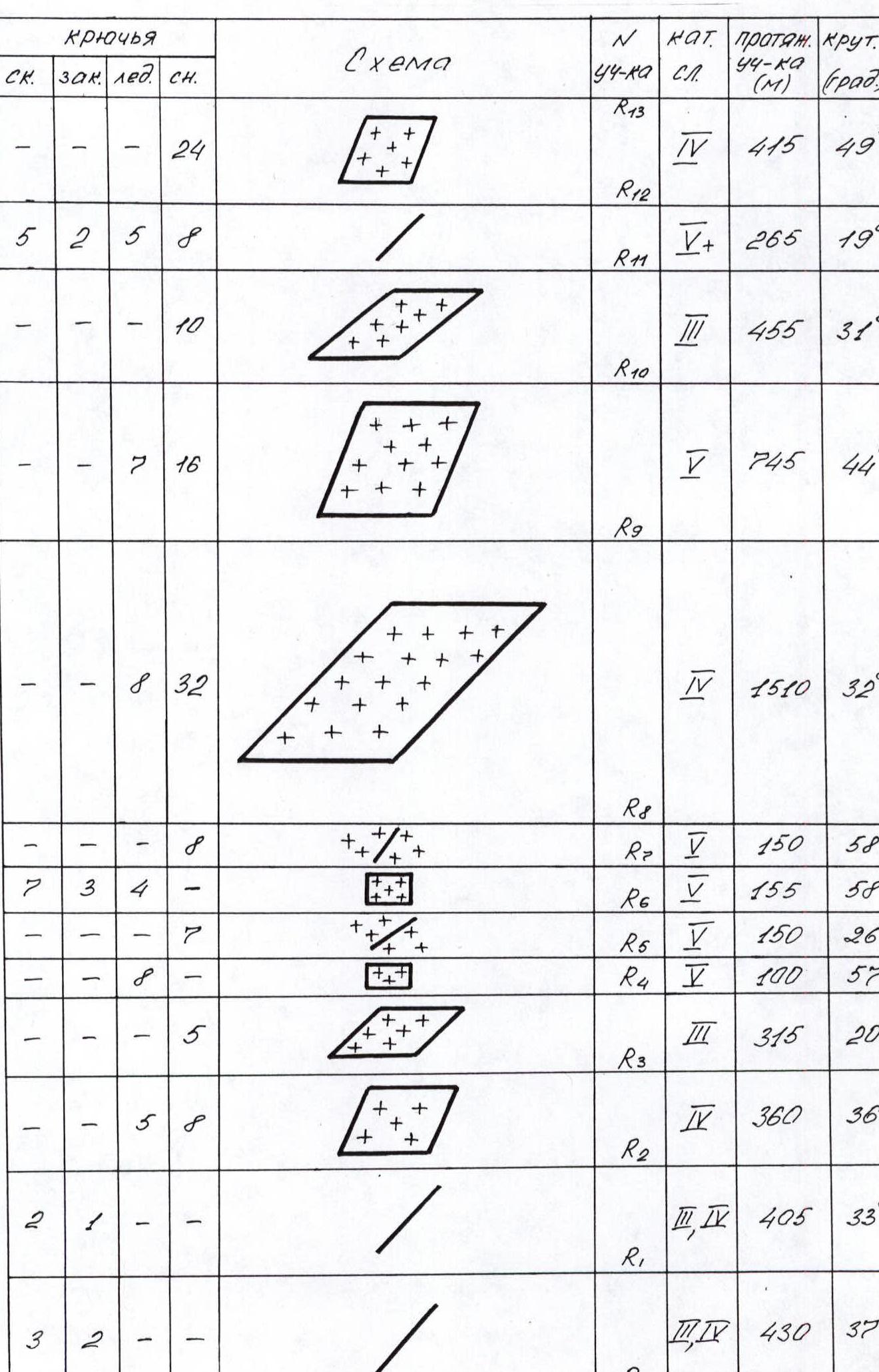
| pitons | Diagram | Section No. | cat. diff. | length (m) | steepness (deg.) | |||
|---|---|---|---|---|---|---|---|---|
| rock | chocks | ice | snow | |||||
| — | — | — | 24 | (diagram) | R13 | 4 | 415 | 49° |
| 5 | 2 | 5 | 8 | (diagram) | R12 | 5 | 265 | 19° |
| — | — | — | 10 | (diagram) | R11 | 3 | 455 | 31° |
| — | — | 7 | 16 | (diagram) | R10 | 5 | 745 | 44° |
| — | — | 8 | 32 | (diagram) | R9 | 4 | 1510 | 32° |
| — | — | — | 8 | (diagram) | R8 | 5 | 150 | 58° |
| 7 | 3 | 4 | — | (diagram) | R7 | 5 | 155 | 58° |
| — | — | — | 7 | (diagram) | R6 | 5 | 150 | 26° |
| — | — | — | 8 | (diagram) | R5 | 4 | 100 | 57° |
| — | — | — | 5 | (diagram) | R4 | 3 | 315 | 20° |
| — | — | 16 | 8 | (diagram) | R3 | 4 | 360 | 36° |
| 2 | 1 | — | — | (diagram) | R2 | 3–4 | 405 | 33° |
| 3 | 2 | — | — | (diagram) | R1 | 3–4 | 430 | 37° |
| — | — | — | — | R0 |
Route description by sections
| Section R0–R1 | Rocky ridge of medium complexity with individual complex walls. Many good ledges for protection organization. At the end of the section, good sites for camping on a rocky ridge. Camp 1. |
|---|---|
| Section R1–R2 | Rocky ridge of medium complexity with steep ascents and individual complex walls. |
| Section R2–R3 | Lower tier of the icefall. Individual ice walls up to 20 m high. Protection through ice and snow pitons. High risk of avalanches after snowfall. Snow is deep and loose. |
| Section R3–R4 | Gentle snowy slope, often broken by deep crevasses. Particularly dangerous is the bergschrund at the end of the section. High risk of snowy avalanches and ice falls from the upper part of the icefall. |
| Section R4–R5 | Ice wall sprinkled with fresh snow on top. Risk of snowy slab avalanches. Protection through ice pitons. |
| Section R5–R6 | Sharp snowy ridge — blade. Snow is loose and deep. Protection through snow pitons. |
| Section R6–R7 | Steep rocky wall covered with ice and snow. Climbing is complex. Protection through rock and ice pitons. |
| Section R7–R8 | Very steep ascent of the snowy-firn ridge-blade to the top of the serac. Movement is psychologically complex — the ridge is very steep, with cornices. Protection through snow pitons. At the end of the section, on the top of the serac, there is a convenient site for camping. Camp 2. The site is safe from avalanches. |
Section R8–R9. Icefall. Relatively gentle ice fields alternate with sharp ascents and fractures. We had to overcome five large crevasses like a bergschrund, with the upper edge significantly higher than the lower. Everything is covered with deep, loose snow. High risk of snowy avalanches after bad weather. Closed crevasses. The peculiarity of this section is that the glacier in this place moves at a very high speed. Each new exit requires re-hanging the fixed ropes on the fractures. Protection through ice and snow pitons. At the end of the section, on an icy slope, a site for Camp 3 is carved under the protection of a bergschrund.
Section R9–R10
- The steepness of the icefall increases.
- The thickness of the snowy cover decreases, turning into firn.
- In the upper third of the section, large fields of pure ice are encountered.
- Protection through ice and snow pitons.
- At the end of the section, there is a good snowy site under the protection of a bergschrund. Camp 4.
Section R10–R11
- The ascent to the snowy dome at 8019 m is relatively gentle.
- Snow, firn, and individual ice sections.
Caution! Several closed crevasses need to be traversed.
Section R11–R12 — a couloir from under the rocky tower of the summit, closely approaching the Eastern ridge, forms a narrow ridge at this point — the key section of the route! "Pine-tree snows" — a snowy relief representing an alternation of:
- "blade-like" snowy ridges,
- gullies of very great steepness.
Snow is as if plastered onto the rocky wall. Very complex climbing. Altitude over 8000 m. Snow is crumbly and poorly compacted. Where possible, protection is organized through rock pitons; in other places, passage of this section is complicated by the state of the snow. The reliability of protection through snow pitons is questionable, and this keeps one in great tension.
Section R12–R13. The pre-summit firn-snow slope has a large steepness. Snow is not deep. Firn is very hard. Several fields of "roof-tile" rocks are encountered. Protection on them is difficult. For movement and protection organization, ice axes were used. The ascent to the summit is via a very steep (up to 75°) snowy wall. On the summit ridge, there are overhanging snowy "mushrooms" complicating the ascent.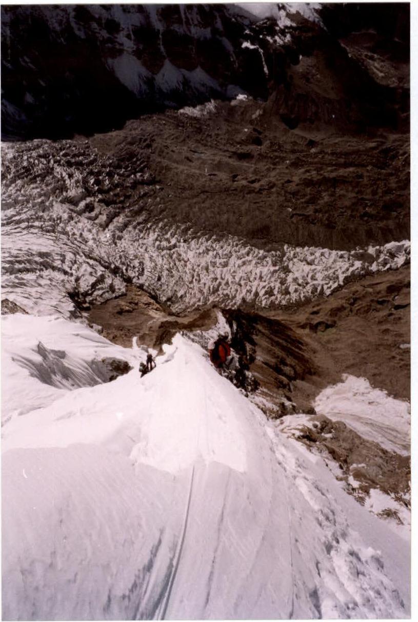
Photo 7. Section R7–R8.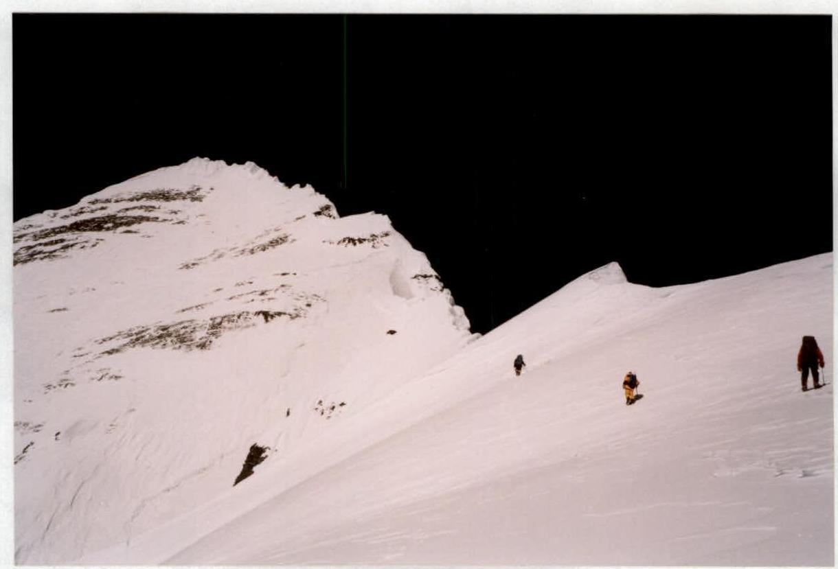
Photo 10. Section R10–R11.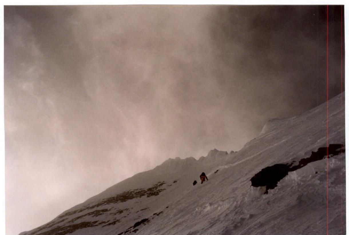
Photo 11. Section R12–R13. The ascent to the summit is visible.