
ST. PETERSBURG ALPINISM FEDERATION
St. Petersburg High-Altitude Climbing Cup 2013
DESCRIPTION OF THE ASCENT TO LHOTSE MAIN (8516 m) VIA THE NORTHWEST FACE COULoir, 5B category
St. Petersburg Team
Team Captain: Viktor Aleksandrovich Koval
Team Coaches:
- Tatyana Ivanovna Timoshenko
- Oleg Viktorovich Kapitanov
Ascent Passport
- Himalayas, section 10.1 of the mountain route classifier
- Peak name: Lhotse Main (8516 m), route name: via the northwest face couloir (Ernst Reiss and Fritz Luchsinger, 1956)
- Category: 5B
- Route type: combined
- Route elevation gain: 3200 m
Route length: 9000 m. Section length: V category — 600 m. Average slope (from the start of the West face at 6900 m): 40°. Key section slope (couloir): 50°
- Number of pitons (denominator for artificial anchors):
rock: 0, chocks: 0, ice screws: 25, bolted anchors: 0. Total artificial anchors used: 0
- Team's total climbing hours: 28 hours, 4 days
- Team Leader: Viktor Aleksandrovich Koval, Candidate Master of Sports
Team Members:
- Sergey Vladimirovich Kondrashkin, Candidate Master of Sports
- Alexey Nikitich Borodenkov, Candidate Master of Sports
- Coaches: Tatyana Ivanovna Timoshenko (Master of Sports), Oleg Viktorovich Kapitanov (Master of Sports)
- Departure for acclimatization and camp setup: April 21, 2013
Departure for the climb: 5:00, May 13, 2013. Summit reached: 13:00, May 16, 2013. Return to Base Camp: 12:00, May 18, 2013.
Route Description and Tactical Actions of the Team
Lhotse is a peak in the Himalayas, the fourth highest eight-thousander in the world (8516 m). It is located in close proximity to Everest, separated from the highest peak by a saddle known as the "South Col" — 7906 m.
Lhotse has 4 peaks. Only two routes have been established to the main peak:
- via the West face (the route of the first ascenders)
- via the South face (USSR Team, 1990)
The ideal season for climbing is April — May.
Up to an altitude of 7700 m, the route coincides with the classic route to Everest. The route to Lhotse starts from the Khumbu Glacier, on the moraine of which the Base Camp is located at an altitude of 5300 m.
The route then passes through the Khumbu Icefall — one of the largest icefalls in the world. The icefall is processed by Sherpas for commercial expeditions.
- At an altitude of 6100 m, at the base of the Western Cwm, Camp 1 is located. The team used the first camp only for the first acclimatization trip. For all subsequent trips, the team went directly from Base Camp to Camp 2 at an altitude of 6500 m.
- From Camp 2, the path leads to the base of the West face of Lhotse. Through the bergschrund and to the left of the ice seracs, which run along the entire right part of the face, the ascent is made up the ice slope with a gradient of about 40°. Winter ice. During the first trip, old fixed ropes and simultaneous protection were used. Subsequently, guides from commercial expeditions set up fixed ropes on the ice face.
- Camp 3 is located on ice ledges to the right of the ascent line at an altitude of 7200 m.
- From Camp 3, the path goes up, then traverses left towards the characteristic yellow rock belt. Ascent up the rocks of the yellow belt (4–5 pitches), then up and to the right towards the rock island. The route to Everest after the yellow belt goes left towards the South Col.
- To the left of the rock island, a place is carved out in the ice for Camp 4 (7850 m), which is used as the assault camp.
- Further up, the path goes up the steep snow slope under the rocks of the Lhotse peak. From an altitude of 8000 m, oxygen is used during the assault climb.
- At an altitude of about 8100 m, a pronounced couloir begins, about 10–15 meters wide, which gradually narrows and turns into an inside corner. The couloir's gradient is about 50 degrees. On the left wall of the couloir, there are old fixed ropes. The lower part of the couloir is snowy, then icy, with short rock walls and slabs, which lead to a ledge 10 meters from the summit.
- From the ledge, a steep rock wall with a gradient of about 65 degrees leads to the summit. The summit drops off to the south with a snow cornice.
Descent is made via the ascent route.
Tactical actions of the team: the "Himalayan style" was used with staged acclimatization and high-altitude camp setup.
Despite the fact that all acclimatization trips up to an altitude of 7950 m and overnight stays, including the overnight stay in Camp 4 at an altitude of 7850 m, were completed without the use of oxygen and the participants felt normal, it was decided to use oxygen during the assault climb from an altitude of 8000 m for the following reasons:
- None of the participants had experience climbing above 8000 m.
- Lhotse is considered one of the "difficult" eight-thousanders.
Results of the assault:
- V. Koval and S. Kondrashkin reached the summit.
- A. Borodenkov reached an altitude of about 8300 m and turned back due to lack of time.
1.5 oxygen cylinders per person were used during the assault with minimal consumption.
During the descent, the team independently removed and evacuated equipment:
- 3 high-altitude camps
- trash
- oxygen cylinders
- other equipment
No porters, Sherpas, or other assistance were used on the route.
Expedition schedule:
- Days 1–7: trekking Lukla (2800 m) — Base Camp (BC) on the Khumbu Glacier (5300 m)
Day 8: rest at BC
Days 9–11: BC — Camp 1 (6100 m) — Camp 2 (6500 m) — BC
Days 12–13: rest at BC
Days 14–17: BC — Camp 2 (6500 m) — Camp 3 (7200 m) — BC
Days 17–20: rest at BC
Days 21–25: BC — Camp 2 (6500 m) — Camp 3 (7200 m) — Camp 4 (7850 m) — BC
Days 26–29: BC — Dingboche (4300 m) — BC (descent for rest)
Days 30–34: BC — Camp 2 (6500 m) — Camp 3 (7200 m) — Camp 4 (7850 m) — assault on the summit
Days 35–36: descent to BC
Days 37–40: trekking BC (5300 m) — Lukla (2800 m)
Technical Photos
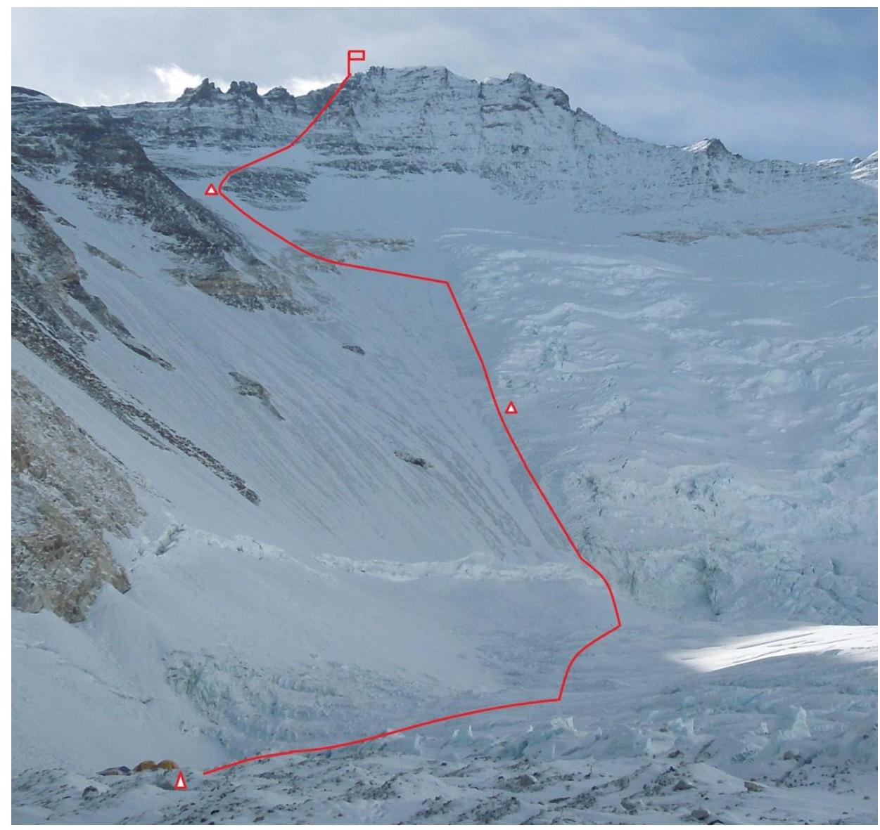
View of the West face of Lhotse from the Western Cwm from Camp 2
On the photograph are marked:
- Camp 2 (6500 m)
- Camp 3 (7300 m)
- Camp 4 (7850 m)
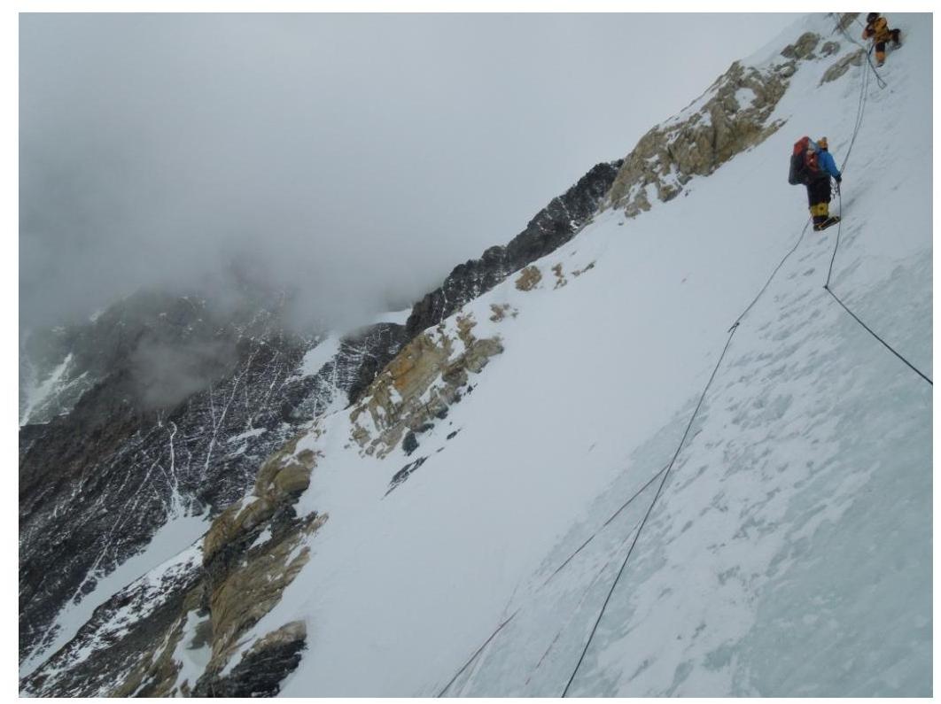
Approaching the "yellow belt" rock at an altitude of 7700 m
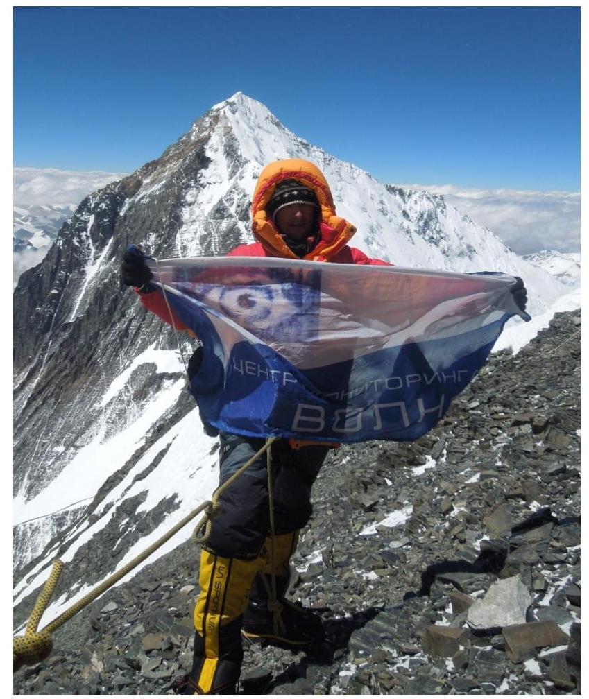
On the ledge 10 meters from the summit:
- S. Kondrashkin (top)
- V. Koval (bottom)
May 16, 2013
In the background — Everest