
Ermolaeva, along the southern ridge — Vodolazko S.I. "Badzhal Range"
II A C II O P T I. Combined route.
-
Badzhal Range, Ulun gorge.
-
v. Ermolaeva, along the southern ridge. 4. Proposed — 1B cat. diff. first ascent.
-
Height difference: 350 m, length — 700 m.
Average steepness of the main part of the route — 30°.
- Pitons left on the route — none.
Used previously driven pitons and not knocked out — none.
-
Travel hours — 5 hours.
-
Overnights: in the base camp at the confluence of the tributaries of the Ulun River.
-
Leader: Vodolazko Sergey Ivanovich — 2nd sports category;
participants:
- Grizhobovsky Yuri Gennadievich — "znakhochok"
- Lantsevich Sergey Vladimirovich — 2nd sports category
- Polukarikov Vitaly Germanovich — 2nd sports category. 10. Coach: Zverev Dmitry Yurievich — 1st sports category. II. Departure on the route: March 9, 1991.
Summit — 13:00; return — 15:00. 12. Organization — Khabarovsk Krai section of mountaineering. 1. Description of the ascent route to v. ERMOLAEVA (2158 m) along the Southern ridge 1B cat. diff.
From the base camp, move along the right bank of the right tributary of the Ulun River. After 20–25 minutes of movement, start climbing up along the snow-covered couloir to the left of the rightmost counterfort of the summit. Having passed 80 m, move to the right onto the counterfort and move along it.
The counterfort is:
- heavily snow-covered rocks
- несложное лазание (simple climbing - kept as-is due to being a quote, although it is in Russian, the context implies it should be translated, a more accurate translation would be 'not difficult climbing')
- simultaneous movement in ropes
Before exiting onto the southern ridge, leave the counterfort to the right onto the snowy slope, bypassing the "gendarm". Time to climb to the ridge I, 5–2 hours from the start of the ascent.
Having reached the ridge, move in ropes. The ridge is narrow, movement is alternating.
Having passed along the ridge for 90–100 m, exit onto a forty-meter snowy ridge. Move along the ridge with alternating belay. On the snowy ridge to the left — cornices! Organize belay through an ice axe.
Further:
- bypass the pre-summit rise of the ridge along snowy inclined shelves (alternating movement, 30–40 m);
- exit onto несложные заснежые скалы (not difficult snow-covered rocks);
- pass 20 m along the rocks and exit onto the summit.
The summit is a gentle snowy dome, turning into a ridge.
Descent from the summit:
- Along the ascent route with hanging rappel lines practically along the entire ridge section of the route.
- Descent from the ridge is carried out to the left of the counterfort along the edge of the snow-covered couloir.
- Simultaneous movement in ropes.
Duration:
- Descent from the summit along the ridge: 40–50 minutes.
- Descent from the ridge along the counterfort: 15–20 minutes.
- Total ascent time: 4–5 hours.
Assessment of the route's safety.
Hazards for mountaineers are:
- snowy cornices on the snowy ridge (length 40 m);
- when descending from the ridge along the couloir — possible undercutting of the snowy slope and avalanche danger.
RECOMMENDATIONS FOR SUBSEQUENT GROUPS ON THE USE OF EQUIPMENT AND FEATURES OF THE ROUTE.
Mandatory presence in the group of crampons for each participant, for a group of 6 people — 3–5 rock pitons and 3 rappel loops. It is possible to secure the rope and belay to outcrops. Pay special attention to the organization of belay and securing of rappel lines on the snowy ridge with cornices.
Characteristic signs of the start of the route.
The start of the route is located below the counterfort, exiting onto the rightmost "gendarm" of the ridge (see photo).
MAP-SCHEME OF THE ASCENT AREA: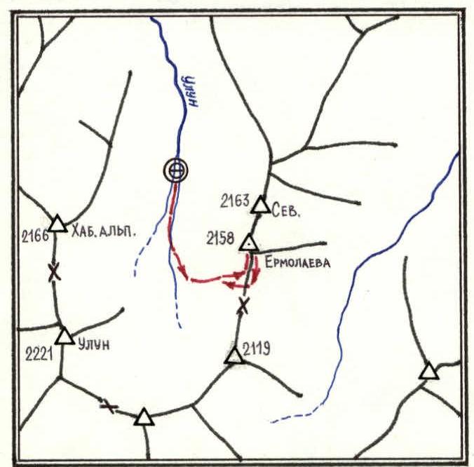
SCALE: 1:50,000 (in 1 cm — 500 m)
ERMOLAEVA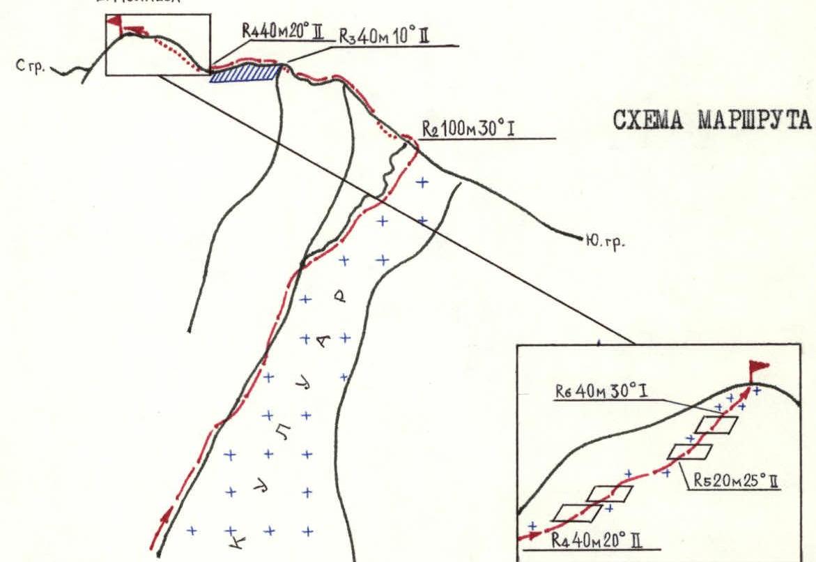 R1
400 × 45° I·I
R1
400 × 45° I·I