
-
Climbing category — technical
-
Climbing area — Pamir-Alai, Turkestan Range, KTM TV 5.4
-
Peak 4750 (p. LOMO) — via the North Ridge, combined route, first ascent
-
Proposed difficulty category — 5B
-
Length — 1950 m
including: length of 5–6 difficulty category — 400 m, including 6 difficulty category — 75 m. Average steepness of the main part — 64°. Height difference — 1150 m.
-
Pitons driven:
- rock: 46/4
- chocks: 59/0
- bolt: 1/0
- ice: 10/0
-
Number of climbing hours — 31, 3 days
-
Overnight stays — lying down, platforms cut out in the snow-ice slope
-
Leader — Oleg Stanislavovich Klyunin — Candidate for Master of Sports
Team members:
- Marina Albertovna Belova — Candidate for Master of Sports
- Elena Yurievna Glushko — Master of Sports
- Sergey Georgievich Kritsuk — 1st sports category
- Andrey Petrovich Sagurov — 1st sports category
-
Coach — Vyacheslav Ivanovich Glushko, Master of Sports of the USSR
-
Approach to the route — June 19, 1988 Summit — June 21, 1988 Return — June 22, 1988
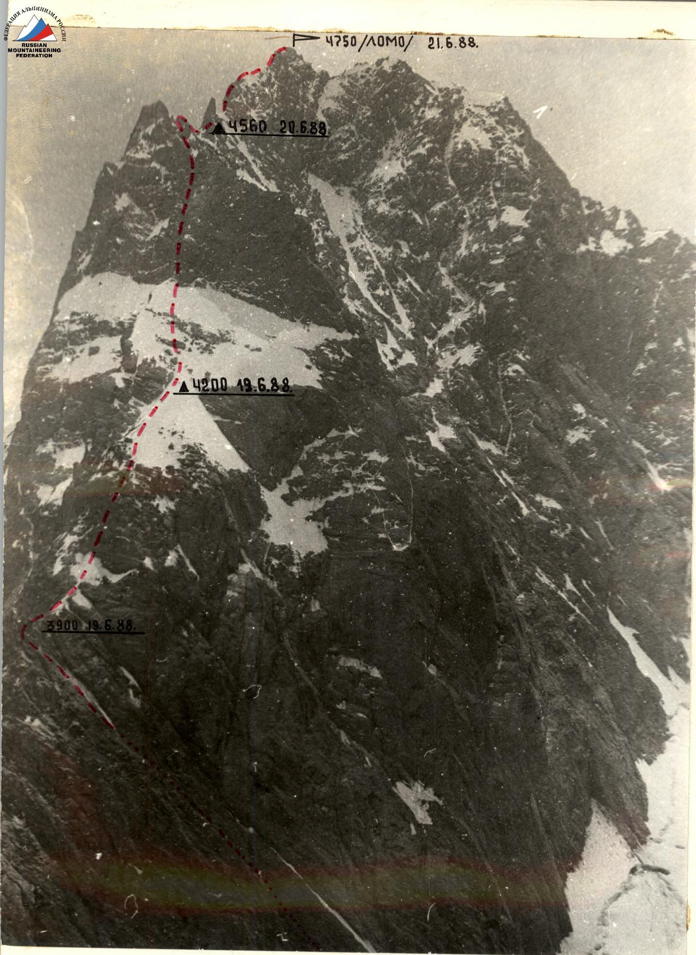
Photo S1 Date taken — July 4, 1988 Lens — Industar-52 Distance — 1000 m Height — 4000 m Photo number — 1
PROFILE OF THE ROUTE TO PEAK 4750 P. LOMO VIA THE NORTH RIDGE VIEW FROM THE RIGHT
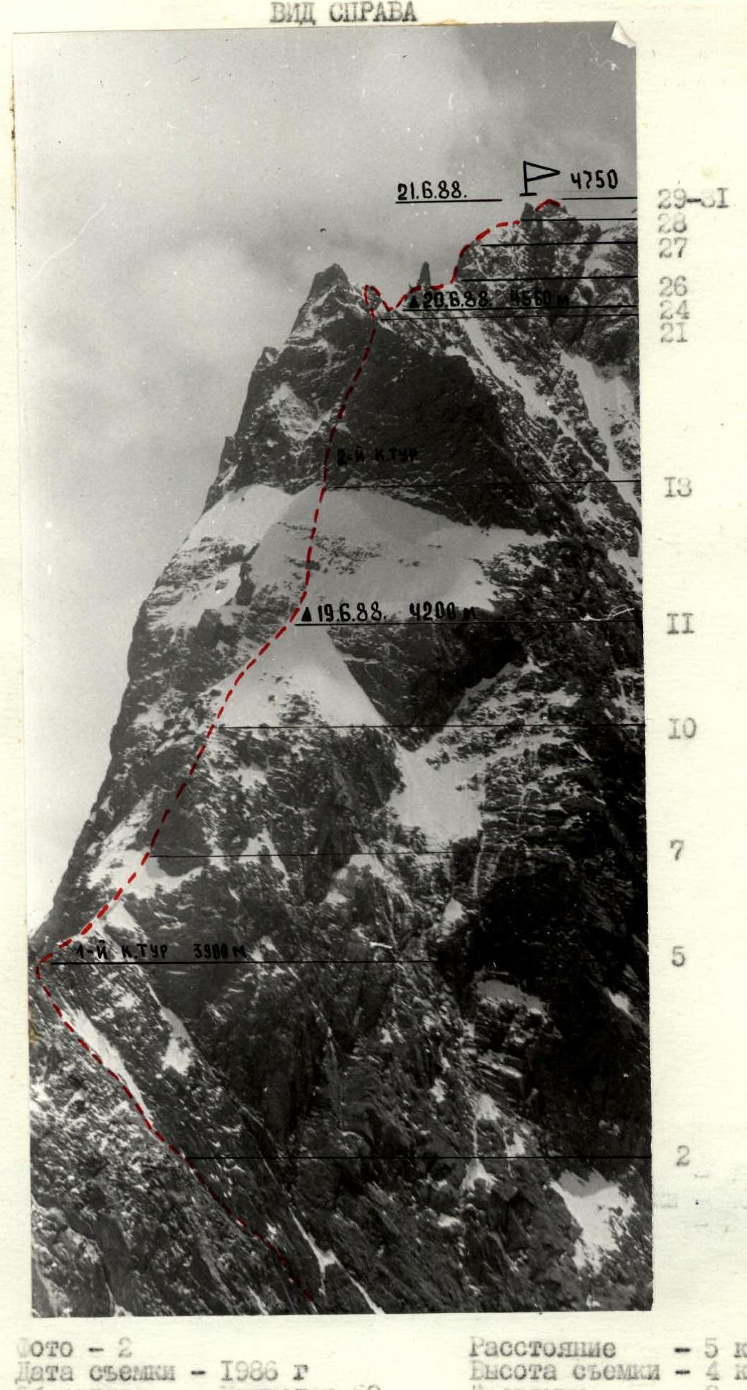
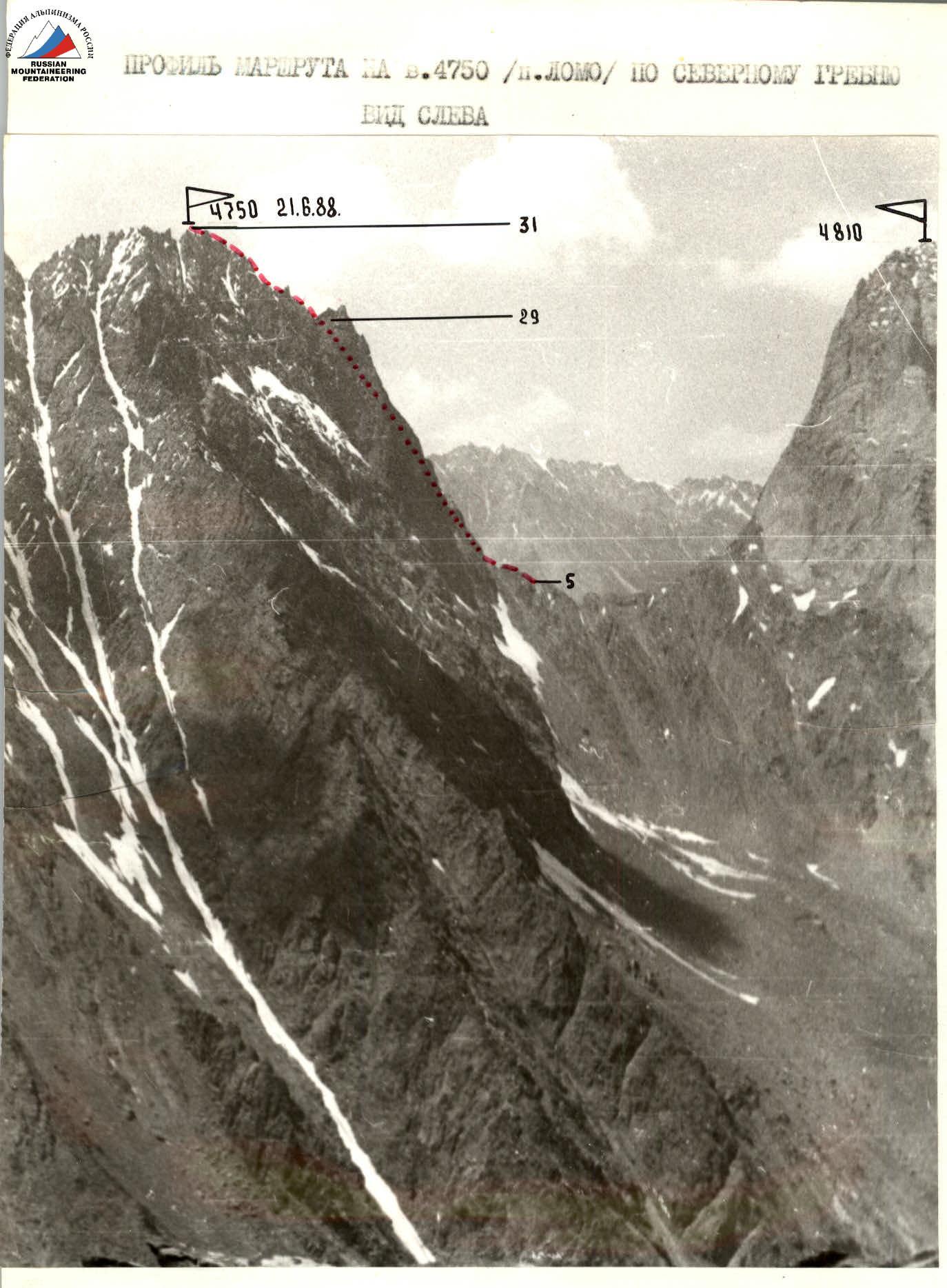
Photo — 3 Date taken — June 26, 1988 Lens — Industar-52 Distance — 4 km Height — 4000 m Shooting point — 3
The tactical actions of the team were determined by a tactical plan (see appendix), which was largely executed. Preliminary reconnaissance and observation of the route along the North Ridge to peak 4750 (p. LOMO) were conducted, and the descent path from the summit was also examined. The team was composed of 5 people:
- Oleg Stanislavovich Klyunin — captain — Candidate for Master of Sports
- Elena Yurievna Glushko — Master of Sports
- Marina Albertovna Belova — Candidate for Master of Sports
- Sergey Georgievich Kritsuk — 1st sports category
- Andrey Petrovich Sagurov — 1st sports category
On June 18, 1988, the group planned to process the lower part of the rocks and photograph the route. On June 19, 1988, traversing the counterfort, reaching the saddle, traversing it, and starting work on the wall section of the route. On June 20, 1988, reaching the pre-summit ridge. On June 21, 1988, reaching the summit and descending to the base camp. Since it was a first ascent, the tactical plan provided for several options for both ascent and descent from the summit. The path to the saddle along the rocky counterfort passes through strongly destroyed rockfall-prone terrain and requires extreme caution. The saddle between peaks 4810 and 4750 is also a strongly destroyed ridge. Movement is in rope teams with simultaneous and alternate belays. The main technical difficulty of the route is the constant alternation of complex rock and snow-ice terrain. In some places, the change in terrain occurred over the length of one rope (40 m). All ridge sections of the route are heavily destroyed, often with snow cornices and overhangs. The terrain allows for the use of protrusions for belay station organization. Throughout the entire route, the first rope team consisted of Klyunin — Sagurov A. On rock sections, Sagurov worked first in climbing shoes, and on snow-ice sections, Klyunin worked first in boots and sometimes in crampons. The second rope team consisted of Belova M. — Glushko E. — Kritsuk S. The duties of this team included supplying equipment to the first team, organizing communication, and photography. Kritsuk S worked last throughout the route. Rope pull-through was used during the ascent. Wall sections were traversed with interaction between rope teams, while ridge sections were traversed independently. The key to the route is the wall section between R20–R21, overcoming which requires high rock climbing technique and the use of diverse mountaineering equipment. Safety measures included:
- High physical, technical, and psychological preparation;
- Excellent knowledge of mountain-climatic conditions, ration, information, and, as a result, a tactical plan;
- Excellent material support, including the use of modern equipment;
- Availability of stable radio communication;
- Interaction with the Smirnov — Pashkin A. group (monitoring movement via radio communication)
| Rock | Chocks | Bolt | Ice | Notes | Section | Length (m) | Steepness (°) | Category |
|---|---|---|---|---|---|---|---|---|
| 2 | 1 | - | - | R30 | 40 | 75 | 5 | |
| - | - | - | - | R29 | 30 | 45 | 3 | |
| 3 | 1 | - | - | R28 | 40 | 75 | 5 | |
| - | - | - | - | R27 | 40 | 50 | 3 | |
| 2 | 3 | - | - | R26 | 40 | 70 | 5 | |
| - | 2 | - | - | R25 | 40 | 30 | 3 | |
| - | 1 | - | - | overnight stay June 20, 1988 | R24 | 60 | 40 | 3 |
| - | 2 | - | - | R23 | 60 | 30 | 3 | |
| - | 1 | - | - | R22 | 60 | 55 | 4+ | |
| 2 | 1 | - | - | R21 | 40 | 50 | 4 | |
| 8 | - | 1 | - | R20 | 40 | 85 | A4 | |
| 9 | 1 | - | - | R19 | 15 | 50 | 5 | |
| 3 | - | - | - | traverse 15 m | R18 | 10 | 70 | 5 |
| 2 | 2 | - | - | R17 | 35 | 80 | 6 | |
| 2 | 3 | - | - | R16 | 20 | 70 | 5 | |
| 2 | 3 | - | 1 | R15 | 40 | 80 | 5 | |
| 2 | 1 | - | - | R14 | 20 | 80 | 5 | |
| 4 | 1 | - | - | traverse | R13 | 20 | 80 | 5+ |
| 4 | - | - | 6 | R12 | 40 | 55 | 5 | |
| 2 | - | - | 2 | overnight stay June 19, 1988 (4200 m) | R11 | 80 | 50 | 4+ |
| - | - | - | - | R10 | 120 | 45–55 | 4 | |
| 4 | - | - | - | R9 | 40 | 60 | 4 | |
| 2 | 1 | - | - | R8 | 20 | 70 | 5 | |
| 3 | - | - | - | R7 | 20 | 85 | 5+ |
Description of the route by sections
Section R0–R1. Snowy couloir to the right of the counterfort. 200 m, 40°, 3rd category.
R1–R2. Series of heavily destroyed ledges, walls, and internal corners of the counterfort. 250 m, 45–60°, 2–4 category. Many loose rocks.
R2–R3. Transition to the left part of the counterfort, movement along an inclined ledge representing prolonged rocks, followed by movement along the central part of the counterfort. Attention to rockfall hazard. Length 40 m, 60°, 4th category.
R3–R4. Movement along the counterfort, heavily destroyed rocks, rockfall hazard. 50 m, 60°, 4th category.
R4–R5. Along the counterfort, through a snowy cornice, exit to the saddle between peaks 4810 and 4750. Control cairn. 60 m, 40°, 3rd category.
R5–R6. From the control cairn — sport descent towards peak 4750. Further movement along the ridge, sticking to its left part. The ridge is heavily destroyed, with snowy cornices. Simultaneous movement, partially alternate, belaying off protrusions. 300 m, 40–60°, 3–5 category.
R6–R7. Steep snowy slope with rocky outcrops. Snow on ice. Piton belay. Length 80 m, 50°, 4th category.
R7–R8. Rocky wall. Piton belay. 20 m, 85°, 5+ category.
R8–R9. Internal corner. Destroyed rocks. 20 m, 70–80°, 5th category.
R9–R10. Internal corner. Heavily destroyed rocks, loose rocks on ledges. 40 m, 60°, 4th category. Piton belay. Ropes.
R10–R11. Snowy slope with rocky outcrops, transitioning into a snowy ridge. Belaying off protrusions. On steep sections — ropes. Alternate movement. 120 m, 45–55°, 4th category.
R11–R12. On the ridge, a convenient place for an overnight stay. Upwards to the left along a snowy slope with rocky outcrops. Snow on ice. Belaying using rock and ice pitons. 80 m, 50°, 4+ category.
R12–R13. Snow-ice slope with rocky outcrops. Belaying via rock and ice pitons. Ropes. 40 m, 55°, 5th category.
R13–R14. Traverse along the boundary between ice and rocks. Piton belay. Ropes. 20 m, 80°, 5+ category.
R14–R15. Upwards to the left — internal corner. Destroyed rocks. Piton belay. 20 m, 80°, 5th category.
R15–R16. Internal corner transitioning into a chimney filled with ice. Monolithic rocks. Belaying via rock and ice pitons. 40 m, 80°, 5th category. Control cairn.
R16–R17. Upwards to the left along rocky walls. Destroyed rocks. Piton belay. Ropes. 20 m, 70°, 5th category.
R17–R18. Upwards to the left along an internal corner, leaving a snowy cornice to the right above, exiting onto a rocky wall. 35 m, 80°, 5th category.
R18–R19. Then 10 m upwards onto a rocky "fin". 10 m, 70°, 5th category.
R19–R20. Traverse 15 m (for the last — pendulum), to the base of an internal corner. 15 m, 80°, 5th category.
R20–R21. Internal corner, overhanging in the upper part. Piton belay. Bolt piton driven. The overhanging part of the internal corner is traversed using artificial aids. 40 m, 85°, 5th category, A4. Exit onto the ridge.
R21–R22. Along the right part of the ridge along the boundary between snow and rocks, exiting under rocky slabs. Belaying via chocks and protrusions. Alternate movement. 40 m, 50°, 4th category.
R22–R23. Rocky slabs with many loose rocks on ledges. Belaying via chocks and protrusions. 60 m, 55°, 4th category.
R23–R24. Exit onto the ridge along a system of ledges and small walls and further along the ridge to a pronounced lowering in it. Overnight stay location. (Belaying off protrusions and chocks). Simultaneous movement. 60 m, 30°, 2nd category.
R24–R25. Heavily intersected ridge with many loose rocks and snowy drifts. Belaying off protrusions. Simultaneous movement. 60 m, 40°, 2nd category.
R25–R26. Bypassing a "finger" gendarme to the right. Belaying off protrusions and rock pitons. Alternate movement. 40 m, 30°, 2nd category. Along the snowy ridge, approaching under a rocky wall.
R26–R27. Rocky wall. Rocks are destroyed. Piton belay. Ropes. 40 m, 70°, 5th category.
R27–R28. Along the snowy ridge under a series of rocky gendarmes. 40 m, 50°, 2nd category.
R28–R29. Gendarmes are traversed head-on. Belaying via rock pitons, chocks, and protrusions. Alternate movement. 40 m, 75°, 5th category.
R29–R30. Along the snowy ridge and further traversing a snowy-ice slope to the right, exiting under the summit tower. 30 m, 45°, 2nd category.
 R30–R31. Along the snowy ridge, exit to the summit along a rocky wall. Rocks are relatively monolithic. Belaying via rock pitons and chocks. Ropes. 40 m, 75°, 5th category.
Descent from the summit towards the saddle between peaks 4750 and 4925 along a heavily destroyed ridge. Belaying off protrusions. Simultaneous and partially alternate movement. From the saddle, descent is possible along a snowy couloir:
- towards the Ak-su gorge
- towards the Kara-su gorge
Descent from the summit to the Kara-su valley takes 3 hours 30 minutes.