
ASCENT DOCUMENT
-
Technical class.
-
Pamir-Alay, Ak-Su valley.
-
Mt. East A. Blok (5150 m), via northwestern wall and northern ridge.
-
Category 5B, third ascent.
-
Elevation gain 830 m.
Average length 1008 m. Average slope 65°. Average wall slope 75°. Length of sections with 5th and 6th difficulty categories 315 m.
-
Pitons used: rock: 86/20 bolted: – chocks: 48/7 ice: 13/7
-
Climbing time 29 hours, duration 3 days.
-
Overnight bivouacs.
-
Team leader: Evgeny Alexandrovich Almuhamedov, 1st sports category.
Team members:
- Anatoly Igorevich Butenko, Candidate Master of Sports
- Oleg Yurievich Muravyov, 1st sports category
- Andrey Valentinovich Novikov, 1st sports category
-
Coach: Andrey Yuvenalievich Zhila, Master of Sports of the USSR.
-
Approach to the route on July 7, 1988.
Summit day: July 8, 1988. Return to the col on July 9, 1988.
-
Mountain club "Irkut".
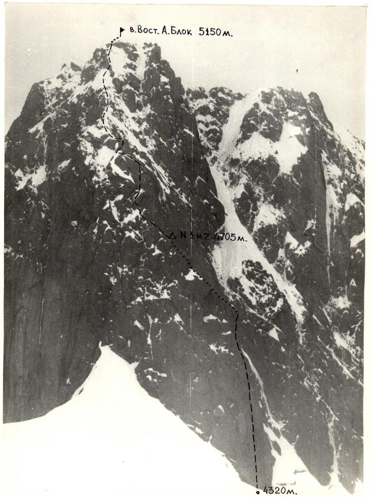
Photo 1. General view of the summit. Taken on July 5, 1988, from the slopes of Mt. Aktubek (5400 m). Shooting point 1. Distance 2.5 km. Lens "Helios 44-2" 58 mm.
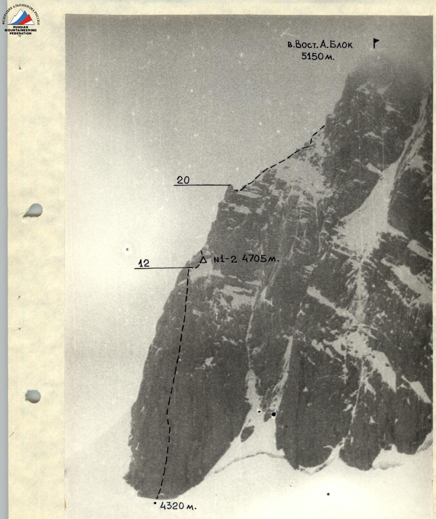
Photo 2. Profile of the wall from the west. Taken on July 9, 1988. Shooting point 2 (4200 m). Distance 2 km. Camera LOMO 135.
Route diagram in symbols

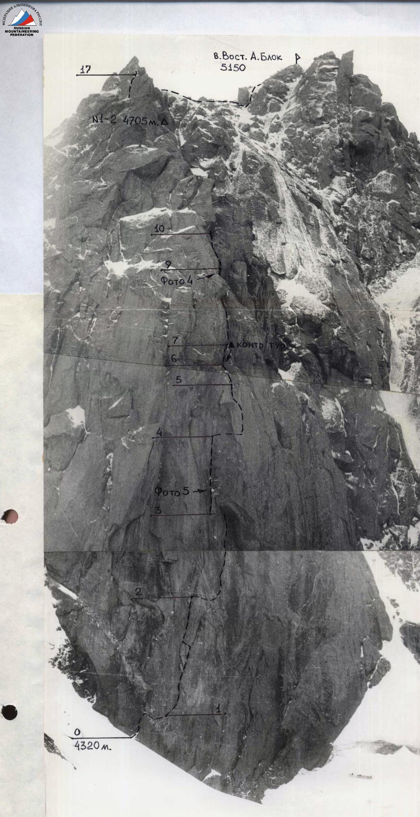
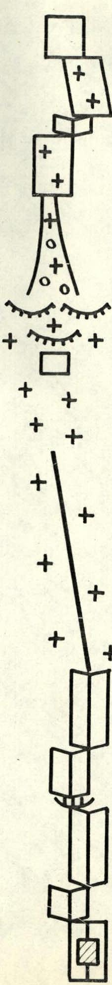
Photo 3. Technical photo. Taken on July 5, 1988. Shooting point 3 (4350 m). Distance 250 m. Camera LOMO 135.
| Rock (pcs.) | Ice (pcs.) | Chocks (pcs.) | Length (m) | Slope (°) | Category |
|---|---|---|---|---|---|
| 2 | 2 | 20 | 85 | V | |
| 1 | 1 | 30 | 50 | IV | |
| 1 | 1 | 10 | 80 | IV | |
| 3 | 1 | 3 | 30 | 85 | V+ |
| 5 | 2 | 50 | 75 | IV | |
| 3 | 1 | 30 | 70 | IV+ | |
| 2 | 2 | 10 | 90 | V+ | |
| 1 | 40 | 65 | III+ | ||
| 3 | 4 | 110 | 60 | III–IV | |
| 5 | 4 | 40 | 90 | V+ | |
| 3 | 2 | 25 | 70 | V– | |
| 3/3 | 5 | 95 | VIA3 | ||
| 7 | 3 | 40 | 90 | V+ | |
| 3 | 1 | 18 | 75 | IV | |
| 5/5 | 3/3 | 20 | 85 | VIA3 | |
| 5/3 | 2/1 | 10 | 90 | VI | |
| 2 | 2 | 20 | 80 | V+ | |
| 10/5 | 5 | 25 | 90 | VI | |
| 14/7 | 3 | 35 | 85 | VI | |
| 2 | 1 | 15 | 80 | V+ |
This route demands the highest level of technical and psychological preparation from the athletes. The decisive factors for a successful ascent are the style of wall climbing, the team's technical equipment, its physical and technical preparedness, and, as a result, a high pace of route progression.
Based on the task at hand, the team adopted the following movement scheme:
- the first climber ascends without a backpack, with double-rope belay;
- each subsequent climber also works with a double rope: one rope serves as a "handrail," and the other as a top belay.
- the third climber is an exception, moving along the double "handrails."
This scheme ensures not only a high pace of movement but also sufficient reliability.
In our opinion, the value of climbing a complex wall is diminished by preliminary processing. Therefore, this stage was excluded from the tactical plan.
The entire route was planned to be completed in three days, with:
- a double overnight stay at one location.
- no deviations from the tactical plan during the ascent.
- the route was confidently completed by the team with a significant reserve of physical and technical resources.
22–23: rock-ice internal corner leading to a snowy slope.
23–24: snow-ice-rock ridge. Caution! Snow cornices on the left. Move upwards, sticking to the right side. Bypass gendarmes on the right. Move in crampons.
24–25: ridge expansion, increasing steepness. Exit to the summit. Before the summit — a 15 m rock wall, climbed via an internal corner in the center.
Descent from the summit follows the ascent route until the gendarme at the top of section 11–12. Then down the wall to the snow.
Route description by sections
0–1. Inclined slab. Limited number of cracks. Move upwards to the piton, then right, down to a faintly marked ledge and right along it.
1–2. Internal corner. Move upwards through an overhang to the fork in the crack. Good crack for medium-sized chocks and boxes. Transfer to the left crack.
Internal corner. Move upwards to three small oblique ledges. Universal pitons go well.

Internal corner. Move upwards and then right onto a slab leading under a large cornice ("ceiling").
2–3. Slab. Move upwards through a series of cracks under the "ceiling." Limited number of cracks in the upper part of the slab. Traverse left by pendulum to the lower part of a flake. Limited number of cracks. Difficult climbing.
3–4. Flake. Up the flake to a good ledge (1 m × 1.5 m). Internal corner. Up it to three hanging stones. Attention!!! Loose stones. Do not touch them!
4–5. Slab. Traverse left across the slab behind the bend along a ledge. Limited number of cracks.
Slab. Move upwards along the right crack. Use artificial footholds. Then transfer to the left crack into an internal corner.

Internal corner. Up it to a ledge.
5–6. From the ledge, across "sheep's foreheads" to another good ledge (2 × 3 m). Control cairn. Ledge slope 10°. Ice present.
6–7. Internal corner. Rocks like "sheep's foreheads".
7–8. Large internal corner. Small overhang in the upper third. Use artificial footholds.
8–9. Overhanging internal corner. "Zailzug". Good for large and medium-sized chocks.
9–10. System of oblique internal corners leading to an inclined ledge under a large, overhanging "feather".
10–11. Bypass the "feather" on the right. Large internal corner. Move along the right edge of the corner. Then transfer into the internal corner itself.
Internal corner leading to an auxiliary ridge.
11–12. Move along the ridge. Snow-covered and icy rocks. Move in crampons to a pronounced gendarme. Descent from the summit begins from this point down the wall.
12–13. Bypass the gendarme on the right along the edge of a large snowfield to a good ledge with a snow "deposit". The ledge is protected from falling stones by a large rock cornice. Overnight bivouac.
13–14. Wall. From the far edge of the ledge, upwards through an internal corner leading to snow-covered and icy "sheep's foreheads".
14–15. "Sheep's foreheads" forming an internal corner. Up the "sheep's foreheads" under the base of the wall. Move in crampons. Transfer left behind the bend into a couloir.
15–16. Snow-ice couloir with outcrops of broken rocks. Up it under the wall. Move in crampons.
16–17. Ice-filled oblique internal corner in the center of the wall. Many thin, unreliable flakes (scales) on the edges. From the upper part of the corner, right and up to a ledge.
17–18. Internal corner leading to a wide, snow-covered inclined slab. Good, safe ledge for an overnight bivouac in the far right corner of the slab.
18–19. Inclined slab. Left across the slab and then along a snow-ice ledge to bypass a gendarme to the ridge. Move in crampons.
19–20. Wall. Up and left across the wall with many unreliable flakes. Exit to the main ridge.
20–21. Ridge. Descent from a gendarme.
21–22. Bypass a hanging rock wall on snow to a rock-
Tactical actions of the team
During the ascent, the tactical plan was fully implemented. Deviations from the planned time for individual sections were anticipated by the tactical plan variants and did not exceed 1 day; the overall duration on the route did not exceed the planned 10 days. The complicated state of traverse sections with northern and northeastern exposure was anticipated, and additional time was allocated in the tactical plan for their passage (ascent to Mt. East A. Blok, section Mt. East A. Blok — A. Blok (Main), ascent to Mt. North AkSu).
On most of the traverse, "handrail" technique was used, necessitated by the complicated state of the route.
Before starting the route, during training outings and sessions, the team members made 2 caches (after Mt. A. Blok (Main) and after Mt. 4600), which reduced the initial backpack weight.
Throughout the traverse, the team maintained an approximately 10-hour workday, with the leading rope team changing daily, distributing the workload fairly among its members; thus, everyone in the team took turns leading. On all stages, the leaders in the rope teams moved with shock absorbers, an additional safety measure. Key sections of the route — ascent to Mt. East A. Blok, A. Blok (East) — A. Blok (Main), ascent to Mt. North AkSu — were climbed with daily preliminary processing, done in the evening hours (from 18:00 to 20:30) after the entire team stopped for a bivouac, during which time the daily bad weather ceased.
When climbing icy sections of the route, ice axes and twenty-tooth crampons of the "footfing" type were used.
Throughout the route, the team had a sufficient safety margin, manifested in a reserve of food, fuel, physical strength, and the team's morale.