
PASSPORT
- Class — High-altitude technical.
- Region — Pamir-Alay, Ak-terek spur of the Turkestan Range.
- Peak Skalisty, Southeast summit 5450 m, via the eastern wall of the South ridge.
- 6B category of difficulty, second ascent, repetition of the gold medal route of the USSR Championship 1982.
- Height difference 1600 m, length — 2200 m.
Length of sections with 5–6 category of difficulty — 1722 m, of which 6 category of difficulty — 572 m. Average steepness by sections:
- 4100–4750 m — 79°
- 4750–5280 m — 72°
- 5150–5450 m — 74°
- Pitons driven
| Rock | Nuts | Bolt | Ice | |
|---|---|---|---|---|
| Total | 276 | 193 | 6 | 13 |
| Of which I.T.O. | 51 | 62 | 6 | 0 |
- Climbing hours — 82, days — 8
- Overnights
1 — lying in a bergschrund, 2–3 — semi-reclining — on a ledge, 4 — sitting, on two levels, on ledges, 5 — semi-reclining, carved in a snow-ice ridge, 6 — sitting on an ice ledge, 7 — semi-reclining — on a ridge.
- Team LOS DSO "Burevestnik"
Leader: Bashmakov Mark Ivanovich — CMS. Members:
- Arsentyev Sergey Anatolyevich — CMS
- Konovalov Yuri Viktorovich — CMS
- Mozhaev Mikhail Vasilyevich — CMS, 188631, 7% metal structure, ul. Bochaychuka 20–37
- Solovyov Sergey Anatolyevich — CMS
- Shpynev Gennady Petrovich — CMS
- Coach: Bashmakov Mark Ivanovich — CMS.
- Approach to the route July 20, 1983.
Summit July 27, 1983, return July 28, 1983.

General view of the route. --- bivouac sites --- group path
TABLE OF MAIN CHARACTERISTICS OF THE ASCENT ROUTE
Ascent route: Peak Skalisty — SE summit via E wall of S ridge.
Route length: 2200 m.
Route height difference: 1600 m.
Length of most difficult sections: 1722 m.
Route steepness: 79°–72°–74°
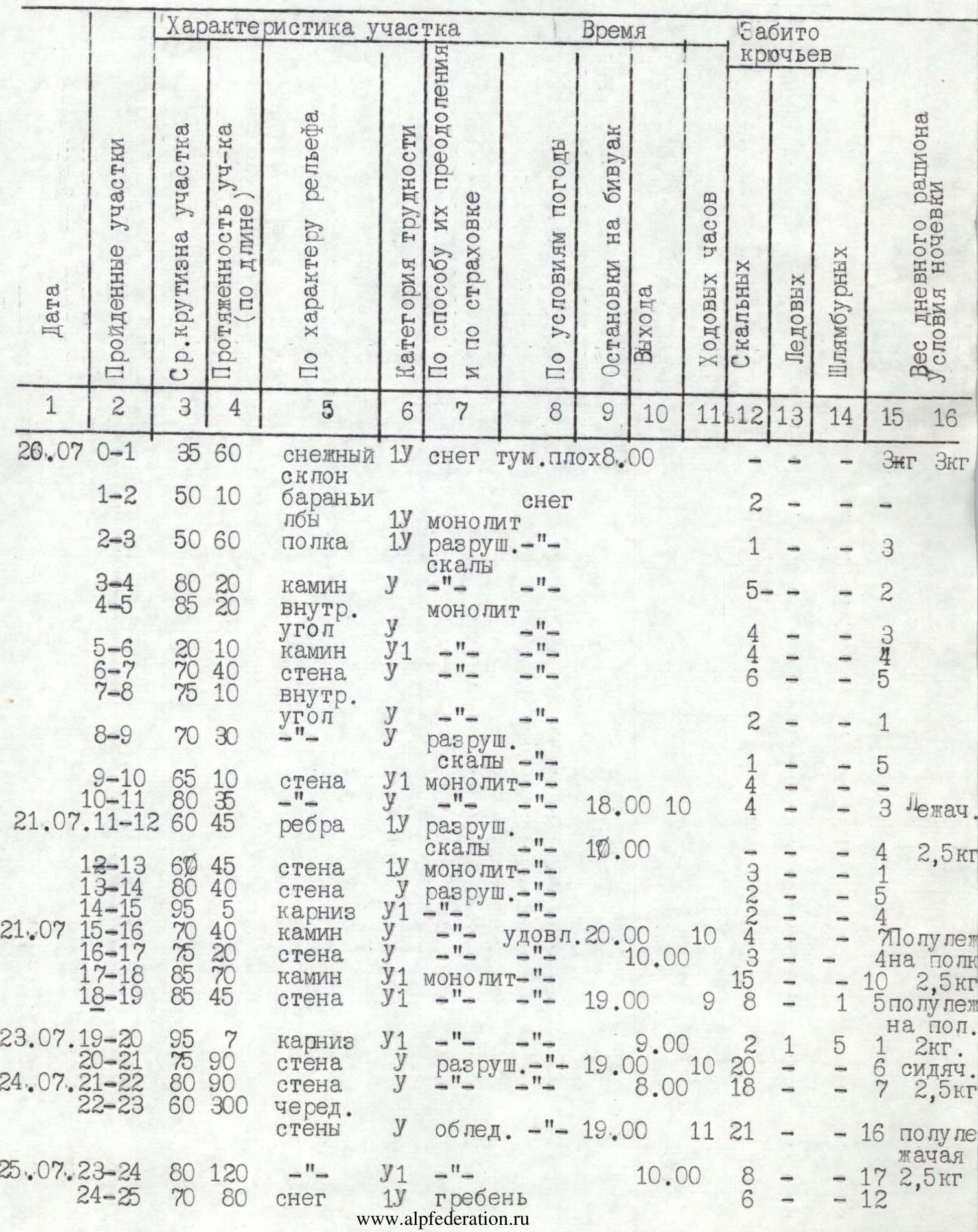
| Date | Sections covered | Average steepness of section | Length of section (by length), m | By terrain character | Category of difficulty | By method of overcoming and belay | Weather conditions | Bivouac stops | Departure | Climbing hours | Rock | Bolt | Ice | Daily ration weight, kg | Overnight conditions |
|---|---|---|---|---|---|---|---|---|---|---|---|---|---|---|---|
| July 20 | R0–R1 | 35 | 60 | snow slope | 1 | snow | fog, poor | 8:00 | Eng 3 | ||||||
| R1–R2 | 50 | 10 | "ram's foreheads" | 1 | snow | 2 | |||||||||
| R2–R3 | 50 | 60 | ledge | 1 | loose rock | -"- | 1 | 3 | |||||||
| R3–R4 | 80 | 20 | chimney | 1 | -"- | 5 | — | — | 2 | ||||||
| R4–R5 | 85 | 20 | inner corner | 1 | monolith | 4 | 3 | ||||||||
| R5–R6 | 20 | 10 | chimney | 1 | -"- | 4 | 1 | 4 | |||||||
| R6–R7 | 70 | 40 | wall | 1 | -"- | 6 | 5 | ||||||||
| R7–R8 | 75 | 10 | inner corner | 1 | -"- | 2 | |||||||||
| R8–R9 | 70 | 30 | wall | 1 | loose rock | 1 | |||||||||
| R9–R10 | 65 | 10 | wall | 1 | monolith | -"- | 4 | 3 | Lying | ||||||
| R10–R11 | 80 | 35 | wall | 1 | -"- | -"- | 18:00 | 10:00 | 4 | 4 | 2.5 | ||||
| July 21 | R11–R12 | 60 | 45 | ridges | 1 | loose rock | -"- | 10:00 | |||||||
| R12–R13 | 60 | 45 | wall | 1 | monolith | -"- | 3 | 1 | |||||||
| R13–R14 | 80 | 40 | wall | 1 | loose rock | -"- | 2 | 5 | |||||||
| R14–R15 | 95 | 5 | cornice | 1 | -"- | 2 | 4 | ||||||||
| July 21 | R15–R16 | 70 | 40 | chimney | 1 | satisfactory | 20:00 | 10:00 | 4 | 4 | Semi-reclining 4 on ledge | ||||
| R16–R17 | 75 | 20 | wall | 1 | -"- | 10:00 | 3 | 10 | 2.5 | ||||||
| R17–R18 | 85 | 70 | chimney | 1 | monolith | -"- | 15 | 1 | 5 Semi-reclining on ledge | ||||||
| R18–R19 | 85 | 45 | wall | 1 | -"- | 19:00 | 9:00 | 8 | 5 | ||||||
| July 23 | R19–R20 | 95 | 7 | cornice | 1 | -"- | -"- | 9:00 | 2 | 1 | 2 | ||||
| R20–R21 | 75 | 90 | wall | 1 | loose" rock | -"- | 19:00 | 10:00 | 20 | 6 | Sitting 7 2.5 | ||||
| July 24 | R21–R22 | 80 | 90 | wall | 1 | -"- | 19:00 | 10:00 | 18 | ||||||
| R22–R23 | 60 | 300 | alternate walls | 1 | icy | -"- | 19:00 | 11:00 | 21 | 1 | 16 | Semi-reclining 17 2.5 | |||
| July 25 | R23–R24 | 80 | 120 | -"- | 1 | -"- | -"- | 10:00 | 17 | ||||||
| R24–R25 | 70 | 80 | snow | 1 | ridge | 8 | 6 | — | 12 | ||||||
| July 25 | R25–R26 | 90 | 20 | wall | 1 | icy rock | 6 | — | — | 3 | |||||
| R26–R27 | 90 | 40 | wall | 1 | monolith | 4 | 11 | ||||||||
| R27–R28 | 70 | 80 | inner corner | 1 | icy rock | 5 | 4 | ||||||||
| R28–R29 | 60 | 20 | slab | 1 | snow, ice | 3 | 1 | 2 | |||||||
| July 26 | R29–R30 | 70 | 40 | snow | 1 | ridge | -"- | 3 | 4 | ||||||
| R30–R31 | 70 | 40 | snow | 1 | -"- | 3 | 1 | ||||||||
| R31–R32 | 95 | 10 | cornice | 1 | monolith | 4 | 1 | ||||||||
| R32–R33 | 60 | 20 | wall | 1 | icy | 23:00 | 3 | 2 | Sitting 1 2.5 | ||||||
| July 26 | R34–R35 | 90 | 10 | wall | 1 | icy | 10:00 | 2 | 1 | ||||||
| R35–R36 | 70 | 40 | ice | 1 | couloir | 4 | 3 | ||||||||
| R36–R37 | 90 | 30 | wall | 1 | loose rock | 3 | 3 | ||||||||
| R37–R38 | 95 | 10 | cornice | 1 | -"- | 4 | 2 | ||||||||
| R38–R39 | 60 | 20 | wall | 1 | icy | 3 | 4 | ||||||||
| R39–R40 | 70 | 20 | snow | 1 | ridge | 5 | 2 | ||||||||
| cornices | |||||||||||||||
| R40–R41 | 110 | 10 | wall | 1 | snow, ice | 7 | 3 | ||||||||
| R41–R42 | 45 | 40 | ridge | 1 | snow, ice | 20:00 | 10:00 | 2 | Semi-reclining 2.5 | ||||||
| July 27 | R42–R43 | 45 | 270 | ridge | 1 | snow, ice | 8:00 | 6 | — | — | 1 | ||||
| R43–R44 | 60 | 120 | ridge | 1 | snow, ice | 6 | — | — | 1 | ||||||
| R44–R45 | 45 | 30 | ridge | 1 | snow, ice | 3 | |||||||||
| R45–R46 | 70 | 25 | wall | 1 | monolith | 3 | 2 | ||||||||
| R46–R47 | 70 | 30 | inner corner | 1 | icy | 5 | — | — | 3 | ||||||
| R47–R48 | 85 | 50 | wall | 1 | monolith | 18 | 3 | ||||||||
| R48–R49 | 75 | 50 | ridge | 1 | snow, ice | 6 | 4 | — | 2 | ||||||
| R49–R50 | 70 | 30 | ridge | 1 | snow, ice | 4 | 1 | — | 1 | ||||||
| R50–R51 | 75 | 50 | wall | 1 | monolith | 10 | 10 | — | 4 | ||||||
| R51–R52 | 90 | 25 | cornice | 1 | monolith | 4 | |||||||||
| R52–R53 | 20 | 100 | ridge | 3 | snow, ice | 4 | |||||||||
| Summit | 17:00 | 9:00 | 20 |
Brief explanation of the table
Section R0–R1. Approach to the rocky part of the route. Steep snow slope with a wide bergschrund. Path through the bergschrund via fragile snow bridges.
Section R1–R5. Alternating walls and inner corners. Passage complicated by poor weather conditions: fog, wet snow.
Section R5–R6. Chimney with a plug, passed straight up through the plug. Highly polished wet rocks. Mainly petal pitons are used.
Section R6–R9. Monolithic rocks. Climbing is complex, with wet snow falling and strong wind.
Section R9–R10. Wall with highly polished rocks and a huge number of holds. Practically no places for belay.
Section R10–R13. Wall and vaguely defined ridges. Rocks are wet. Snow, strong wind.
Section R13–R15. Loose wet rocks, overhanging in the upper part. Holds are inconvenient, with a low grip. Cornice bypassed to the right with free climbing. Then exit to a ledge.
Section R15–R17. On the ledge, traces of the first ascenders' overnight stay were found. From the ledge, via an inner corner, a crack, and a wall suitable under a large chip. Climbing is complex. The path via the crack leading to the right was abandoned due to stones falling from the edge. The inner corner is protected by a cornice.
Section R17–R18. Very steep, partly overhanging inner corner. Practically no places for driving pitons. Nuts of various types are used. Overcome using I.T.O. and the full arsenal of pitons and nuts. After the wall, exit under a cornice.
Section R19–R20. Key section of the route, representing a cornice with a large overhang. There are no cracks on the cornice, and bolt pitons have to be used. After exiting onto the cornice, an inner corner is passed straight up. Then steep "ram's foreheads" are traversed to the left using "skyhooks".
Section R20–R21. Steep wall, loose rocks. Difficult to organize a belay point. Climbing is complex.
Section R21–R24. A system of alternating walls leads to an edge, icy rocks. Climbing is complicated by a large amount of wet, loose snow lying on the rocks.
Section R24–R25. Snow-ice ridge with cornices. Difficulty with organizing belay.
Section R25–R27. Very steep rocky wall covered with rime ice. Very difficult to organize belay points. Partly overhanging snow cornices.
Section R27–R33. Alternating walls and inner corners. Partly overhanging. Climbing is complex: icy rocks, large snow drifts. Under the layer of snow — abundance of "live" stones.
Section R33–R41. Wall covered with rime ice. Climbing is complex. In the upper part — sections of loose deep snow lying on icy rocks. Exit to the ridge via a large snow cornice.
Section R42–R53. Movement along the ridge. Heavily snow-covered rocks alternating with ice ridges. Very often snow cornices and drifts are encountered. The summit is heavily snow-covered. The tour on the intermediate summit is destroyed. The note of the first ascenders was not found.
Protocol for the analysis of the ascent to Peak Skalisty, Southeast summit 5450 m, via the Southeast wall of the South ridge, 6B category of difficulty.
Present:
- 1st releasing MS Pavlenko K.V.
- Head of rescue CMS Rabinov F.G.
- Bashmakov M.I. — leader
- Arsentyev S.A.
- Konovalov Yu.V.
- Mozhaev M.V.
- Solovyov S.A.
- Shpynev G.P.
- and the entire personnel of the gathering.
- Bashmakov M.I.
We left the camp for the route on July 20. There were 7 overnight stays on the route. On July 27, we reached the summit of Peak Skalisty 5450 m at 10:45. We descended to the base camp on July 28 at 9:00.
- 1st overnight stay was in the bergschrund.
- Initially, 5 ropes were processed.
- We reached a large ledge under a characteristic protrusion.
- Climbing 4–5 category of difficulty.
- Mozhaev M.V. worked first.
- Overnight stay was lying, with snow.
After the ledge, we moved up, towards the chip, aiming to the right of the chip. We were hit by stones falling from the edge. Passing the chip and the cornice above it is technically much more complex but safer.
On July 22, we passed the sections processed on July 21. 3 ropes, another 2, and we approached under the cornice.
- Arsentyev S.A. worked first.
- Overnight stay on the same ledge.
On July 23, we passed the cornice and approached under the rib.
- Solovyov S.A. worked first.
- Rocks 5–6 category of difficulty.
- Overnight stays were uncomfortable, scattered.
The entire wall section of the route is stone-hazardous, especially from 12:00 to 16:00.
July 24
- We reached the rib and passed 10 ropes.
- Rocks were icy.
- We camped on a snow-packed platform.
July 25
- Continued movement along the rib.
- Rocks were icy, with many snow drifts.
July 26
- We reached the ridge.
- Upon exiting — large snow drifts, climbing was difficult.
- Ridge was easy, 3 category of difficulty.
- We camped on a good ledge after a rappel.
July 27
- We reached the summit at 16:45 and began descent at 17:40.
July 28
- We arrived at the base camp.
- We didn't find a tour on the summit because the ridge was snow-covered.
On the participants:
- Leader: I am satisfied with all participants of the ascent, there are no significant remarks. Regular communication with the observation group was maintained throughout the ascent.
- Konovalov Yu.V.: This is my first ascent of 6B category of difficulty. I am satisfied with the ascent and participants. Relationships among comrades were good. Leadership was competent in all respects. I would like to note the good, varied nutrition.
- Mozhaev M.V.: I would especially like to note the stone hazard of the wall section of the route and the difficulty of passing snow-covered sections on the rib.
- Shpynev G.P.: This is my first ascent of 6B category of difficulty, the longest in terms of time. I believe this route corresponds to 6B category of difficulty. Despite the harsh weather conditions, the team climate was favorable. I really liked Bashmakov M.I.'s leadership.
- Solovyov S.A.: This is my most difficult ascent of 6B category of difficulty. Compared to previous ascents of 6B category of difficulty, this one deserves a higher rating.
- 1st releasing Pavlenko K.V.: The ascent was carried out competently, without violations. I acknowledge the leadership of Bashmakov M.I. and the participation of all ascenders.
1st releasing
secretary

Pavlenko K.V. Golubtsov S.G.