
PASSPORT
1. Category — technical.
- Region — PAMIR-ALAY, Ak-Terek spur of the Turkestan Range.
- SCALISTY Peak, SOUTHEASTERN summit — 5450 m, via the eastern wall of the Southern ridge.
- Proposed 6B category of difficulty, FIRST ASCENT.
- Height difference — 1610 m, length 2275 m.
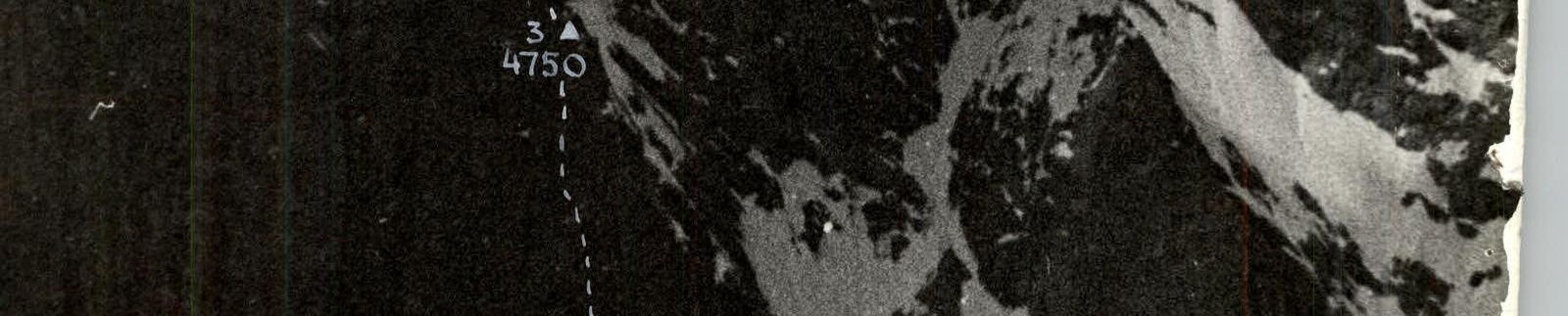
Length of sections with 5–6 category of difficulty — 1847 m. Average steepness of main sections — 84° (4100–4750 m), 72° (4750–5280 m), 74° (5150–5450 m), of which 6th category — 847 m: 86° (502 m) 4100–4750 m, 77° (265 m) 4790–5250 m, 85° (80 m) 5250–5410 m.
- Number of pitons driven:
| rock | placements | bolted | ice | |
|---|---|---|---|---|
| total | 259 | 137 | 2 | 26 |
| of which I.T.O. | 36 | 49 | 0 | 6 |
-
Team's total hours: 72, days: 6.
-
Overnight stays:
- 1st on a rock-ice ledge in tents;
- 2nd sitting bivouac for four, one in a hammock, on three levels in a chimney;
- 3rd sitting on iced slabs;
- 4th sitting on an ice ledge, carved on an ice "knife";
- 5th lying in tents on a snowy ridge.
-
Team Leader: GOLUBEV Nikolay Nikolayevich, Master of Sports. Participants:
- NOSOV Anatoly Pavlovich, Master of Sports of International Class
- FEDOTOV Yury Nikolayevich, Master of Sports
- ZHAK Victor Vladimirovich, Master of Sports
- GLUSHKOV Alexander Semenovich, Candidate for Master of Sports
-
Coach: DZHIrayev Yury Georgievich, Master of Sports.
-
Approach to the route on July 17, 1982, summit — July 22, 1982, return — July 23, 1982.
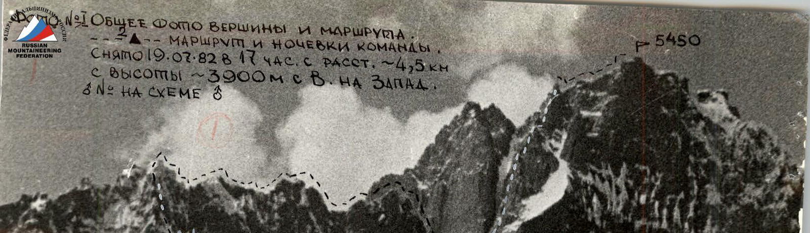
N:1 GENERAL PHOTO OF THE SUMMIT AND THE ROUTE
ZA — THE ROUTE AND THE TEAM'S OVERNIGHT STAYS.
Taken on 19.07.1982 at 17:00 from a distance of ~4.5 km
from a height of ~3900 m from east to west.
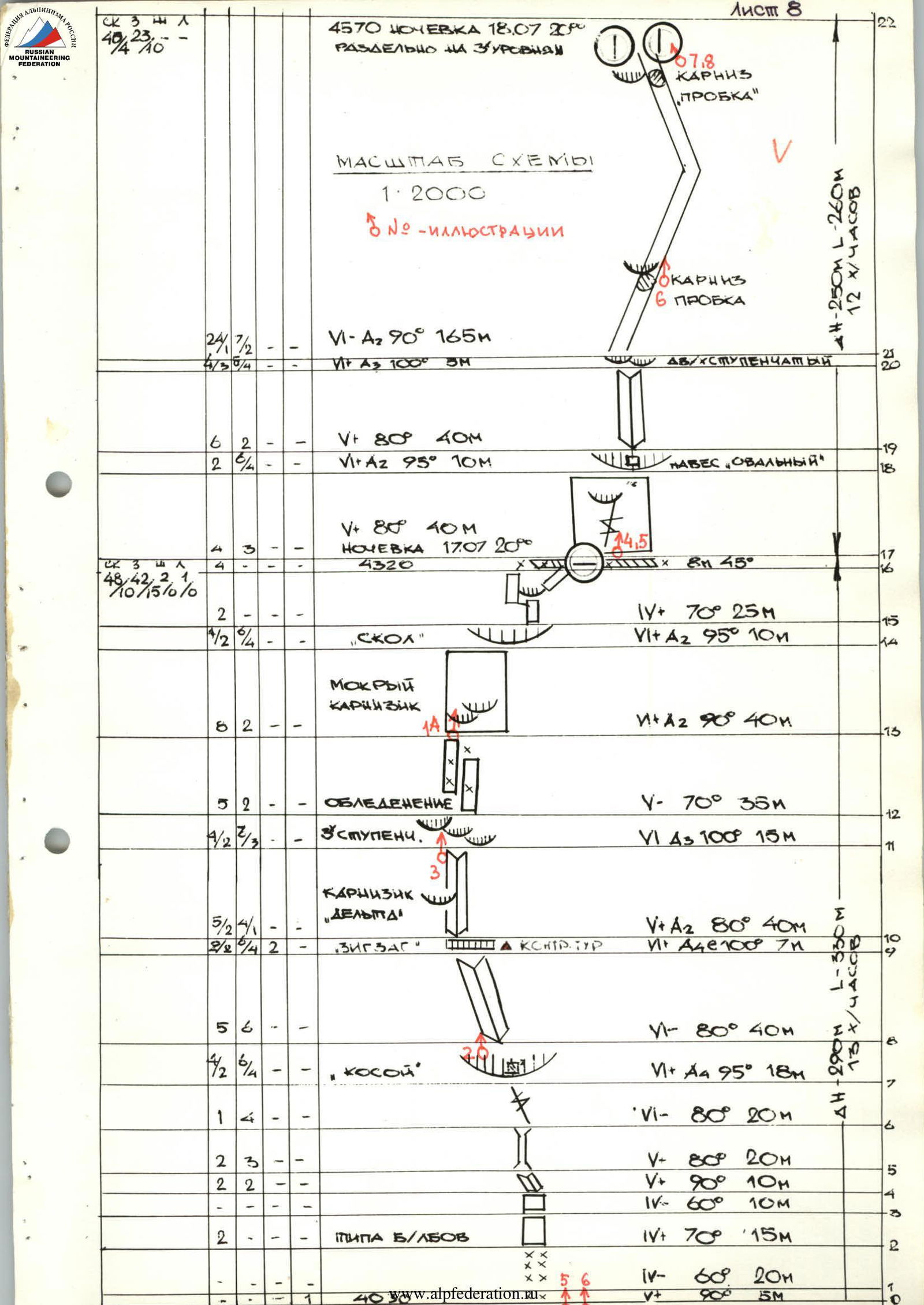
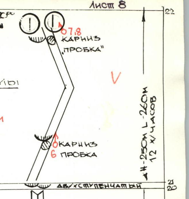
№ on the diagram 8
N:1 PHOTOPANORAMA OF THE REGION. VIEW FROM EAST TO WEST. ROUTES, SUMMITS
Taken on 19.07 at 17:00 from a height of 3900 from a distance of 4.5–5 km F=50 mm
On diagram N V
See PHOTOPANORAMA FROM THE WEST in the supplement /TEAM DESCENT/
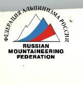
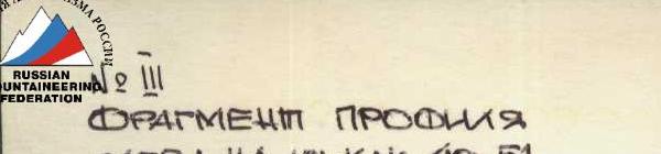
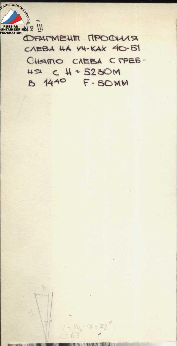
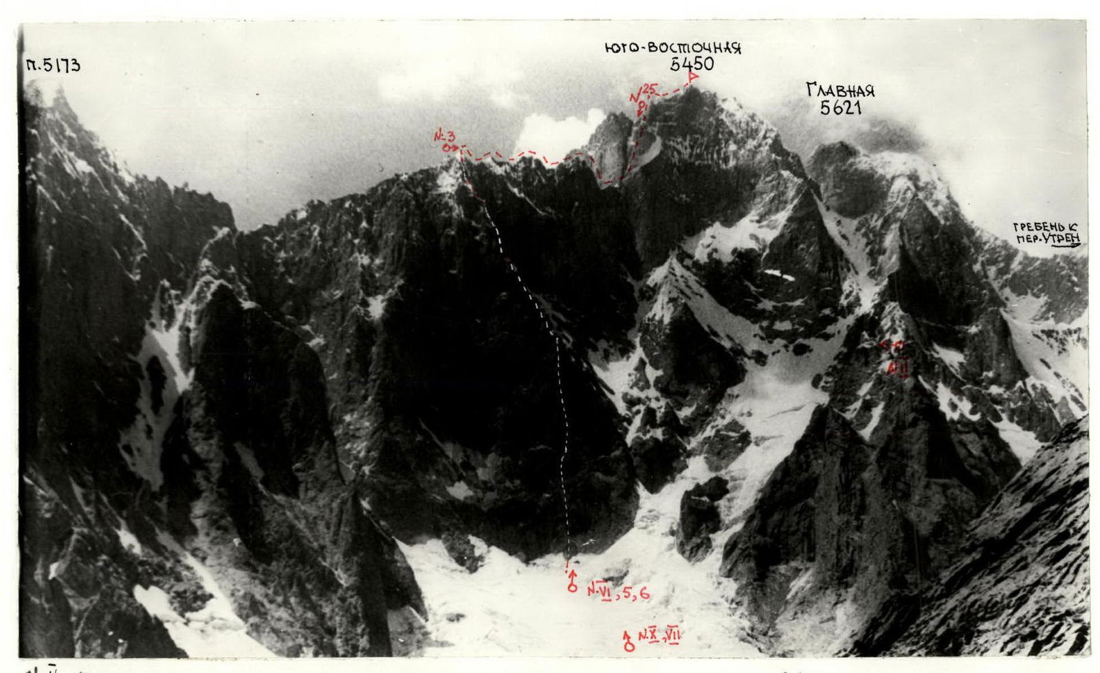 №3 PHOTO OF THE PROFILE FROM THE RIGHT № // taken from the NORTH from a height of 4500 ~1500 m
from a distance of ~2 km F=50 mm ON DIAGRAM N.
DUE TO THE HEIGHT OF THE SHOOTING POINT, THE LOWER PART IS SHORTENED.
--- THE ROUTE AND OVERNIGHT STAYS
№3 PHOTO OF THE PROFILE FROM THE RIGHT № // taken from the NORTH from a height of 4500 ~1500 m
from a distance of ~2 km F=50 mm ON DIAGRAM N.
DUE TO THE HEIGHT OF THE SHOOTING POINT, THE LOWER PART IS SHORTENED.
--- THE ROUTE AND OVERNIGHT STAYS
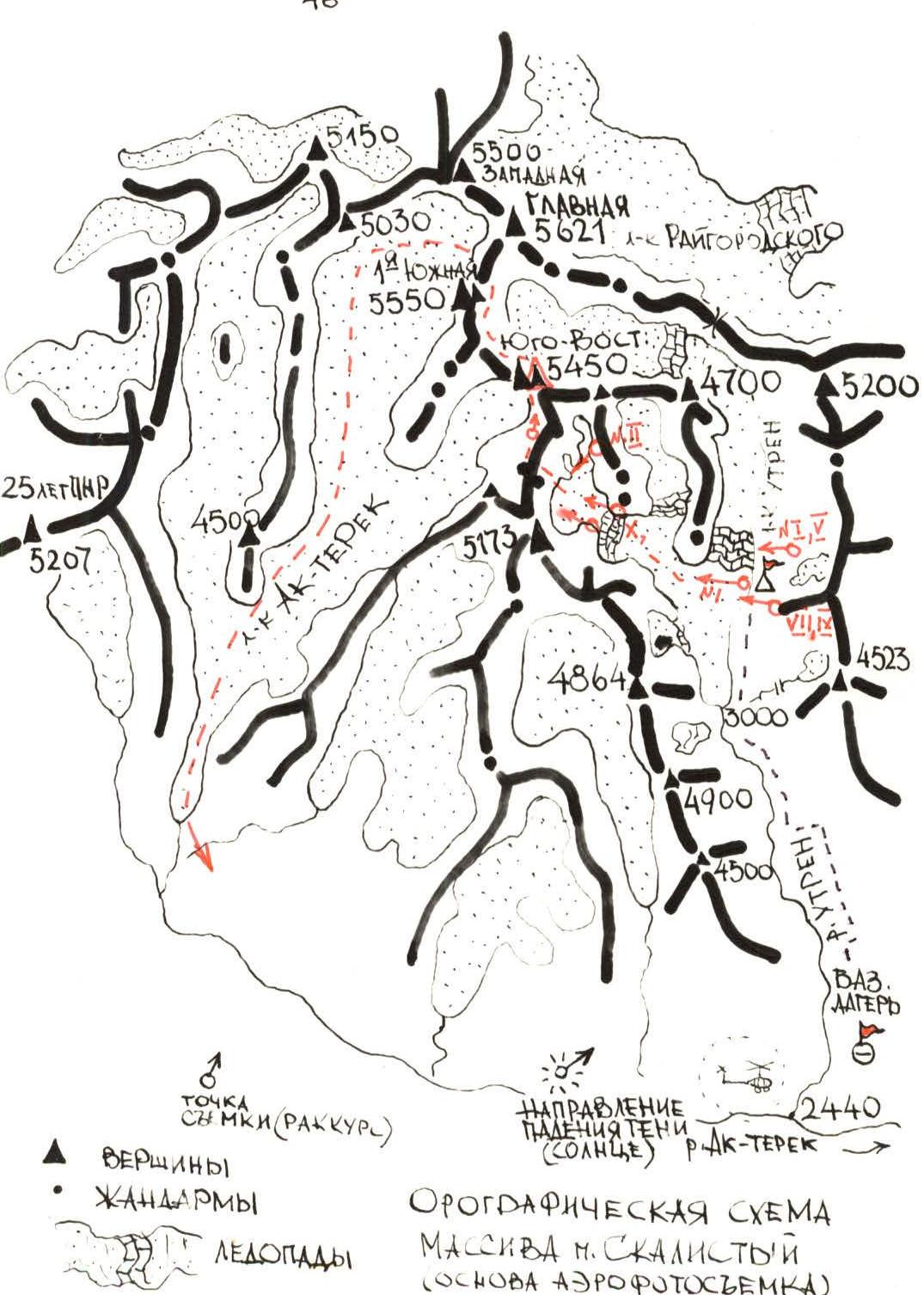
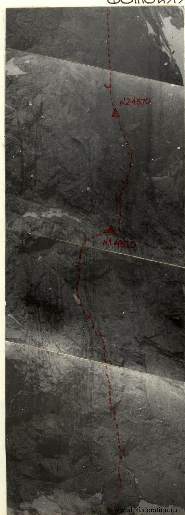
 №2 REFINED DIAGRAM OF THE REGION
/ BASED ON EXPEDITION MATERIALS
AND AERIAL PHOTOGRAPHY /
NOTATIONS
N LOCATIONS OF SHOTS AND PHOTO ILLUSTRATIONS
M 1:100000/TAKING INTO ACCOUNT THE ANGLE OF AERIAL
PHOTOGRAPHY/
№2 REFINED DIAGRAM OF THE REGION
/ BASED ON EXPEDITION MATERIALS
AND AERIAL PHOTOGRAPHY /
NOTATIONS
N LOCATIONS OF SHOTS AND PHOTO ILLUSTRATIONS
M 1:100000/TAKING INTO ACCOUNT THE ANGLE OF AERIAL
PHOTOGRAPHY/
 N. IV FRAGMENT OF THE PROFILE
FROM THE LEFT ON SECTIONS 26–29
Taken from the ROUTE
FROM SECTION 27 ~15:00
N. IV FRAGMENT OF THE PROFILE
FROM THE LEFT ON SECTIONS 26–29
Taken from the ROUTE
FROM SECTION 27 ~15:00
 TOTAL HOURS — 72
TOTAL NUMBER OF DRIVEN PITONS ROCK Z SH L
259 157 2 26
/36 /49 /0 /6
TOTAL HOURS — 72
TOTAL NUMBER OF DRIVEN PITONS ROCK Z SH L
259 157 2 26
/36 /49 /0 /6
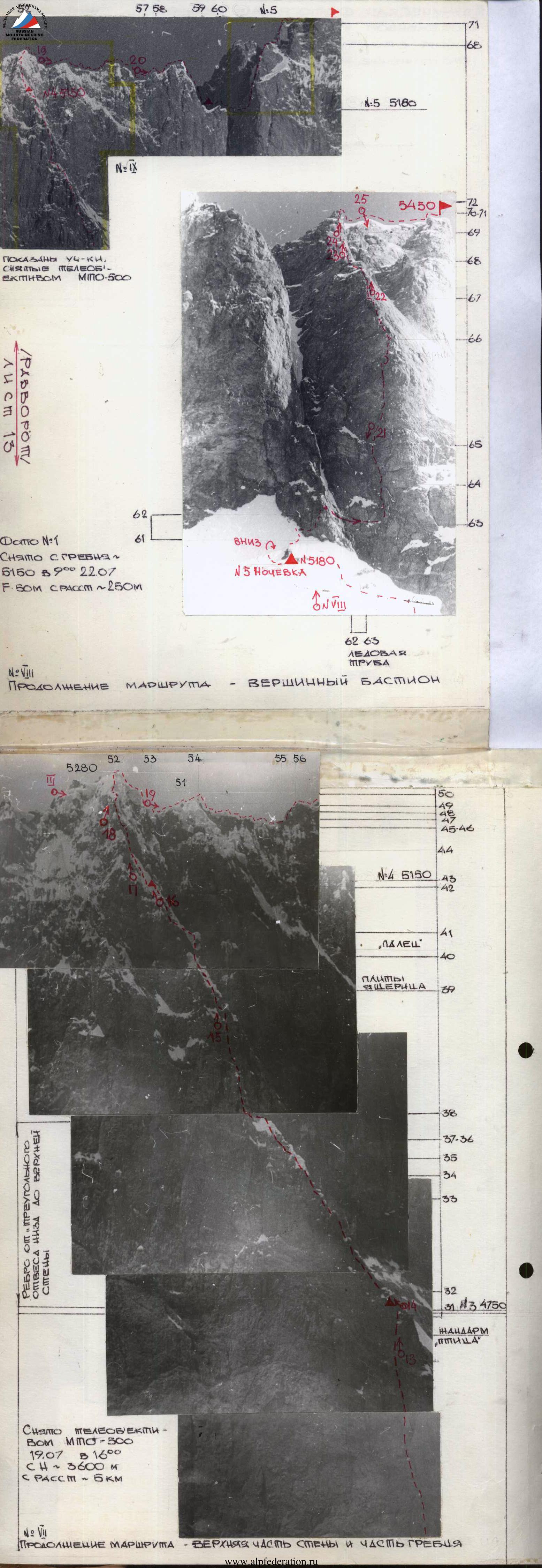
 №6 Sections 16–22 /4 PARTICIPANTS visible / Taken from the GLACIER SN-3800M
18.07 with a telephoto lens MPO-500 from a distance of 0.6 km at 15:00
/SEE LOGBOOK
№6 Sections 16–22 /4 PARTICIPANTS visible / Taken from the GLACIER SN-3800M
18.07 with a telephoto lens MPO-500 from a distance of 0.6 km at 15:00
/SEE LOGBOOK
Brief Overview of the Ascent Region
The object of our ascent is located northeast of Igla Peak 4730 m, in the Ak-Terek spur of the Turkestan Range in the Scalisty massif. This is the highest massif of the entire Pamir-Alay.
The approach is made from the city of Isfara (Tajik SSR) to the village of Zardaly (by car) — 5 hours; then by caravan along the Ak-Terek river valley (25 km), 6–7 hours, to the confluence of the Utren river on the left (forest, glades); then in the Utren gorge to the left-bank moraine (2.5 hours, streams, platforms, grass). Other paths to the object are possible through neighboring passes: per. Aylyanysh 2B category, North Tutek 2A category, per. Yashil-kul 2A category — Alay Range, from the village of Khait 50 km; per. Utren 3B category and per. Ivanova 2A category through the Turkestan Range, but these paths exclude the use of pack transport.
The eastern walls of the Ak-Terek spur rise above the Utren glacier (Ak-Terek basin) by 1200–1500 meters with monolithic granite walls. The highest point of the ridge is Scalisty Peak Main (5621 m). To the southwest and southeast of it are the ridge's summits in the following order:
- 1st Southern — 5550 m (double);
- Southeastern — 5450 m (double).
Further, the serrated Southern ridge of the Southeastern summit leads to the massif of peak 5173 and then to peak 4864 m. To the south, the spur carries the summit 4900 m. From the Utren glacier side, the Ak-Terek spur summits, according to our information, have not been visited by climbers. Fed by falls from the walls of p. 5450 and p. 5173, a short but powerful lateral glacier flows into the Utren glacier in its middle course (below the icefall) on the right. The eastern wall of the Southern ridge of the Southeastern summit of the Scalisty massif is situated above this glacier. The wall is lit by the sun from 7:00 to 16:00; usually, from 16:00 to 19:00, precipitation falls, creating a strong ridge snow cover and peculiar cap-like snow-ice formations on the wall and relief, and water flows in the lower part.
The Scalisty massif is in a cloud cap in the evening and probably has its own microclimate. The 1982 season was extremely rainy, especially in the second half of June and the first half of July, but the team managed to catch an 8-day "window" of good weather after 14 days of waiting.
The eastern walls of the Ak-Terek spur are composed of granites in their lower half, with marblized limestones and sedimentary rocks above. In the cirque of the aforementioned glacier, it is possible to lay out about 20 routes of 5B category, indicating the steepness and length of the surrounding walls.
Neighboring gorges (North Tutek, Matcha, Darapioz) are also of great interest to climbers; many 5B category routes can be laid out there.
Movement was carried out according to a schedule that ensured the implementation of the tactical plan and safety on the route: 12–13 working hours and 8 hours of night rest. (The schedule was determined by the physical and technical preparedness of team members). The route took 72 working hours. The work of the lead climber was done without a backpack on a double rope. The transfer of backpacks (4 pieces) was carried out on oneself while moving along fixed ropes. The team is well-coordinated, and the specialization of each member on a particular terrain was taken into account to the maximum. Leads: Glushkov (sections R6–R16, R23–R28, R66–R72); Nosov (sections R17–R23); Zhak (sections R31–R42); Golubev (sections R42–R60); Fedotov (sections R0–R6, R28–R31, R60–R66). The lead climber typically works a full day.
Bivouac equipment is designed for joint and separate overnight stays, including sitting and hanging (tent-hammocks), so the primary principle of choosing overnight stays was their safety. Overnight stays:
- 1st lying under the shelter of section R17;
- 2nd separate (at a rope's distance), hanging and sitting in the "integral" chimney, under the cover of a huge overhanging "drop" cornice section R22, photo 18;
- 3rd separate, on ledges, sitting section R31, photo 14;
- 4th sitting, on an ice "trough" carved in ice section R42, photo 16;
- 5th lying, on a snowy ridge section R60.
The entire route was completed in 6 days (5 overnight stays) without prior processing, which corresponds to the tactical plan.
First day — July 17. The main task is to pass the 1st belt of the wall — the "triangular sheer". Problematic sections: R7–R8 "oblique cornice"; R9–R10 "zigzag cornice"; R11–R12 "three-step cornice"; R14–R15 "flake" cornice. The passage of these sections was carried out, as a rule, using I.T.O., on pitons and placements, double rope "Zaltsuga" and the "piton-legs" device, on section R9–R10, 2 bolted pitons were used (photos).
Second day — July 18. The main task is to choose a variant for passing the 2nd belt of the wall.
- 1st team goes out to choose a route to the right of the "integral" chimney under the cornice (or to the left in the "finger" zone);
- 2nd team adjusts the path of the 1st team from below;
- 2nd team's exit on the ropes — after the final choice of the path.
Overnight stay was planned above the "drop" cornice. Deviation from the tactical plan: overnight stay №2 was organized below the "drop" cornice. This was due to the danger of passing it in the second half of the day (stones in water streams). The 1st pair, having hung ropes to the cornice section R22, descended on a rope where they met the "3rd" pair. Here the team organized a hanging overnight stay on three levels. Overcoming the "drop" cornice was postponed to the morning, i.e., to a safer time.
Third day — July 19. The main task is to reach the "edge" (conditionally named from below) of the wall under its upper part. Problematic sections: R23–R25, passage of the U-shaped cornice and the chimney above it (R26–R30), icy steep ascents. Solution: the huge "drop" cornice was passed early in the morning using I.T.O. and "piton-legs" (photos 9, 10, 11).
Fourth day — July 20. The main task: reaching the ridge. Problematic sections R31–R42 — a cascade of steep snow-ice "knives" ("gopher", "camel", "lizard", "snake" — named from below) and icy vertical walls and walllets. Solution: spherical formations of ice and snow stuck to the sheer terrain of the upper part of the wall required great "creative" imagination when passing and organizing insurance on these rare forms of snow-ice relief. Insurance was organized in places cleared of ice crust (on rock pitons) or through internal "frame" icicles under the ice crust (with a loop of rep cord).
Fifth day — July 21. The main task: passage of the ridge and choice of a variant for passing the pre-summit tower (bastion). Problematic sections R47–R51 — huge snow-ice caps, cornices, and icicles at the junction of the eastern wall and the Southern ridge. Solution: 1st — Golubev (on crampons) cut an ice "hoop" on the ridge, successfully bypassed a three-meter overhang of ice cornices (photo 18).
Sixth day — July 22. Exit to the summit. Problematic sections: at the base of the summit bastion, the path was blocked by a giant vertical "chimney" with an icefall — "ice pipe", section R62–R63, 20 m wide; on the summit bastion — a sheer 25-meter icy chimney section R69–R71, at an altitude of 5400 m. Solution: the "ice pipe" was passed early in the morning with the help of a "20-meter pendulum".
The path to the aforementioned chimney was chosen on the left side of the bastion; it is steep but safe. Everything to the right is interspersed with avalanches and falls along the outer ledge, steeply descending from under the summit. The first person chiseled ice in the chimney in search of cracks (photo 24). In bad weather — sections R16–R17, R35–R40, R68–R72 — the team increased the "safety margin".
The team maintained constant radio contact with observers. Observers daily reported weather forecasts and changes in the wall's condition (waterfalls, falls, cloudiness) and the group's location. The team daily at 20:00 reported to observers their height, landmarks, their condition, and the wall's condition. Observers saw participants on the route through binoculars (x12) for all 6 days (same judge Gorenchuk Yu.F.). Below was a safety group (11 climbers) with a specific action plan for an extreme situation.
№7 Section 22 GOLUBEV
ON A HANGING OVERNIGHT STAY
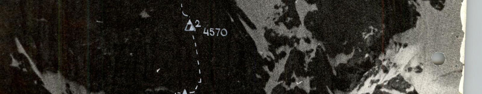
№2/4570 m/ IN THE "INTEGRAL" CHIMNEY Taken
18.07 at 20:30 F=50 mm
 N:8 Section 22. NOSOV IN A HAMMOCK, GLUSHKOV SITS ON OVERNIGHT STAY №2 /4570 m/.
ABOVE, THE "DROP" CORNICE IS VISIBLE. Taken from below, from the level of Golubev's overnight stay, 18.07 at 20:30 F=50 mm
N:8 Section 22. NOSOV IN A HAMMOCK, GLUSHKOV SITS ON OVERNIGHT STAY №2 /4570 m/.
ABOVE, THE "DROP" CORNICE IS VISIBLE. Taken from below, from the level of Golubev's overnight stay, 18.07 at 20:30 F=50 mm
 N:25 VIEW DOWN ON THE WALL PROFILE FROM THE SUMMIT BASTION FROM SECTIONS 67–69
 N:24 Sections 69–70 GLUSHKOV
WORKS IN THE UPPER CHIMNEY. Taken
from section 69 22.07 at 18:40 F=50 mm
N:24 Sections 69–70 GLUSHKOV
WORKS IN THE UPPER CHIMNEY. Taken
from section 69 22.07 at 18:40 F=50 mm
 №26 VIEW OF THE SCALISTY PEAK MASSIF FROM THE WEST,
SHOWS THE TEAM'S DESCENT ROUTE.
/ PHOTO TAKEN IN 1980 DURING
RECONNAISSANCE OF THE REGION/
DESCENT AROUND THE 1ST SOUTHERN SUMMIT
TO THE AK-TEREK GLACIER.
№26 VIEW OF THE SCALISTY PEAK MASSIF FROM THE WEST,
SHOWS THE TEAM'S DESCENT ROUTE.
/ PHOTO TAKEN IN 1980 DURING
RECONNAISSANCE OF THE REGION/
DESCENT AROUND THE 1ST SOUTHERN SUMMIT
TO THE AK-TEREK GLACIER.
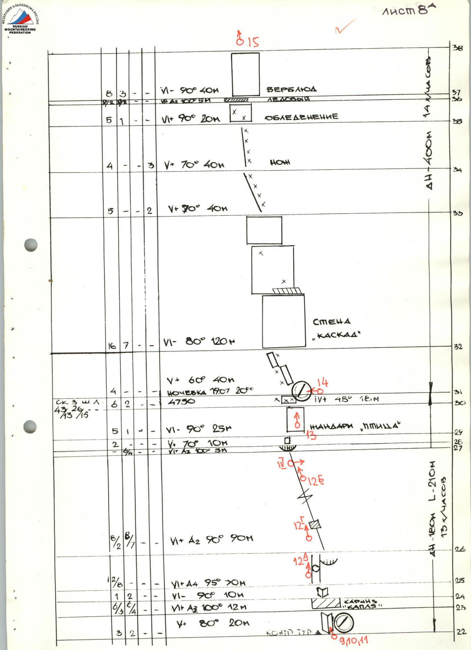
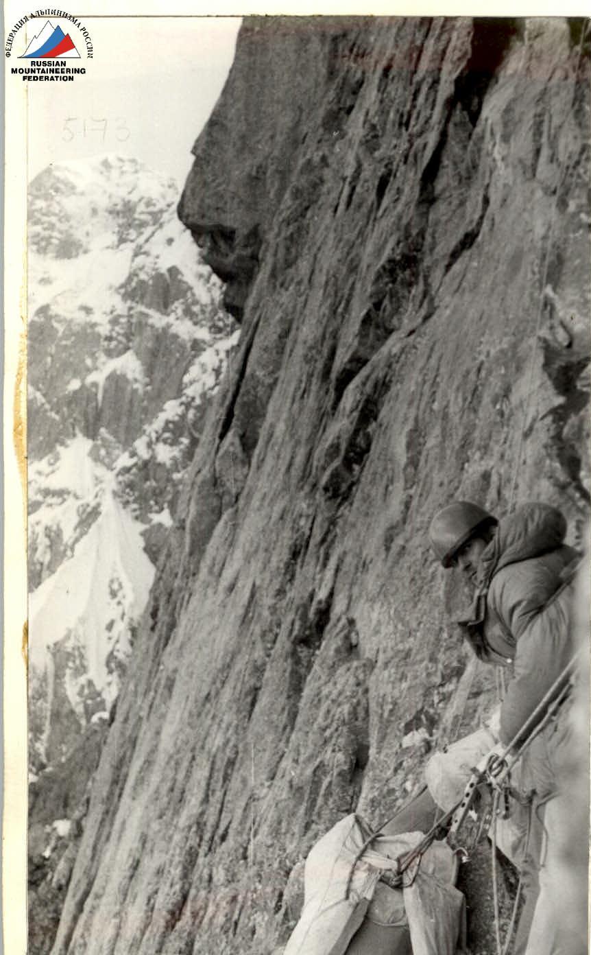
Description of the Route by Sections
Sections R0–R17
1st day — July 17, 1982
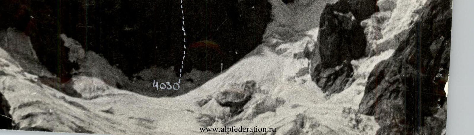
R0–R1: Bergschrund (4030 m) — the far wall of the crevasse rises above the front edge by 5 m. It is crossed via a snow plug located at a depth of 3 meters.
R1–R2: In the morning, ascent on crampons under a slightly protruding "paw" from the wall.
R2–R6: Along rocks like "ram's foreheads", leading to a steep inner corner, and further into a chimney — ascent under the base of the wall with a crack; sections R0–R6 passed by Fedotov Yu.N., then Glushkov A.S. moves first.
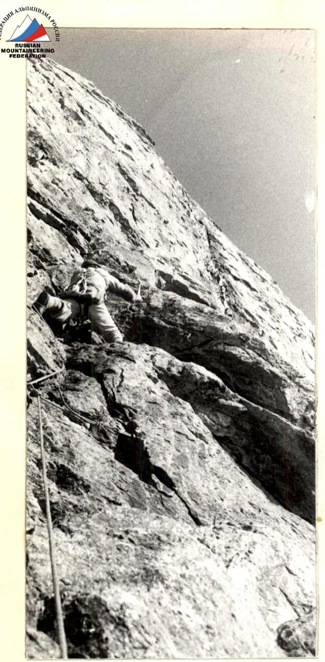
R6–R7: Up the monolithic wall, a crack goes under the first "oblique" cornice. The crack is blunt, with almost no places for pitons and placements.
R7–R8: Through the cornice ("oblique") is a gap — convenient for using placements and pitons.
R8–R9: Along the walls of the inner corner flows water, holds are smoothed — it's done on friction; the corner leads under the "zigzag" cornice, moving left upwards.
R9–R10: In the lower part of the cornice, there are no cracks, we drive 2 bolted pitons under a streaming waterfall. Further, there is a gap for placements and pitons.
R10–R11: From under the cornice upwards and slightly left, along a not clearly expressed inner corner with a crack, movement under the "three-step" cornice.
R11–R12: The cornice consists of three steps of overhangs. There are gaps for placements and pitons.
R12–R15: Movement left — upwards along steep icy slabs, then right-upwards along a wet wall with several overhangs, ending in "flake" cornices. There are gaps for placements and pitons.
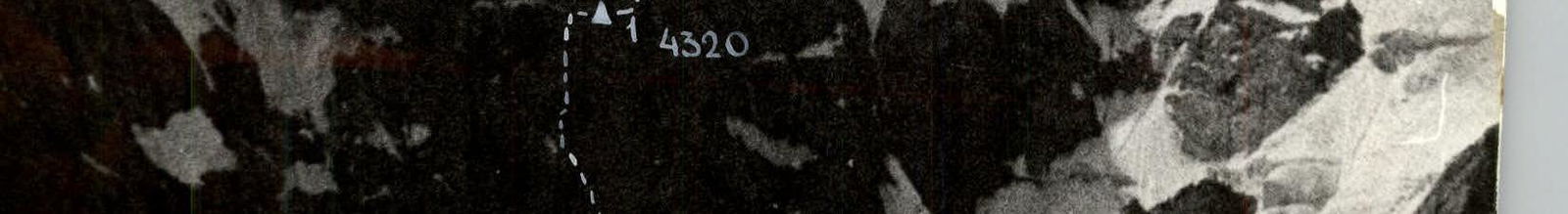
R15–R17: Along destroyed rocks, we exit onto a rock ledge (covered with ice on the left), and along it — a traverse to the right under an overhanging cornice. Under it, having chopped ice, we laid out a stone platform for tents. According to the altimeter — 4320 m. By the end of the day, clothing was soaked from water flows through the cracks. The group worked on ropes. Part of the wall from the bergschrund to the ledge is composed of granites with vertical cracks (often blind) and intersecting "flake" cornices.
2nd day — July 18, 1982
R17–R19: From the overnight stay, 10 m along the ledge and straight up the wall with a crack, ending in a cornice ("oval"). Ahead works A. Nosov. The cornice is passed in stirrups on I.T.O. on the right.
R19–R20: Above the cornice, along a weakly expressed inner corner with a crack — a "two-step" cornice. On I.T.O., traversing to the right-upwards, entrance to a long chimney in the form of a giant "integral". It rests on the "drop" cornice at the top.
R21–R22: The chimney, 1 m wide, goes left-upwards. At the top — a separate overnight stay (hanging in hammocks and sitting), on a plug, under cornices.
3rd day — July 19, 1982
R23–R24: The cornice formed by a jumble of blocks, mostly "live", in the form of a giant "drop" with a huge overhang (I.T.O.).
R24–R26: Inner corner and overhanging chimney with a cornice of very loose rock are passed on I.T.O., taking a lot of time.
R26–R28: 90-meter crack with plugs and a cornice at the top. Bypassing plugs on I.T.O. In the crack — ice accretion.
R28–R30: After the cornice, a steep slab leads to the left edge of a triangular wall with a huge round stone at the top — a "gendarme"-bird. The upper part of the wall is snowy. There are cracks for pitons.
R30–R31: Higher up, 10 m on inclined slabs and "ram's foreheads", we settled for an overnight stay, sitting under the cover of cornices. Snow cover on the rocks — 4750 m. The route of the third and second day passed along the steepest part of the "triangular sheer". Monolithic granites.
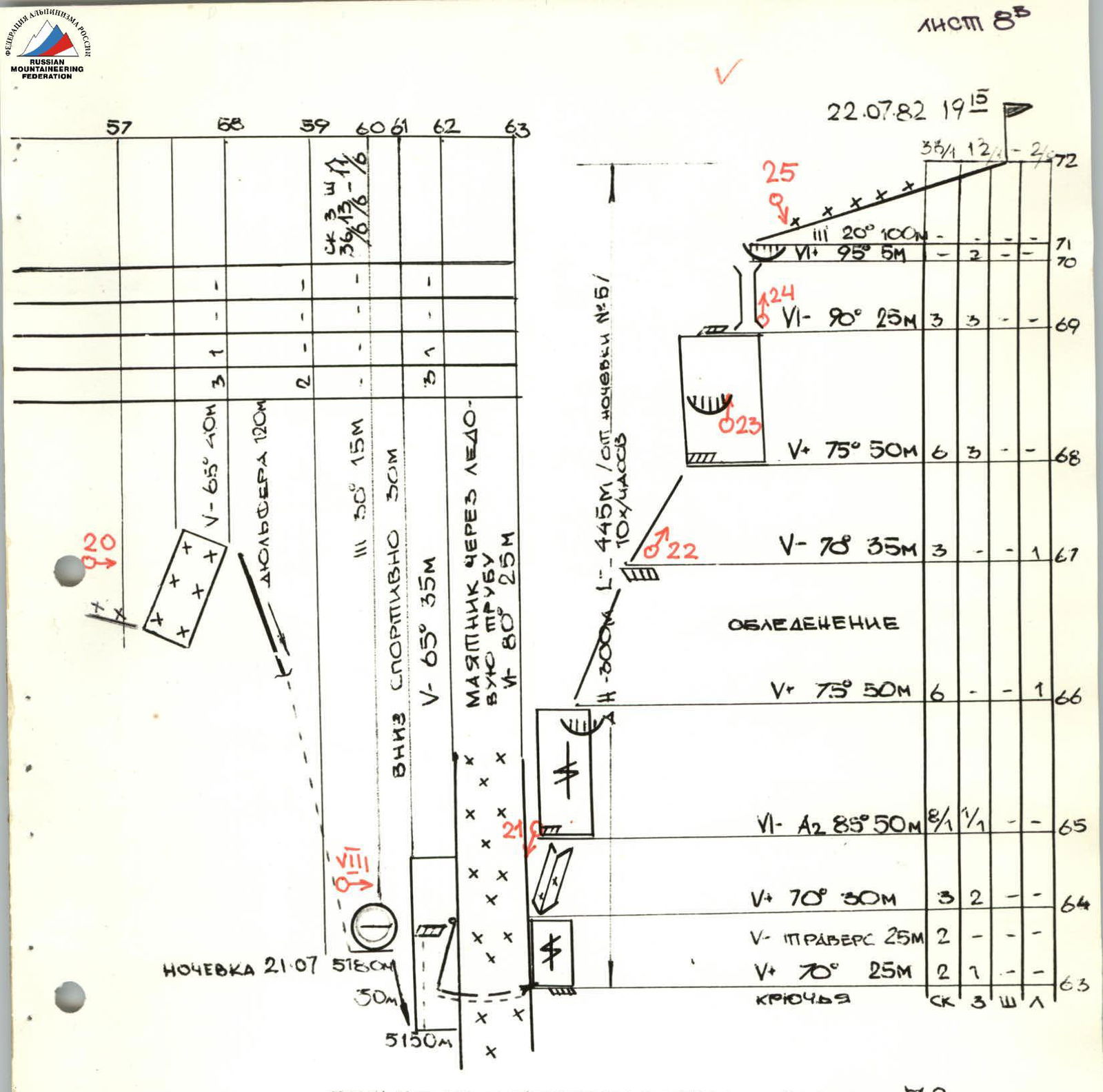
4th day — July 20, 1982
R31–R33: A system of slabs-walls covered with ice, turning into a cascade of three walls. Movement along the middle wall, in a crack.
R33–R35: Snow-ice ridge with rock outcrops in the lower part. Ice is steep at the top. Insurance through ice screws, cutting steps ("gopher").
R35–R38: Icy wall with a cornice-cap in the form of a "camel", with an ice overhang at the top. I.T.O. on ice screws. Ahead — Zhak.
R38–R39: Icy inner corner, after a 40-meter wall. In the corner — ice, icicles hang, cracks are filled with ice.
R39–R40: Ice is covered with a 30–40 cm layer of loose snow, poorly attached to the ice surface ("lizard").
R40–R41: "Finger-column".
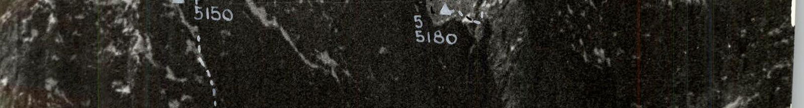
R41–R42: Sharp ice ridge ("snake"), starting with a powerful ice cap on the "finger" summit. In the rope from the "finger" to 22:00, the group cut out an ice "trough" under an ice overhang for a sitting (on backpacks) overnight stay. Ice is steep. Got wet during the day. Overnight stay — sheltered by tents and cloaks. 5150 m.
5th day — July 21, 1982
Ahead Golubev N.N., insures Zhak.
R42–R44: Behind the overnight stay, an ice wall (I.T.O. on ice screws) leads to a weakly expressed ice groove, cutting steps. On the ice — 10–20 cm of snow (loose), ice crust is also about 10 cm. Steps can't be cut, but holes for hands and feet can be made, a conglomerate of dry snow, ice crust, and icicles.
R44–R46: The ice groove rests on a vertical wall with a cornice in the upper part: the cornice is cut by a gap. Passed on I.T.O. To the left of the wall is a landmark — a "finger" with a snow cap; it does not adjoin the wall; you need to go to the right of it.
R47–R51: Behind the cornice are icy slabs, above which hangs a spherical snow-ice cap. It has an ice crust. Golubev, moving up, cuts a trench in it; inside, it's semi-empty, has an "frame" of icicles. The "cap" ends with an ice "hoop" — a "cornice". Movement to the left, on I.T.O. (on ice screws screwed into the "hoop").
R51–R52: Narrow ice ridge; to the right — cuts and ice falls, cutting steps.
R52–R60: Teams: 1st — Golubev — Zhak, 2nd — Fedotov — Glushkov — Nosov. Nine ropes of a narrow serrated ridge. Mighty cornices towards the Utren glacier. The first 80 m, the ridge width is from 20 to 40 cm. Cornices complicate orientation along the ridge line. On the ridge — 2 big "gendarmes". After the 2nd — descent into a hollow (3 rappels), under the base of the summit bastion. Here, on a snow-ice ridge, we cut out platforms for tents. Height — 5180 m.
6th day — July 22, 1982
Ahead is the team Glushkov — Fedotov.
From the ridge, along a 30-meter wall — onto a ledge. Here we organize a pendulum, 25 m, through a vertical ice "tube"; from above, huge icicles and a frozen waterfall overhang. On the opposite side of the "tube" — two pitons for reception. Further, a traverse along the wall (15 m) to a narrow ledge.
R63–R66: From the ledge upwards along the wall, under the base of a not clearly expressed inner corner, along it — onto a ledge. From it, along a vertical wall with a crack (at the top — a small cornice — I.T.O.) — exit onto the ridge.
R66–R69: Icy ridge leads through 80 m onto a ledge, under the wall of the 2nd bastion.
R69–R71: To the left upwards is a vertical chimney with a cornice at the exit: the chimney is in ice. Very cold. Snow is falling, I.T.O.
R71–R72: Gentle summit ridge, with snow drifts and rock inclusions. At 19:15 — the summit. We build a cairn. According to the altimeter — 5450 m. Descent to the northwest, first onto a plateau between the Southeastern and 1st Southern summit. Then ascent and crossing the ridge (1st Southern), from the ridge onto a saddle between this summit (5550 m) and the main (5621 m) summit. Further — descent to the west, onto the Ak-Terek glacier. It's snowing.
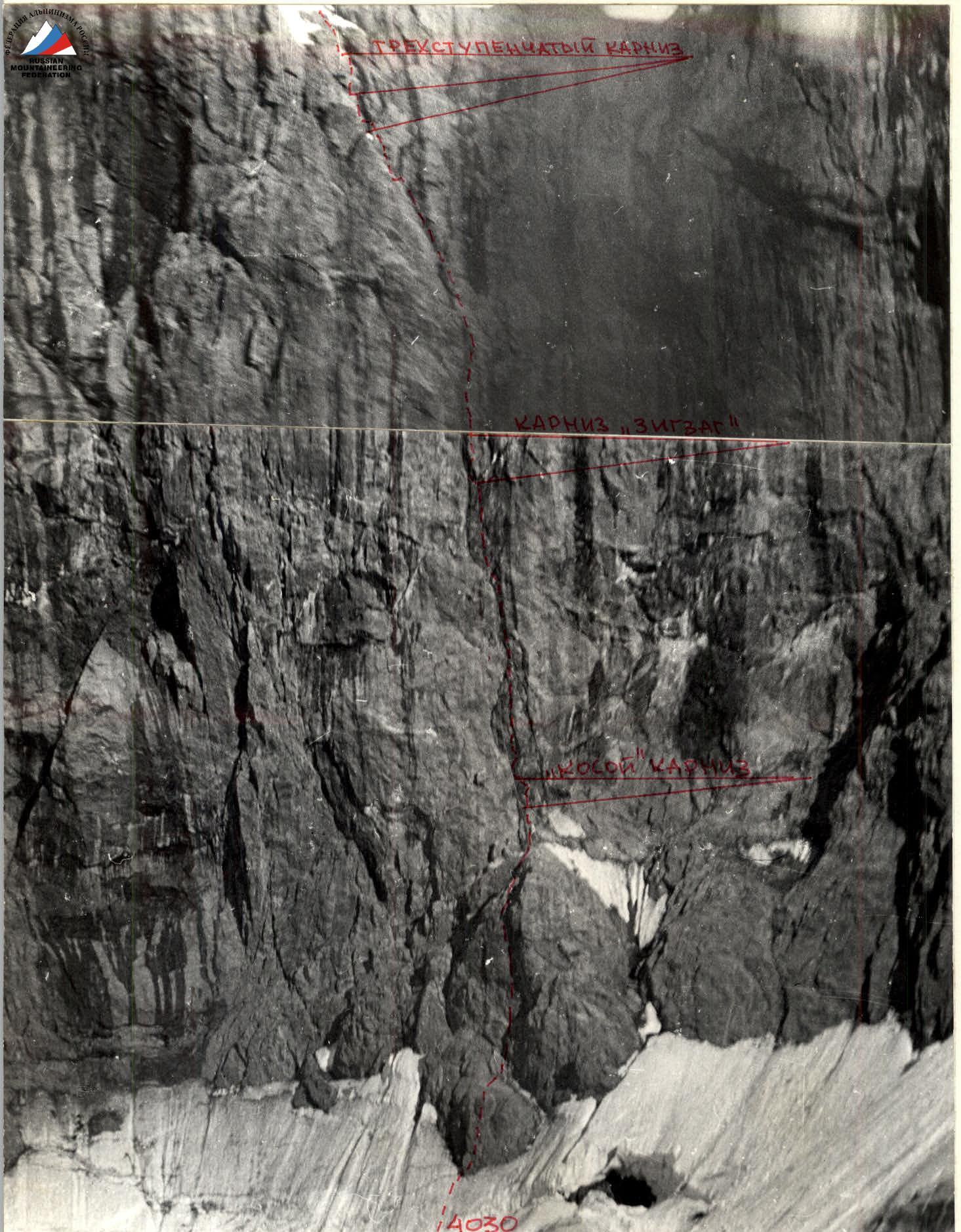
 N:X VIEW ON THE "TRIANGULAR SHEER" WALL
SECTIONS 2–27. Cornice belts are visible
Taken on 18.07 at 15:30
FROM THE AK-TEREK GLACIER /3700 m/
FROM A DISTANCE OF ~2 km F=50 mm
N:X VIEW ON THE "TRIANGULAR SHEER" WALL
SECTIONS 2–27. Cornice belts are visible
Taken on 18.07 at 15:30
FROM THE AK-TEREK GLACIER /3700 m/
FROM A DISTANCE OF ~2 km F=50 mm
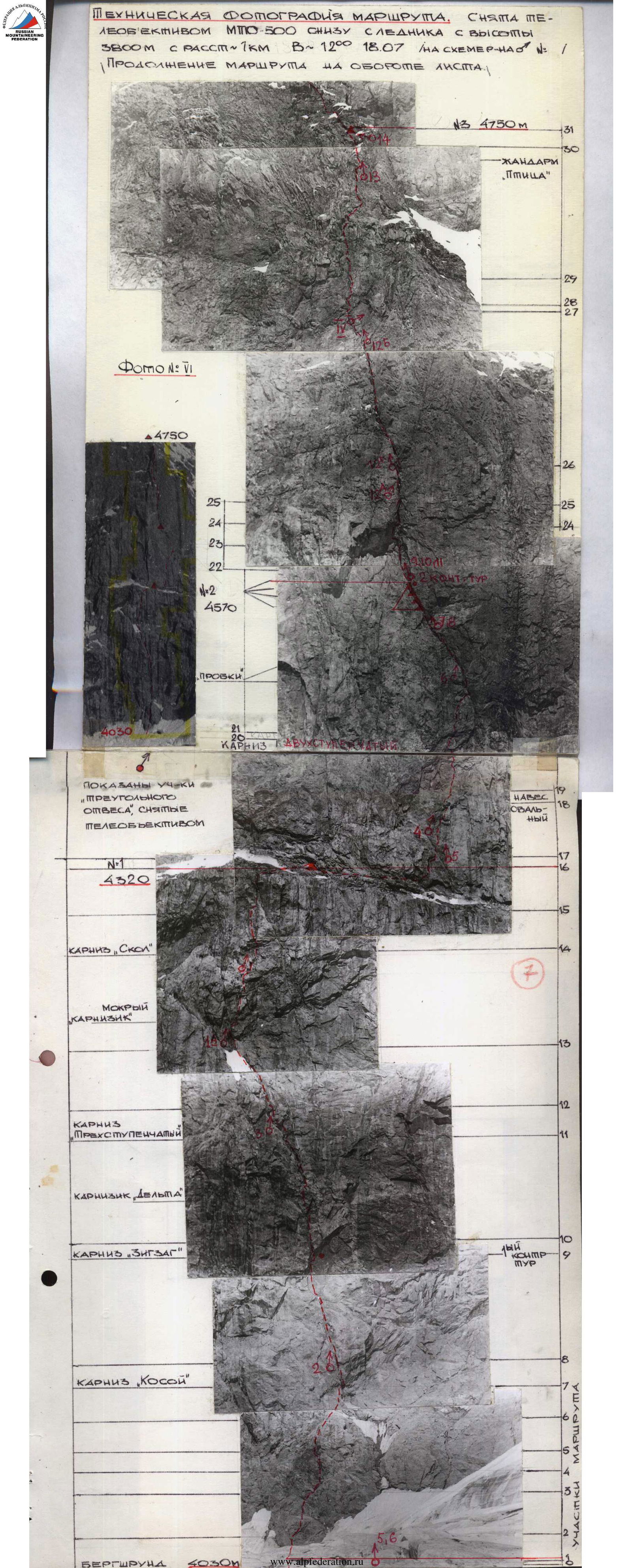 N:1 TECHNICAL PHOTOGRAPHY OF THE ROUTE, TAKEN WITH A TELEPHOTO LENS MTO-500 FROM BELOW FROM THE GLACIER FROM A HEIGHT OF 3800 M
FROM A DISTANCE OF ~7 km AT
N:1 TECHNICAL PHOTOGRAPHY OF THE ROUTE, TAKEN WITH A TELEPHOTO LENS MTO-500 FROM BELOW FROM THE GLACIER FROM A HEIGHT OF 3800 M
FROM A DISTANCE OF ~7 km AT 12:00 18.07 /ON DIAGRAM N° /
CONTINUATION OF THE ROUTE ON THE BACK OF THE SHEET.
PHOTO N:1.
SHOWS SECTIONS
OF THE "TRIANGULAR SHEER",
TAKEN WITH A TELEPHOTO LENS
3800 m
distance from the wall ~0.6 km
18.07 at 12:00 with a telephoto lens MTO-500
 №1 Sections 0–13 STRUCTURE OF THE LOWER PART OF
THE "TRIANGULAR SHEER". Water flows are visible on the wall from 11 o'clock.
Taken from the moraine of the Utren glacier on 19.07
at 13:00
№1 Sections 0–13 STRUCTURE OF THE LOWER PART OF
THE "TRIANGULAR SHEER". Water flows are visible on the wall from 11 o'clock.
Taken from the moraine of the Utren glacier on 19.07
at 13:00
 N:VII CONTINUATION OF THE ROUTE UPPER PART OF THE WALL AND PART OF THE RIDGE
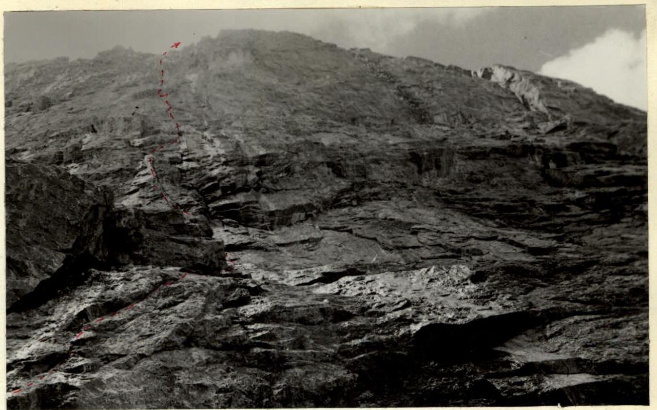 N:1A Sections 13–16. UP FROM
THE WET CORNICE. THE "FLAKE" CORNICE BELT IS VISIBLE Taken from section 13 on 17.07 at 18:00 F=50 mm
N:1A Sections 13–16. UP FROM
THE WET CORNICE. THE "FLAKE" CORNICE BELT IS VISIBLE Taken from section 13 on 17.07 at 18:00 F=50 mm
 №3. Sections 11–12 "ZHAK" under
the step of the three-step
cornice Taken from the 20th step on 17.07 at 15:00 F=50 mm
№3. Sections 11–12 "ZHAK" under
the step of the three-step
cornice Taken from the 20th step on 17.07 at 15:00 F=50 mm
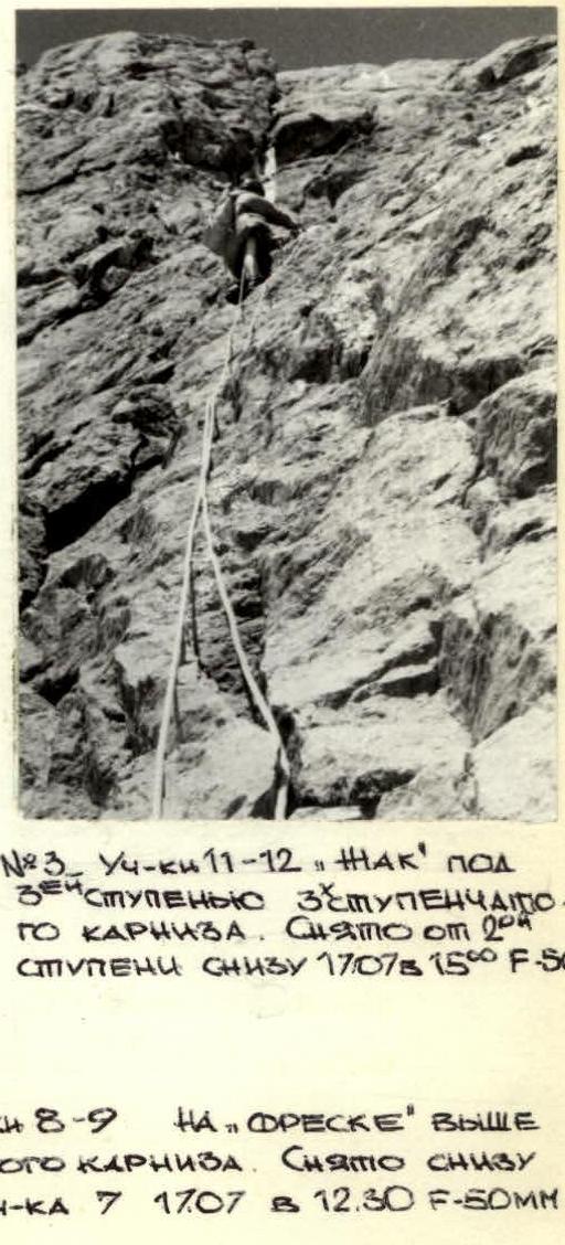 №2 Sections 8–9 ON THE "FRESCO" ABOVE
THE OBLIQUE CORNICE Taken from below
from section 7 on 17.07 at 12:30 F=50 mm
№2 Sections 8–9 ON THE "FRESCO" ABOVE
THE OBLIQUE CORNICE Taken from below
from section 7 on 17.07 at 12:30 F=50 mm
 N:4 Sections 17–19. Under
the "OVAL" CORNICE
Taken from below
from section 17 on 18.07
at 12:00 F=50 mm
N:4 Sections 17–19. Under
the "OVAL" CORNICE
Taken from below
from section 17 on 18.07
at 12:00 F=50 mm
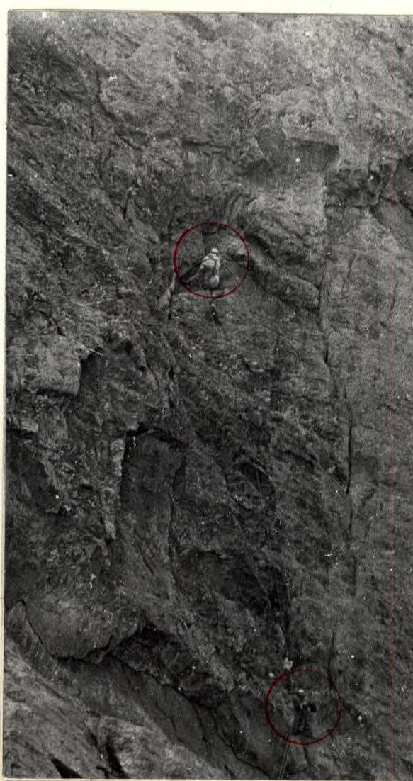 №5 Sections 16–19
UNDER THE "OVAL"
CORNICE. 4th
PARTICIPANT IS VISIBLE Taken from below
from the glacier H
№5 Sections 16–19
UNDER THE "OVAL"
CORNICE. 4th
PARTICIPANT IS VISIBLE Taken from below
from the glacier H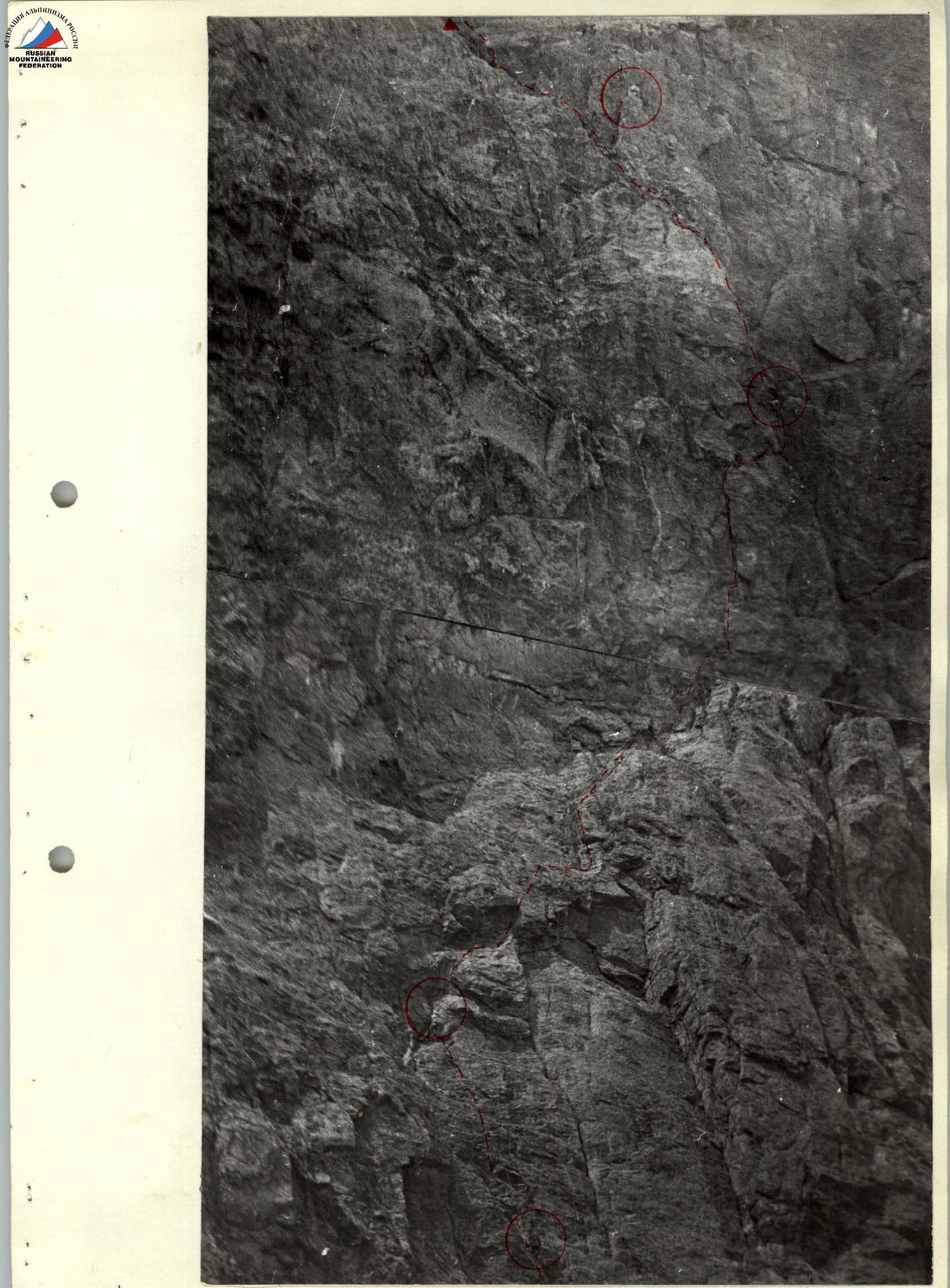 N:6 Sections 16–22 /4 PARTICIPANTS visible / Taken from the GLACIER SN-3800M
18.07 with a telephoto lens MPO-500 from a distance of 0.6 km at 15:00
/SEE LOGBOOK
N:6 Sections 16–22 /4 PARTICIPANTS visible / Taken from the GLACIER SN-3800M
18.07 with a telephoto lens MPO-500 from a distance of 0.6 km at 15:00
/SEE LOGBOOK
 №7 Section 22 GOLUBEV
ON A HANGING OVERNIGHT STAY
№2/4570 m/ IN THE "INTEGRAL" CHIMNEY Taken
18.07 at 20:30 F=50 mm
![img-31.jpeg]({"width":691,"height":1093,"format":"Jpeg","uri":"https://
№7 Section 22 GOLUBEV
ON A HANGING OVERNIGHT STAY
№2/4570 m/ IN THE "INTEGRAL" CHIMNEY Taken
18.07 at 20:30 F=50 mm
![img-31.jpeg]({"width":691,"height":1093,"format":"Jpeg","uri":"https://