
Ascent Passport
- Pamir-Alay, Zeravshan ridge, Rog valley — 5.3.3.
- Peak MSU, 5430 m, via E edge of N wall and NE ridge (via shoulder 4831)
- Category 4B, first ascent
- Route type — snow and ice
- Route height difference 1250 m (by GPS)
Route length 2350 m. Length of sections 5 — 10 m, 6 — 0 m. Average slope: main part of the route — 52°, entire route — 37°.
-
Pitons left on the route: total 2; including bolted 0. Used on the route: rock pitons 3, chocks 2, ice screws 68. Used pitons: bolted stationary 0, including ITO 0, bolted removable 0, including ITO 0.
-
Team's travel hours: 44 h, 5 days.
-
Team leader: Kodysh Vadim Emilievich — Master of Sports in tourism
Team members:
- Bertov Mikhail Nikolaevich — 1st sports category in tourism
- Vakulyuk Vasily Vladimirovich — 1st sports category in tourism
- Kartashova Elena Anatolyevna — 1st sports category in tourism
- Ovchinnikov Ilya Lvovich — 1st sports category in tourism, 2nd sports category in mountaineering
- Petlitsky Vladimir Nikolaevich — Candidate Master of Sports in tourism
- Coach: Kodysh Vadim Emilievich — Master of Sports in tourism
- Departure to the route: 6:30, August 13, 2007
Reached the summit: 13:50, August 15, 2007. Returned to Base Camp: 12:00, August 17, 2007.
- Organization — MSU Tourism Club

Fig. 1: View from the north. Photo taken from the middle part of the Samjon river valley, from a distance of about 18 km. The ascent path is shown in red, the descent path is shown in green where they differ.
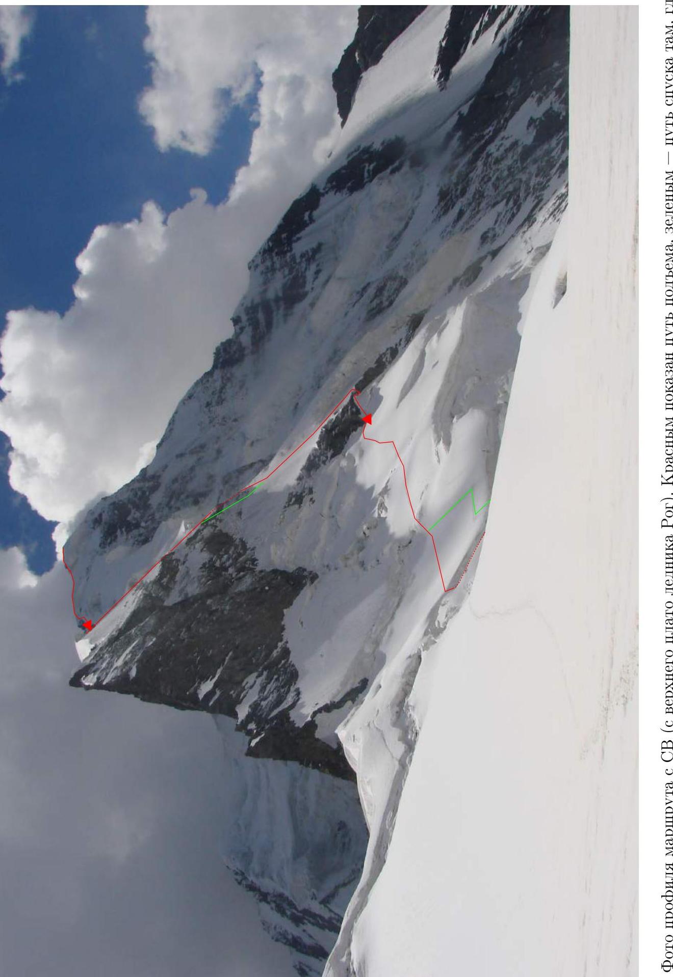
Fig. 2: Photo of the route profile from NE (from the upper plateau of Rog glacier). The ascent path is shown in red, the descent path is shown in green where they differ.
Description of the ascent by sections
| Section | Slope character | Length | Steepness | Difficulty | Pitons | Notes |
|---|---|---|---|---|---|---|
| 4150–4200 | Firn slope | 100 | 25–30° | 2 | - | |
| 4200–4230 | Snow section between crevasses | 50 | 10–20° | 1 | - | |
| 4230–4240 | Ice wall of bergschrund | 10 | 90° | 5 | 4 ice screws | |
| 4240–4340 | Traverse of firn slope above bergschrund | 500 | 25–30° | 2 | Insurance via ice axes | 50-meter rockfall-prone section in the middle |
| 4340–4350 | Traverse of firn slope | 50 | 40° | 3 | Ropes on ice axes | |
| Night | ||||||
| 4350–4380 | Ascent-traverse of firn slope under overhanging rocks | 50 | 50° | 3 | 1 ice screw, 1 chock, 1 rock | Processed in the evening |
| 4380–4370 | Descent to rock ledge | 10 | 50° | 3 | ||
| 4370–4400 | Ascent via rocks | 10 | 60° | 3 | 1 chock, 1 ice screw | |
| 4400–4600 | Ice slope | 300 | 45–55° | 4 | 18 ice screws | Danger of ice avalanches! |
| 4600–4630 | Ice slope in "gorge" | 50 | 45° | 4 | 3 ice screws | Danger of ice avalanches! |
| 4630–4780 | Ice slope | 250 | 45–55° | 4 | 15 ice screws | |
| 4780–4800 | Ice-firn slope — exit to ridge | 20 | 60° | 4 | 3 ice screws, ropes on ice axe | |
| 4800–4760 | Traverse of firn ridge to crevasse with flat area | 100 | 10° | 1 | - | |
| Night | ||||||
| 4760–5090 | Wide snow-ice ridge | 450 | 25–30° | 1–2 | 2 ice screws | |
| 5090–5120 | Ice slope | 50 | 40° | 3–4 | 4 ice screws | |
| 5120–5200 | Snow slope | 150 | 20–30° | 1 | - | |
| 5200–5220 | Ice slope | 30 | 45° | 4 | 2 ice screws, station on rock outcrop | |
| 5220–5330 | Wide snow ridge | 200 | 15–25° | 1 | - | |
| 5330–5430 | Narrow snow-covered rock-scree ridge | 200 | 30° | 2 | - |
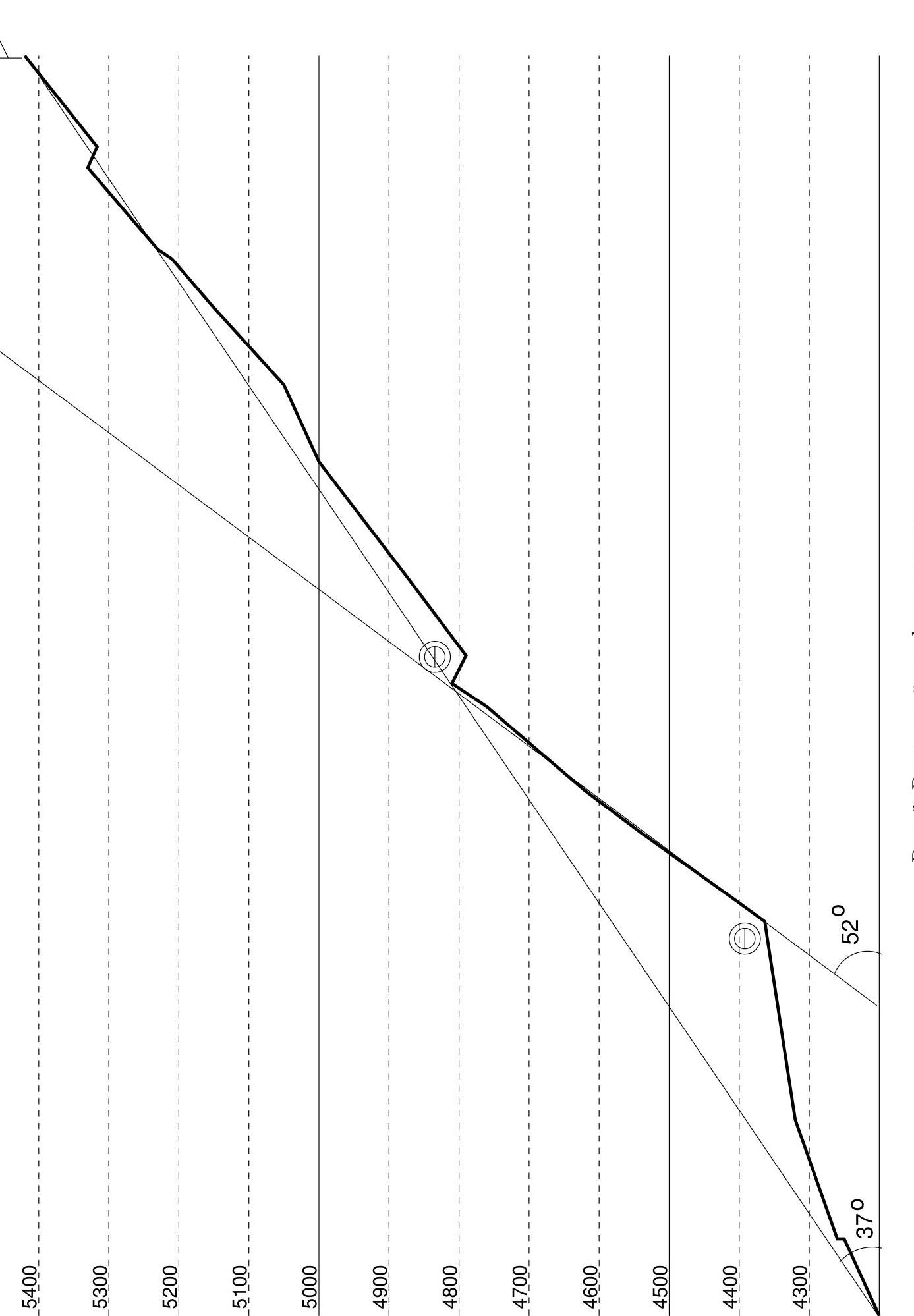
Fig. 3: Drawn profile of the route
General description of the area
The Zeravshan ridge is part of the Pamir-Alay mountain region. It separates the large valleys of the Zeravshan and Vakhsh rivers. To the east, it connects with:
- Alay ridge;
- Turkestan ridge.
To the west, it tapers off southwest of Samarkand.
In its middle part, it connects with the Gissar ridge. In the western part, through the Fann Mountains, it connects with the same Gissar ridge.
The ridge has been explored mainly in the areas of:
- Fann Mountains;
- Matcha knot.
There are very few climbed peaks in the central part.
You can reach the ridge:
- From the north — from the Zeravshan valley;
- From the south — from the Vakhsh valley.
There are roads accessible to motor vehicles along both valleys. Our team ascended the ridge from the north via the Rog river valley — a left tributary of the Zeravshan. There are several small kishlaks in the valley, and trails lead almost to the tongue of the Rog glacier.
The Tuteklik massif, whose highest point is Peak MSU, is located in the main ridge in the upper reaches of the West Rog glacier. A long northern spur extends from the main summit. To the west of it, through a deep saddle, a short southern spur branches off, ending in Peak Tutek (the second-highest peak of the massif). Unfortunately, during the mapping of the area in the 1960s, due to a cartographers' error, the previously existing main summit disappeared from the maps. Apparently, because of this, it remained unconquered until 2007.
In 1986, a team from the "Varzob" alpine camp made a first ascent of Peak Tutek via the southeast wall (category 6A route). In poor visibility, they were only able to determine that to the north there was an "unknown peak above 5000 m".
The existence of a higher peak in this area (presumably, 5430 m, i.e., the highest point of the Zeravshan ridge) became known from a group of tourists from Tashkent led by B. M. Krakhmalny, who visited the area in 1990 and gave the massif the name Tuteklik. Then it was seen by 2 groups of tourists from Moscow. The ascent was planned based on the information from these three groups.
The southern wall of the main summit is a rock wall, sheer. The rocks are loose, with many loose stones. Reconnaissance of the possibility of descending from it led to a negative result. Under the wall lies a giant icefall of the right branch of the Tuteklik glacier, flowing from the saddle between the Main and Southeast summits. The northwestern slope is ice-covered, wide, apparently safe and convenient for ascent. However, it descends to a separated left tributary of the West Rog glacier, ending in a very dangerous narrow and high rock gorge, where ice avalanches constantly occur. The Western ridge also leads to the same glacier. The Eastern ridge is a rock blade, largely sheer, and in places overhanging. In connection with this, the North wall was chosen for the ascent. Its eastern part is ice-covered, intersected by 2 rock belts. The belts provide an opportunity to shelter from avalanches from the middle and upper parts of the wall. The ascent leads to the snow-ice part of the Eastern ridge above the end of the rock blade. The approach to the North wall goes through the icefall of the West Rog glacier.
Approaches to the summit
August 10, 2007. Samjon kishlak — upper reaches of the Rog river
Clear. After a day of continuous eating, we set out at 12:00 towards the Rog kishlak. In addition to the bridge over the Zeravshan marked on the map in the Khudjif-Bolo kishlak, there is now a bridge in Samjon, although only small cars can cross it. According to local residents, the trail marked on the map on the orographic right bank of the Rog river actually ends soon. The main trail goes:
- initially along the left bank through the Rog kishlak;
- from the kishlak, slightly gaining height, we follow along the irrigation canal;
- then the trail descends to the river via a bridge, crosses to the right bank, and rises again.
We are surprised to find that there are 3 more kishlaks on the right bank in the valley, not marked on the map. The uppermost one — Sirog — is located 3 km below the glacier tongue. We spent the whole day fending off attempts to feed us, but were forced to stop for the night near this kishlak at 19:15 and accept dinner from the locals.
August 11, 2007. R0 — West Rog glacier
Clear in the morning, rain in the afternoon. Departure at 5:30. By 6:05, we reached the moraine ridges of the West Rog glacier. Then we proceed along the moraines closer to the left side. By 14:30, we reached the mouth of the left tributary glacier from the western slopes of the Tuteklik massif. It started raining. We set up camp on the glacier and sent a two-person team for reconnaissance.
It turned out that since 1991, according to the three groups that ascended the peak, the glaciers had retreated significantly:
- The tongue of the tributary is 200 m above the main glacier and hangs in sheer cliffs, where constant icefall occurs.
- Bypassing the tongue on the right is possible in principle but requires a 400–500 m ascent via rockfall-prone "ram's foreheads" with rope installation.
- Bypassing through the next tributary means passing another rock pass of unclear complexity.
We decided to ascend Tuteklik via the Eastern ridge (backup option). The eastern gentle branch of the West Rog glacier, recommended for ascent to the upper plateau by Krakhmalny and Bratsov, had also melted over 15 years, exposing steep, smooth "ram's foreheads". Therefore, we decided to ascend through the icefall of the Western branch, as Bratsov did.
August 12, 2007. Ascent via West Rog glacier
Clear. Departure at 6:10. We ascend under the icefall via a covered, then an open gentle glacier. At 7:10, we begin ascending in teams via the icefall, closer to its right side. Movement in teams, in places with rope installation on ice screws.
1st rope — 20 m, 40°. 2nd rope — 40 m, traverse of the slope with overcoming a crevasse. 3rd rope — 50 m, 40–45°. 4th rope — 20 m, up to 90°. 5th rope — 3 m descent into a crevasse 90° + 10 m traverse and ascent to its upper edge.
From the height of 3840 m, the glacier becomes gentler. We move in teams across the closed glacier. After another hour, we are in a cirque under the northeast slopes of Peak Tuteklik. The upper plateau of the glacier with the Rog and Rukh passes is 150 m above us, beyond an ice rise. We set up camp at 15:10. From here, we will ascend the summit of the Tuteklik massif via the North wall and Eastern ridge. Ascent directly up the icy part of the North wall is impossible since the wall is cut off by multi-meter ice ledges at the bottom. We decide to follow the route developed back in Moscow — ascend to the left of the direct path, where the ledges turn into a bergschrund, and traverse the slope under the rock bastion to the west to a place where a steep ice slope, intersected by 2 rock belts, ascends to the Eastern ridge. We organize and leave a cache here for the next section of the route.
Ascent
August 13, 2007
Clear in the morning, snow in the evening. Departure at 5:45. We ascend a firn slope with a slope of 25–30° in teams. We reach the lower crevasse. The crevasse is 10–15 m wide. The upper edge is sheer, with overhangs up to 3 m high, 15–25 m. We find a section without an overhang, with a slope of about 90°. By 7:15, we reach the upper edge of the crevasse with the help of rope pulls. The slope above the crevasse has a slope of 25–40°. Very hard firn. We traverse it to the west, installing 9 ropes of horizontal ropes with a slight gain in height. Points on ice axes and ice screws. In the middle of the traverse, there is a more gentle section where many freshly fallen stones from the upper rock bastion lie. Here we proceed in teams at maximum speed. At the end of the traverse, we enter a randkluft under overhanging rocks. 50 m ahead is the place to ascend through the rock belt and further up the ice. However, further ascent today is dangerous — ice avalanches regularly fall down the slope from the nearby seracs to the west. At 12:10, we stop for the night in the randkluft. 2 hours of work — and we have created platforms for 2 tents in the randkluft. The rocks overhanging our bivouac reliably protect us from avalanches. In the evening, we installed 50 m of horizontal ropes along the randkluft + 15 m down — to a convenient exit through the rock belt onto the ice slope. Intermediate points — 1 ice screw, 1 rock pit, 1 chock, station on 2 rock pitons.
August 14, 2007
Clear in the morning, snow showers in the afternoon, fog. Departure at 5:20. We passed the ropes installed in the evening. Then the first person descended 15 m along the rocks and ascended via rocks of medium difficulty (10 m slabs about 50°, intermediate point on a chock). For the ascent of the others, the ropes were redirected 5 m via sheer rocks. Further, 14 ropes via a 40–60° ice slope. Points on ice screws. The wall is north-facing, so even ice screws with a handle and polished go in with difficulty. We passed the second rock belt via an ice "gorge". The slope is dangerous due to ice avalanches! We tried to hide under the walls of seracs on the right. However, only one avalanche occurred above us, covering this ice "gorge" half an hour after we passed it. We exit onto the sharp snow-ice Eastern ridge above its rock base. The exit point is between seracs on the right and a giant cornicle on the left. We slightly descend along the southern slope to the upper edge of the rock South wall of the Tuteklik massif and proceed 100 m along the edge to the west. Here we cross the ridge back to the north and descend into a bergschrund under it. We set up camp here at 19:15. We cut and create a platform in the bergschrund.
August 15, 2007
Clear in the morning, fog and snow showers in the afternoon. Departure at 6:00. The ridge above the bivouac widens, becoming stepped with transverse ice crevasses to the Eastern sub-summit. Deep snow alternates with hard ice. To the sub-summit, there are 3 snow-ice ascents. Slope up to 50°. 100 m of ropes installed. Between the sub-summit and the summit — a destroyed narrow rock ridge. We proceed in teams with simultaneous insurance via outcrops (40 minutes). We reached the summit at 13:40. We built a cairn. Descent via the ascent route to the camp in the bergschrund. During the descent, we also installed 100 m of ropes. We reached the camp at 17:30.
August 16, 2007
Clear in the morning, snow in the evening and at night. Departure at 6:10. Along the ridge, via the ascent route, in teams with simultaneous insurance, we exit to the point of the day before yesterday's exit to the ridge. From here, we start installing ropes down. During the descent, we try not to lengthen the path, hiding under seracs, and descend as quickly as possible along the line of water fall.
- 250 m of ropes to the upper rock belt.
- We don't risk entering the "gorge" again.
- We descend directly down via rocks — 75 m of ropes.
The rocks are steep, destroyed, and very rockfall-prone. We descend, shifting slightly to the left. Under the rocks, there is hard, formed ice.
- 250 m of ropes via ice to the lower rock belt.
- Another 50 m of ropes from overhanging rocks, through a randkluft, and down a steep ice slope below it.
- Then 50 m of horizontal ropes along a snow-covered ice slope to the old bivouac in the randkluft.
We reached the bivouac at 14:30. Further movement today is rockfall- and avalanche-prone. We slightly restore the platforms and set up camp for the night.
August 17, 2007
Clear. Throughout the night, micro-avalanches from the rocks fell above us, consisting of snow that fell in the evening and at night. These avalanches covered the ice slope and greatly facilitated movement. Departure at 6:40. Having traversed 150 m down to the right via ropes, we proceeded in a traverse above the lower bergschrund in teams with simultaneous insurance. Having chosen a place almost without an overhang, we descended into the bergschrund (25 m, point on an "ice axe cross"). Along its lower edge, we exited onto the upper plateau of the West Rog glacier. We set up camp on the plateau under Pass Rukh at 12:40.
Recommendations
The North wall is dangerous due to rockfall from the rock belts and ice avalanches, especially in the second half of the day. In this regard, the location we used for bivouacs in the randkluft under the overhang of the lower rock belt is recommended. There are plenty of bivouac sites on the Eastern ridge.
The following routes are also of interest:
- Northwest slope;
- Western ridge.
However, to use them, it is necessary to find a safe path from the West Rog glacier to the flat part of its upper left tributary, bypassing the gorge.
Peak MSU
via E edge of N wall and NE ridge (via shoulder 4831)
Kodysh V. E. Zeravshan ridge — 5.3.3.