5.3.121
Championship of the Central Council of the Voluntary Sports Society "Burevestnik", 1982. High-altitude technical class
Report
On the ascent to Chapdara Peak (5297 m) via the Eastern wall, category 6B, undertaken by the team from the Voroshilovgrad Regional Council of the Voluntary Sports Society "Burevestnik".
| Team Leader | Zagirnyak M.V. |
|---|---|
| Team Coach | Lyapin Z.F. |

| 11.08 | Distance, m | Steepness, deg. | Terrain characteristics | Difficulty | Condition at the time of passage | Weather conditions | Rock | Nuts | Bolts | Ice |
|---|---|---|---|---|---|---|---|---|---|---|
| R19–R20 | 70 | 15 | Ridge | 5 | Monolith | Wind, snow | 4 | 1 | ||
| R20–R21 | 60 | 40 | Couloir. Leads to a ledge | 4 | Water in the couloir, loose rocks | 8 |
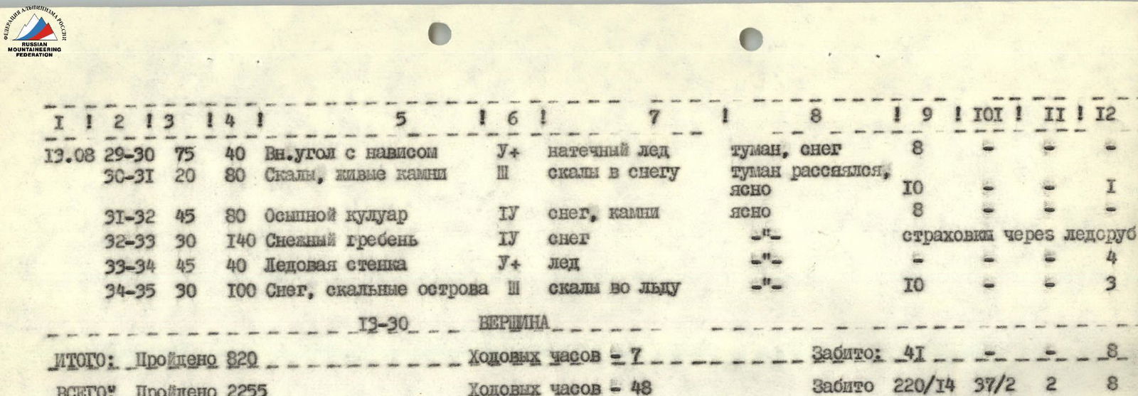
| 13.08 | Section | Distance, m | Steepness, deg. | Terrain characteristics | Difficulty | Condition at the time of passage | Weather conditions | Rock | Nuts | Bolts | Ice |
|---|---|---|---|---|---|---|---|---|---|---|---|
| R29–R30 | 75 | 40 | Internal angle with overhang | 5 | Serac ice | Fog, snow | 8 | ||||
| R30–R31 | 20 | 80 | Rocks, loose rocks | 3 | Rocks in snow | Fog cleared, clear | 10 | 1 | |||
| R31–R32 | 45 | 80 | Scree couloir | 2 | Snow, rocks | Clear | 8 | ||||
| R32–R33 | 30 | 140 | Snow ridge | 4 | Snow | Protection via ice axe | |||||
| R33–R34 | 45 | 40 | Ice wall | 5 | Ice | 4 | |||||
| R34–R35 | 30 | 100 | Snow, rocky outcrops | 3 | Rocks in ice | 10 | 3 |
TABLE OF MAIN CHARACTERISTICS OF THE ASCENT ROUTE
| Date | Section / Description | Distance, m | Steepness, deg. | Terrain characteristics | Difficulty | Condition at the time of passage | Weather conditions | Rock | Nuts | Bolts | Ice |
|---|---|---|---|---|---|---|---|---|---|---|---|
| 8.08 | Start of the route 15:00 | ||||||||||
| R0–R1 | 225 | 45 | Rocky outcrops like "ram's foreheads" | 5 | Dusty coating on rocks | Clear | 16 | 6 | |||
| R1–R2 | 220 | 45 | Snow slope with rocky outcrops | 2 | Firn | 12 | |||||
| R2–R3 | 120 | 60 | Slabs | 5 | Monolith | 18 | |||||
| Route processing 18:30 | |||||||||||
| R3–R4 | 55 | 60 | Internal angle, overhangs | 5 | Clean rocks | Clear | 4 | ||||
| R4–R5 | 40 | 80 | Crack with нависанием | Loose rocks | 6 | 3 | |||||
| R5–R6 | 40 | 80 | Crack turns into a wall | 6 | Monolith | 6/2 | 4 | ||||
| R1 checkpoint 20:30 | |||||||||||
| TOTAL: | Covered 680 m | Working hours: 5 h | Driven: 62/2, 13 | ||||||||
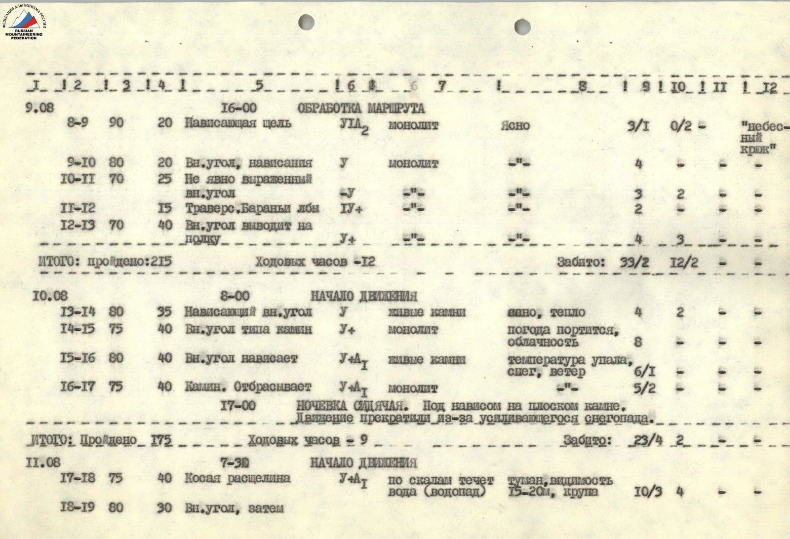
| 9.08 | Start of movement 8:00 | ||||||||||
| R5–R6 | 40 | 85 | Internal angle | 6 | Monolith | Clear | 6/1 | 5 | |||
| R6–R7 | 40 | 85 | Crack, overhangs | Monolith | 7 | 2 | |||||
| R7–R8 | 15 | 0 | Ledge | 3 | Red clay | 4 | |||||
| Arrival at the bivouac site 14:30 | |||||||||||
| Bivouac. Under an overhang on a ledge, sitting. 17:00 | |||||||||||
| R8–R9 | 20 | 90 | Overhanging crack | 6 | Monolith | Clear | 3/1 | 0/2 | "sky hook" | ||
| R9–R10 | 20 | 80 | Internal angle, overhangs | 5 | Monolith | 4 | |||||
| R10–R11 | 25 | 70 | Weakly expressed internal angle | ||||||||
| R11–R12 | 15 | Traverse. "Ram's foreheads" | 4 | 3 | 2 | ||||||
| R12–R13 | 40 | 70 | Internal angle leads to a ledge | 5 | 4 | 3 | |||||
| TOTAL: | Covered 215 m | Working hours: 12 h | Driven: 33/2, 12/2 | ||||||||
| 10.08 | Start of movement 8:00 | ||||||||||
| R13–R14 | 35 | 80 | Overhanging internal angle | 5 | Loose rocks | Clear, warm | 4 | 2 | |||
| R14–R15 | 40 | 75 | Internal angle like a chimney | 5 | Monolith | Weather deteriorating, overcast | 8 | ||||
| R15–R16 | 40 | 80 | Internal angle overhangs | 5 | Loose rocks | Temperature dropped, snow, wind | 6/1 | ||||
| R16–R17 | 40 | 75 | Chimney. Throws back | Monolith | 5/2 | ||||||
| Bivouac sitting. Under an overhang on a flat rock. Movement stopped due to increasing snowfall. 17:00 | |||||||||||
| TOTAL: | Covered 175 m | Working hours: 9 h | Driven: 23/4, 2 | ||||||||
| 11.08 | Start of movement 7:30 | ||||||||||
| R17–R18 | 40 | 75 | Diagonal crack | 5 | Water flowing over rocks (waterfall) | Fog, visibility 15–20 m, sleet | 10/3 | 4 | |||
| R18–R19 | 30 | 80 | Internal angle, then | ||||||||
| TOTAL: | Covered 820 m | Working hours: 7 h | Driven: 41, 8 | ||||||||
| TOTAL: | Covered 2255 m | Working hours: 48 h | Driven: 220/14, 37/2, 2, 8 |
The starting point of the route is marked by R1 checkpoint (a canister on the wall).
R0–R1 — rocks like "ram's foreheads".
R1–R2 — snowy couloir. Passage requires attention. Rocks are falling.
R2–R3 — slabs with many holds. Exit under a ledge under an overhang.
R3–R4 — along the internal angle to a narrow scree ledge.
R4–R5 — the crack is well-passed using швеллеров and nuts.
R5–R6 — there are loose rocks. Here, a transition to R1 checkpoint is possible (15 m to the right).
R6–R7 — diagonal crack, leads to a long (30 m) scree ledge. Bivouac site.
R7–R9 — difficult climbing. "Sky hook" applied. Exit to a "standing" rock. Belay point.
R9–R11 — along the internal angle, exit to a ledge.
R11–R12 — traverse to a ledge under an overhang.
R12–R13 — along the ledge 4 m to the right and then up along a weak internal angle.
R13–R14 — crossing the scree couloir from left to right and then along the internal angle, exit to a ledge. R1 checkpoint. Possible bivouac site.
R14–R15 — straight up along the internal angle to the top of the rock. Belay is provided through a bend.
R15–R16 — internal angle leads to a scree ledge. 25 m to the right — water.
R16–R17 — along the slab, then through a chimney, exit to the top of a flat rock. On it, a sitting bivouac is organized.
R17–R18 — from the bivouac down to the right to the waterfall and 2 m before it, up along the crack. The crack leads to a niche in the wall. 6 m to the left — a good belay point.
R18–R19 — to the right (back) 4 m and then up along the internal angle, leading to a slab. Along the slab, traverse to the edge of the slab. Holds are small.
R19–R20 — along the ridge up, exit to a couloir. Water is flowing.
R20–R21 — along the couloir (loose rocks) — to a scree terrace under overhangs. Bivouac site.
R21–R22 — passage under the "red" rocks (left part of the terrace).
R22–R25 — initially along an icy couloir (10 m) and exit to slabs. Along the slabs, exit to the edge of a slab.
R25–R26 — along the ridge, exit to a ledge under an overhang.
R26–R27 — to the left, bypassing the overhang, and then along the crack, exit to a ridge. Destroyed slabs. 40 m to the right — a niche — R3 checkpoint.
R27–R28 — along the ridge to rocky outcrops and then to the first pinnacle. At its foot — bivouac site.
R28–R29 — transition from snow to rocks (ranclyft).
R29–R30 — to a ledge under an overhang, then along the internal angle through a snowy couloir (15 m). Along inclined slabs, traverse to the right (10 m).
R30–R31 — along a snowy ridge with rocky outcrops to the base of the 2nd pinnacle.
R31–R32 — passage along a scree couloir, bypassing the pinnacle to the right.
R32–R33 — along the ridge with alternating belay via ice axe.
R33–R34 — ice wall. In crampons on front teeth.
R34–R35 — along the ridge, initially along the left part. On rocks, ice and snow.
TEAM LEADER: M. ZAGIRNYAK, Master of Sports of International Class TEAM COACH: Z. LYAPIN