Ascent Passport
-
Ascent class: traverse.
-
Ascent area: Southern spurs of the Altai ridge: Kok-Su valley.
-
Traverse of peaks: Sons 4950 m — Tereshkova 4870 m — Bykovsky 4840 m — Popovich 4800 m — Nikolaev 4900 m — Gagarin 4850 m.
-
Estimated difficulty category: 5A.
-
Route characteristics:
Height difference: 1330 m, length of sections with 5th difficulty category — 460 m, average steepness.
-
Pitons used for passage:
Rock pitons — 67, ice pitons — none.
-
Total hours of climbing — 34.5.
-
Number of bivouacs and their characteristics:
Three bivouacs:
- First without water;
- Others with snow — good conditions.
-
Leader:
ROMANOV Evgeny Vasilyevich — 2nd category. Participants:
- NEPLOKHOV Andrey Dmitrievich — 2nd category.
- MALINOVSKY Andrey Igorevich — 2nd category.
- PESHCHERIKOVA Natalia Fedorovna — 2nd category.
-
Team coaches: NOVGORODTSEVA G.P. — Master of Sports.
EKIMOV S.M. — Master of Sports.
-
Departure date from the camp: July 11, 1978.
Return to the camp: July 15, 1978.
Route Description
(Explanation for the table of main characteristics)
From the "Alay" tourist camp (Kozhoba glade) ascent along the left (orographic) bank of the Keshka-Su river. Exit to old moraines in the cirque of peak Sons. Along old moraines — exit under the E/V ridge of peak Sons. From the camp — 5–5.5 hours.
Along scree — ascent to the saddle between peak Sons and peak Solieva. Left up along simple destroyed rocks like "sheep's foreheads" and a steep snow slope (40 m) — exit to the E/V ridge of peak Sons (R0–R1). (Insurance through an ice axe).
Along sheep's foreheads and heavily destroyed rocks of the ridge — exit to the snow-scree plateau of peak Sons. Simultaneous and alternating movement (R1–R2). Descent to peak Tereshkova along the western ridge of peak Sons, bypassing a large stone on the left. Further along a chimney-corridor, breaking off into the Arta-Kanshi gorge. At the end of the chimney — left. The ridge is steeply sloping, very heavily destroyed, so insurance is difficult to organize. Climbing is complex with top insurance. Two sport descents of 40 m. For the night, descended 40 m below the ridge to the southern side:
- The site is inconvenient and small;
- No water. (R2–R3)
From the bivouac — exit back to the ridge. Along the ridge — descent to the saddle under peak Tereshkova. The last 40 m — rappel descent. On the saddle, bivouacs are possible (R3–R4).
From the saddle — ascent to peak Tereshkova:
- Along rocks like "sheep's foreheads";
- Further along ledges to the summit tower.
Exit to peak Tereshkova along monolithic rocks. Climbing is moderately difficult. Insurance is piton and through ledges (R4–R5). Descent to the saddle under peak Bykovsky along a heavily jagged ridge consisting of rock outcrops like "sheep's foreheads" with a loose surface. The gendarme is bypassed on the left. Climbing is difficult with top insurance. One sport descent (30 m). To the saddle — rappel descent (40 m) (R5–R6).
Exit to the heavily jagged Eastern ridge of peak Bykovsky. Along heavily destroyed rocks of tile type — exit under black rocks. Here, the second bivouac is organized:
- The site is good;
- Water is available. (R6–R7)
From the bivouac — ascent along the Eastern ridge of peak Bykovsky, bypassing the gendarme on the left. Rocks are very destroyed, tile type. Climbing is difficult. Transition to the right side of the Eastern ridge and then ascent to peak Bykovsky — transition to the Northern
 ridge of peak Bykovsky along steep destroyed ledges. Along the Northern ridge, along destroyed rocks of moderate difficulty (insurance through ledges) — ascent to peak Bykovsky. Descent along the ascent route (R7–R8). Further along a very destroyed and heavily jagged Northern ridge — descent to the saddle under peak Popovich. Difficult climbing. Rappel descent to the saddle (40 m) (R8–R9).
From the saddle — ascent to peak Popovich along the wall (30 m). Traverse left to a vertical chimney in the left part of the wall. Climbing is difficult, insurance is piton. Along the chimney (30 m) — exit to a ledge on the southern side of the summit tower of peak Popovich (R9–R10).
Along the ledge left up — exit to a crack leading to the summit. From the ledge of peak Popovich — 40 m. Climbing is difficult. From the summit — descent along the crack to the ledge (R10–R11). Bypassing the summit tower along rocks of moderate difficulty — exit to the NW ridge of peak Popovich. Descent to the "finger" — difficult climbing. From the "finger" — rappel descent (40 m). Here, the third bivouac is organized:
- The site is good;
- Water is available. (R11–R12)
From the bivouac — descent along the sharp NW ridge of peak Popovich, the gendarme is bypassed on the left, with exit to the main couloir leading to the saddle behind the gendarme. Further along the sharp jagged ridge. Gendarmes are bypassed from the northern side (formed ice). Climbing is very complex. Rappel descent to the saddle under peak Nikolaev (40 m) (R12–R13).
From the saddle — straight up along scree and heavily destroyed rocks (rockfall hazard) with piton insurance — exit to the summit of peak Nikolaev (R13–R14). Descent to the saddle under peak Tatarin along a steep heavily destroyed ridge. Exit to the saddle along the right wide rock couloir (rockfall hazard):
- First, right to a large stone (40 m);
- Then along ledges of the left part of the couloir — exit to the snow site of the saddle. Bivouac is possible, water is available. (R14–R15)
From the saddle — approach along snow to a small scree cone under the wall of peak Tatarin. Ascent along the wall:
- First, left along the internal angle (40 m);
- And then right up along the wall (60 m) — exit to the ridge leading to the summit. Climbing is difficult, insurance is piton. (R15–R16)
Along the ridge of moderate difficulty — approach to the right gap before the summit. Into the gap — sport descent (20 m) along rocks with formed ice and ascent to the summit along simple rocks (40 m) (R16–R17).
Descent from peak Tatarin along simple rocks of the ridge to the snow plateau (R17–R18). In its left part — descent along a scree couloir. In the middle of the couloir — snow and formed ice (40 m). Insurance through an ice axe and pitons. Descent to the gravel field of the Dzhu-gurtan river. Fourth bivouac (R18–R19).
From the bivouac — along the left (orographic) bank of the Dzhu-gurtan river to the confluence with the Kok-Su river and further along the left (orographic) bank of the Kok-Su river — descent to the "Alay" tourist camp (Kozhoba glade). 3–4 hours.
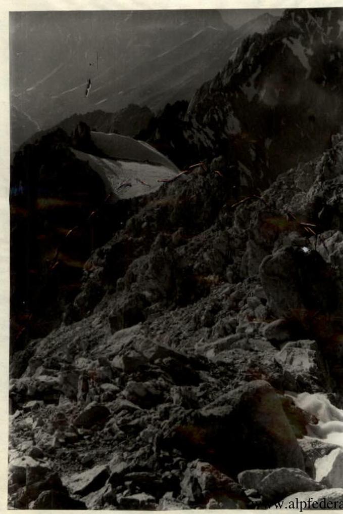
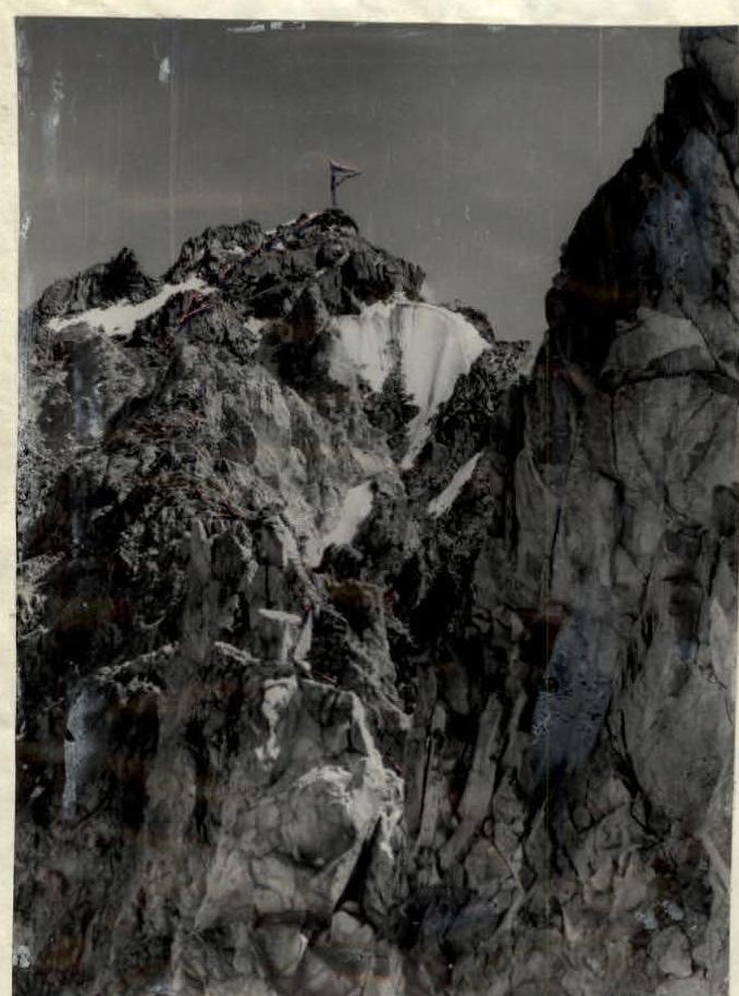
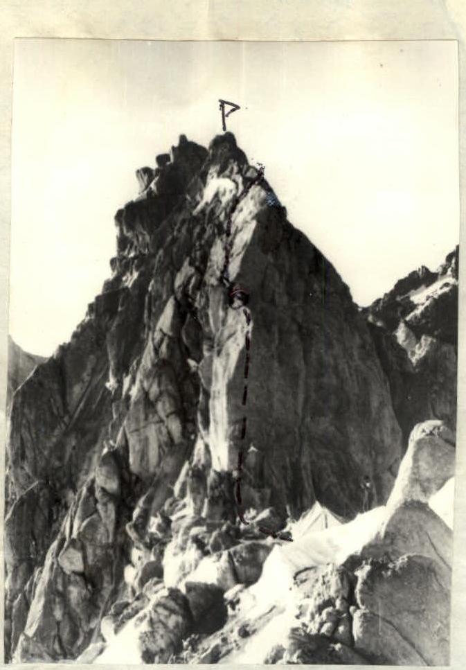
 Ridge from peak Sons to peak Tereshkova. 1st bivouac on the ridge of peak Sons.

Table of Main Route Characteristics
| Date | Designation | Average Steepness | Length in m | Terrain Character | Difficulty | State | Weather Conditions | Rock Pitons | Ice Pitons | Bolts | Time of Departure and Stop for Bivouac, Climbing Hours, Bivouac Conditions. |
|---|---|---|---|---|---|---|---|---|---|---|---|
| 11.07 | APPROACH TO THE ROUTE | ||||||||||
| R0–R1 | 30 | 200 | Scree | 1 | Clear | 5 hours. Time of exit on the route 5 hours | |||||
| 20 | 200 | Rocks | 1 | Like "sheep's foreheads" | Clear | 2 hours 30 minutes. Time of stop 21 hours. Bivouac without water, site is small. | |||||
| 50 | 40 | Snow | 1 | Clear | |||||||
| R1–R2 | 40 | 240 | Rocks | 1 | Heavily destroyed | Clear | 3 | 45 minutes. | |||
| R2–R3 | 50 | 200 | Rocks | 4 | Heavily destroyed | Cloudy | 8 | 24 hours 30 minutes. | |||
| 12.07 | R3–R4 | 30 | 240 | Rocks | 4 | Heavily destroyed | Clear | 3 | 24 hours 30 minutes. Time of exit 9 hours 30 minutes. | ||
| R4–R5 | 50 | 200 | Rocks | 3 | Monolithic | Clear | 2 | 60 minutes. Time of stop 20 hours 30 minutes. | |||
| R5–R6 | 40 | 350 | Rocks | 3 | Monolithic with few cracks | 3 | 2 hours. | ||||
| R6–R7 | 30 | 200 | Rocks | 3 | Destroyed, tile type | Cloudy | 2 | 2 hours. Good site, water available. | |||
| 13.07 | R7–R8 | 20 | 160 | Rocks | 3 | Heavily destroyed, tile type | Clear | 3 | 1 hour 30 minutes. Time of exit 8 hours 30 minutes. | ||
| 60 | 300 | Rocks, snow (ascent and descent from peak Bykovsky) | 2 | Destroyed | Clear | 2 | 1 hour 30 minutes. Time of stop 10 hours 30 minutes. | ||||
| R8–R9 | 60 | 430 | Rocks | 4 | Destroyed | Clear | 5 | 1 hour 30 minutes. | |||
| R9–R10 | 80 | 80 | Rocks | 4 | Monolithic | Clear | 6 | 24 hours 30 minutes. | |||
| R10–R11 | 70 | 120 | Rocks (ascent and descent from peak Popovich) | 4 | Monolithic | Clear | 4 | 24 hours 30 minutes. | |||
| R11–R12 | 65 | 120 | Rocks | 2 | Monolithic | Clear | 1 | 2 hours. | |||
| 14.07 | R12–R13 | 40 | 120 | Rocks | 2 | Destroyed | Clear | 2 | 50 minutes. Time of exit 8 hours. | ||
| 30 | 180 | Rocks, ice | 4 | Monolithic | 5 | 1 hour 10 minutes. | |||||
| R13–R14 | 50 | 120 | Rocks | 3 | Destroyed | 24 hours 30 minutes. | |||||
| 45 | 180 | Rocks | 3 | Monolithic | 2 hours. | ||||||
| R14–R15 | 70 | 240 | Rocks, ice | 4 | Heavily destroyed | 2 hours. Bivouac on the Dzhu-gurtan river, in the area of the Levinskaya glacier. | |||||
| R15–R16 | 80 | 100 | Rocks | 4 | Monolithic | 60 minutes. | |||||
| R16–R17 | 30 | 120 | 1 | Destroyed | 40 minutes. | ||||||
| R17–R18 | 30 | 160 | Rocks, snow | 1 | Destroyed | ||||||
| R18–R19 | 40 | 500 | Scree, snow | 1 | 1 hour. | ||||||
| Rocks |
TOTAL: Used for insurance — rock pitons — 67, rappel rings — 8, artificial points of support — not used.
Total climbing hours without approaches — 34.5.
Total route length — 4600 m.
Length of sections: 5th difficulty category — 460 m, 4th difficulty category — 1030 m, 3rd difficulty category — 2250 m, 1st difficulty category — 860 m.
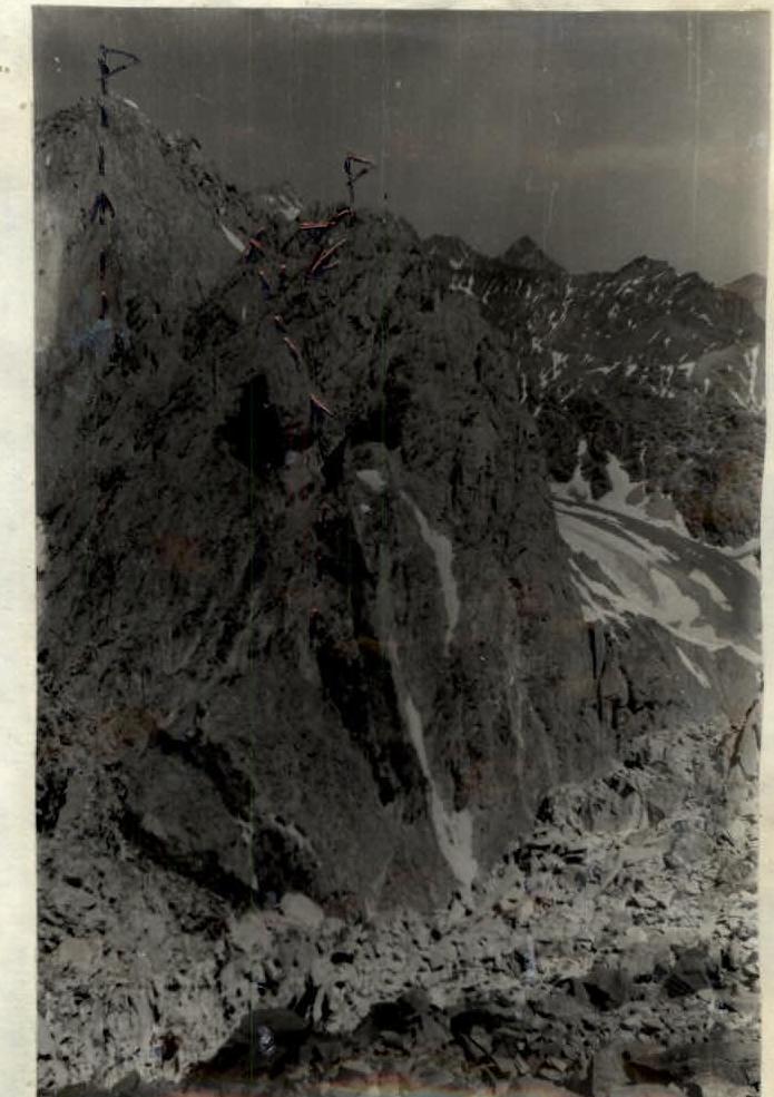
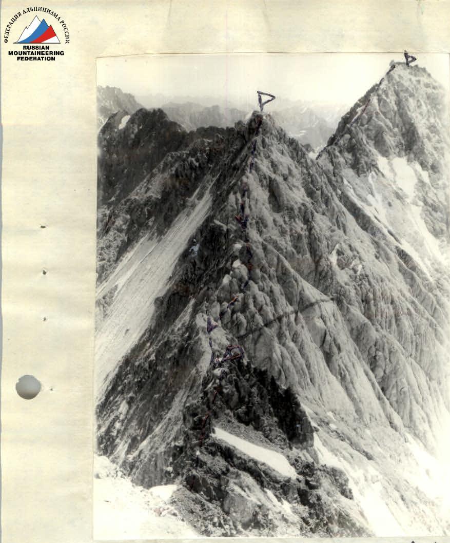 Section of the ridge from peak Sons to peak Tereshkova — 2nd bivouac under peak Bykovsky
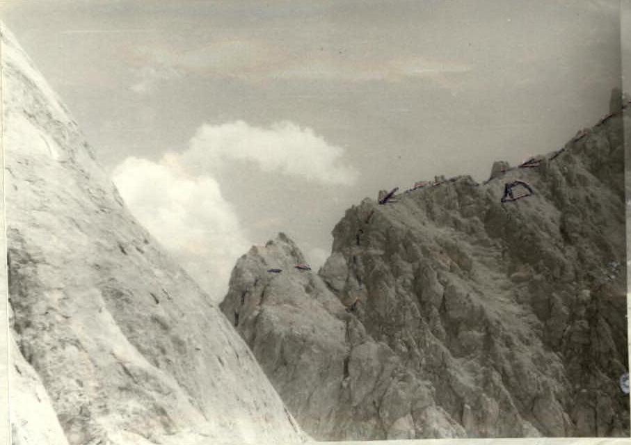
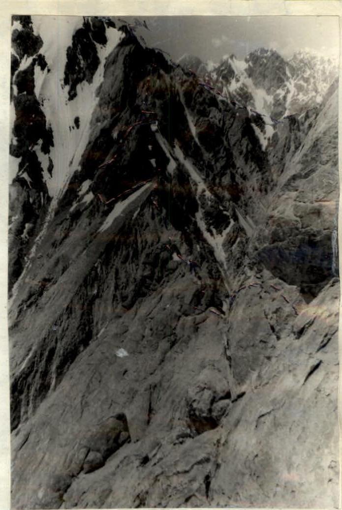
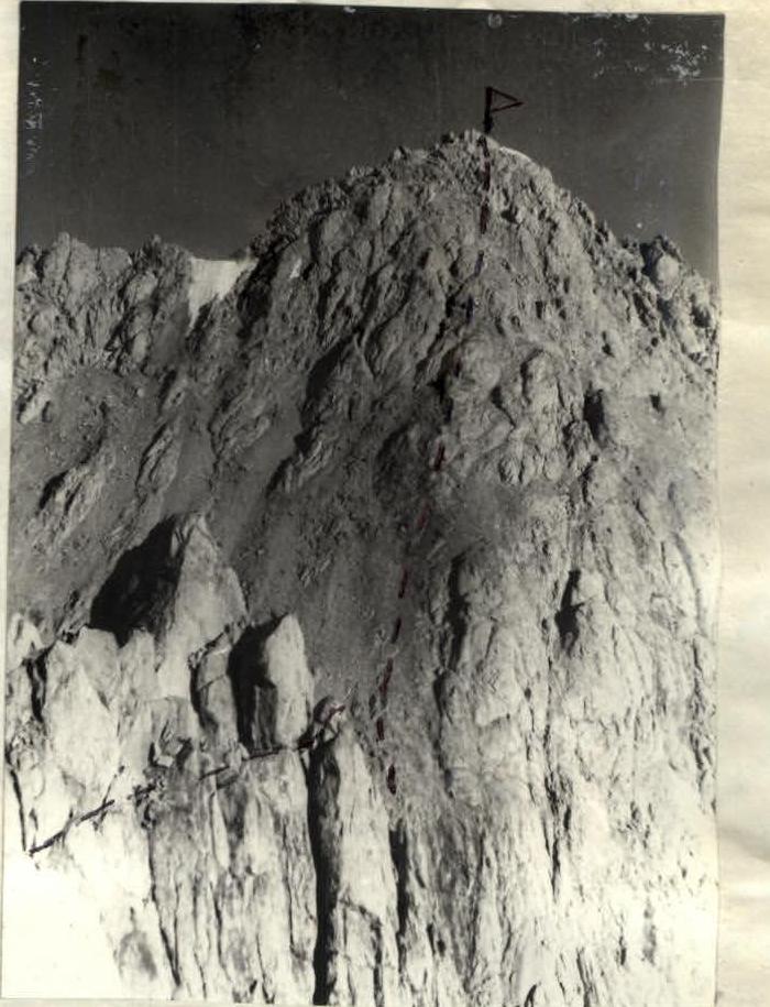
 Ridge from peak Tereshkova to peak Bykovsky and ridge to peak Popovich — View from peak Tereshkova.
 Peak Bykovsky and ridge to peak Popovich — View from peak Popovich.
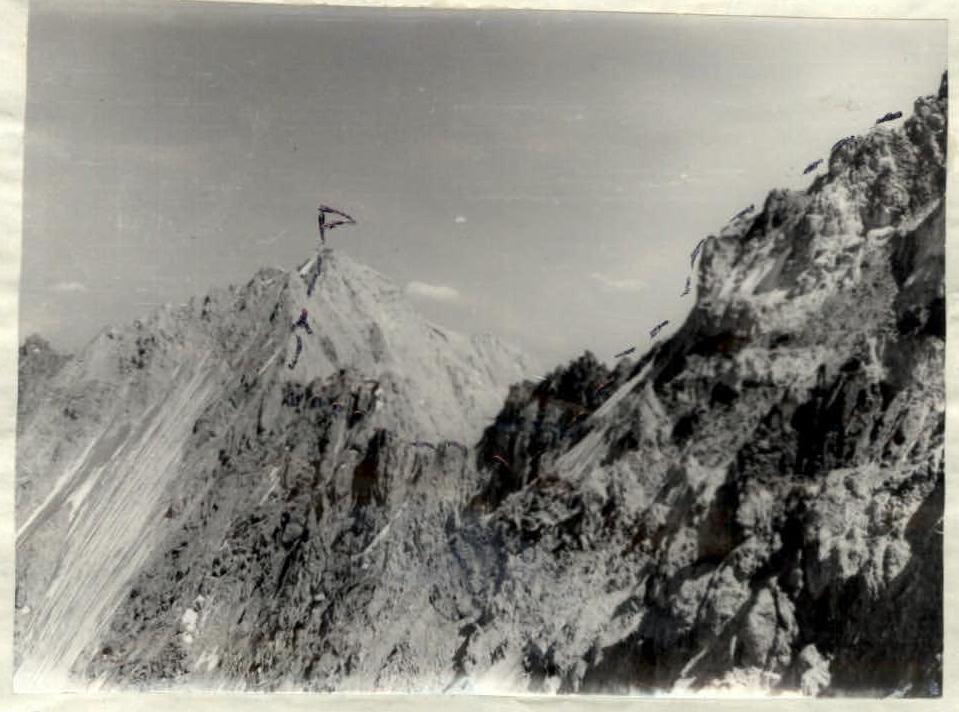
 Peak Popovich and peak Nikolaev — View from peak Bykovsky.
 Wall of peak Popovich.
 Rappel descent from peak Popovich — 3rd bivouac under peak Popovich.
 Ascent to peak Nikolaev.
 Ridge from peak Popovich to peak Nikolaev.
 Wall of peak Gagarin.