I. Climbing category - rock 2. Climbing area - Kemisdikty gorge, southern spurs of the Alay ridge. 3. Peak, its height, climbing route - Northern peak of Pik Skalny, via the "mirror" of the Eastern wall, 4421 m. 4. Proposed difficulty category - 5B 5. Route characteristics:
height difference of the route - 870 m, height difference of the wall section - 750 m, "mirror" 500 m, average steepness of the wall section - 87°, length of sections with 5-6 category difficulty - 690 m
- Pitons driven: for belaying / for ITO
rock 98 / 13, bolted 0 / 4, "heavenly" 0 / 6, chocks 14 / 17
- Number of climbing hours - 29 hours
- Number of nights and their characteristics:
2 nights, one sitting apart, one sitting together.
- Surname, name, and patronymic of the leader, participants, and their qualification: NIKOLAYCHUK Oleg Leonidovich - CMS - leader ONYSKO OREST Stepanovich - CMS FAST Alexander Alexandrovich - CMS GUSAKOVSKY Viktor Vladimirovich - 1st sports category KANINSKY Valery Apollonovich - 1st sports category
- Team coaches: BOLIZHEVSKY Valery Konstantinovich, SENCHINA Svyatoslav Vladimirovich
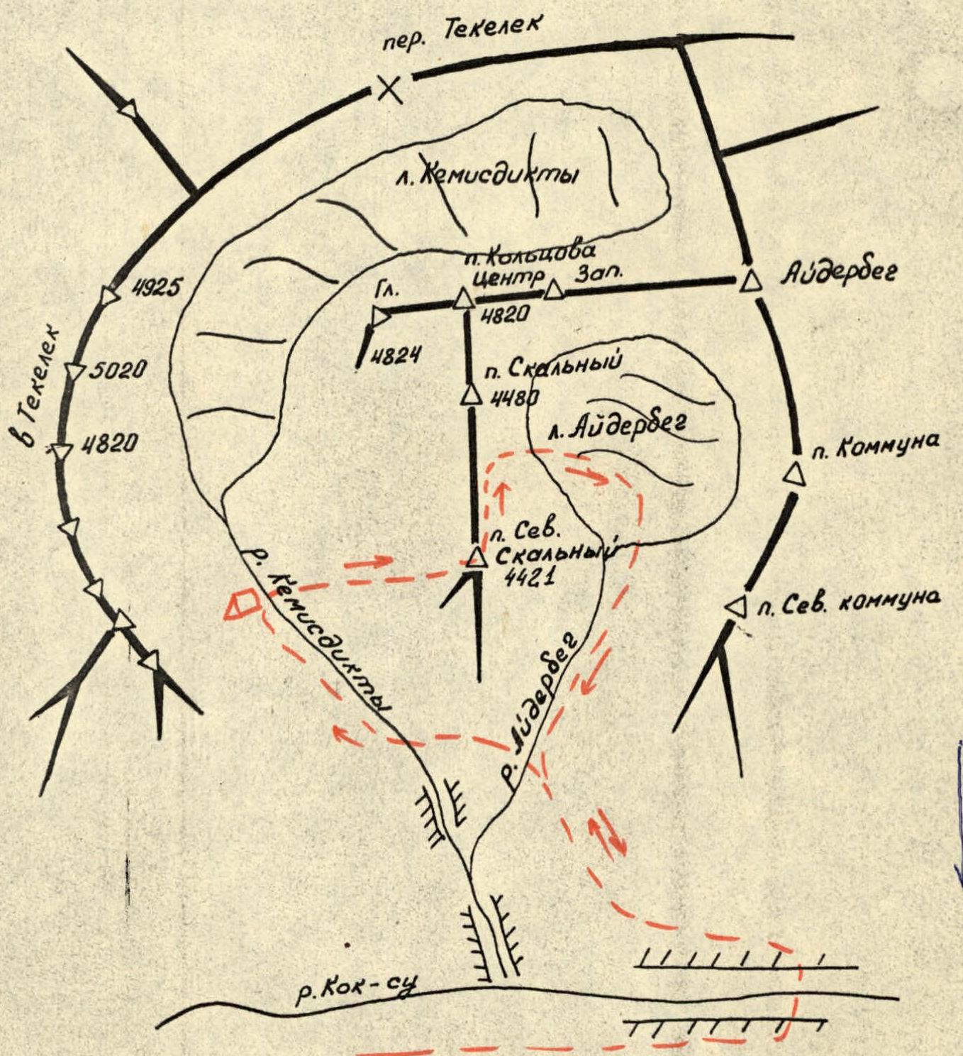
Map of the climbing area
II. Date of departure and return: 22-24 August 1981
Approach description
Along the Kok-Su river valley from the confluence of the Kemisdikty river, 0.5 hours upstream to a stone bridge over the Kok-Su river, then back along the same path. The Kemisdikty river can be crossed via a stone bridge in the lower reaches or via snow bridges further upstream. Then, to the left, along the moraine under the slopes of the Tekelek peaks to the Eastern wall of the Northern peak of Pik Skalny.
From the stone bridge over the Kemistdikty river to the bivouac on the moraine under Pik Skalny - 0.5-1 hour.
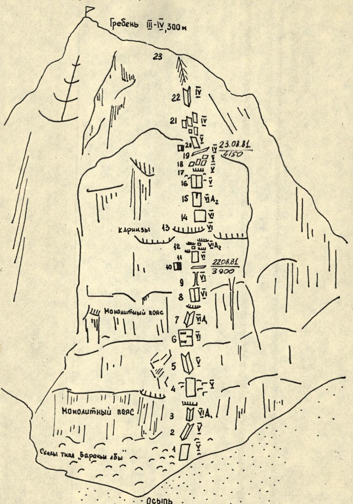
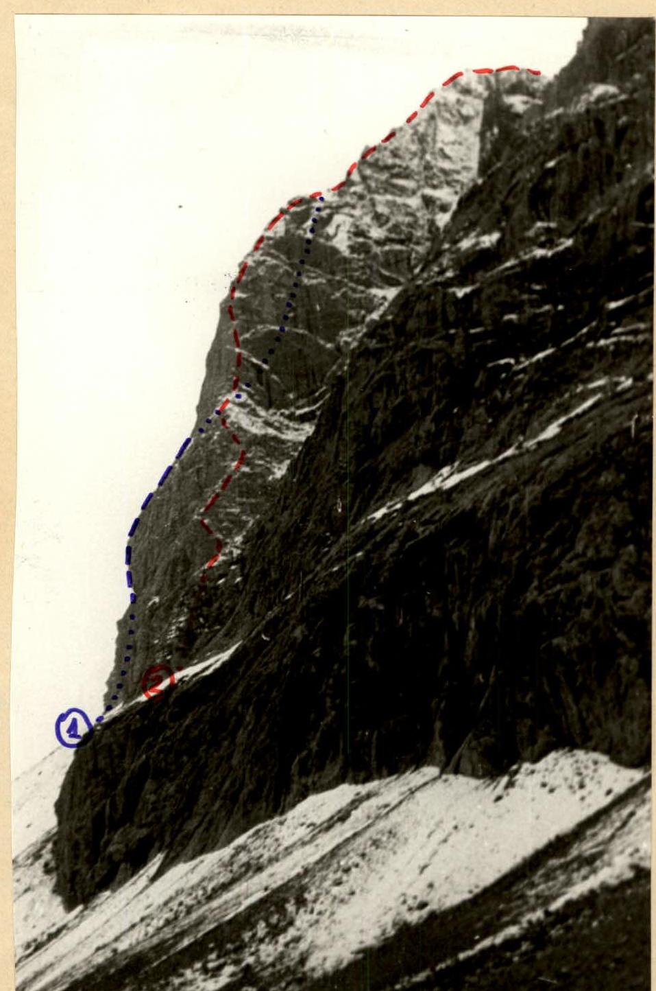
Photo 1. Route profile
- PriKVO team route.
- MVO team route.
Route sketch
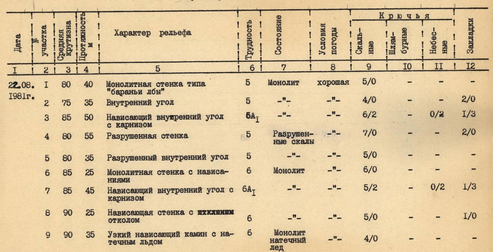
TABLE OF MAIN CHARACTERISTICS OF THE FIRST ASCENT ROUTE ON THE EASTERN WALL OF THE NORTHERN PEAK OF PIK SKALNY 5B CATEGORY (APPROXIMATELY)
| Date | Section | Average steepness | Length, m | Terrain characteristics | Difficulty | Condition | Weather conditions | Rock pitons | Bolted pitons | "Heavenly" pitons | Chocks |
|---|---|---|---|---|---|---|---|---|---|---|---|
| 22.08.1981 г. | R1 | 80° | 40 | Monolithic wall like "ram's foreheads" | 5 | Monolith | good | 5 / 0 | - | - | - |
| R2 | 75° | 35 | Inner corner | 5 | - | - | 4 / 0 | - | - | 2 / 0 | |
| R3 | 85° | 50 | Overhanging inner corner with a cornice | 5B | - | - | 6 / 2 | - | 0 / 2 | 1 / 3 | |
| R4 | 80° | 55 | Destroyed wall | 5 | Destroyed rocks | - | 7 / 0 | - | - | 2 / 0 | |
| R5 | 80° | 35 | Destroyed inner corner | 5 | - | - | 5 / 0 | - | - | - | |
| R6 | 85° | 25 | Monolithic wall with overhangs | 6 | Monolith | - | 6 / 0 | - | - | - | |
| R7 | 85° | 45 | Overhanging inner corner with a cornice | 6А | - | - | 5 / 2 | - | 0 / 2 | 1 / 3 | |
| R8 | 90° | 25 | Overhanging wall with an overhanging chip | 6 | - | - | 5 / 0 | - | - | 1 / 0 | |
| R9 | 90° | 35 | Narrow overhanging chimney with flowstone | 6 | Monolith, flowstone | - | 4 / 0 | - | - | - | |
| Total for the day: | 350 м | Climbing hours — 10 | |||||||||
| 23.08.1981 г. | R10 | 45° | 5 | Narrow inclined ledge | 4 | Scree, flowstone | good | 6 | - | - | - |
| R11 | 90° | 55 | Monolithic wall with an overhang | 6 | Monolith, wet | good | 6 / 0 | - | - | 1 / 0 | |
| R12 | 90° | 35 | Cornices, slabs | 6А2 | Monolith | - | 4 / 3 | - | 0 / 2 | 1 / 3 | |
| R13 | 100° | 25 | Large cornice | 6 | - | - | 4 / 4 | - | - | 2 / 4 | |
| R14 | 85° | 20 | Slab | 6 | - | - | 4 / 0 | - | - | - | |
| R15 | 95° | 25 | Overhanging monolithic wall with a slit at the top | 6А2 | - | - | 3 / 2 | 0 / 4 | - | 2 / 4 | |
| R16 | 75° | 5 | Wall like "ram's foreheads" with a slit | 5 | - | - | 5 / 0 | - | - | - | |
| R17 | 110° | 5 | Cornice | 5 | - | - | 1 / 0 | - | - | 1 / 0 | |
| R18 | 70° | 60 | Slabs | 5 | - | - | 6 / 0 | - | - | - | |
| R19 | 45° | 5 | Inclined ledge | 4 | Scree, snow | - | 6 | - | - | - | |
| Total for the day: | 280 м | Climbing hours — 13 | |||||||||
| 24.08.1981 г. | R20 | 70° | 60 | Ramp | 5 | Destroyed rocks | Fog, snowfall | 8 / 0 | - | - | - |
| R21 | 65° | 120 | Slabs | 4 | Monolith | - | 6 / 0 | - | - | - | |
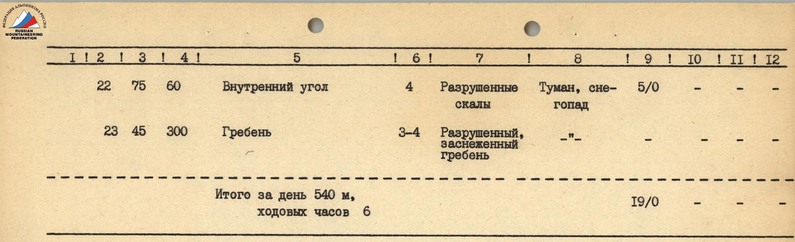
| R22 | 75° | 60 | Inner corner | 4 | Destroyed rocks | Fog, snowfall | 5 / 0 | - | - | - | |
| R23 | 45° | 300 | Ridge | 3–4 | Destroyed, snow-covered ridge | - | - | - | - | - | |
| Total for the day: | 540 м | Climbing hours — 6 | |||||||||
| Total length | 1170 м | Climbing hours — 29 | 98 / 13 | 0 / 4 | 0 / 6 | 14 / 17 |

Brief explanation of the main characteristics table
22 August 1981
It snowed all night. In the morning, everything looked like winter. At 8:00, the sun lit up the Eastern wall, and we had hope. At 11:30, the first rope team, taking the main equipment, went out to process the route. Soon, the other participants, packing up the bivouac, followed under the wall.
The route starts with scree, 100 m to the right and above the lowest point of the wall.
Immediately, complex fifth-category climbing begins. At first, rocks like "ram's foreheads" lead to the base of an inner corner, along which we move up and slightly to the right - towards the base of the second inner corner, closed at the top by a cornice. Here, we use the full arsenal of mountaineering equipment: from ordinary pitons and chocks to the latest innovation - "heavenly" pitons.
After passing the cornice, we reach a belt of destroyed rocks and first along the wall, then along the inner corner, we reach the next monolithic belt. Here, the steepness increases - we approach the middle part of the "mirror". We move along walls with cornices in the direction of a giant inner corner, at the top of which a ledge is visible, chosen for the night's bivouac.
Throughout the entire section up to the ledge, climbing is extremely difficult, and in some places, ITO is necessary, which we hang on "heavenly" pitons. This significantly shortens the time of passage.
It was already dark when everyone gathered on the ledge, where we settled in for a sitting bivouac, spreading out along the entire length of the most comfortable spots.
23 August 1981
Yesterday, while all participants were reaching the bivouac site, Fast A. and Kaninsky V. processed another rope above.
From the ledge, the wall starts to overhang, and after two ropes, free descent becomes impossible. The path is only upwards. Here is the key point of the route.
- A series of small cornices leads under a huge cornice, which is passed from right to left.
- Then, along slabs, we approach a smooth wall, at the top of which a crack is visible.
- 4 bolted pitons, a series of wedges and chocks - and the "mirror" is passed.
V. Kaninsky spent about three hours on this rope. When climbing up the freely hanging rope, we were thrown away from the wall in the lower part by 6-8 m.
The path further is easier. After passing a wall like "ram's foreheads", a cornice, and slabs, we gather again for a night's bivouac in complete darkness.
24 August 1981
In the morning, the weather worsened: fog, snowfall. We quickly gathered and moved up in the direction of the ridge leading to the Northern peak of Pik Skalny.
The difficulties ended - along the snow-covered rocks of the ridge, we reached the summit. We descended towards the Main peak of Pik Skalny to a saddle, and then along the 3B category route - to the Aydyrbek gorge.
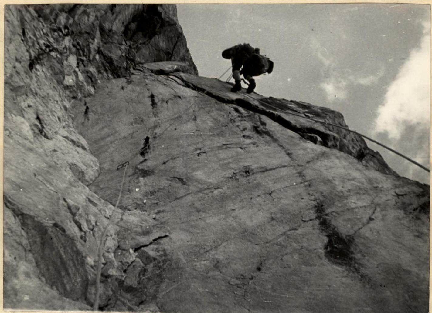
Photo 2. Section R1-R2.
Photo 6. Section R10-R11.

Photo 4. Section R12-R13, overcoming a large cornice.
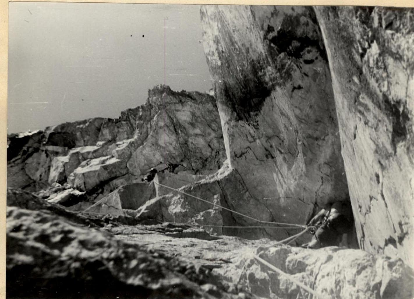
Photo 8. Section R14-R15, ascending via fixed ropes.