ASCENT DOCUMENT
- Climbing category — technical.
- Climbing area, ridge — Alaysky.
- Peak, its height, ascent route — Aydarbek, 5127 m, along the western ridge via peak 4890 m.
- Proposed difficulty category — 4A cat. diff.
- Route characteristics: height difference — 1100 m. length of R5–R6 sections — average steepness — 35°
- Pitons driven: for belay, for creating artificial holds.
| rock | –4 |
|---|---|
| ice | –5 |
| bolt | – |
- Number of climbing hours — 20.
- Number of bivouacs and their characteristics — 1 bivouac.
- Surname, name, patronymic of the leader, participants, and their qualification:
- Dobrynin Vitaly Stepanovich — leader, 1st sports category
- Liplyavy Igor Vasilyevich — 1st sports category
- Chetkin Alexander Nikolayevich — 1st sports category
- Tarasova Tatyana Ivanovna — 1st sports category
- Team coach — Zaev E.F.
- Date of departure and return: Departure — August 5, 1977. Return — August 6, 1977.
The Aydarbek peak, 5127 m high, is located in the southern spur of the Alaysky ridge and closes the cirque with the glacier of the same name (see the map-diagram of the Alaysky ridge) and peaks 4484 (p. "Skalniy")*, 4824 (p. I.S. Nikitina), 4890 (Nameless), 5027 (p. Kommuna). In addition to the present ascent route, the following routes were laid on the Aydarbek peak in the 1977 season:
- 5B cat. diff. (along the northern wall, first ascent);
- 5A cat. diff. (along the northern counterfort).
Prior to this period, no ascents to the Aydarbek peak were recorded, and the routes to the peak were not classified. * — the names of the peaks given by the first ascenders — Voronezh climbers — are in brackets.
Ascent Description
The ascent was made from a bivouac located on the right (orographic) lateral moraine of the Aydarbek glacier, 1.5–2.0 hours' walk from the start of the route and 3.5–4.0 hours from the "Alay" base camp, located at the confluence of the Kok-Su and Kemisdykty rivers.
From the bivouac, cross the Aydarbek glacier in the direction of the southern slopes of peak 5020 m (p. Kommuna) and then along the scree and snow slopes, head towards the lower part of the scree saddle (pass) between peak 4890 m and peak 5027 m.
R0–R1. Ascend to the saddle in the direction of the rock outcrops, slightly to the left of its lower part.
R1–R2. Consists of two rock pitches.
- The first rock pitch is climbed with careful alternating belay.
- The second rock pitch is bypassed on the right along the boundary of rocks and ice using crampons. Belay is via pitons. The section ends with an exit to a rock shelf. Many "live" stones.
R2–R3. A ridge section of the route, also climbed with alternating belay. The destroyed nature of the rocks creates a danger of dislodging "live" stones.
R3–R4. A gentle ridge composed of heavily destroyed rocks. The section is traversed using simultaneous belay via outcrops.
R4–R5. A ridge of medium steepness leading to the Nameless peak, where a control cairn is located. In the most challenging areas, belay is alternating via outcrops.
R5–R6. Descent from the Nameless peak to the saddle, bypassing two gendarmes on the right, along the scree slope.
The movement of the rope team is simultaneous, with an exit to a snowy section of the ridge.
R6–R7. After exiting onto the snowy section of the ridge, further movement is to the left of the ridge, along the snow-ice slope, bypassing a small lake (on the saddle) on the right or left.
R7–R8. A section of the ridge composed of semi-destroyed rocks, alternating with scree. In some places, the ridge becomes "sharp", where alternating movement with belay via outcrops is sometimes forced.
R8–R9. A rocky ridge. Belay is simultaneous and alternating.
R9–R10. The section of the ridge begins with a rock wall 8–10 m high. The wall is climbed "head-on" with piton belay and rope fixing. It is possible to pass the wall on the left along the iced rock wall with belay via ice screws. 25–30 m along the ridge — a rock wall with a steepness of 60°, which is climbed "head-on" with piton placement. 20 m along the ridge — descent to the right, bypassing a gendarme along a rock wall with a steepness of about 50° (belay via rock outcrops). Then a couloir is crossed, and along a ledge and destroyed rocks, an ascent to the ridge (snowy). At this point, it is possible to set up a tent.
R10–R11. A section of the ridge of a combined nature (rock-snow). At the end of the season, ice is possible in some areas. The gendarme is bypassed on the right, followed by an exit to the ridge along a steep scree couloir. At the end of the section — a rock pitch representing a "false" summit.
R11–R12. The path from the "false" summit to the Aydarbek peak follows the ridge. At the end of the section, a gendarme is bypassed on the left, requiring a descent along a rock wall of medium steepness and an ascent to the summit along scree ledges. When descending along the mentioned wall, alternating belay via outcrops is recommended. The descent from the Aydarbek peak is made along the ascent route and takes about 8–9 hours. Since the ascent and descent time for an average team is about 20 hours, it is necessary to organize a bivouac during the descent. A bivouac is advisable at the end of the R9–R10 section or near the lake (on the R6–R7 section).
The ascent route to the Aydarbek peak along the western ridge (via the Nameless peak) should be assessed as a 4A cat. diff. route and recommended for future ascents.
Ascent leader V. Dobrynin
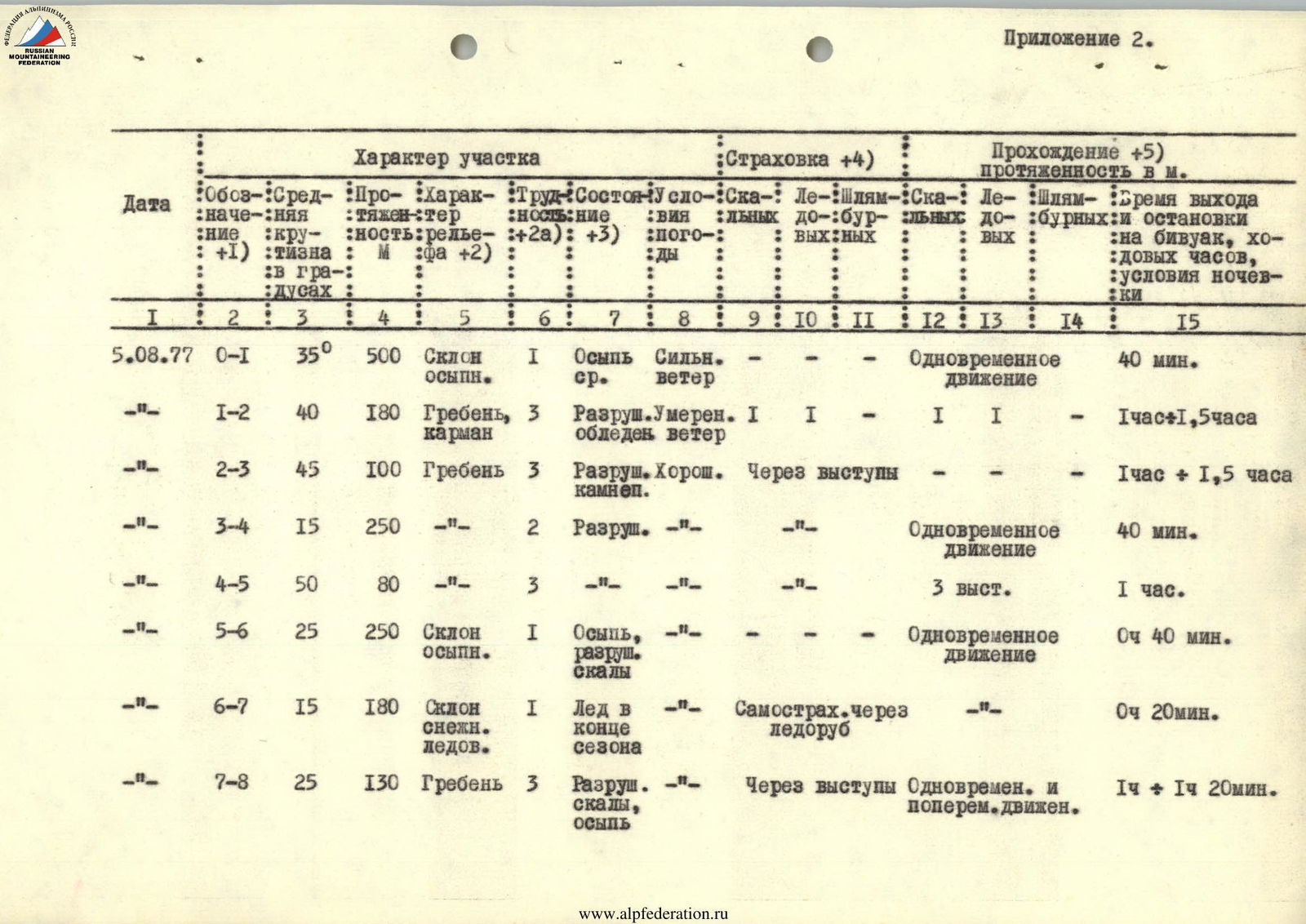
Appendix 2
| Date | Section | Steepness (°) | Length (m) | Terrain characteristics | Cat. diff. of section | Condition | Weather | Pitons (rock) | Pitons (ice) | Pitons (bolt) | Belay / Passage | Time (h, min) / Bivouac conditions |
|---|---|---|---|---|---|---|---|---|---|---|---|---|
| 5.08.77 | R0–R1 | 35 | 500 | Scree slope | 1 | Medium scree | Strong wind | 1 | – | – | Simultaneous movement | 40 min |
| –"– | R1–R2 | 40 | 180 | Ridge, pocket | 3 | Destroyed, icy | Moderate | 1 | – | – | 1 (rock), 1 (ice) | 1 h 30 min |
| –"– | R2–R3 | 45 | 100 | Ridge | 3 | Destroyed, rockfall | Good | – | – | – | Via outcrops | 1 h 30 min |
| –"– | R3–R4 | 15 | 250 | –"– | 2 | Destroyed | –"– | – | – | – | Simultaneous movement | 40 min |
| –"– | R4–R5 | 50 | 80 | –"– | 3 | –"– | –"– | – | – | – | 3 outcrops | 1 h |
| –"– | R5–R6 | 25 | 250 | Scree slope | 1 | Scree, destroyed rocks | –"– | – | – | – | Simultaneous movement | 40 min |
| –"– | R6–R7 | 15 | 180 | Snow-ice slope | 1 | Ice at the end of the season | –"– | – | – | – | Self-belay via ice axe | 20 min |
| –"– | R7–R8 | 25 | 130 | Ridge | 3 | Destroyed rocks, scree | –"– | – | – | – | Simultaneous and alternating movement | 1 h 20 min |
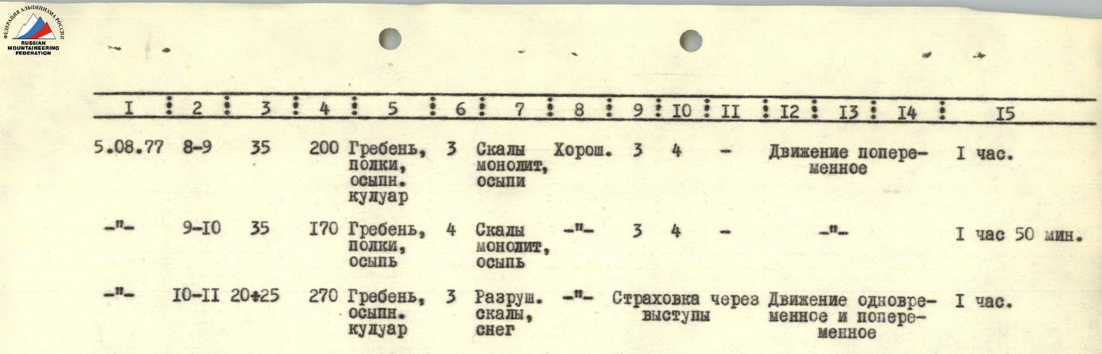
| 5.08.77 | R8–R9 | 35 | 200 | Ridge, ledges, scree couloir | 3 | Rocks, monolith, scree | Good | 3 | 4 | – | Alternating movement | 1 h |
| –"– | R9–R10 | 35 | 170 | Ridge, ledges, scree | 4 | Rocks, monolith, scree | –"– | 3 | 4 | – | –"– | 1 h 50 min |
| –"– | R10–R11 | 20–25 | 270 | Ridge, scree couloir | 3 | Destroyed rocks, snow | –"– | – | – | – | Belay via outcrops, simultaneous and alternating movement | 1 h |
| 5.08.– 6.08.77 | Descent from the summit along the ascent route | 8–9 h |