
- Climbing category: technical
- Climbing area: Alai Range
- Peak: Pik Synovey, height about 5100 m, ascent route - via the North face.
- Estimated difficulty category: 5B
- Route characteristics:
height difference — about 1100 m, average steepness: 55°, length of sections: 2nd cat. diff. — 160 m, 3rd cat. diff. — 190 m, 4th cat. diff. — 300 m, 5th cat. diff. — 590 m, 6th cat. diff. — 40 m.
- Pitons driven: for belaying: rock — 49 ice — 54 bolt — 1 of these for creating artificial holds: rock — 6 ice — 7 bolt — 1
- Number of travel hours: 40 hours
- Number of nights and their characteristics:
- On an ice site in a bergschrund, the site was processed, the tent was set up almost normally.
- On a rock-scree shelf, the site was processed, the tent was set up almost normally.
- On a rock ledge, semi-reclining, wrapped in a tent.
- Full name of the team leader and participants, their qualifications:
- Kozinny Viktor Kirillovich — 1st sports category
- Kozak Leonid Romanovich — Master of Sports
- Smoylovsky Alexander Naumovich — 1st sports category
- Shabokhin Viktor Alekseevich — Master of Sports
- Team coach: Master of Sports Saprykin V.D.
- Date of departure and return:
August 10, 1977 – August 14, 1977
Pik SYNOVEY (5100 m)
Report on the ascent to the peak SYNOVEY via the North face July 10 – July 13, 1977.
- Brief geographical description of the climbing area.
Pik Synovey is located in the Alai Range in the Kosmonavtov horseshoe cirque (Archa-Kanysh gorge area). In the row of peaks in the horseshoe, it is the 2nd from the left and is one of the highest peaks in the cirque along with Pik Titova.
To the north, the base of the peak is adjacent to the flat Kosmonavtov glacier. To the south, the peak descends with heavily destroyed gentle slopes composed of sandstones.
The Kosmonavtov cirque is a very convenient area for mountaineering and will undoubtedly be one of the popular mountain areas among climbers in the future. Eight peaks surrounding the glacier in a semicircle drop to the north with kilometer-high walls. Almost all of them had interesting routes ranging from 3A to 5B–6B difficulty categories laid on them in 1977.
The area has significant advantages:
- Proximity of routes from the base camp on the moraine of the glacier.
- Ability to observe groups on almost all routes in the horseshoe from one point.
- Brief description of the approach to the route.
The base camp of the Dughoba branch tourist camp in the Archa-Kanysh gorge was located approximately in the middle of the gorge, at the mouth of the Tupon gorge leading past Pik Leningradets to the Kosmonavtov cirque.
The approach to the intermediate camp on the moraine of the Kosmonavtov glacier takes about 5 hours. From the camp on the moraine, from where the group was observed, the approach to the route takes 1 hour. The path goes:
- along the moraine rubble,
- then along the flat glacier.
Observation of the route prior to the ascent allowed to establish the main paths of rockfall (to the right of the chosen route, mainly after 15:00), and to outline a safe path through the icefall.
The chosen route, as confirmed by the ascent, is apparently the safest and most logical path to the summit via the north face. Alai Range, Archa-Kanysh gorge.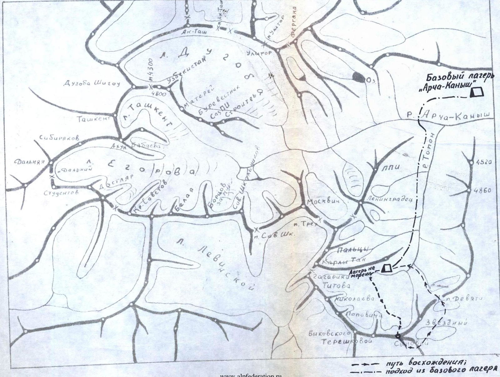
Brief explanation for the table (description of the ascent)
July 10
Departure from the camp on the moraine of the Kosmonavtov glacier at 6:00. The approach under the icefall descending from the north face of the peak takes about an hour.
The route goes through the right part of the icefall. At point R0, we put on crampons and rope up. The section R0–R1 is traversed simultaneously. All subsequent sections involve complex ice terrain requiring the climbers' highest ice climbing skills.
Immediately on the section R1–R2, complex work begins. The ice slope becomes steeper at 45°, and the last 8 m are at 60°. We have to cut steps. Belaying is with pitons, using a rope railing. At the end of the section, there is a ledge.
From the ledge, we climb up through a steep ice chimney. The chimney is traversed with the help of two ladders and a rope railing. Further movement is alternating on a slope broken by crevasses at 45°. The steepness increases. A 3-meter wall at 70° is overcome through an ice chimney using a ladder and rope railing.
Further, the path goes along a slope at 45°, cut by crevasses. An ice wall is bypassed on the left (section R5–R7). First, a wide crevasse is overcome via a snow bridge, then ascent up a snow slope at up to 60°. Belaying is through an ice axe. We reach a flat ledge, which is a snow bridge over a large bergschrund. A possible overnight site.
A 2-meter negative wall of the bergschrund is climbed with the help of a ladder, and we approach a second bergschrund along a snow slope.
Due to the lack of suitable sites on the slope above and the increasing rockfall danger after 15:00 (when the sun illuminates the slope), we decide to stop movement at 15:00. The site in the bergschrund is reliably protected from possible rockfall from above. We cut out a site on the ice, organize an overnight stay. Simultaneously with setting up the bivouac, we process another 120 m of snow-ice slope at 45° and hang rope railings. On the first day, 340 m of complex ice terrain on the icefall is traversed, and 120 m of snow-ice slope is processed.
July 11
We depart at 7:00. After overcoming a 2-meter negative wall of the bergschrund with a ladder, we traverse along the hung ropes. Along a steep, crevassed ice slope, we approach a third bergschrund.
To the right, there is a rockfall-prone gully, where rockfall is possible after 15:00.
From the bergschrund, after overcoming a 3-meter wall with a ladder, we traverse the gully to the right, exiting into the last bergschrund directly under a rock island shaped like a trident (with its prongs pointing down). On the traverse, we have to cut steps — 10 m.
The gully is rockfall-prone. The most likely time for rockfall is after 15:00.
To the rocks, we climb up to the right along an ice slope at 70°, first overcoming a 2-meter negative wall with a ladder. The ice is very dense, breaking off in large "lenses," and pitons are difficult to place. The entire ice section when exiting to the rocks is traversed with step-cutting in a closed stance. The rocks are complex, with a steepness of 75–80°.
On the rocks, movement is vertically upwards along a wall (6 m), then along the left side of an internal corner (10 m). The rocks are difficult, climbing is tense, and belaying is with pitons. Rucksacks have to be pulled up the full 40 m.
From the internal corner, we exit onto steep, destroyed, and iced rocks, partially covered with snow. Movement is cautious to avoid dislodging rocks. To the left along the internal corner, we exit onto a rock ledge in the center of the "trident" — on the ledge, we build a control cairn.
From the ledge, along the internal corner (20 m) at up to 70°, we climb up destroyed rocks filled with ice. We exit onto a snow ridge with rock ledges on the left. On one of the ledges, we set up an overnight stay, preparing a site for the tent. The bivouac is normal.
On the second day, 280 m is traversed. One of the most complex sections of the route (R10–R11) — a steep slope of dense ice, and (R11–R12) — a complex rock wall — is overcome.
July 12
Departure at 8:00. From the overnight site, the path goes along a gentle ridge (40 m at up to 30°). On the ridge, we overcome a 2-meter rock couloir filled with ice. A rock pinnacle on the ridge is bypassed on the right along destroyed, iced rocks. Beyond the pinnacle, we exit onto a steep rock ridge (60 m). The rocks are like "ram's foreheads" often filled with ice. To the right, in close proximity, there is a rockfall-prone gully (rockfall possible after 15:00).
From the ridge, through a 1.5-meter chimney, we exit onto heavily destroyed rocks to the right of a clearly defined "bastion." On the rocks, there is snow.
Along complex rocks, vertically upwards under the red monolithic walls of the "bastion" (80 m). Climbing is tense. Along the red walls, on snowy rocks, we exit into a wide chimney.
From the chimney, a traverse to the right upwards along rocks filled with ice at 80° (5 m) using a ladder, and then vertically upwards (80 m) along a wide internal corner filled with ice. In places, we have to overcome chimneys with "plugs." In some areas, the steepness of the rocks reaches 90°. Climbing is very difficult, using artificial holds.
Along the internal corner, we exit onto a small safe ledge before a steep, ice-filled wall. The last 40 m, rucksacks are pulled up.
Due to the significant physical and psychological load of the day, at 17:00, it is decided to set up a bivouac. On the ledge, 2/3 of the tent fits, so the night is spent in a semi-reclining position.
On the third day, 310 m is traversed. The most complex section of the route is behind: the exit to the "bastion."
Ahead:
- a vertical 40-meter wall,
- completely filled with ice.
July 13
We depart on the route at 7:00. Climbing is very difficult. In two places, we use ladders, and one bolt piton is driven. In the upper part, there is an exit along an internal corner filled with ice, to the left onto a ledge. Rucksacks are pulled up. On the ledge, a bivouac is possible.
From the ledge, to the right along an ice slope, we exit onto a snow pre-summit ridge. Movement is in crampons on the front teeth. The ridge is rock-ice. Small ice walls on the ridge are overcome with step-cutting.
Two rock pinnacles of medium difficulty are overcome head-on.
On the ridge, there are places for overnight stays.
The last 60 m are traversed on the right side of the ice "knife-edge," where the slope steepness increases from 50° to 60°. On the last 5 m, the slope steepness reaches 70°. Movement is initially on the front teeth of crampons, and the last 20 m — with step-cutting.
At 16:45, we exit onto the main ridge of the peak. Along scree to the left, bypassing a pinnacle on the right in the course, after 80 m, we reach the cairn on the summit.
On the last day, 310 m is traversed. The most complex sections:
- (R15–R16) — a vertical, ice-filled wall
- Steep exit to the main ridge of the peak.
Descent from the summit is via the southeast edge and a ridge connecting to the east ridge branching off from Pik Synovey. From the ridge connecting the peaks, three sports descents of 40 m each are made, then descent along ledges into the Sauk-Jailau gorge. Return to the camp in the Kosmonavtov cirque is through the Devyatka pass.