Climbing Passport
I. Climbing category — technical. 2. Climbing area — Tian Shan, Chatkal Range. 3. Climbing route — to v. Bolshoy Chimgan via the northwest wall, peak height — 3207 m above sea level. 4. Climbing characteristics: — height difference — 1500 m, — average steepness — 65°, — length of the difficult section — 600 m. 5. Pitons hammered: — rock — 55 — ice — — bolt — 6. Number of travel hours — 15. 7. Number of nights and their characteristics — without nights. 8. Team name — CS DSO "Mehnat". 9. Surname, initials of the leader, participants, and their qualification:
- Zhirnova F. Yu. — 2nd category.
- Valeev N. — 2nd category.
- Zhirnov V. A. — 1st category.
- Perziger F. I. — CMS.
- Team coach — Tysyachnaya G. G.
- Dates of departure and return — May 4, 1979 – May 4, 1979.
DESCRIPTION OF THE CLIMBING ROUTE
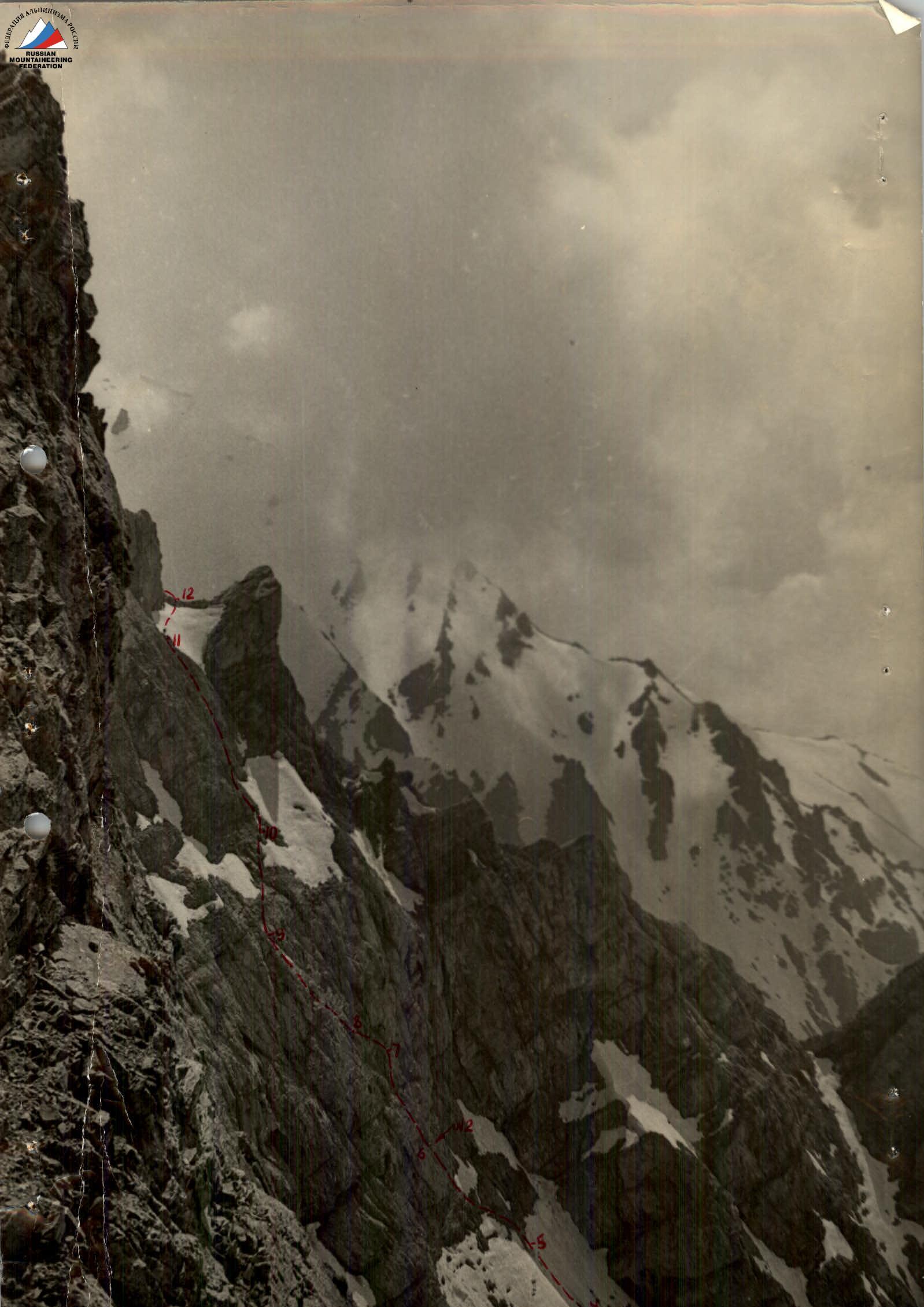
to v. Bolshoy Chimgan via the northwest wall. From the camp in the tract of 12 springs, down the road and to the right into the gorge of the Koksay River. 1 km upstream along the say, and then — along the avalanche to the upper reaches in the direction of the inner corner formed by the NW wall and the Central ridge. In the upper part under the wall, the steepness of the dense frozen snow increases to 60°, there are rock islands (150 m, 60°). In a deep grotto in front of the rock ledge — control cairn No.1. Up the monolithic wet rocks, with sand, holds outside (40 m, 85°), to the left — sheep's backs, and to the right — eaves of the Central ridge. Inclined traverse to the left along strongly destroyed rocks (20 m, 45°) to monolithic shelves, along them up climbing of medium difficulty, but on the shelves — small stones (80 m, 60°). 40 m up the very steep snow up to 70°, at the contact of which with the rocks — accretion ice. Up to this place, the movement went almost parallel to the inner corner, now — 70 m to the left up the rocks of the "sheep's backs" type (at the end of the section — control cairn No.2) in the direction of a vaguely expressed ridge, behind which along the inner corner 40 m of very complex rocks with an overhang in the upper part. Then 40 m of almost horizontal traverse to the left to inclined shelves (using a pendulum), along which to a monolithic ridge, along it 60 m up. Under a small snow patch to the right — up with an exit to strongly destroyed rocks, along them 80 m, 75° up along the left side of a wide couloir with snow plugs. The couloir leads to a wide snow area, from which 40 m to the right along the upper snow plug to the Central ridge under its second jendarmer. Along the right wall of the jendarmer to control cairn No.3 (it is also cairn No.2 of the route 2B cat. diff. along the Center ridge). From the cairn — up along the ridge and to the right along the ridge of the mountain massif to the summit. On the traverse of the ridge, the main difficulty — 2 descents of 30 m by sports method. Descent along the western ridge along the route 1B cat. diff.
Conclusions
The wall part of the route is very cold and is lit by the sun only in its upper third at sunset. Passage and organization of belay are complicated by almost complete absence of ledges and deep crevices, as well as alternation of rock sections with snow. Movement is everywhere alternating, and belay is exclusively piton. It is recommended to plan: — an overnight stay — or an early exit at 3–4 am. Not recommended as the first route of 4th cat. diff.
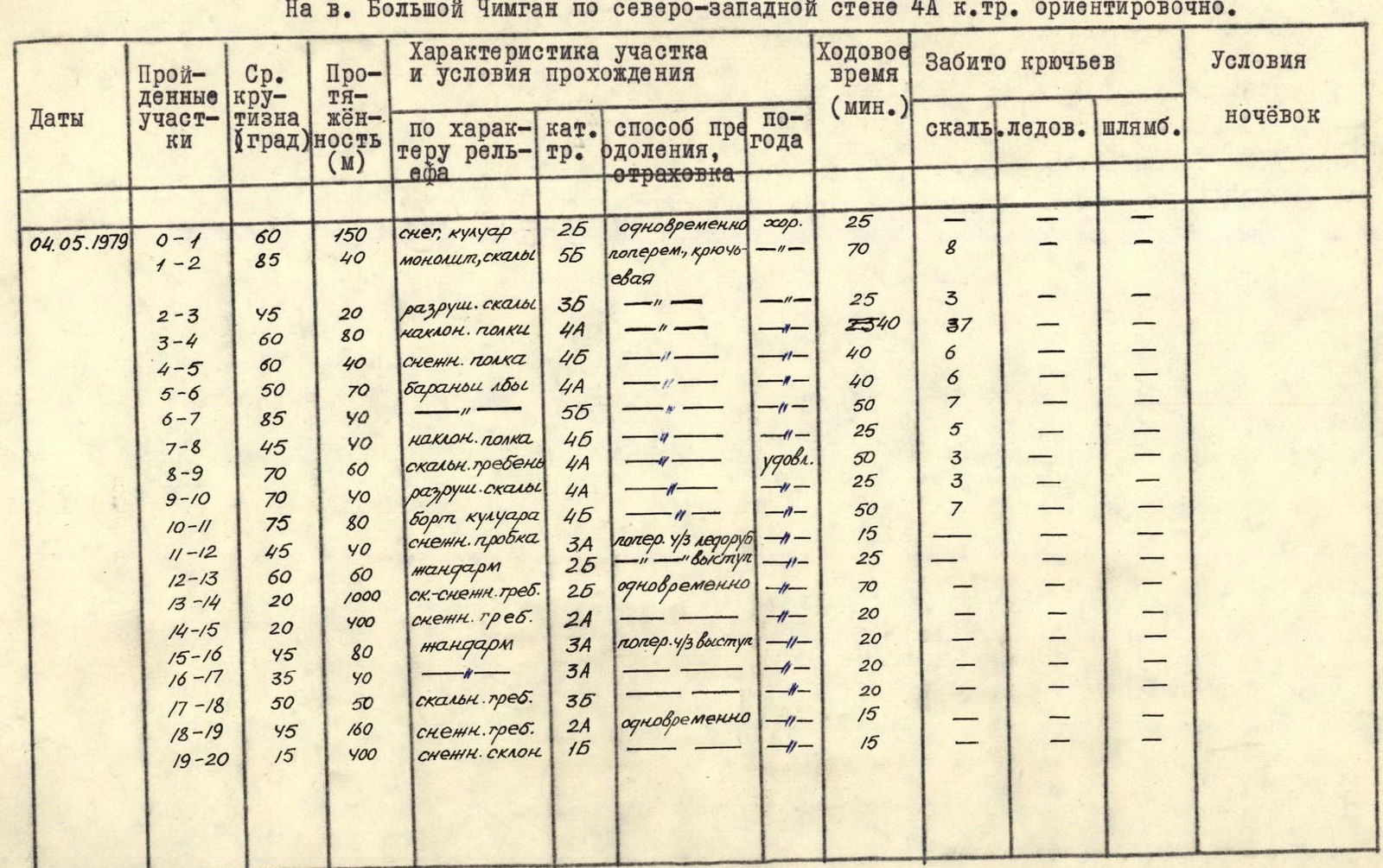
Table of main characteristics of the climbing route
To v. Bolshoy Chimgan via the northwest wall 4A cat. diff. approximately.
| Dates | Passed sections | Average steepness (°) | Length (m) | By relief character, cat. diff., overcoming method, belay | Travel time (min.) | Pitons hammered: rock | Pitons hammered: ice | Pitons hammered: bolt | Overnight conditions |
|---|---|---|---|---|---|---|---|---|---|
| 04.05.1979 | R0–R1 | 60 | 150 | snow, couloir, 2B, simultaneous, good | 25 | 7 | — | — | — |
| R1–R2 | 85 | 40 | monolith, rocks, 5B, alternating, piton | 70 | 8 | — | — | — | |
| R2–R3 | 45 | 20 | destroyed rocks, 3B | 25 | 3 | — | — | — | |
| R3–R4 | 60 | 80 | inclined shelves, 4A | 25–40 | 37 | — | — | — | |
| R4–R5 | 60 | 40 | snow shelf, 4B | 40 | 6 | — | — | — | |
| R5–R6 | 50 | 70 | sheep's backs, 4A | 40 | 6 | — | — | — | |
| R6–R7 | 85 | 40 | —, 5B | 50 | 7 | — | — | — | |
| R7–R8 | 45 | 40 | inclined shelves, 4B | 25 | 5 | — | — | — | |
| R8–R9 | 70 | 60 | rocky ridge, 4A, satisfactory | 50 | 3 | — | — | — | |
| R9–R10 | 70 | 40 | destroyed rocks, 4A | 25 | 3 | — | — | — | |
| R10–R11 | 75 | 80 | couloir side, 4B | 50 | 7 | — | — | — | |
| R11–R12 | 45 | 40 | snow plug, 3A, alternating, ice axe | 15 | — | — | — | — | |
| R12–R13 | 60 | 60 | jendarmer, 2B, ledge | 25 | — | — | — | — | |
| R13–R14 | 20 | 1000 | rocky-snowy ridge, 2B, simultaneous | 70 | — | — | — | — | |
| R14–R15 | 20 | 400 | snowy ridge, 2A | 20 | — | — | — | — | |
| R15–R16 | 45 | 80 | jendarmer, 3A, alternating, ledge | 20 | — | — | — | — | |
| R16–R17 | 35 | 40 | —, 3A | 20 | — | — | — | — | |
| R17–R18 | 50 | 50 | rocky ridge, 3B | 20 | — | — | — | — | |
| R18–R19 | 45 | 160 | snowy ridge, 2A, simultaneous | 15 | — | — | — | — | |
| R19–R20 | 15 | 400 | snowy slope, 1B | 15 | — | — | — | — |