Description of the First Ascent Route to Peak Bolshoy Chimgan via the Left Counterfort of the Wall, Category 3B
February 6, 1978
We depart from the base camp located in the Ak-Sai valley at 10:00. We ascend to the Western Ridge via a Category 1B route. Upon reaching the junction of the Western Ridge and a false ridge (joining from the right), we descend with a slight traverse of the Western Ridge towards the summit.
Descending into the Belder-Sai valley, we move upstream until the confluence of three couloirs. We continue up the left couloir.
Approaching the wall, it's easy to identify the counterfort, which the route follows, forming the right side of the central couloir that divides the entire Belder-Sai rock massif into two parts.
The route begins from a cave located at the boundary between snow and rock, one rope length away from the left edge of the counterfort. The cave provides a good overnight stay and has a guiding cairn.
The entire approach took 9–10 hours.
February 7, 1978
Departure at 9:30.
R1
- From the cave, move 2–2.5 m to the right (facing the wall) to an internal corner.
- Then climb directly up the internal corner to a ledge.
This is a key section. The length is 2 rope lengths. Climbing is challenging. Snow. Average steepness is 75°. The ledge is Category 1 difficulty.
R2
- From the ledge, climb directly up smoothed rocks to an inclined ledge — 1 rope length.
- Then climb up a slab 5–6 m to an internal corner.
- Up the internal corner (2–2.5 m) to a convenient protrusion.
- Then up and left to a scree ledge.
The length is 1.5 rope lengths. Climbing is of moderate difficulty.
From the belay point:
- Move right and up under an overhanging wall (photo 4).
- Traverse it from left to right to reach a convenient platform (ledge).
- From the platform, climb directly up to a horseshoe-shaped ridge.
The length of R2 is 4 rope lengths. Average steepness is 70°.
R3
- On the horseshoe-shaped ridge, there are three gendarmes. The first is bypassed on the left, the second and third are taken head-on. The average height of the gendarmes is up to 6 m. The ridge transitions into a rock bastion, which in its upper part forms a rock rib. Moving along the right side of the bastion, near the rib, on smooth, gentle slabs without gaining height, we reach a steep, snowy couloir. It's wide at the bottom and narrows at the top. Climbing up the couloir for 1.5–2 rope lengths, we reach a steep rock rib forming the right side of the couloir. In the lower part of the rib, there's a spot for the entire group to assemble. Movement is in connected teams, simultaneous and alternating. Belaying is through protrusions and ice axe. Average steepness is 20°.
R4
Climb up steep snow covering the rib to approach a rock step 2 m high, with a steepness of 90°. Pass the step and climb up destroyed rocks covered in snow to reach two 40 m rope lengths. At the end of the second rope length, there's a convenient spot for organizing a belay point. It's undesirable to have more than two people at the belay point.
The second 80 m of the section is similar in character to the first. Exit onto a convenient platform where a tent was set up.
This section is key.
- Average steepness: 70°
- Length: 4 rope lengths
- Terrain: destroyed rocks
- Cover: snow
February 8, 1978
R5
From the platform on the ridge, move up, bypassing all rock gendarmes on the right. Reach the confluence of three ridges:
- Belder-Sai ridge;
- ridge from the Western wall;
- summit ridge.
Movement is in connected teams, simultaneous. Deep snow. Belaying through ice axe.
R6
From the confluence, move along the summit ridge towards the summit. On the way:
- Two gendarmes are bypassed on the right.
- Movement is simultaneous, in connected teams.
- Belaying through ice axe.
- Deep snow.
Descent is via the Category 1B route on the Western Ridge. The entire descent took 4 hours.
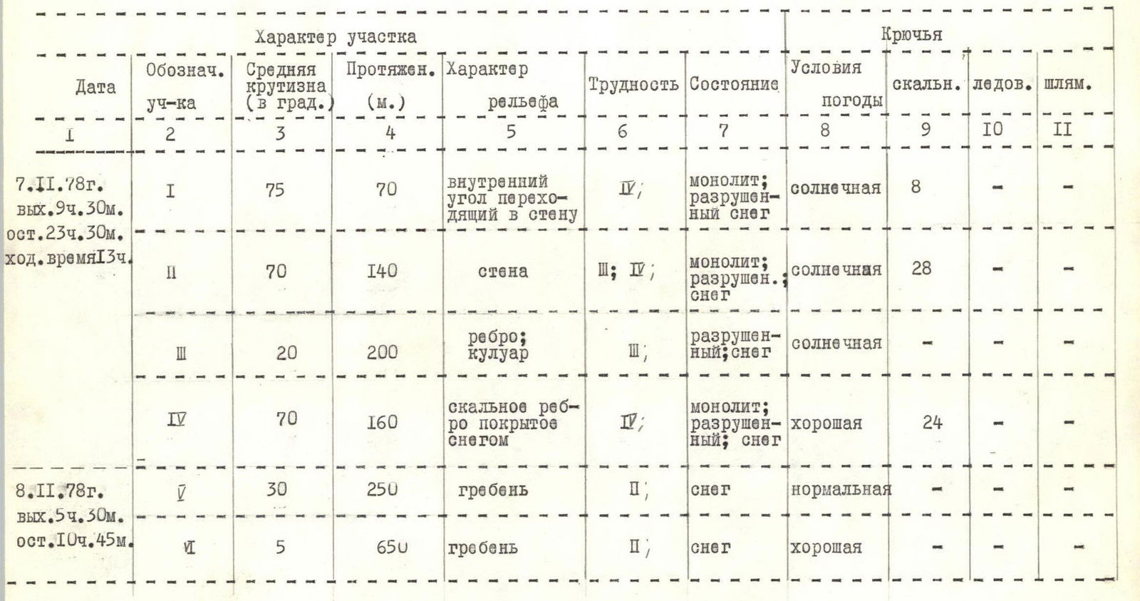
| Date | Pitch Label | Average Steepness (degrees) | Length (m) | Terrain Description | Difficulty | Condition | Weather Conditions | Rock | Ice | Shlam |
|---|---|---|---|---|---|---|---|---|---|---|
| February 7, 1978 | R1 | 75 | 70 | internal corner turning into a wall | 4 | monolithic; destroyed snow | sunny | 8 | - | - |
| Departure: 9:30 | ||||||||||
| Stop: 23:30 | R2 | 70 | 140 | wall | 4 | monolithic; destroyed snow | sunny | 28 | - | - |
| Climbing time: 13 hours | ||||||||||
| R3 | 20 | 200 | rib; couloir | 3 | destroyed; snow | sunny | - | - | - | |
| R4 | 70 | 160 | rock rib covered in snow | 4 | monolithic; destroyed; snow | good | 24 | - | - | |
| February 8, 1978 | R5 | 30 | 250 | ridge | 2 | snow | normal | - | - | - |
| Departure: 5:30 | ||||||||||
| Stop: 10:45 | R6 | 5 | 650 | ridge | 2 | snow | good | - | - | - |
 |
Approach to the Route