
MINISTRY OF SPORT, TOURISM AND YOUTH POLICY OF KRASNOYARSK TERRITORY
KRASNOYARSK TERRITORY SPORTS FEDERATION OF ALPINISM
RUSSIAN CHAMPIONSHIP 2013
Class of High-Altitude Ascents
Report
Of the combined team of Krasnoyarsk Territory on the ascent to Khan-Tengri peak via the south wall of the southwest counterfort (variant of the route by Sviridenko) 6B category of complexity.
Passport of the Ascent
-
Region — Central Tien Shan, Tengri-Tag ridge, 7.9.18.
-
Peak — Khan-Tengri 6995 m, via the south wall of the southwest counterfort (variant of the route by Sviridenko).
-
Category of complexity — 6B.
-
Nature of the route — combined.
-
Characteristics of the route:
height difference of the route — 2500 m, height difference of the wall part of the route — 1500 m, length of the route — 3500 m, length of sections 6 — 400 m, 5 — 1150 m, average steepness of the route — 55°.
-
Left on the route: pitons — 5; including stationary pitons — 0
Pitons used on the route:
- stationary pitons — 1 (found on an intermediate station).
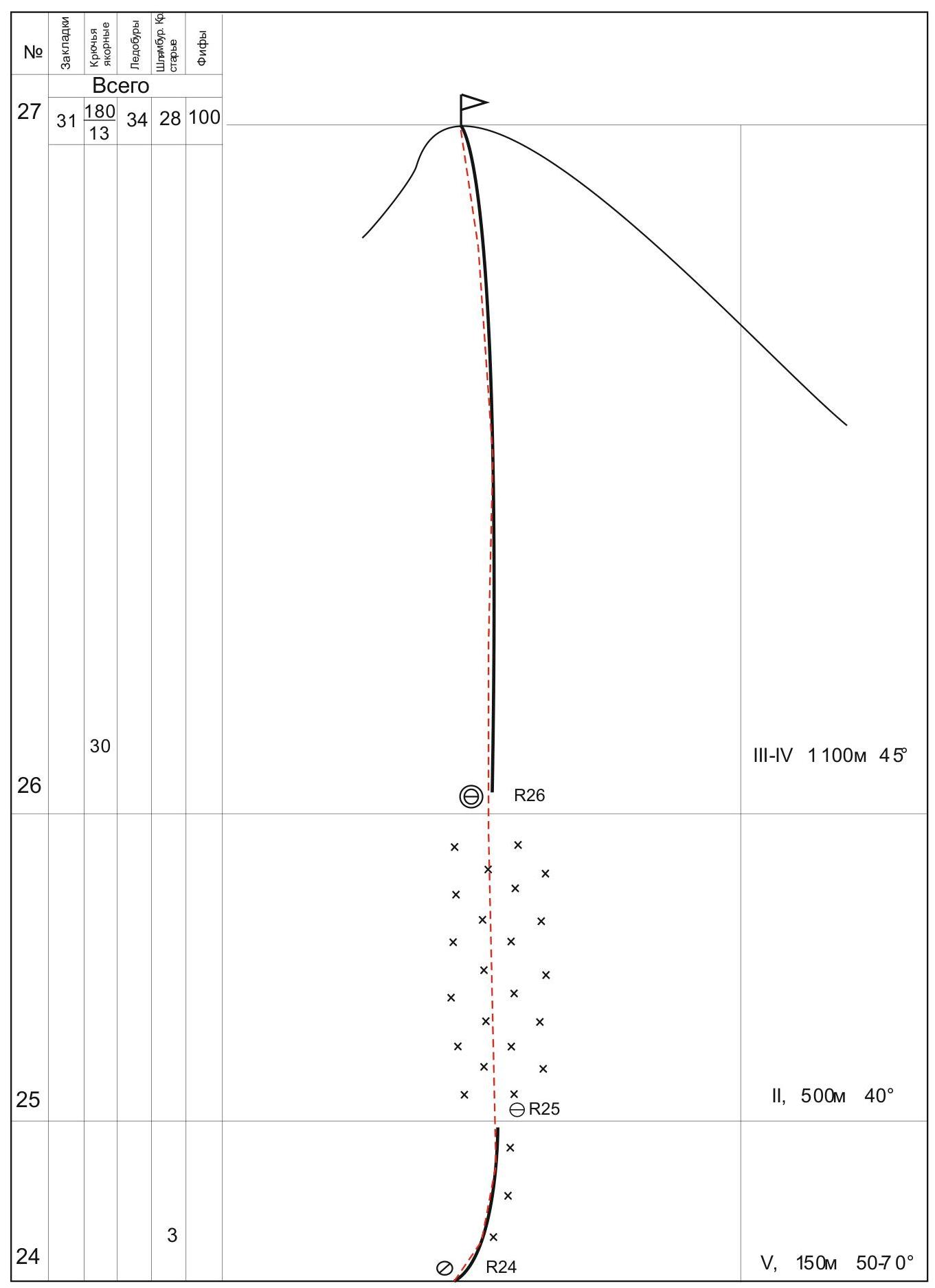
- anchor pitons — 180, chocks — 31, ice screws — 34, snow anchors — 28
Total number of used T.A. ≈ 150.
-
Number of travel hours — 54, travel days — 5.
-
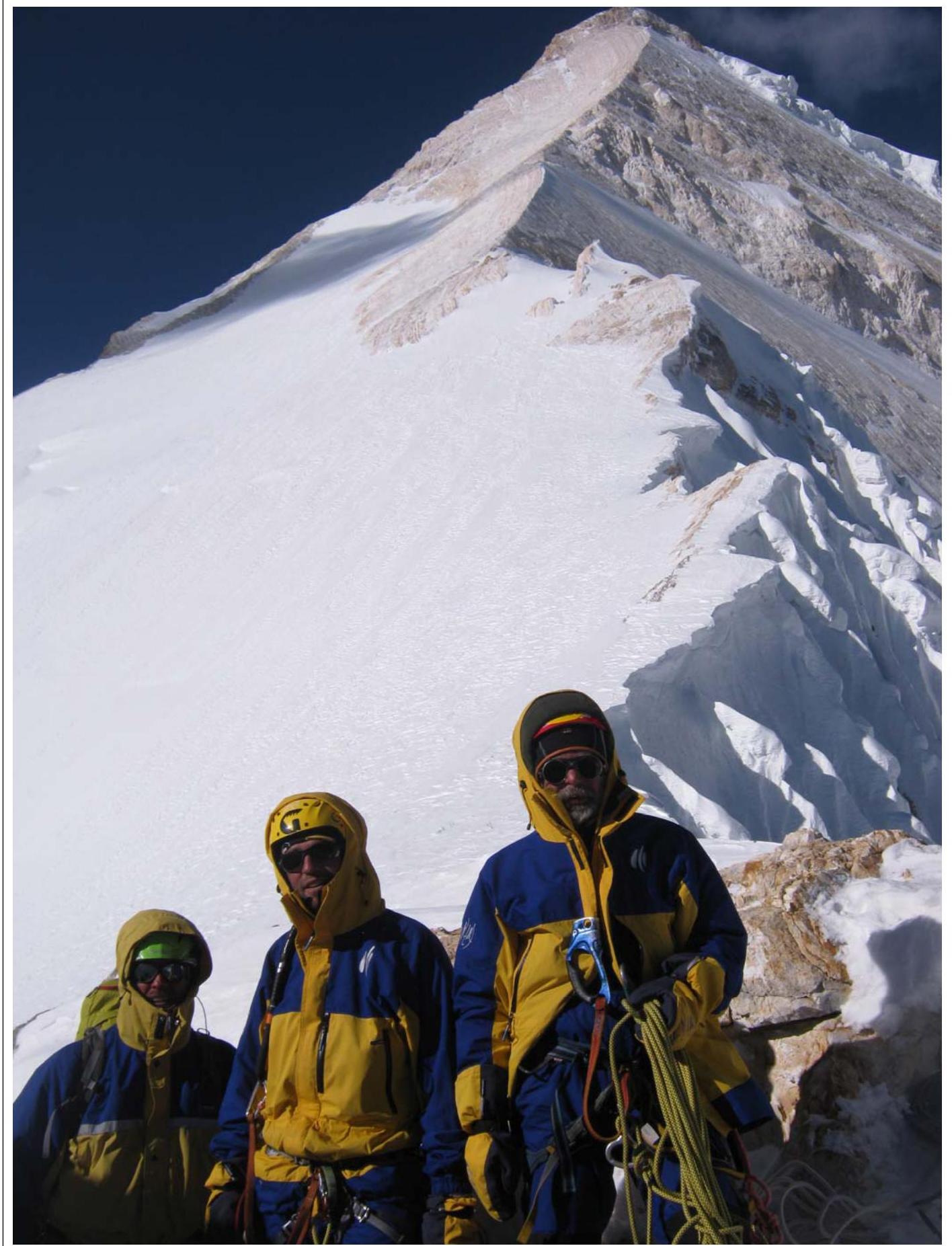
Team leader — Pugovkin Anton Nikolaevich Master of Sports
Team members:
- Yanushevich Alexander Arturovich Master of Sports
- Kalita Georgy Vasilyevich Candidate for Master of Sports
- Zhigalov Alexander Vladimirovich Candidate for Master of Sports
-
Team coaches: Zakharov Nikolai Nikolaevich International Master of Sports, Honored Coach Balezin Valery Viktorovich International Master of Sports
-
Departure date:
for the ascent — August 15, 2013 to the summit — August 19, 2013 at 17:00; return — August 20, 2013 at 7:00 (to Base Camp on South Inylchek Glacier).
-
Organization: Krasnoyarsk Territory Sports Federation of Alpinism 2013
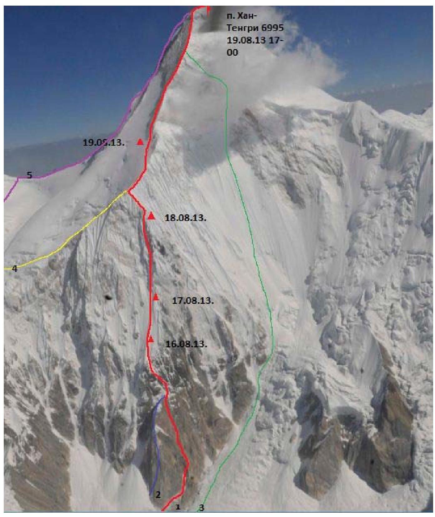
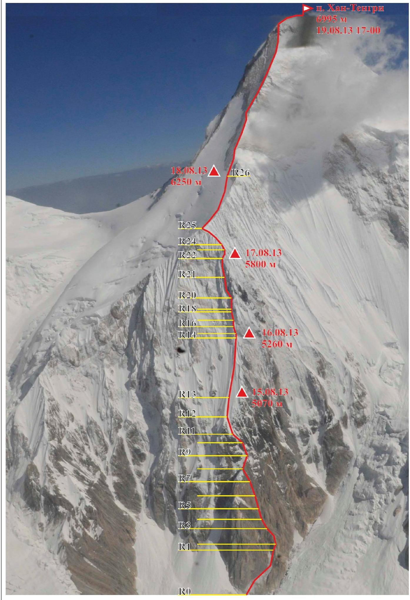
General photo of the summit (photo by G. Sokolov from a helicopter)
- team's route via the south wall of the SW edge
- route via the SW counterfort of the SW edge, 6B category of complexity (V. Sviridenko)
- route via the S. wall, 6A category of complexity (G. Isachenko)
- route via the left part of the SW bastion and SW edge 5B category of complexity (B. Romanova)
- descent path from the summit

Route profile 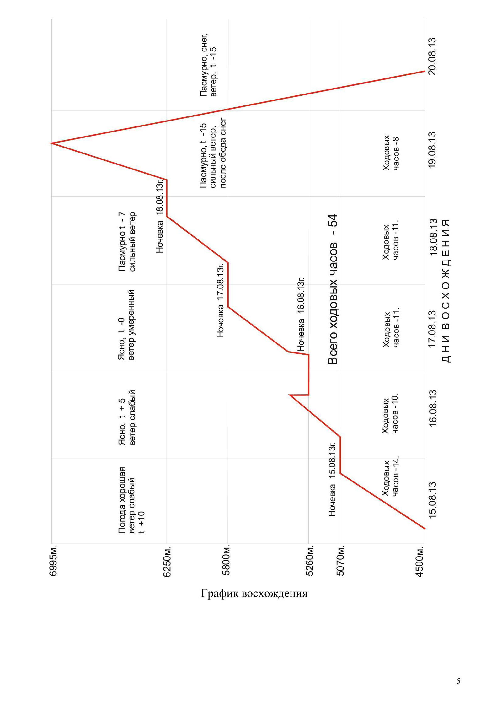
Tactical Actions of the Team
The main task of this ascent was to pass a complex high-altitude and technical route with high speed, if possible, with a passage of a new part of the wall on the right. To solve this task, the following measures were taken:
- Maximum possible weight reduction. "Everest 96" tent (manufactured by Rock-Pillar) — weight without poles (used 4 ski poles as poles) 2 kg; everyone had shortened "Noga" sleeping bags with tinsulate insulation (manufactured by Rock-Pillar), used on overnight stays together with insulated jackets (manufactured by Red Fox), use of 3 sleeping mats for 4 people.
- Optimization of food in terms of using ready-made packets that only required pouring boiling water over the contents, which allowed for maximum economy on food preparation and almost no limitation on melting snow for drinking. It is worth noting Italian-made energy gels, gel-like contents (50g packet) were mixed with water and drunk instead of tea, noticeably replenishing the loss of fluids, allowing to drink faster.
- Equipment: very high efficiency of anchor pitons was noted, additionally took a set of chocks and 4 medium excentrics, but on the route, it was possible to do without them. 5 snow pitons did not find their application due to their extreme inefficiency in the snow on the route. Mandatory use of a good snow shovel, without it, passing some sections of the snow knife and the entire corniced ridge is impossible!
- Uniform distribution of work among the three participants on the route as the first, taking into account the physical condition of each. Application of simultaneous movement and belay technique on rocks of medium complexity (second belays the first through Grigri, while ascending in parallel along fixed ropes to an intermediate station).
- Planned, step-by-step acclimatization, including: ascent to "Uchitel" peak (Ara-Archa valley, before flying to South Inylchek Glacier), three subsequent acclimatization exits, with the highest overnight stay at 6400 m, and the team climbed there in one day from Camp 1.
- Observation of the route from different angles for a long time, waiting out bad weather and subsequent exit on the route in the most comfortable weather conditions.
The initial tactical plan assumed that the route would be passed in 5 days in the following order:
On the first day, it was planned to pass the rock triangle and the entire snow knife and stop for the night under the rocks. Second day — passage of part of the wall to the "black rocks". Third day — completion of work on the wall and exit to the ridge and beginning of work on it. Fourth day — passage of the ridge and overnight stay under the "Klyk" gendarme. Fifth day — ascent to the summit.
But we underestimated the rock part, and instead of reaching the top of the triangle at 14:00, the team reached it at 16:00, thus, the remaining daylight was not enough to pass the entire knife, and at 20:00 we stopped for the night and spent 2 hours digging a place for the tent in the ice, which subsequently shifted our schedule, forcing us to stop for the second overnight stay on the knife at noon the next day, but it allowed us to process part of the wall and overnight on a comfortable ledge, and the next day we reached the planned place of the third overnight stay. Further movement was according to plan. The presence of rappel ropes along the entire path from the summit to the 6100 m saddle allows for confidently planning an ascent to the summit in the evening and subsequent descent, down to the base camp, which we did, since it was planned that on August 20, 2013, at 7:00 a helicopter would arrive for us.
From the features of the route, the following should be noted:
- A rather rockfall-prone lower section of the wall.
- Presence of water (in sunny weather) up to the rock triangle, almost up to 5000 m.
- Need to pass the snow knife in the evening and morning, otherwise the snow becomes slushy.
- Bypassing sections of steep flow ice with problematic belay in the upper part of the wall, along rocks using Fifi hooks and reliable belay with anchor pitons.
- Use of a snow shovel on the corniced ridge and mandatory change of the leader after passing 50 m.
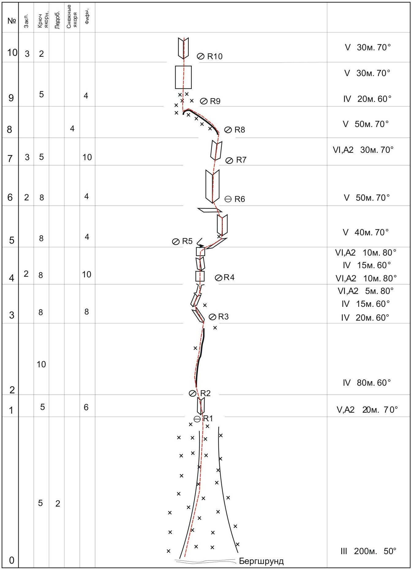
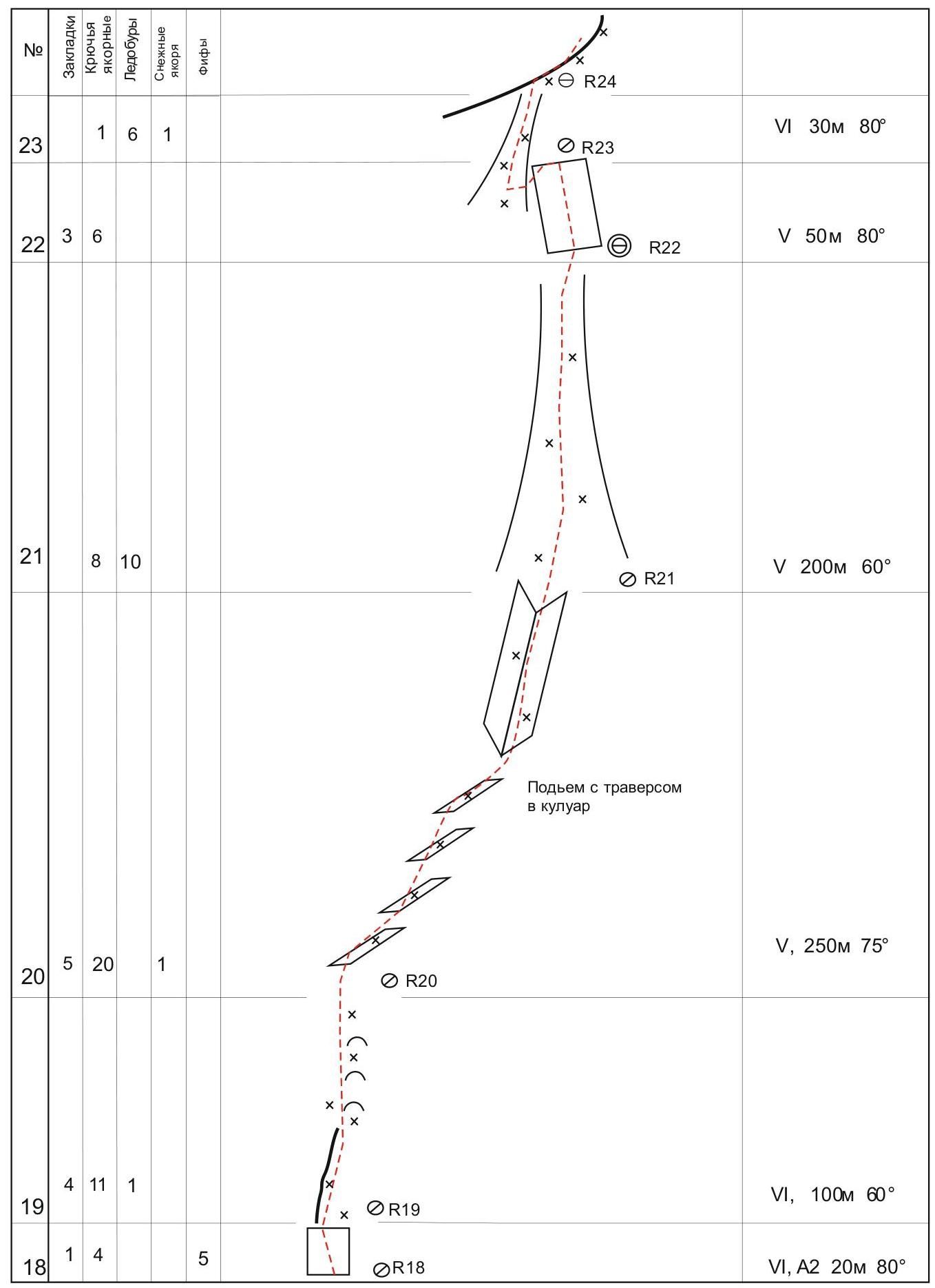
Route scheme in UIAA symbols
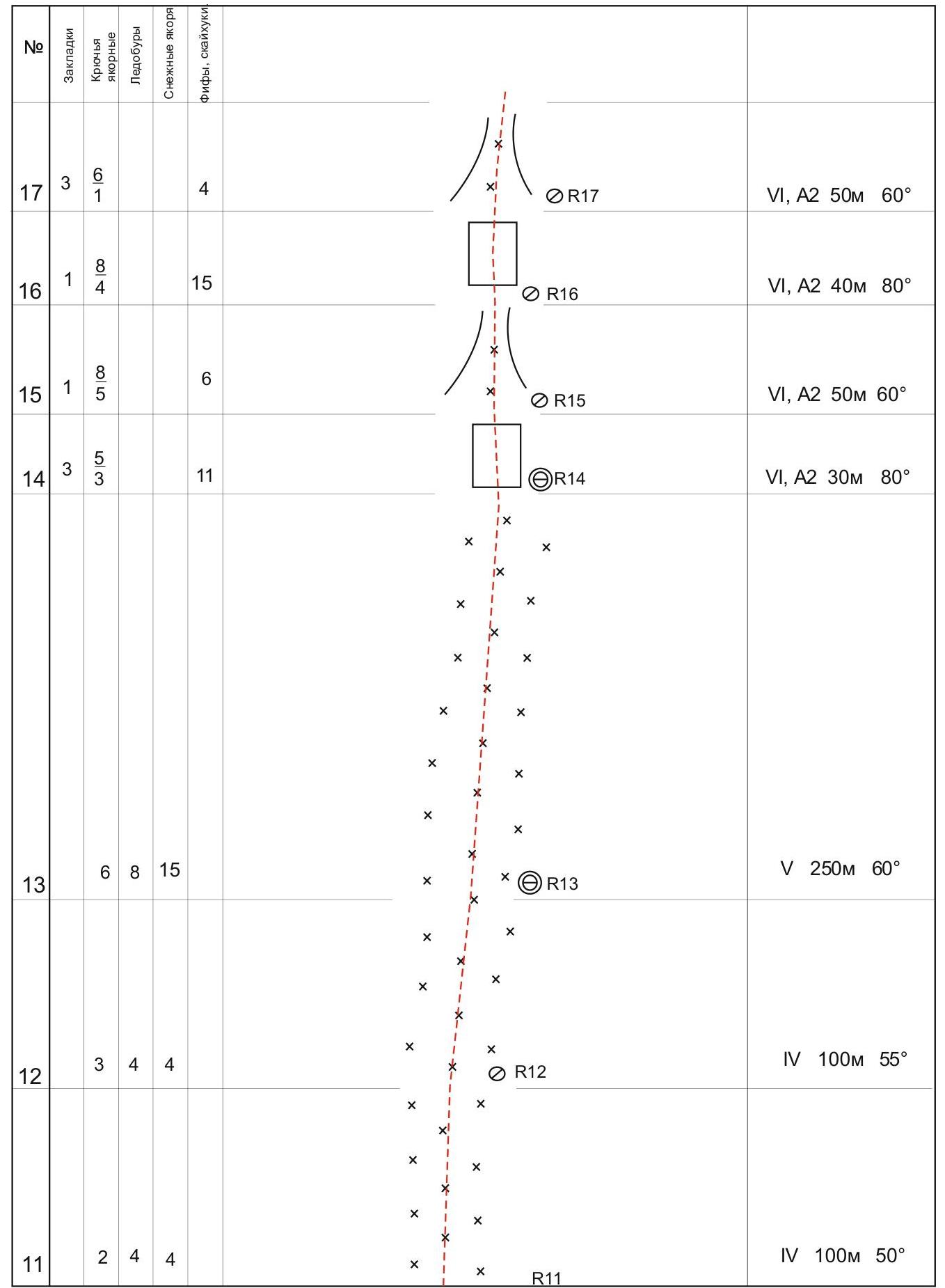
Continuation of the route scheme in UIAA symbols
Continuation of the route scheme in UIAA symbols
Continuation of the route scheme in UIAA symbols
Description of the Route by Sections
0–1. Snow-ice slope, belay on rocks to the left. 1–2. Up the internal corner, to a small saddle. 2–3. Up to the left along a weakly expressed counterfort. Simultaneous climbing (second belays the first through Grigri, while ascending in parallel along fixed ropes to an intermediate station). 3–4. Internal corner, up-left. Internal corner, up-right. Chimney. 4–5. Wall, complex belay. Internal corner. Wall, complex belay. Descent pendulum to the right, to a ledge. 5–6. Along an oblique ledge up to the right to the base of an internal corner. Attention, very oblique perils! Up the internal corner to the left:
- Ledge, on it a convenient station.
- 6–7. Internal corner, easy climbing.
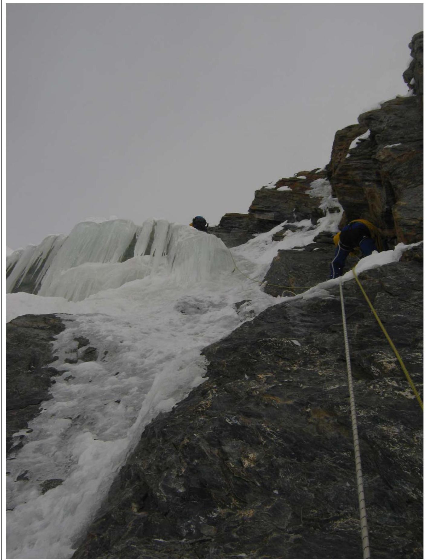
- 7–8. Internal corner, complex climbing, as there are thin flows of ice, rocks are destroyed.
8–9. Traverse along the ridge towards the saddle. Attention, belay is difficult to organize!
9–10. Up and slightly to the right along deep snow under the rock wall. Strongly destroyed wall with individual blocks, up-right, then left to the base of an internal corner.
10–11. Destroyed internal corner, many jammed blocks, be careful!
11–12. Along snow with ice, along embedded stones, belay on them with anchors.
12–13. Along snow with ice, belay on ice screws. Overnight stay 1.
13–14. Along snow with ice, belay on ice screws and snow pitons (not reliable!), in places the slope becomes up to 80°, have to dig with a shovel! Choose a direction along small couloirs, where snow is denser, do not climb onto the ridge of the knife, it's very loose! To a rock wall, there is a large snow "mushroom", after removing the top with a shovel, got an excellent overnight stay!
14–15. Up the left part of the steep wall towards the snow ridge.
15–16. Along a snowy couloir to the beginning of rock outcrops.
16–17. Steep rock wall.
17–18. Weakly expressed couloir, rather a passage between snow ridges, iced rocks.
18–19. Steep wall, direction up and slightly left towards a small ridge.
19–20. Along the right (by the way) side of the ridge up to a steep rock rise. Belay on rock outcrops.
20–21. Traverse with descent to the right, towards an internal corner, on the right wall an old piton is hammered! Station higher, on a flattening at the beginning of a snow-ice couloir.
21–22. Up the snow-ice couloir towards the ridge. Belay on ice screws and rock outcrops. Station on a rock ledge, many old embedded ropes.
22–23. From the station up-left along the wall of the ridge, there is a hole in the snow ridge, through which you need to climb to the other side of the ridge.
23–24. Descent to the other side of the ridge at the base of a steep ice couloir along a system of steep couloirs, clogged with large snow-ice cornices, up, to the right onto the ridge. Attention, snow cornices and "mushrooms" are very unreliable, two cases of collapse under the first.
24–25. Along the snow ridge, in places very steep with very loose, over-frozen snow. The first works with a shovel, no belay, stations on himself.
25–26. Along a snow-ice field, along the ridge towards the gendarme.
26–27. Rock ridge, going up to the summit.
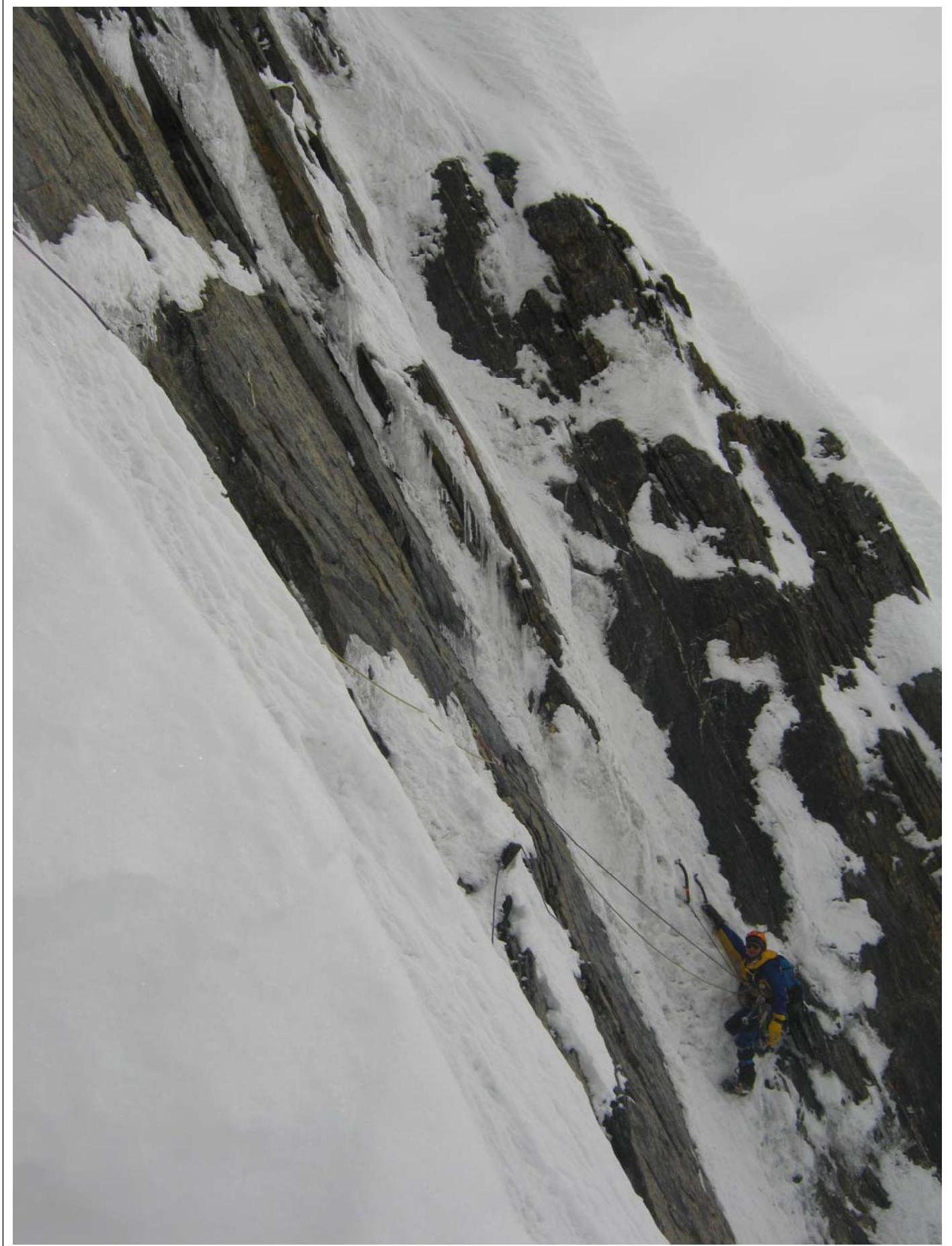
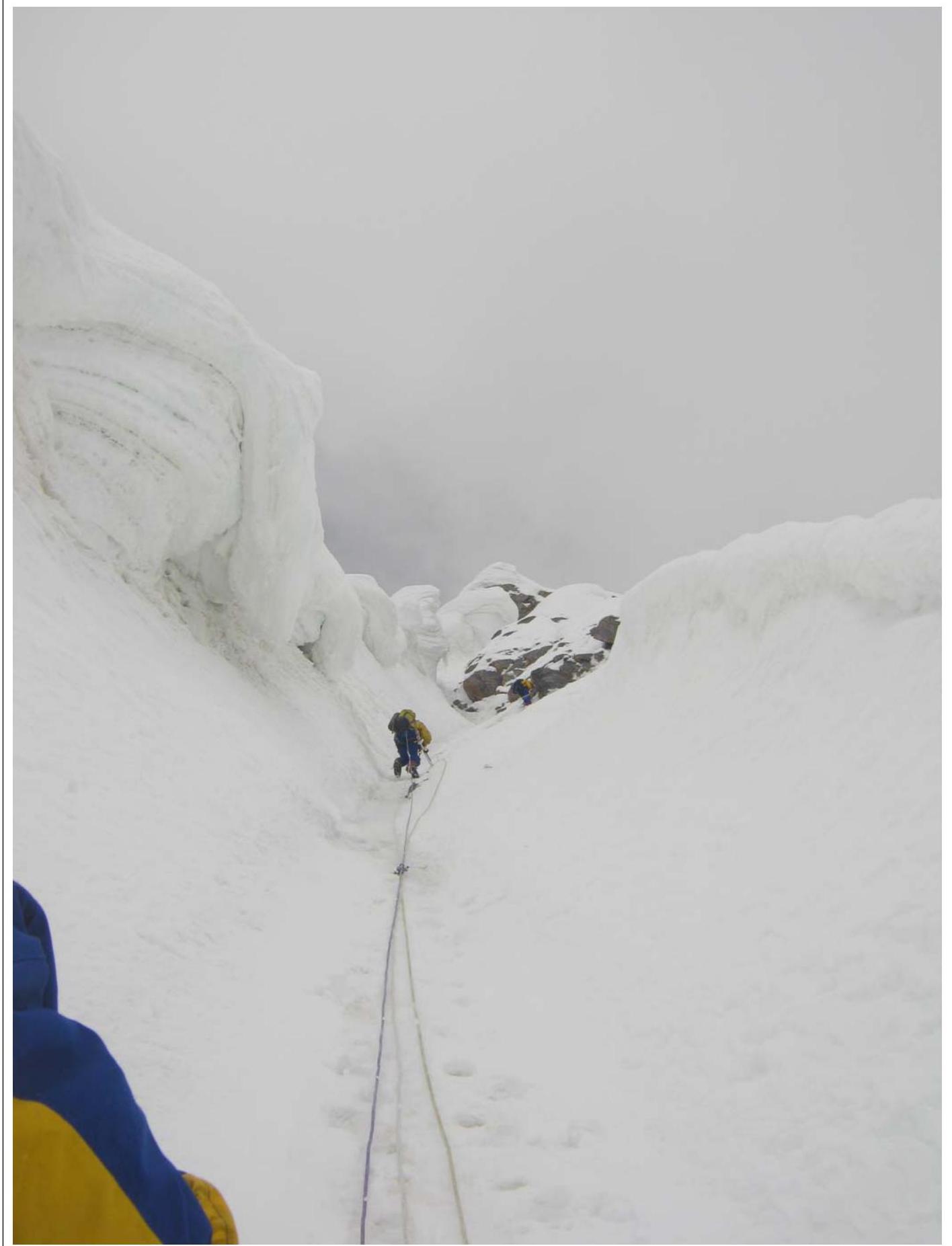
Technical photo of the route
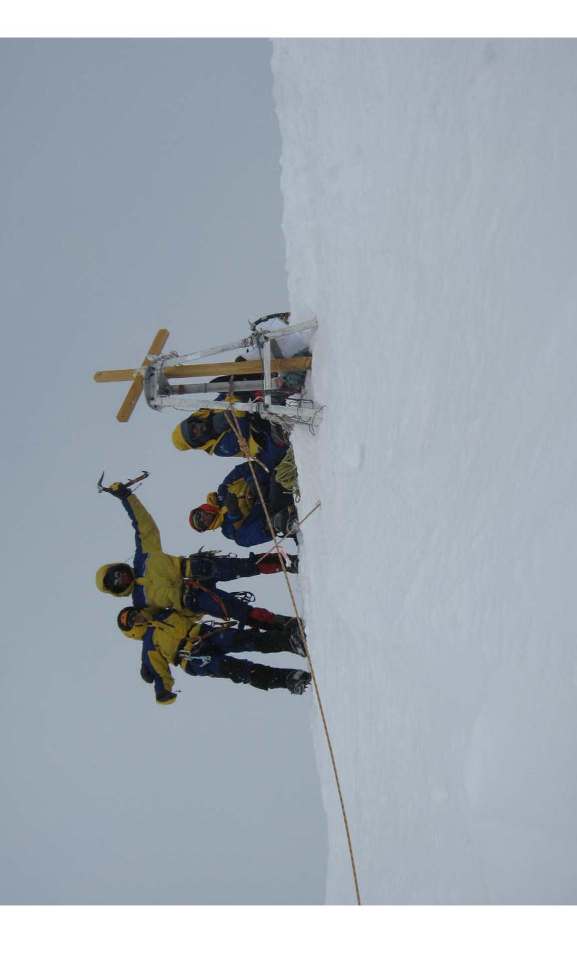
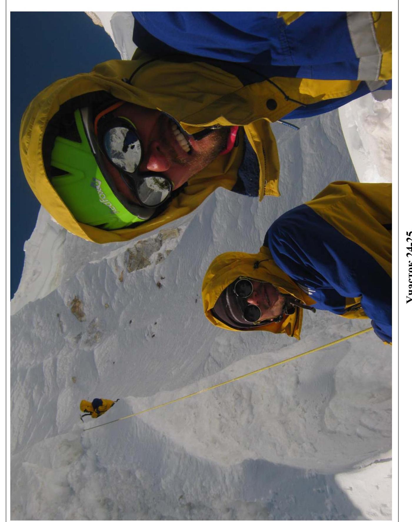
Team on the summit on August 19, and on August 20, 2013 at 7:00
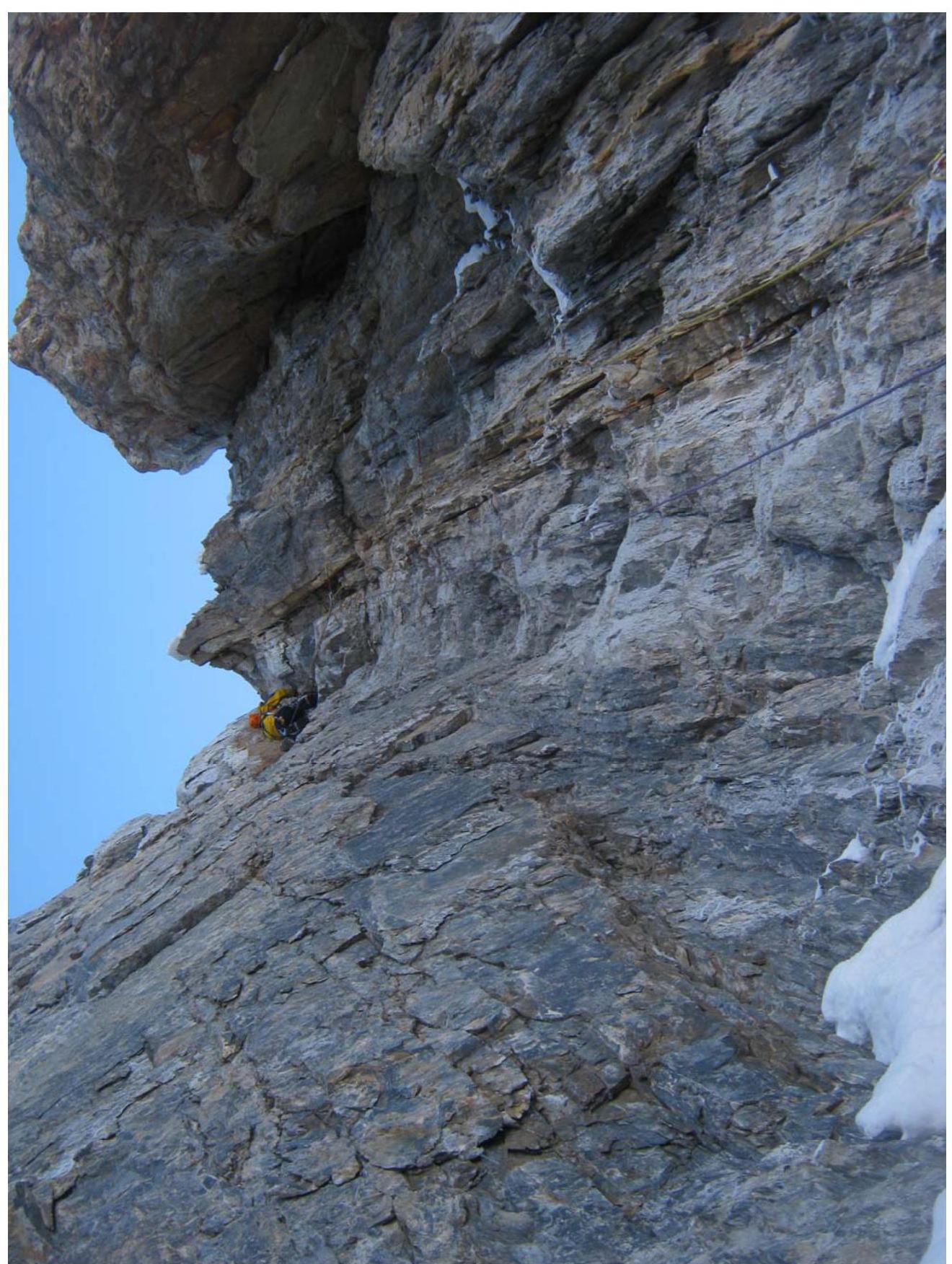
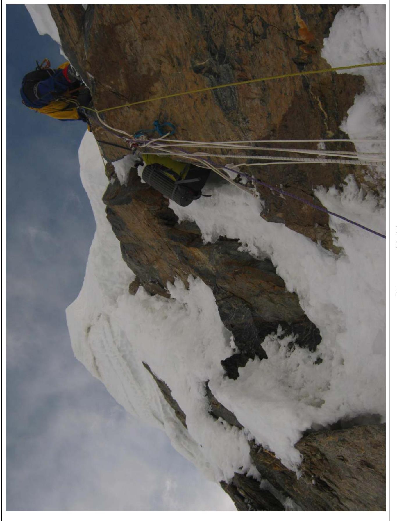
Section R1–R2. A. Zhigalov
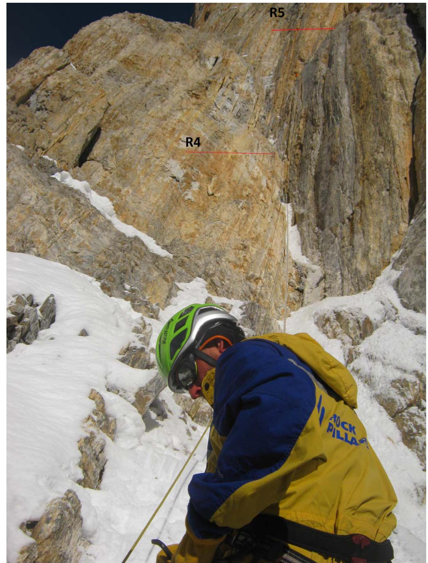
Sections R3–R4, R4–R5. Taken from section R2–R3
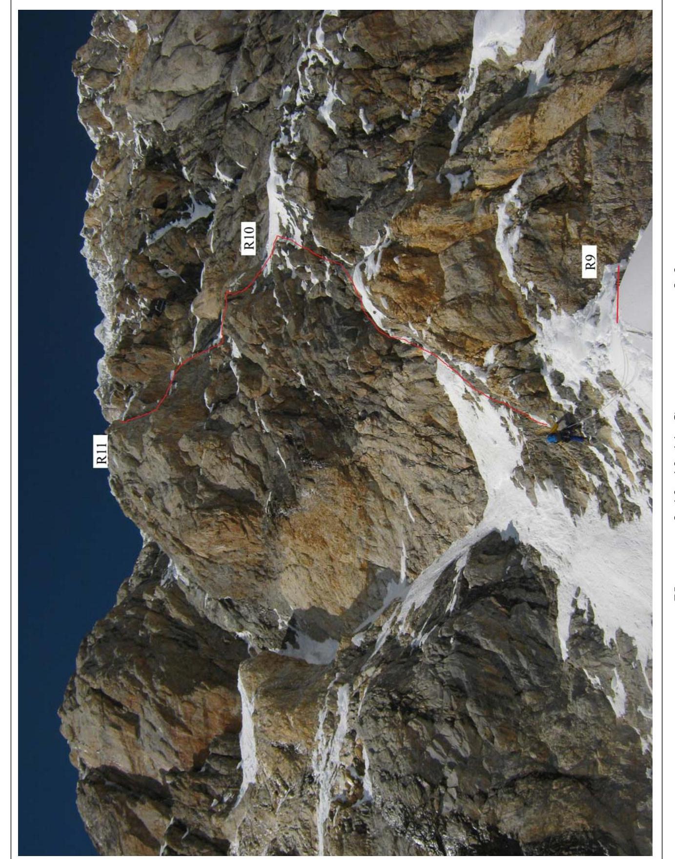
Sections R9–R10, R10–R11. Taken from section R8–R9
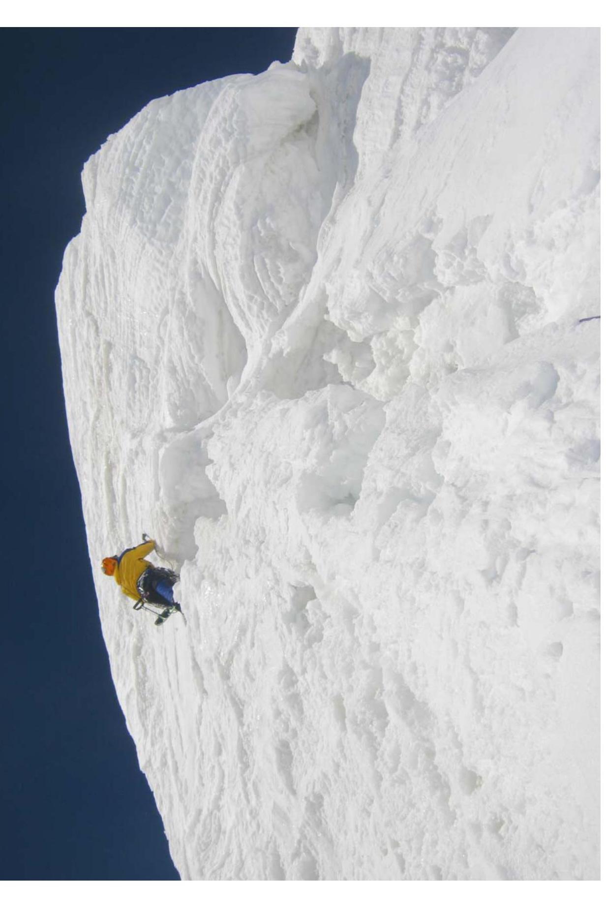
Section R13–R14. A. Pugovkin
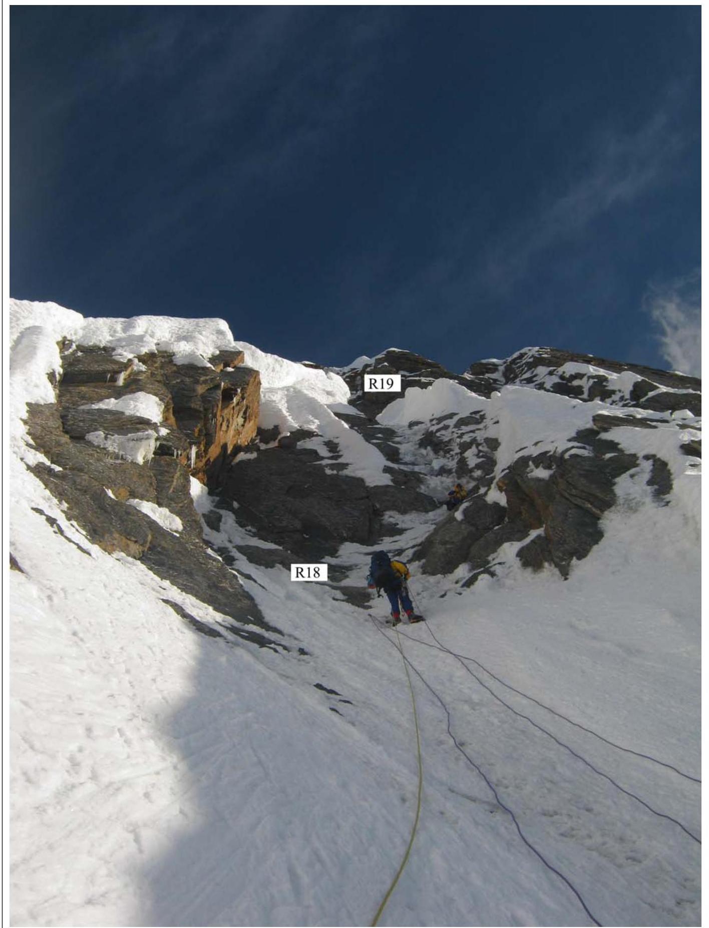
Sections R17–R18, R18–R19.
Section R19–R20. G. Kalita
Section R20–R21. A. Zhigalov
Section R21–R22.
Section R22–R23.
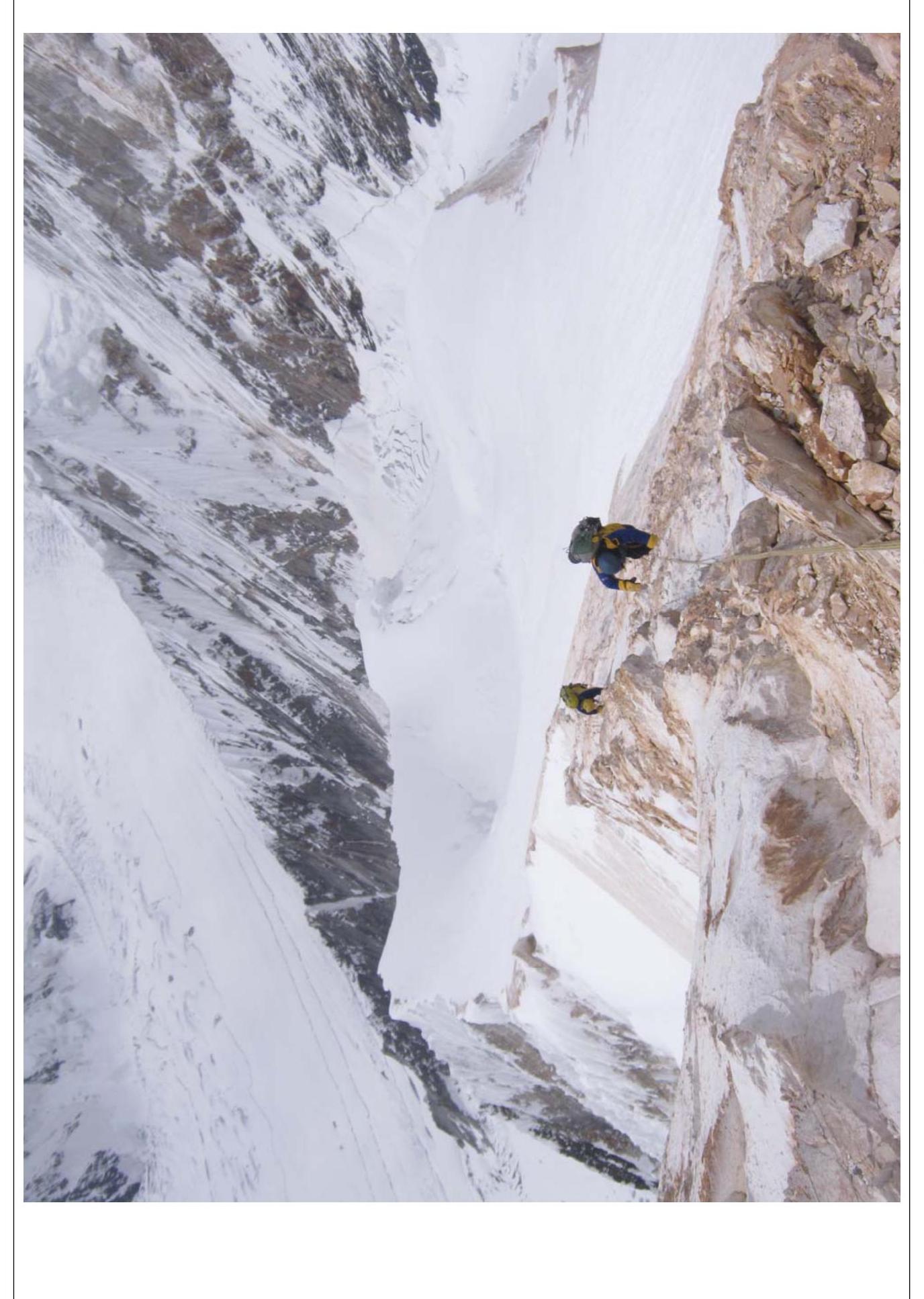
Section R24–R25. A. Zhigalov
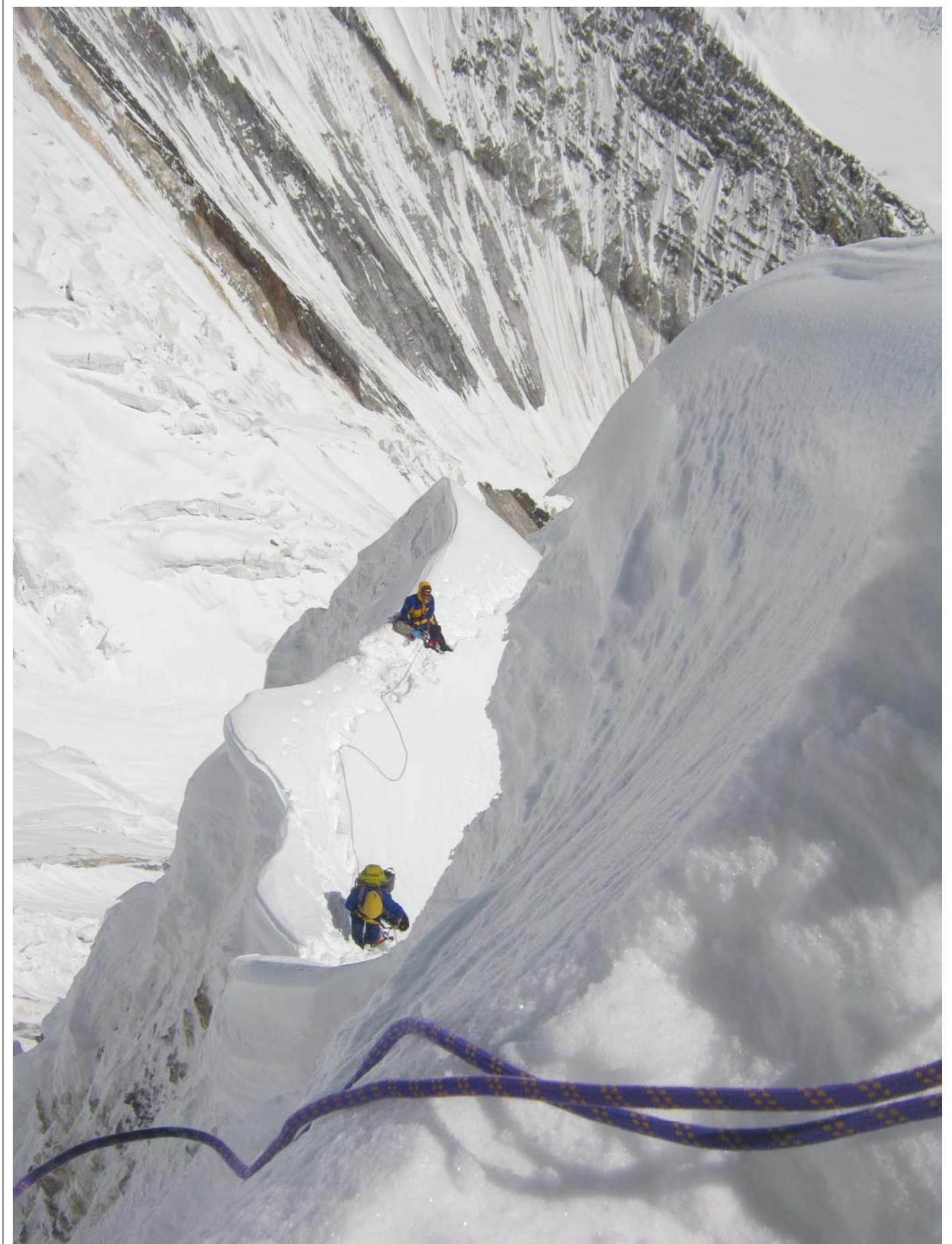
Section R24–R25.
Section R24–R25.
Section R25–R26.
Section R26–R27.
Dear Traveler!
To receive timely medical assistance, before undertaking anything, it is necessary to immediately contact the Service Center by phone indicated in the policy and inform the operator of the following information:
- surname, name of the Insured, in need of assistance
- policy number and its validity period
- nature of the required assistance
- location of the Insured and coordinates for feedback
Then, you must strictly follow the instructions of the operator. Russian-speaking operators work around the clock! Independent seeking of medical assistance may result in a refusal to compensate for expenses incurred!
Emergency phone numbers for free medical assistance in the following countries:
- Turkey: 0 800 51103 32 (toll-free); 0 242 310 28 48 (Antalya);
- Bulgaria: 056 841 603, 0 888 87 79 79;
- Egypt: 02 241 37 302;
- Spain: 900 502 740 (toll-free);
- Italy, Andorra: +34 91 387 46 17 (toll-free).
Single emergency phone number for free medical assistance in other countries:
- +380 44 239 88 20 (Kiev);
- (+7 495) 921 46 61 (Moscow).
Attention: each country and hotel has its own rules for dialing and international access codes, please clarify them before calling.
We wish you a pleasant trip! Dear Doctor! The Holder of the present Policy is covered by the International Travel Health Insurance Plan. Before providing him with medical help, please contact our 24-hour Alarm Center tel.: + 38 044 239 88 20 (Kiev), (+7 495) 921 46 61 (Moscow). Thank you!