
- Climbing class: High-altitude technical
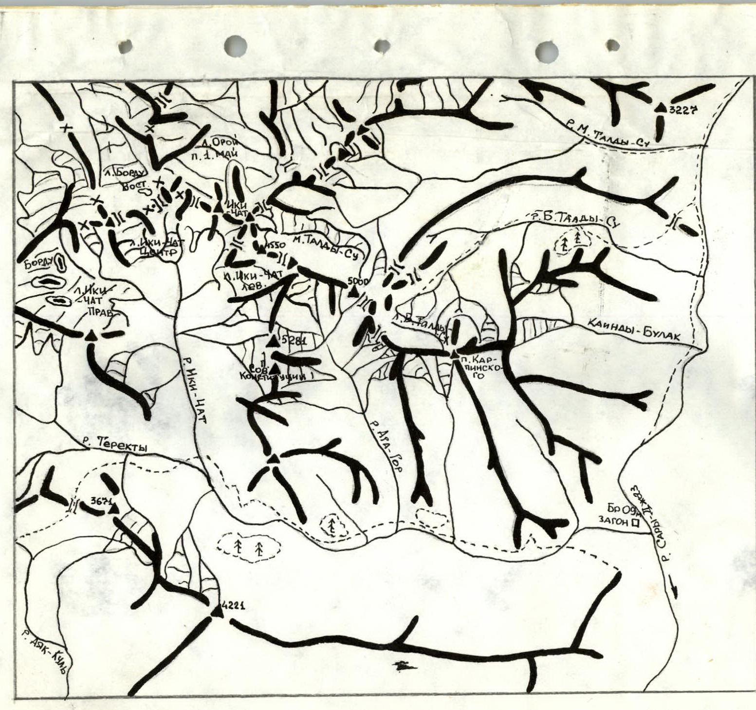
- Climbing area, ridge: Central Tien-Shan, Terekty river area.
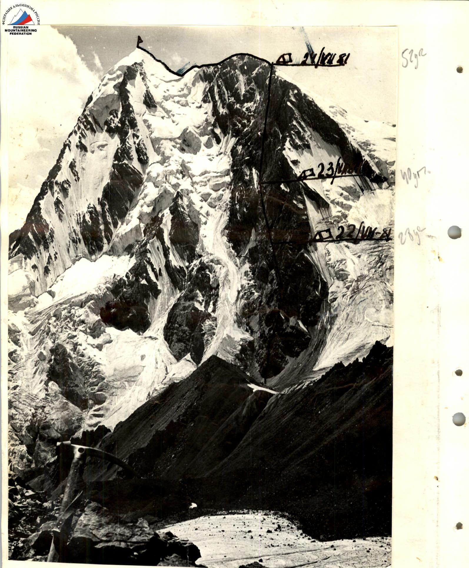
- Peak, its height, climbing route: peak Sovetskoy Konstitutsii 5250 m via the Eastern wall.
- Proposed difficulty category: 6B.
- Route characteristics: height difference 1320.
- Pitons driven: for belaying: 232. Placement elements: 126. Rock: 94 Ice: 12 Bolt: none For creating artificial holds: 78
- Number of nights and their characteristics: 2 lying down, 1 sitting.
- Number of travel hours: 46 hours.
- Surname, name, patronymic of the leader, participants and their qualifications:
- Kudashkin Yu.V. — Master of Sports, leader
- Popov F.E. — Master of Sports, participant
- Vakurin V.V. — Candidate for Master of Sports, participant
- Kuropatkin V.P. — Candidate for Master of Sports, participant
- Shchepak S.V. — Candidate for Master of Sports, participant.
- Team coach: Popov F.E.
- Date of departure and return: from July 21 to July 24, 1981.
 Team's route
| Date | Designation | Average steepness in degrees | Length in meters | Terrain character | Difficulty | Condition | Weather conditions | Rock | Ice | Placement elem. | Rock | Ice | Placement elem. | Time of departure and stop for bivouac, travel hours, overnight conditions |
|---|---|---|---|---|---|---|---|---|---|---|---|---|---|---|
| July 21, 1981 | 0–1 | 55° | 50 | ice | 4 | porous | satisfactory | 10 | Departure at 3:30 | |||||
| 1–2 | 50° | 30 | wall | 4 | rocks destroyed | satisfactory | Travel hours 14:00 | |||||||
| 2–3 | 45° | 15 | rocky ridge | 4 | rocks destroyed | satisfactory | Overnight lying down | |||||||
| 3–4 | 50° | 40 | wall | 4 | rocks destroyed | satisfactory | 5 | |||||||
| 4–5 | 80° | 10 | wall | 5 | rocks monolithic | satisfactory | 2 | 3 | ||||||
| 5–6 | 60° | 40 | wall | 5 | rocks destroyed | satisfactory | 2 | 2 | 4 | |||||
| 6–7 | 50–55° | 45 | wall | 4 | rocks destroyed | satisfactory | 4 | 1 | 2 | |||||
| 7–8 | 50° | 20 | traverse | 4 | rocks destroyed | satisfactory | 3 | |||||||
| 8–9 | 75° | 40 | chimney with a plug | 5 | rocks | satisfactory | 6 | 2 | ||||||
| 9–10 | 70° | 60 | bastion wall | 5 | rocks large-block | satisfactory | 2 | 6 | ||||||
| 10–11 | 80° | 40 | bastion wall | 6 | rocks monolithic | satisfactory | 4 | 3 | 5 | 6 | ||||
| 11–12 | 65° | 20 | bastion wall | 5 | rocks destroyed | satisfactory | 3 | 4 | ||||||
| 12–13 | 35° | 10 | ledge | 4 | rocks destroyed | satisfactory | 1 | 2 | ||||||
| 13–14 | 50° | 60 | wall | 5 | rocks destroyed | satisfactory | 2 | 3 | ||||||
| 14–15 | 45° | 20 | wall | 4 | rocks destroyed | satisfactory | 1 | 3 | ||||||
| 15–16 | 70° | 20 | wall traverse | 4 | rocks destroyed | satisfactory | 1 | 3 | ||||||
| 16–17 | 90° | 30 | giant chimney | 6 | rocks monolithic | satisfactory | 3 | 5 | 1 | |||||
| 17–18 | 95° | 20 | overhanging chimney | 6 | rocks monolithic | satisfactory | 1 | 4 | 2 | 4 | ||||
| 18–19 | 80° | 20 | wall | 5 | monolithic | satisfactory | 2 | |||||||
| 19–20 | 65° | 40 | wall | 5 | rocks destroyed | satisfactory | 2 | 4 | ||||||
| 20–21 | 75° | 20 | wall | 5 | rocks | wet fine snow | 1 | 3 | ||||||
| 21–22 | 80° | 40 | wall | 5 | rocks | satisfactory | 4 | 1 | ||||||
| 22–23 | 75° | 40 | wall | 5 | rocks | satisfactory | 2 | 2 | ||||||
| 23–24 | 95° | 5 | cornice | 6 | rocks destroyed | satisfactory | 1 | 2 | 1 | 3 | ||||
| 24–25 | 60° | 60 | wall | 5 | rocks destroyed | satisfactory | 4 | 3 | ||||||
| 25–26 | 100° | 2 | cornice | 5 | rocks | satisfactory | 2 | |||||||
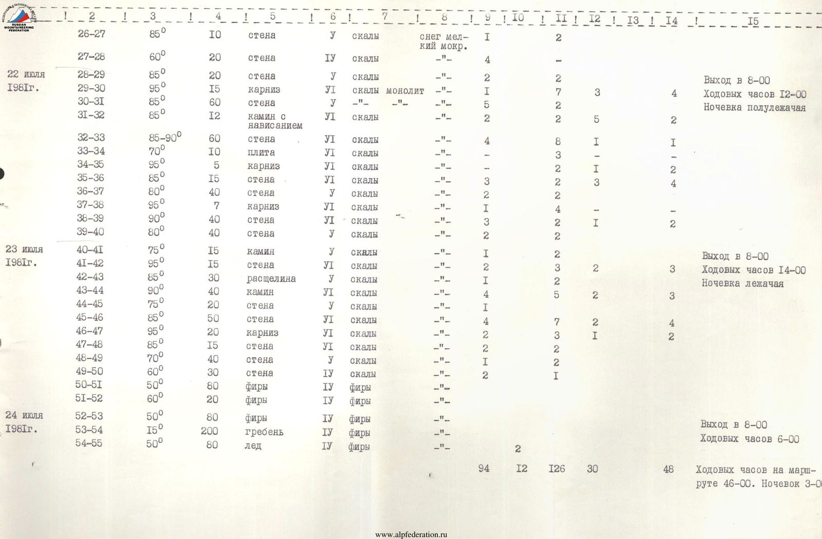
| July 22, 1981 | 26–27 | 85° | 10 | wall | 5 | rocks | wet fine snow | 1 | 2 | Departure at 8:00 | ||||
| 27–28 | 60° | 20 | wall | 4 | rocks | satisfactory | 4 | |||||||
| 28–29 | 85° | 20 | wall | 5 | rocks | satisfactory | 2 | 2 | ||||||
| 29–30 | 95° | 15 | cornice | 6 | rocks monolithic | satisfactory | 1 | 7 | 3 | 4 | Travel hours 12:00 | |||
| 30–31 | 85° | 60 | wall | 5 | rocks monolithic | satisfactory | 5 | 2 | Overnight semi-reclined | |||||
| 31–32 | 85° | 12 | chimney with overhang | 6 | rocks | satisfactory | 2 | 2 | 5 | 2 | ||||
| 32–33 | 85–90° | 60 | wall | 6 | rocks | satisfactory | 4 | 8 | 1 | 1 | ||||
| 33–34 | 70° | 10 | slab | 6 | rocks | satisfactory | 3 | |||||||
| 34–35 | 95° | 5 | cornice | 6 | rocks | satisfactory | 2 | 1 | 2 | |||||
| 35–36 | 85° | 15 | wall | 6 | rocks | satisfactory | 3 | 2 | 3 | 4 | ||||
| 36–37 | 80° | 40 | wall | 5 | rocks | satisfactory | 2 | 2 | ||||||
| 37–38 | 95° | 7 | cornice | 6 | rocks | satisfactory | 1 | 4 | ||||||
| 38–39 | 90° | 40 | wall | 6 | rocks | satisfactory | 3 | 2 | 1 | 2 | ||||
| 39–40 | 80° | 40 | wall | 5 | rocks | satisfactory | 2 | 2 | ||||||
| July 23, 1981 | 40–41 | 75° | 15 | chimney | 5 | rocks | satisfactory | 1 | 2 | Departure at 8:00 | ||||
| 41–42 | 95° | 15 | wall | 6 | rocks | satisfactory | 2 | 3 | 2 | 3 | Travel hours 14:00 | |||
| 42–43 | 85° | 30 | crack | 5 | rocks | satisfactory | 1 | 2 | Overnight lying down | |||||
| 43–44 | 90° | 40 | chimney | 6 | rocks | satisfactory | 4 | 5 | 2 | 3 | ||||
| 44–45 | 75° | 20 | wall | 5 | rocks | satisfactory | 1 | |||||||
| 45–46 | 85° | 50 | wall | 6 | rocks | satisfactory | 4 | 7 | 2 | 4 | ||||
| 46–47 | 95° | 20 | cornice | 6 | rocks | satisfactory | 2 | 3 | 1 | 2 | ||||
| 47–48 | 85° | 15 | wall | 6 | rocks | satisfactory | 2 | 2 | ||||||
| 48–49 | 70° | 40 | wall | 5 | rocks | satisfactory | 1 | 2 | ||||||
| 49–50 | 60° | 30 | wall | 4 | rocks | satisfactory | 2 | 1 | ||||||
| 50–51 | 50° | 80 | firn | 4 | firn | satisfactory | ||||||||
| 51–52 | 60° | 20 | firn | 4 | firn | satisfactory | ||||||||
| July 24, 1981 | 52–53 | 50° | 80 | firn | 4 | firn | satisfactory | Departure at 8:00 | ||||||
| 53–54 | 15° | 200 | ridge | 4 | firn | satisfactory | Travel hours 6:00 | |||||||
| 54–55 | 50° | 80 | ice | 4 | firn | satisfactory |
94 12 126 30 48 Travel hours on the route 46:00. Overnights 3:00.
850 m along the slope, wet fine snow
Brief explanation of the table
Section 0–1 — ice-firn slope, porous, passed in lumps.
1–2 — rocks of medium complexity, very destroyed, passed without pitons.
2–3 — rocky ridge, steep, rocks destroyed, possible rockfall.
3–7 — wall with small holds, not very steep. Belaying mainly with pitons. Rocks destroyed, rockfall possible in the lower part. Very difficult to organize reliable belaying.
7–13 — Section is a granite belt, very monolithic. Placement elements almost not used. In the middle part, the belt transitions into a bastion "small". It is bypassed on the left along a very complex wall. Exits onto a scree ledge.
13–16 — rocky wall, rocks destroyed, climbing not complicated, but very dangerous, many loose rocks.
16–19 — giant chimney. In the lower part — monolithic. At the exit, rocks destroyed. Passed using ladders, placement elements, and rock of the step.
19–28 — schist belt. Very destroyed. Belaying unreliable.
28–31 — rocky wall. Climbing very complex. Monolithic. In the upper part, deviation to the right. Cracks not large. Mostly petal-shaped pitons and "Hexes" used.
31–34 — chimney, overhanging in the upper part.
34–37 — rocky wall, very slippery. Climbing complicated by constantly falling snow.
37–38 — cornice — exit to the "belly". Everything is slippery.
38–39 — bypass on the right of the "belly". Rocks overhanging. Climbing very complex. This is the 1st piton section of the route.
Section 39–40 — rocky wall. Monolithic.
40–47 — Crack. In the lower part narrow. In the upper part transitions into a chimney, which leads to a giant cornice. Climbing very complex.
47–48 — Giant cornice. 2nd piton section. Very complex. Passed using rope ladders.
48–50 — rocky wall. Destruction. Exit to firn.
50–52 — firn slope. Ice in some places.
52–53 — ridge, ice.
53–54 — rocky ridge, not steep.
54–55 — ice slope.