
Climbing passport.
- Climbing category — technical.
- Climbing area — Sayany.
- Summit, its height, ascent route — unnamed, 2300 m, South-Eastern ridge.
- Proposed difficulty category — 2B.
- Route characteristics: height difference — 500 m, average steepness — 35°.
- Pitons driven for belay: rock — 5, ice — , bolt — .
- Number of travel hours — 5.
- Number of overnight stays — .
- Surname, initials of the leader, participants and their qualification: KURMACHEV Yu.F. — leader, 1st sports category. PANKOV A.F. — participant, Candidate for Master of Sports. SEREDA V.A. — participant, 1st sports category. CHEpalov V.A. — participant, 1st sports category.
- Team coach — .
- Date of departure and return — May 8, 1976.
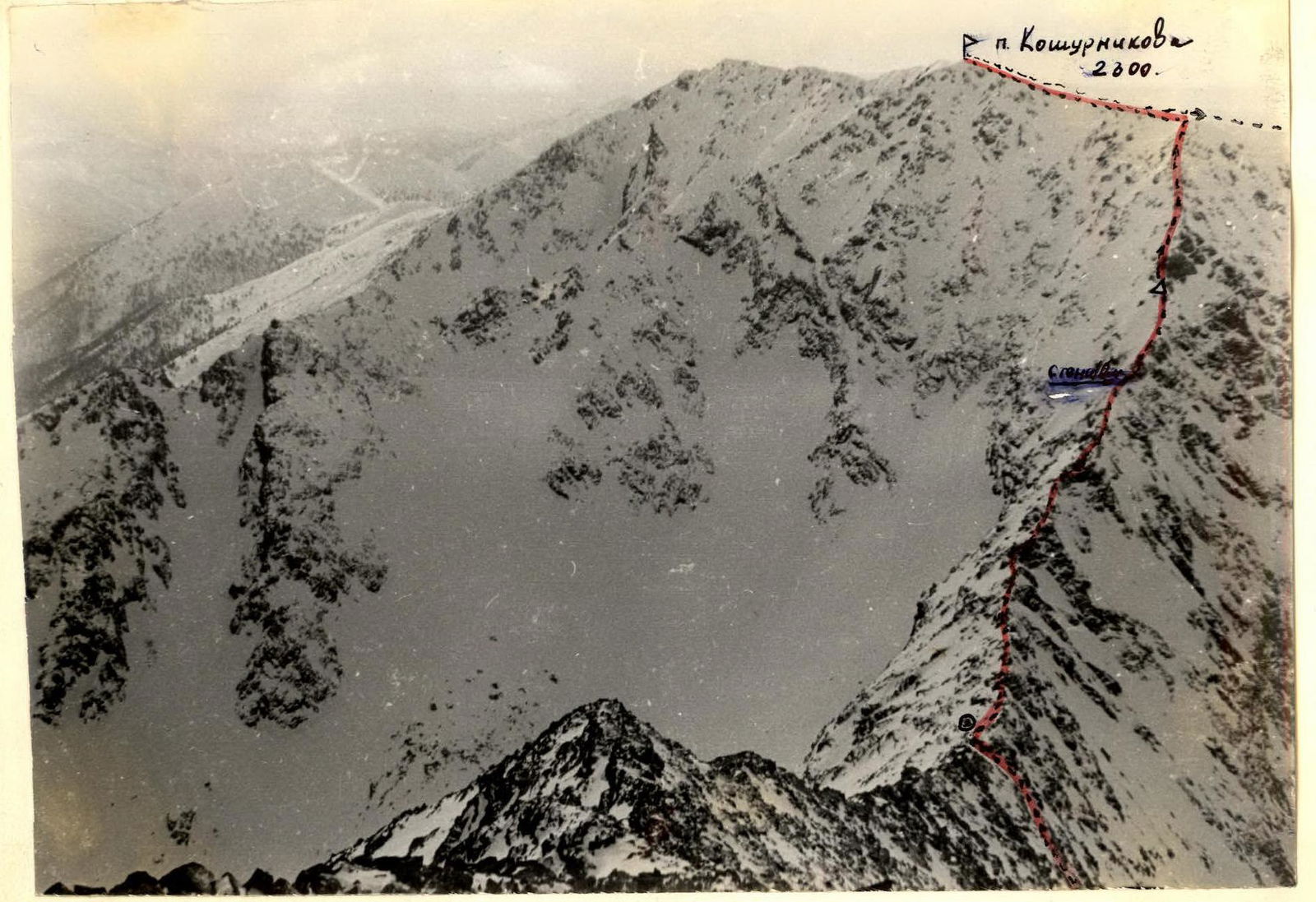
Pik Koshurnikova (2300)
South-Eastern ridge from the saddle between Mt. Maly Borus and Pik Koshurnikova, 2B category of difficulty, first ascent. Climbers: Kurmachev Yu.F., Pankov A.F., Sereda V.A., Chepalov V.A. May 8, 1976.
Pik Koshurnikova is located in the north-western direction from the summit of Maly Borus in the central part of the Borus ridge, stretching north of the Main ridge of the Western Sayany. The base camp of climbers is set up at the forest boundary on the shore of a small lake in the Left circus under the plateau, separating the circuses of Borus and Pik Koshurnikova at an altitude of 1300 m (see diagram) six hours walk from the settlement of hydrobuilders of the Sayano-Shushenskaya HPP Cheremushki.
From the base camp across the plateau and the western slope of Mt. Maly Borus, exit via scree to the left (orographically) of the saddle between Maly Borus and Pik Koshurnikova (2 hours). Connect. The overhanging rock wall (10 m, 93°) is bypassed on the left via ledges (section R1). Further movement is simultaneous, belay via protrusions (210 m). The second rock wall (6 m, 90°) is climbed in the right part with piton belay, no bypass (section R2). Further, with alternating belay via ice axe, sections of the ridge with snow cornices are overcome (section R3, 30 m). Section R3 ends with a gap in the ridge. Rappelling 7 m (R4). Further, with alternating belay along the ridge to the base of the vertical wall (section R5, 30 m). The wall (10 m, 70°) with protruding slabs is overcome with piton belay (section R6). Then the ridge widens, movement across broken rocks is simultaneous (60 m). A large inclined slab (30°, 10 m) is climbed in the center with the organization of a belay (section R8). Behind the slab — a control cairn. Further snow-covered broken rocks (35°, 300 m) lead to the pre-summit gentle eastern ridge. To the summit 250 m.
Descent along the eastern ridge (3 hours).
Approximate time breakdown for the route:
- section R1 — 30 minutes
- section R2 — 30 minutes
- section R3 — 1 hour
- section R4, R3 — 1 hour
- section R5, R6, summit — 1 hour
- descent — 3 hours
Equipment for a group of 6 people:
- personal equipment of an alpine climber of stage 2 training
- main rope — 3 × 40 m
- rock pitons — 6 pcs.
- carabiners total — 4 pcs.
- hammer — 2 pcs.
- auxiliary cord — 3 m