Ascent Passport
- Ascent class: technically challenging.
- Ascent area: Eastern Sayan, Tunka Alps, Zuun-Khandagai gorge.
- Dinosaur Peak: shoulder of the southwest ridge.
- Proposed difficulty category: 2B.
- Route characteristics: elevation gain — 700 m, average steepness: 45°, length of sections: R0–R1 — 2.5 km. R1–R2 — 500 m. R2–R3 — 90 m. R3–R4 — 450 m. Total: — 3550 m.
- Number of anchors driven for belay: rock anchors — 5 pcs.
- Number of travel hours: 10 hours from camp to camp.
- Overnight stay: in the base camp.
- Leader: Trubnikov V.I., MS, senior instructor. Nikonov V.P. 1st category, Potapov V.G. 1st category, Udovenko V.A. CMS, Enaev A.A. CMS, Firsov V.G. CMS.
- Team coach: Trubnikov V.I.
- Date of departure on the route: May 3, 1977.
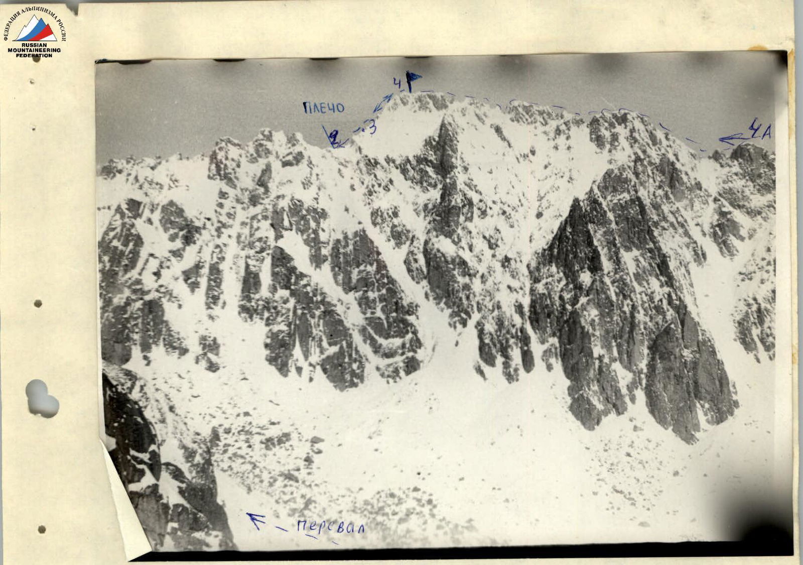 View of Dinosaur Peak from Zuun-Khandagai gorge
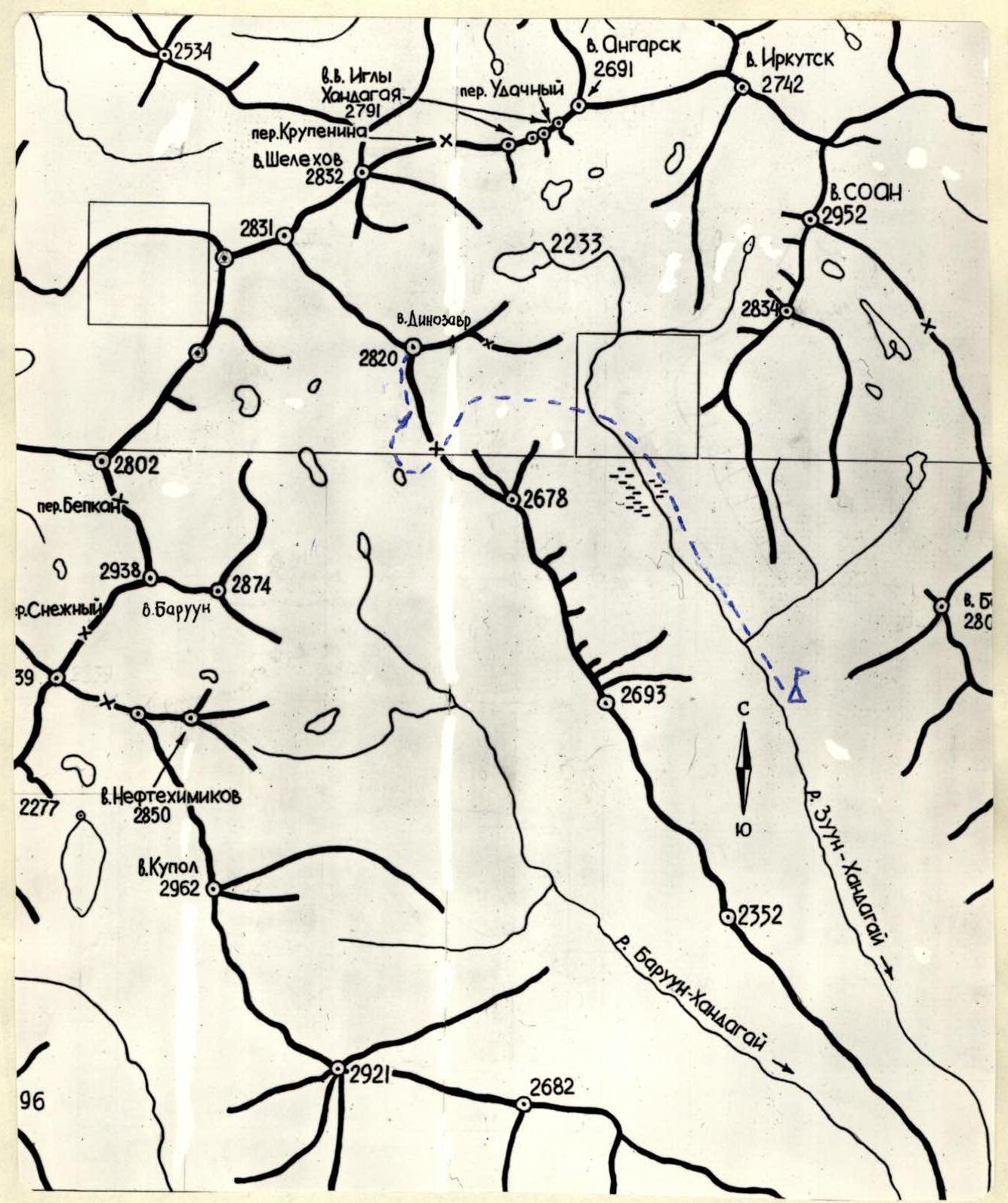
Map Scheme
Geographic and Climbing Characteristics
Dinosaur Peak is located in the Zuun-Khandagai gorge on the southern side of the Tunka Alps. The forest boundary ends 2 km from the peak. There is a classified route to this peak via the eastern ridge, category 4A. The approach to the start of the route goes through Dinosaur Pass, category 1B. The route passes from the windward side of the peak, so it is always heavily snow-covered. The route has good passability. It is passable in any weather. A good landmark for entering the couloir is a large gendarme with a double peak, standing higher up the couloir to the right of the path not far from the bottom.
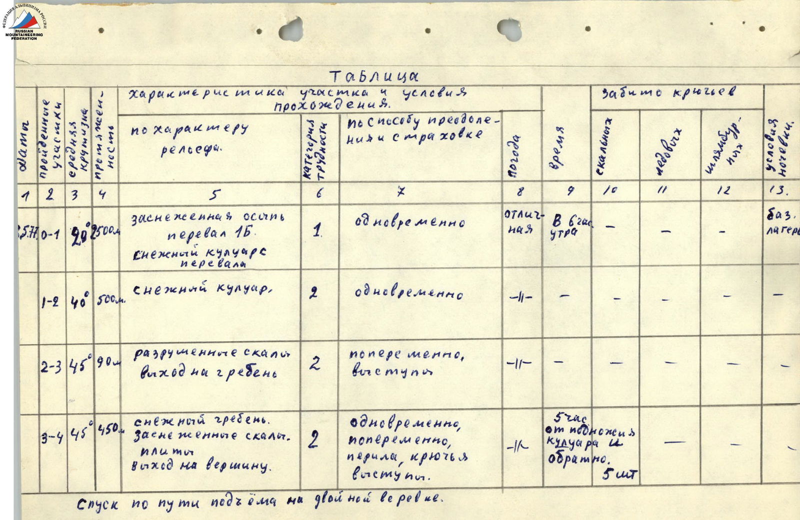
Table
| Sections traversed | Average steepness | Length | Characteristics by relief type | Difficulty category | Conditions for overcoming and belaying | Weather | Time | Rock anchors | Ice anchors | Drill anchors | Overnight stay conditions |
|---|---|---|---|---|---|---|---|---|---|---|---|
| R0–R1 | 2.5 km | Snow-covered scree, pass 1B category. Snow couloir from the pass | 1 | Simultaneous | Excellent | At 7:00 am | – | – | – | Base camp | |
| R1–R2 | 40° | 500 m | Snow couloir | 2 | Simultaneous | – | – | – | – | – | – |
| R2–R3 | 45° | 90 m | Destroyed rocks, exit to the ridge | 2 | Alternating, outcrops | – | – | – | – | – | – |
| R3–R4 | 45° | 450 m | Snow ridge, snow-covered rocks, slabs, exit to the summit | 2 | Simultaneous, alternating, rope barriers, anchors, outcrops | – | 5 hours from the foot of the couloir and back | 5 pcs. | – | – | – |
Descent via the ascent route on a double rope.
Route Description
Section R0–R1
We leave the base camp in the Zuun-Khandagai gorge at 7:00 am. We ascend to Dinosaur Pass along a ready-made trail in 2.5 hours. The height loss from the pass to the Barun-Khandagai gorge is about 100 meters. We go along the descent path to the right along the slope on snow-covered medium scree for 40 minutes to the last large couloir. (See panorama).
Section R1–R2
The couloir is filled with snow, avalanche tracks are visible. The crust holds well. The steepness of the couloir reaches 40° in some places. We move simultaneously, changing the leader. The length of the couloir is 500 m. We exit to the shoulder of the ridge. (See panorama).
Section R2–R3
From the shoulder, we move to the left. We pass the rocks of the first ascent of the ridge on the left along the path. There are many loose rocks. The movement is simultaneous and alternating. Belay via outcrops. The length is 2 ropes. Exit to the ridge. (Photo: general view, 1–2).
Section R3–R4
Then we move along the ridge. There is a lot of snow, rocks have to be cleared for a long time. The rocks are monolithic slabs. We organize two rope barriers on this section (40 m each). We drive 5 anchors. The length is 450 m. (Photo: 3, 4, 5, 6).
We reach the summit. We retrieve the note left by the first ascenders in October 1972 via the eastern ridge, category 4A. Descent via the ascent route on a double rope with rope pull. It took 5 hours from the foot of the couloir to the summit and back.
Recommendations
- Departure no later than 5:00 am.
- The couloir is avalanche-prone in warm times of the day.
- Have a set of anchors from 4 to 20 mm, 5 pcs.
- Have 5 m of expendable cord.
The group believes that the route corresponds to category 2B in winter conditions, because despite the insufficient length, it has a diverse set of technical difficulties and is quite passable for a training group.
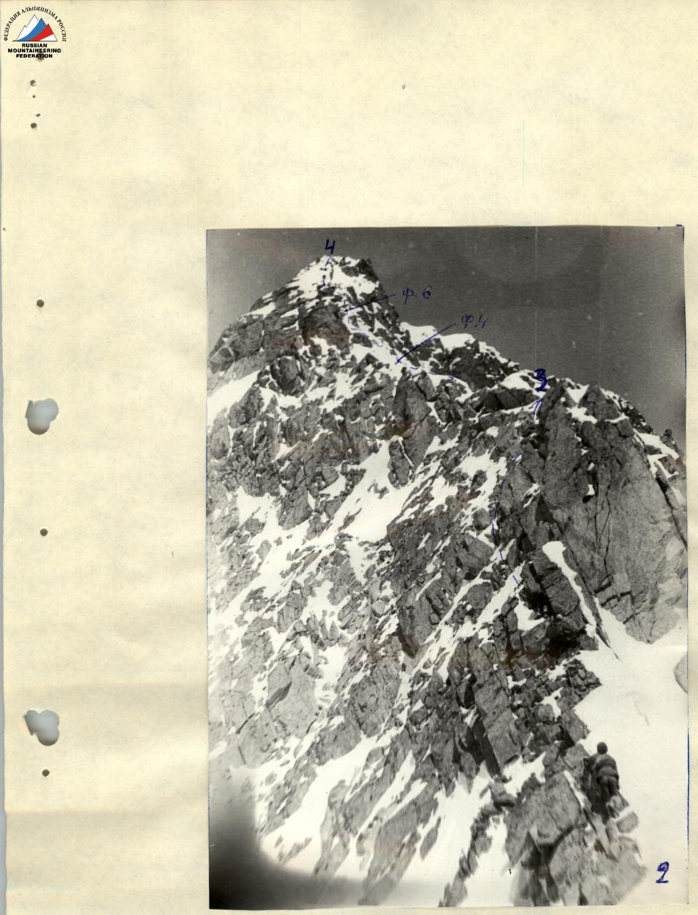 General view of the route