
53a
USSR Alpine Championship
High-Altitude Technical Climbing Category
Report
on the first ascent of Peak 6113 m via the right part of the north face by the Ukrainian "Burevestnik" Sports Club team
Team leader: I.V. Bozhko Coach: A.M. Bychek

1985, Ukrainian Council of the "Burevestnik" Sports Club
252000, Kiev, Vorovsky St., 30-g, tel. 26-37-16
Team leader: Bozhko Igor Vasilievich, 252211, Kiev, Priozerny St., 8, apt. 128, tel. 446-40-65 (work)
Coach: Bychek Alexander Mikhailovich, 252158, Kiev, Koltsov Blvd., 11, apt. 30, tel. 485-36-06
The heights mentioned in the report were determined using an altimeter.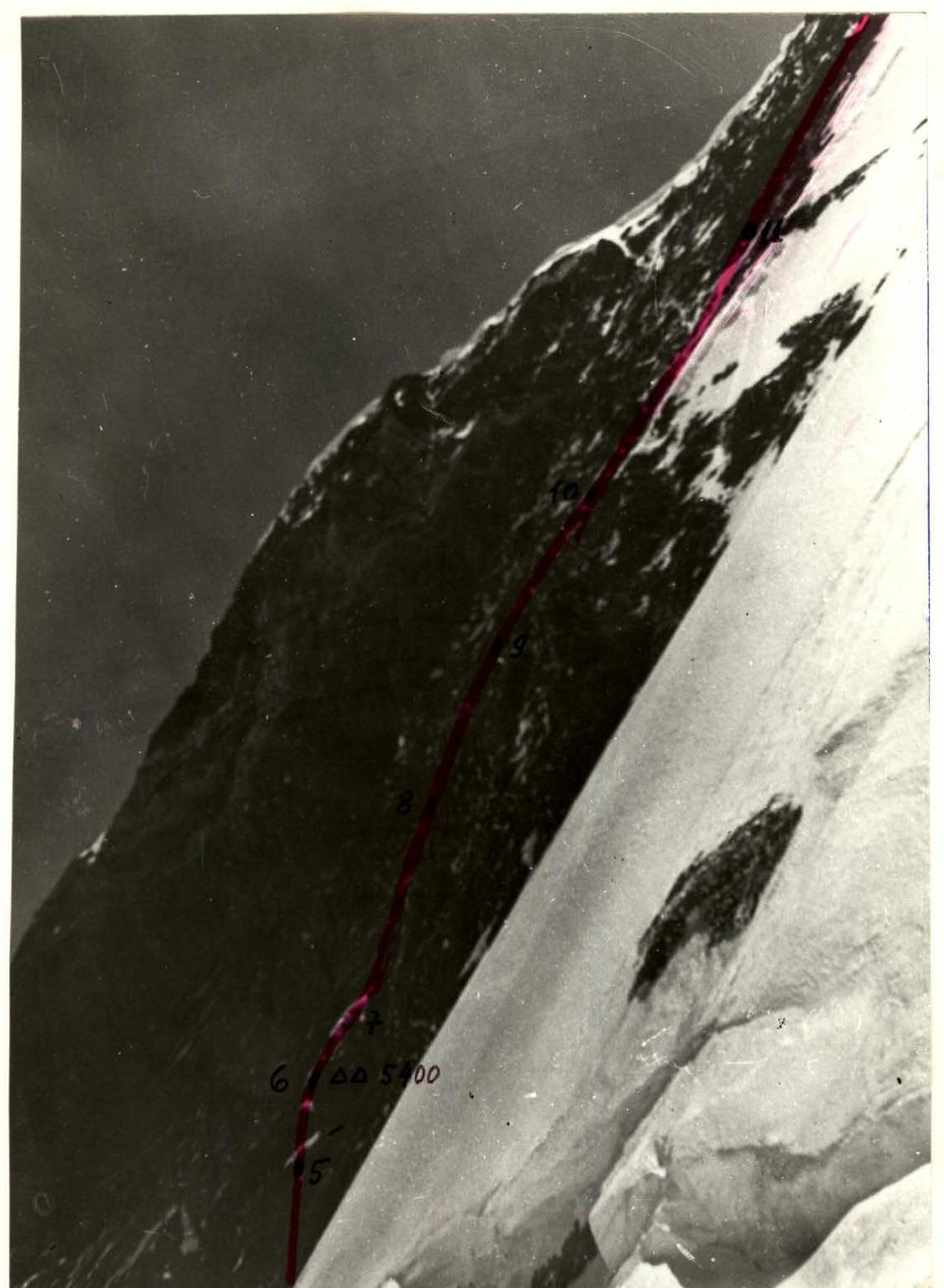
Photo 2. Right wall profile. Taken on August 1, 1985, at 13:00 with a "Smena" camera, T-43 4/40 lens. Distance to the object — 800 m, shooting point #2 on the area map, elevation of the shooting point — 5100 m.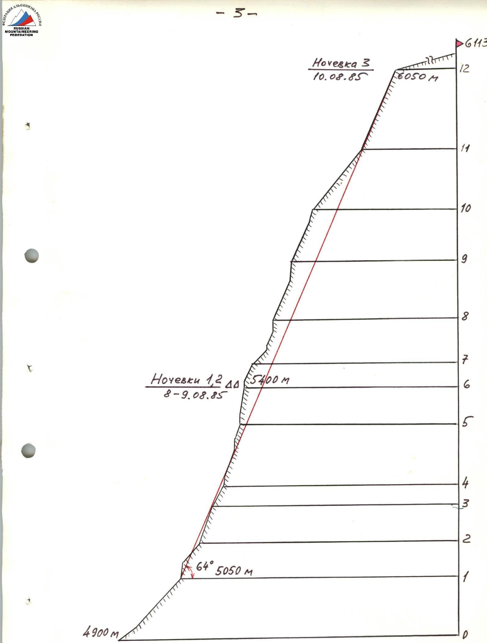
Route profile M 1:5000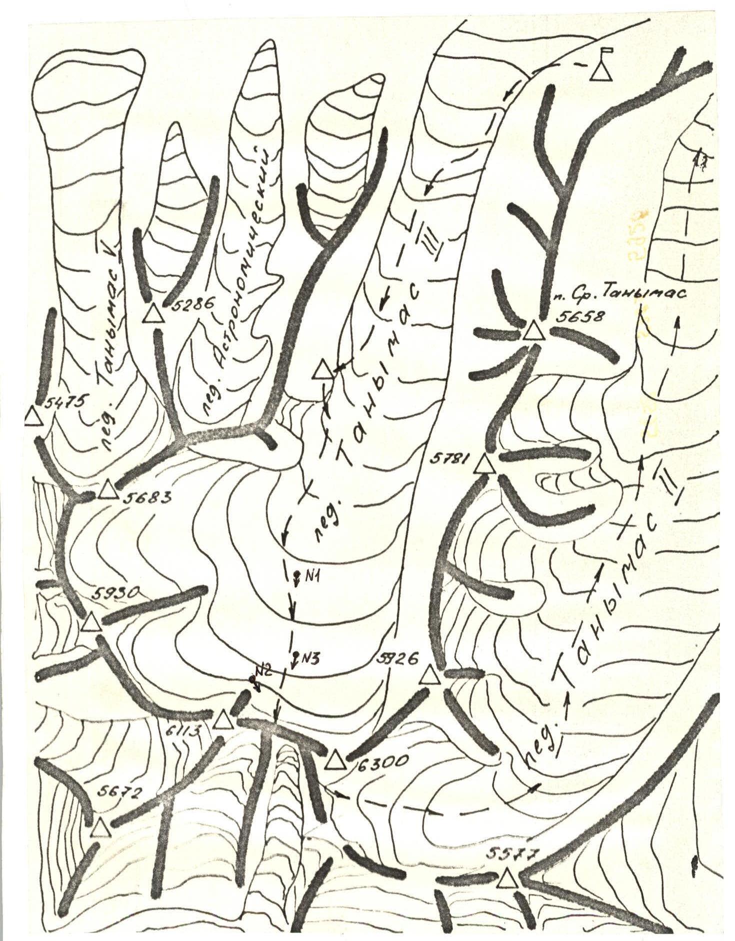
Area map M 1:50000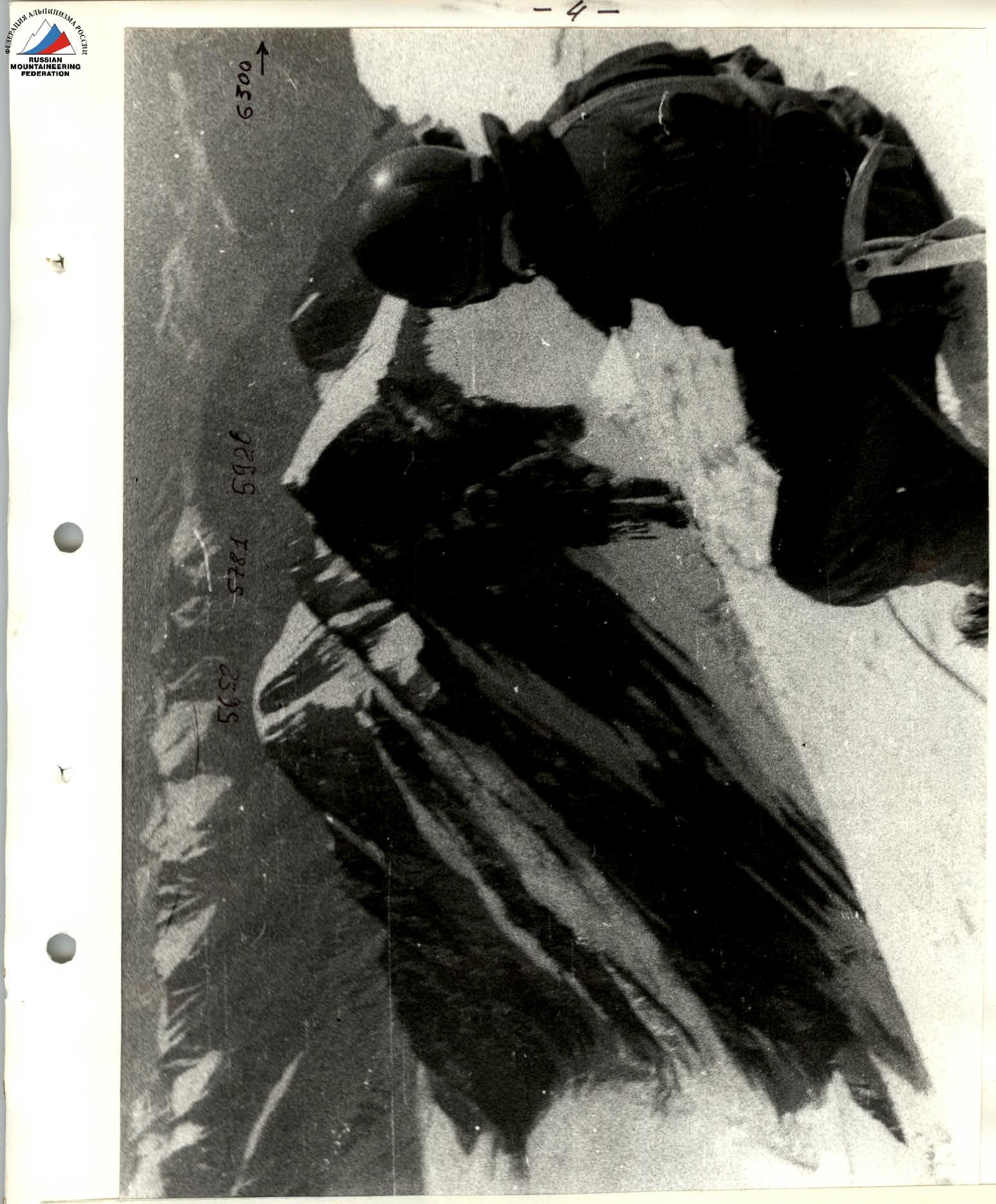
Photo 3. Panoramic photo of the area. Taken on August 2, 1985, at 10:00 with a "Smena" camera, T-43 4/40 lens, from the summit of 6113.
Brief Overview of the Climbing Area
Peak 6113 m is located in the Yazgulem Range. The northern slopes of the peak descend to the Tanymas-3 glacier, and the southern slope is bounded by the Vitkovsky glacier. The first topographic expeditions (1928–1930) reached the area from the Tanymas River valley. One can access the area from the Tanymas-3 glacier via the Tanymas Lap to the powerful Fedchenko glacier (4 hours walk). The base camp was set up by the Ukrainian Sports Committee team on a suitable helicopter landing site, 150 m above the end of the Tanymas-3 glacier. It takes about 3 hours to walk from the base camp to the observation camp along the Tanymas-3 glacier. It takes 1.5 hours to reach the start of the route from the observation camp. The area around the base camp (4250 m) is constantly windy. During the expedition (July 28 – August 12), the weather was unstable. Daytime temperature was 15–20 °C, nighttime temperature was −3–6 °C.
Pre-Climb Preparation
The team conducted regular physical and technical training sessions before heading to the mountains. In late April, a ten-day training camp was held in Crimea to practice rock climbing and pass physical fitness standards. Immediately before the climb, all team members participated in a 30-day training camp in the Fann Mountains (near the Alauddin Lakes), where they completed several climbs:
- Category 5B and 6 difficulty.
The team received initial information about the peak from I.G. Dorofeev, a participant in the first topographic expeditions (1928–1930). The team observed the route from the camp on the Tanymas-3 glacier (about 2 km from the start of the route) for several days before beginning the ascent.
As a result of the observations, the team finalized the route. The route is located on the right part of the north face, follows one of the counterforts, and is logical and safe. The lower part of the wall was the most challenging, being very steep, and was planned to be ascended using double ropes and, if necessary, artificial climbing techniques.
Climbing Schedule

Tactical Actions of the Team
The team departed from the base camp on August 6, 1985, at 14:00 to approach the route. By 18:30, the group reached the observation camp, located on the left moraine of the Tanymas-3 glacier, about 1.5 hours walk from the start of the route.
On August 7, at 9:00, the pair Slyusar — Cherevko approached the route and began processing the snow-ice slope with two bergschrunds. They fixed 6 ropes and returned to the observation camp by 15:00.
On August 8, at 8:30, the team began moving along the fixed ropes. The previous night's snowfall of 10 cm significantly complicated the movement on the rocks. The first pair, Bozhko — Khalik, worked ahead. The rocks were steep, heavily snow-covered, and crumbling, with challenging 80–90° walls up to 15–20 m high. The protection was mostly hook protection. The rest of the group followed on the fixed ropes. They spent the night under a small, safe, but uncomfortable cornice in a semi-sitting position, leaving a control cairn.
On August 9, it snowed throughout the night and most of the day, with fog. The pair Slyusar — Utochkin processed 4 ropes above the bivouac. They spent the night in the same location.
On August 10, the group began moving at 7:00. Slyusar, Cherevko, and Utochkin worked ahead in turns. The nature of the wall remained the same: snow-covered steep rocks, with the last 400 m having a reduced slope. There were no suitable places for bivouacs. The team moved along the fixed ropes and reached the ridge by 21:00.
On August 11, at 9:30, they began moving along the snow-ice ridge towards the summit. They reached the summit at 10:30. The descent was made through the spurs of Peak Vysokaya Stena to the Tanymas-3 glacier.
They spent the night in the lower part of the glacier.
On August 12, 1985, at 15:00, the team returned to the base camp. Throughout the ascent, regular radio communication was maintained with the base camp and observers on the Tanymas-3 glacier.
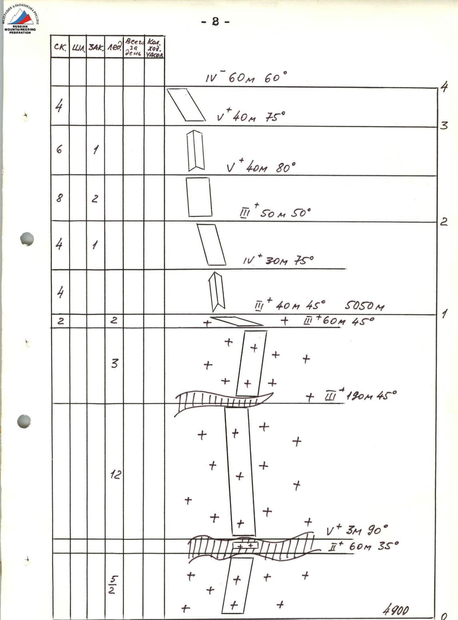
Route diagram in symbols. M 1:2000
| Section # | Rock Climbing | Ice Climbing | Pitons | Ice Screws | Total Day | Total Hours | Section Description (graphical / textual) |
|---|---|---|---|---|---|---|---|
| 1 | 4 | 1 | V⁺ 30 m 80° | ||||
| 2 | 21 | 2 | V⁺ 100 m 65° V⁺ 20 m 85° | ||||
| 3 | 5 | 1 | |||||
| 4 | 4 | IV⁺ 40 m 65° | |||||
| 5 | 3 | 2 | V⁺ 15 m 90° III 40 m 40° | ||||
| 6 | 2 | 2 | 2 | IV⁻ 40 m 65° | |||
| 7 | 3 | V⁺ 20 m 80° | |||||
| 8 | 8 | 3 | 90/4 | 12 | V⁺ 20 m 90° | ||
| 9 | 3/1 | 2 | IV⁻ 25 m 65° | ||||
| 10 | 2 | V⁺ 20 m 80° V⁺ 10 m 70° | |||||
| 11 | 3 | 2 | V⁺ 20 m 70° V⁺ 20 m 70° | ||||
| 12 | 2 | 1 | |||||
| 13 | 5/1 | 1 |
Route Description by Sections
The route begins on a snow-ice slope with two bergschrunds; the first is crossed using ladders, and the second is bypassed on the right. The exit to the rocks is in the middle part of a rock "island" resembling a comma. It's better to traverse the slope before 10:00 AM when it's not exposed to the sun.
Climb up the "comma" 30 m and then left and up along narrow, steep ledges to the upper edge of the counterfort.
- 40 m up, initially on a steep rock face;
- then 40 m along the edge (75–80°).
The rocks are crumbling, with loose stones, making it difficult to find secure belay points and reliable fixed ropes. Further:
- 60 m left and up along a worn counterfort to the right side of the main counterfort, leading to the pre-summit ridge;
- exit to the edge of the counterfort via a wall (20 m, 90°, artificial climbing techniques);
- along the edge of the counterfort with alternating walls (80–90°) to a snow patch;
- exit to the patch via a severely crumbling vertical wall (20 m, 90°, artificial climbing techniques).
From the right angle of the snow patch:
- 60 m up to a small cornice (the first safe bivouac site, control cairn);
- bypass the cornice on the right and exit to the edge of the counterfort (40 m), then to a large snow patch (40 m);
- through a snowfield to a wall (15 m, 90°);
- followed by a series of walls (15–20 m, 80–90°) along the counterfort and a wall under the pre-summit ridge.
The wall is 400 m long, heavily snow-covered, making it challenging to organize protection. There are no suitable bivouac sites until the pre-summit ridge. Bivouac on the ridge.
The ridge is snowy with ice sections and occasional cornices. It takes about an hour to reach the summit from the ridge. The cairn is located 20 m south of the summit on a rocky outcrop.
Descent:
- through the spurs of Peak Vysokaya Stena to the Tanymas-2 glacier — about 2 hours.