
PASSPORT
- High-altitude technical climb
- Pamir, Yazgulyam Range, Tanymas-3 glacier.
- Peak 6113 m, center of the North face.
- Proposed - 6B category of difficulty, first ascent.
- Height difference 1200 m, length of the wall part of the route 1450 m.
Length of sections with 5B category of difficulty - 620 m, 6B category of difficulty - 575 m. Average steepness of the main part of the route 68° (4900–6060), including 6B category of difficulty 80° (5420–5970).
- Pitons driven:
| rock | nut | bolt | ice |
|---|---|---|---|
| 151 | 122 | 1 | 17 |
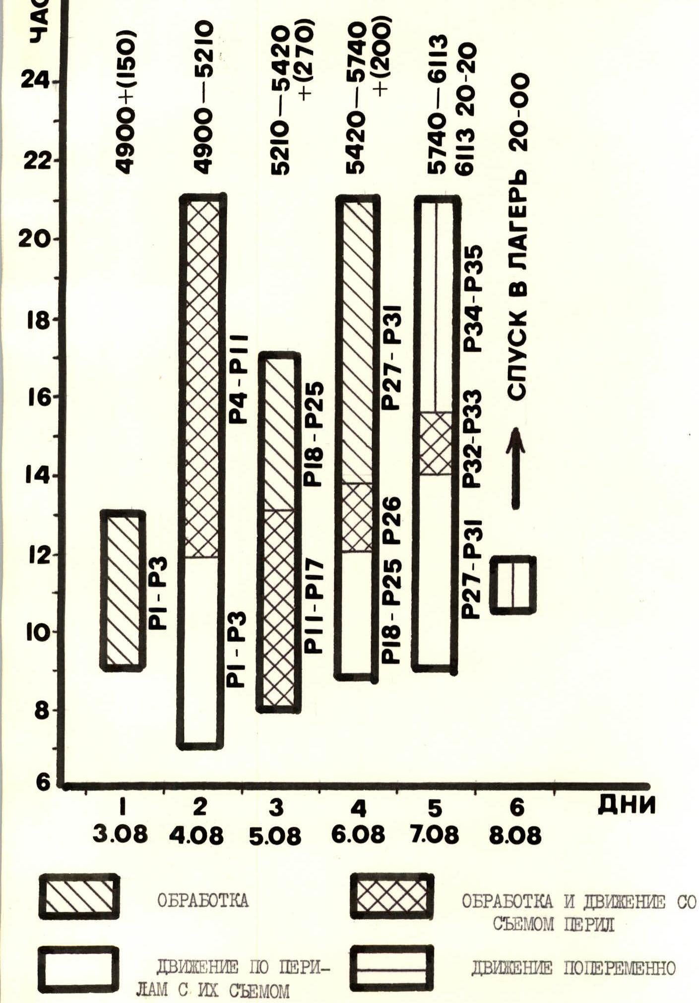
- Climbing hours (team) including processing: 51, days 5.
- Overnights: #1 (August 4) on a snowdrift in tents; #2 (August 5) under the black wall, sitting and half-lying on small ledges within a 15 m radius from each other; #3 (August 6) under the red wall, sitting and half-lying separately from each other; #4 (August 7) on a rocky ridge in tents.
- Leader: Bychek Alexander Mikhailovich MS; participants: Barsukov Valery Albertovich MS, Bogomolov Mikhail Gennadievich CMS, Goncharov Alexey Petrovich CMS, Kaloshin Sergey Alekseevich MS, Moskaltcov Alexey Vadimovich IMS, Sergeev Anatoly Leonidovich CMS, Tanec Anatoly Alexandrovich CMS.
- Coach: Polevoy Grigory Vladimirovich.
- Departure to the route: August 3, 1985. Summit: August 7. Return: August 8.
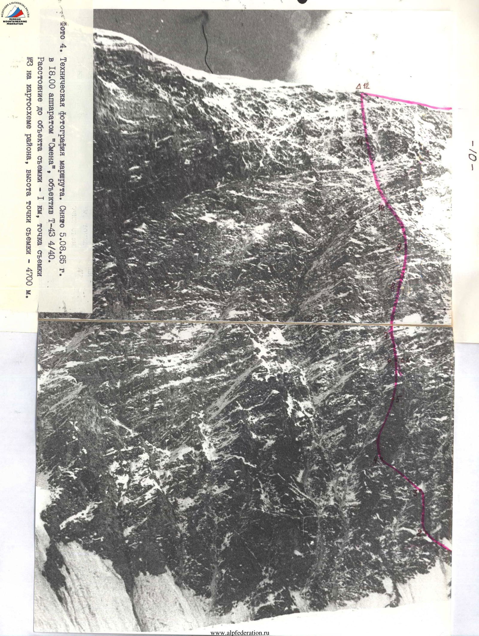
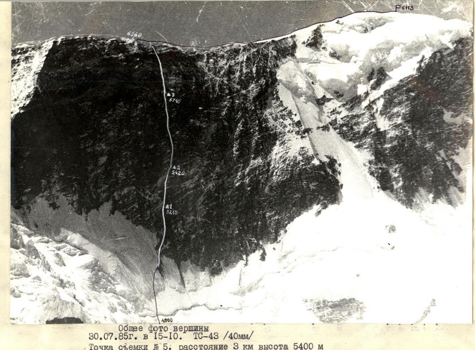 Photo 4. Technical photograph of the route. Taken on August 5, 1985 at 18:00 with a "Smena" camera, T-43 4/40 lens. Distance to the object - 1 km, shooting point #3 on the map of the area, height of the shooting point - 4700 m.
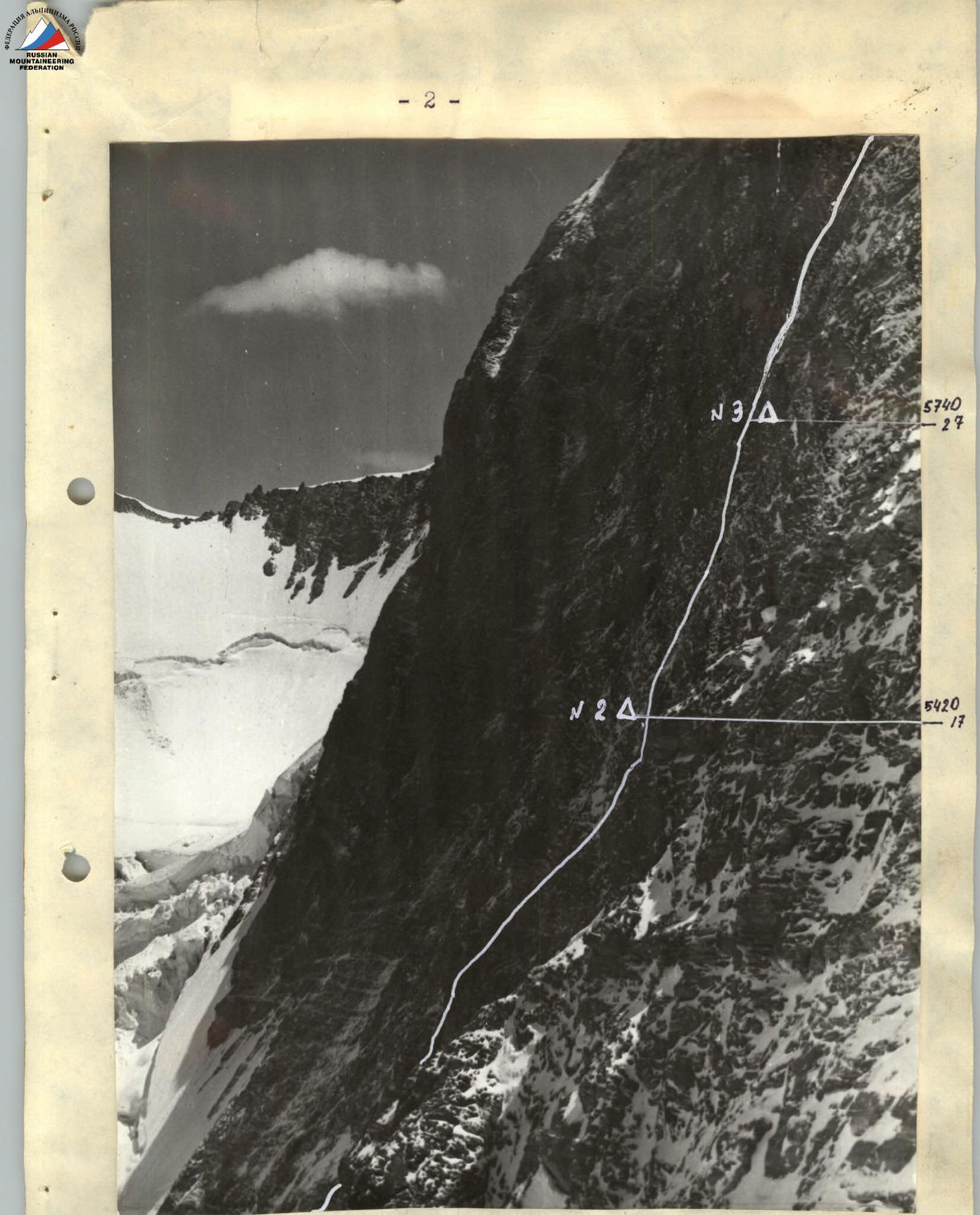
Profile of the middle part of the wall at 6113 m. T.S. #6. The photo was taken from a counterfort located to the right of the route, distance 0.5 km, height 5400 m. August 10, 1985 at 14:00. Helios 44/2 lens 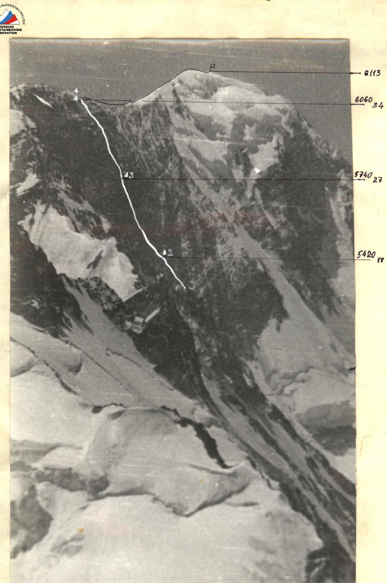
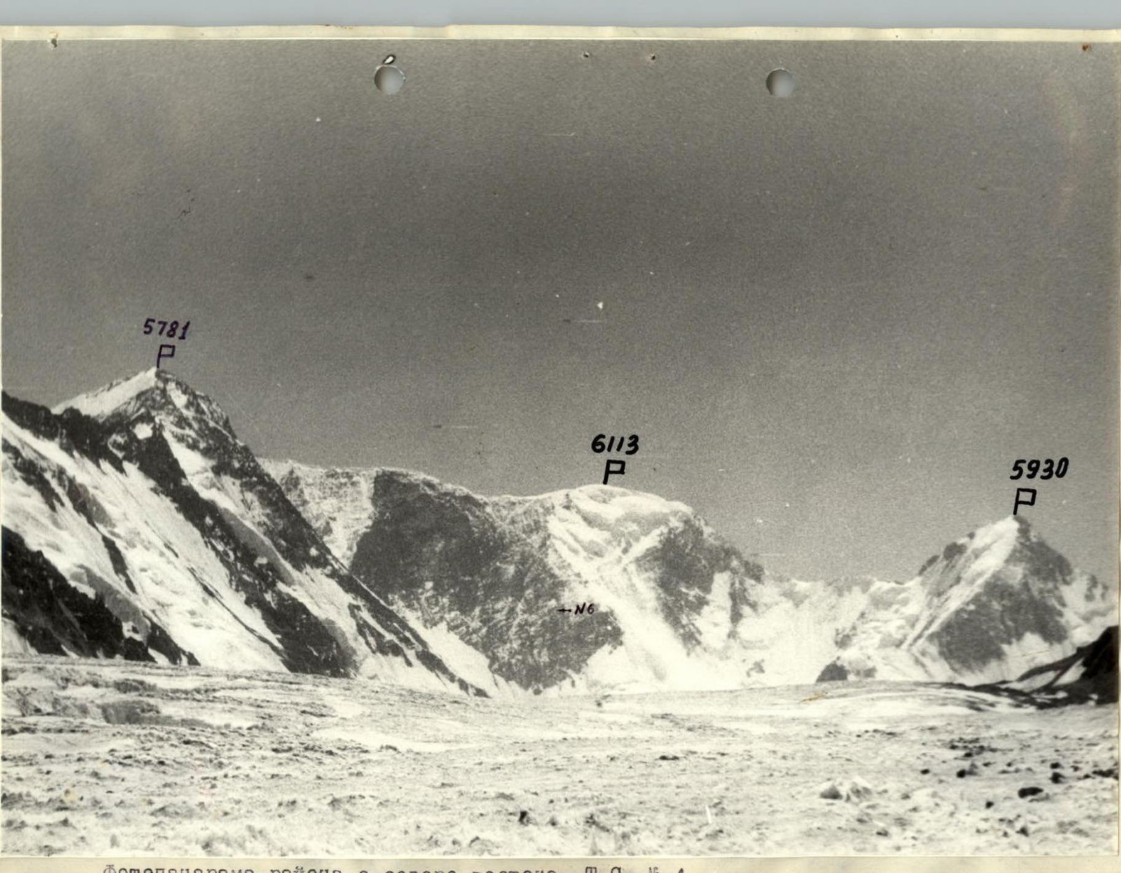
Semi-profile of the north face of 6113 m from the northeast. T.S. #3. The photo was taken from the top of Sredniy Tanymas, distance 6 km, height 5658 m. TS-43 lens on August 28, 1985 at 11:00.
Brief Overview of the Climbing Area
Peak 6113 m is located in the Pamir Mountains in the eastern spurs of the Yazgulyam Range between the Tanymas-3 glacier to the north and the Vitkovsky glacier to the south. The first topographic expeditions in 1928–1930 reached the area of the peak from the Tanymas river valley.
From the Tanymas-3 glacier to the Fedchenko glacier through the gorge upstream - 4 hours walk, to the weather station - about 12 hours.
The base camp was located near the tongue of the Tanymas-3 glacier on the slopes of Sredniy Tanymas peak, where there are good helicopter landing sites.
In the camp area, there is grass, and a stream runs nearby. The proximity of the Fedchenko glacier affects the weather in the area. A cold wind constantly blows down the gorge, and even on a sunny day, one has to walk in a down jacket.
From the base camp to the observation camp, it takes about 3 hours to walk up the Tanymas-3 glacier, and another 1–1.5 hours to reach the start of the route to the summit.
Before leaving for the mountains in Simferopol, the team received a consultation from I.G. Dorofeev, a participant in the first topographic expeditions, about the location of the peak and received a recommendation on the location of the base camp.
Preparation for the Ascent
The team became familiar with the object of the ascent in 1983 during the first ascent of the Cold Wall via the center of the north face (Verba route), observing peak 6113 m from a helicopter during one of the reconnaissance flights over the area.
The team, with year-round general physical training, conducted training camps in the Carpathians (January) and Crimea (May). The final stage of preparation was carried out in the Fann Mountains, in the Alaudin Lakes area, where all participants made several ascents of 5B category of difficulty, as well as:
- 15 people completed the Monogarov route, 6th category of difficulty, on Chapdara peak.
The north face of peak 6113 m with a height difference of up to 1.2 km has no previously climbed routes. We chose a complex, logical, and relatively safe route through the center of the wall.
The route in its lower part represents a snow-ice slope of about 50° and 240 m long, has three rocky bastions with steepness from 65–85° and a length of 1010 m, and in the upper part of the route, after the red bastion, a steep, ruined ridge with a steepness of 66° and a length of 180 m.
When choosing the route and drawing up a tactical plan (based on the results of reconnaissance on July 29 – August 1), it became clear that the left part of the wall is currently objectively dangerous due to the abundance of snow cornices.
Problematic sections: on R1 bastion, 160 m of steep icy rocks; on R2 bastion, 350 m of steep iced rocks, which are exposed to sunlight after 16:00; on R3 bastion, 240 m of sheer rocks with a minimal number of holds. The essence of the problem lies in:
- the great steepness and length of the rocky bastions,
- the presence of sheer walls with micro-holds, which complicates free climbing,
- the high steepness and length of sections of iced steep rocks,
- the location of key sections at an altitude above 5.5 thousand meters,
- the lack of convenient overnight stays in the middle and upper parts of the route on R2 and R3 bastions,
- severe frost on the wall due to it being exposed to sunlight at 16:00–17:00.
Solutions: applying the tactics of processing the wall in the second half of the day, including IMS and MS USSR in rock climbing in the team; using nut, skyhooks, and ice axes.
Safety measures: most of the route passes under overhanging sections, on ruined terrain, movement upwards - diagonally. Application of:
- double ropes and a compensator,
- "Karat" type radio station and constant radio communication between the base camp and Dushanbe,
- a numerous and qualified rescue team (3 MS, 6 CMS),
- a two-day supply of food for bad weather.
Ascent Schedule
Route Diagram in Symbols

Route Description by Sections
The team left the base camp, located in the lower reaches of the Tanymas-3 glacier, at 14:00 on August 2, 1985. The transition to the observation camp took 2 hours and 30 minutes.
August 3
Five people went to process the bergschrund and the ice slope. The triplet Sergeev-Tanec-Bogomolov worked ahead. The duo Bychek-Barsukov adjusted and observed. When passing icy walls, the first used ice axes.
R1: Firn slope leading to the bergschrund. Insurance through an ice axe driven in with a hammer.
R2: Broken bergschrund with a wall. Used ice screws and ice axes.
R3: Ice-firn slope with a wall. I.T.O., ice axes. Insurance through pitons.
On all sections, ropes were hung. Ahead, up to the bergschrund, was Sergeev; above, Bogomolov; and the last two ropes, with the exit to the rocks, were passed by Tanec. The rocks were covered in ice; the first worked in crampons.
August 4
The team in full passed the six processed ropes and climbed another 180 m to the planned overnight stay on a snowdrift. The rocks were steep and covered in ice. Many loose blocks made it difficult for the first climber. Moскальцов-Bychek worked ahead. The group, climbing on the hung ropes, waited in safe places to avoid being hit by stones from the climbers ahead, and the participants passed the dangerous sections one by one with necessary intervals.
R4: Rocks like "ram's foreheads," cracks filled with ice. R5: Wall made of rock slabs. R6: Ruined counterfort - movement along the right part. R7: Ruined wall. R8: Counterfort going up. Movement along the left part. Cracks filled with ice. R9: Crack upwards and then a wall. Pitons go in well. R10: Wall on the red counterfort, dissected, with a structure like "reverse tiles." R11: Ruined ridge, insurance through ledges.
At 21:00, the group organized a bivouac.
August 5
From the overnight stay, a yellow gendarme with a cornice at the bottom was visible to the right and upwards. Movement was first upwards 40 m to the wall, then to the right and upwards towards the gendarme.
The rocks were iced, made of slippery smooth slabs.
The duo Moskaltcov-Bychek worked ahead first, then Kaloshin-Barsukov.
Features of the passage:
- Cracks filled with ice
- Difficult to organize insurance
R12: Steep slabs, a shelf, and then a wall to the beginning of the counterfort.
R13: Counterfort to the right and upwards with alternating walls and small shelves. Very slippery, rocks iced.
R14: Counterfort with a 6-meter overhanging wall, then to the right and upwards, bypassing the gendarme.
R15: Vertical chimney with plugs. Insurance point organized to the left, 5 m away. Loose stones may fall.
R16: Wall with slabs filled with ice, passed upwards with a slight bias to the right. Stones from the wall may hit the lower participants in the chimney. Movement with intervals.
R17: Counterfort passed along the right part to the beginning of R2 bastion "black wall." Rocks are ruined. No convenient place for an overnight stay. The duo Kaloshin-Barsukov is ready for further processing; the rest of the group is organizing a bivouac.
R18: Narrow shelf with smoothed rocks to the left, 10 m to the base of the black well, upwards along the wall with two cornices. Kaloshin went ahead; he passed the cornices with free climbing. Barsukov straightened the rope.
R19: Wall with iced slabs. Movement to the left and upwards.
R20: Cornice 5 m, passed to the right with a transition to an internal corner with smoothed rocks.
R21: Wall with smoothed holds and a small number of cracks for pitons and nuts.
R22: Diagonal crack 10 m to a decrease in the cornice. Cornice 5 m and a steep wall.
R23: Internal corner filled with ice.
R24: Cornice 5 m, overhanging wall. The first hung a ladder twice.
R25: Steep ruined wall with slabs.
In total, 270 m of rocks of the second bastion were processed.
August 6
They went up along the hung ropes. After 40 m, all participants had to gather at the insurance point so that the two lower ropes could be freed, and the team could work on double and conditionally double ropes (using a rope).
Ahead, after the hung ropes, Tanec-Bogomolov worked, approaching the R3 bastion "red wall." The wall is very steep and complex. Ahead is a 100-meter overhanging belt of red rocks. To the right is an overhanging internal corner.
R26: Diagonal crack, slabs with loose blocks - movement towards a 10-meter chimney with a plug. It was supposed to organize an overnight stay here, but the place turned out to be unsuitable.
R27: Wall in the form of a split. Movement to the left and upwards. Kaloshin worked first. After a 5-meter pendulum, there was a snow- and ice-filled crack and a small shelf suitable for a sitting overnight stay. The overnight stay is located under a cornice and is safe.
R28: Wall to the right and upwards to the beginning of the overhanging internal corner, 5 m. The internal corner is passed with free climbing, and in the upper part, Sergey used a skyhook and a ladder. A bolt piton was driven at the insurance point.
R29: The overhanging internal corner continues. Climbing is extremely difficult. The wall and two alternating cornices require great tension. The complexity is increased by severe frost.
R30: Crack on the black wall towards the lowering of the cornice located above. The cornice is overcome straight upwards.
R31: Black wall with vaguely expressed internal corners. Pitons and nuts go in well.
R32: Wall intersected by red belts. The upper part is overhanging.
R33: Walls with shelves. Many loose stones.
R34: Ruined ridge with walls; nuts go in well.
R35: Sharp snow ridges with cornices and snowboards.
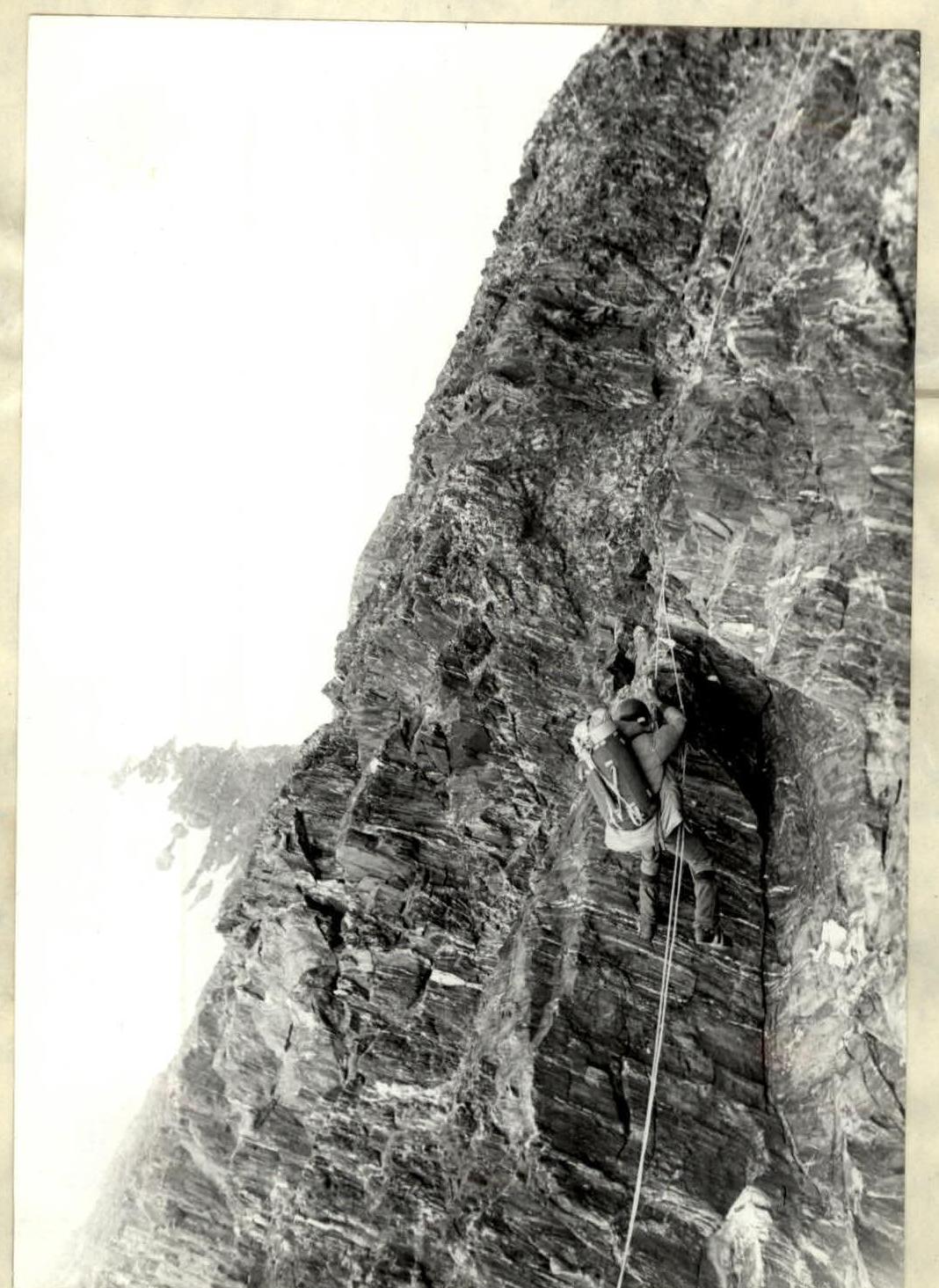
Photo 2. Ropes on section R18. August 6, 1985 at 10:00 with T-43 (40 mm) from R18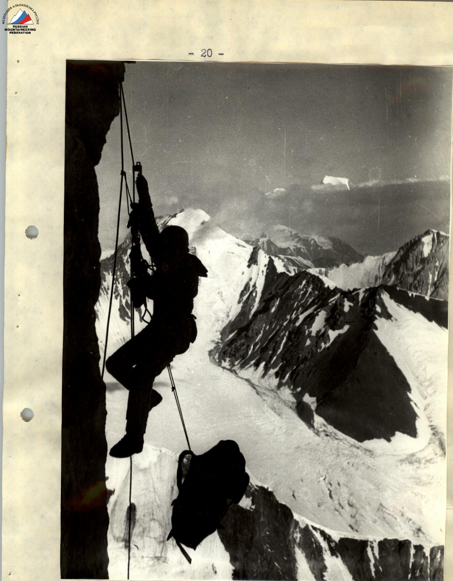
Photo 7. Work on the ropes on section R28. In the background - Peak Communism. August 7, 1985 at 9:30 with T-43 (40 mm) from R28